Illinois River At Morris (MORI2)
Return to TopNOTE: River forecasts for this location take into account past precipitation and the precipitation amounts expected approximately 24 hours into the future from the forecast issuance time.
Flood Stage: 16 Feet
Latest Stage: 6.73
Current Warnings/Statements/Advisories:None currently.
Flood Categories (in feet)
| Major Flood Stage: |
22 |
| Moderate Flood Stage: |
18 |
| Flood Stage: |
16 |
| Action Stage: |
13 |
| Low Stage (in feet): |
2.7 |
Historic Crests
(1) 24.91 ft on 04/19/2013
(2) 24.84 ft on 09/16/2008
(3) 24.80 ft on 05/19/2020
(4) 23.91 ft on 07/14/1957
(5) 23.90 ft on 02/21/1916
Show More Historic Crests
(P): Preliminary values subject to further review.
Recent Crests
(1) 24.80 ft on 05/19/2020
(2) 15.71 ft on 01/12/2020
(3) 18.43 ft on 09/29/2019
(4) 23.03 ft on 05/02/2019
(5) 14.79 ft on 06/23/2018
Show More Recent Crests
(P): Preliminary values subject to further review.
Low Water Records
(1) 0.27 ft on 07/20/1893
(2) 2.70 ft on 11/02/1904
(3) 4.43 ft on 09/13/2017
(4) 4.59 ft on 04/24/2021
(5) 4.80 ft on 08/01/1988
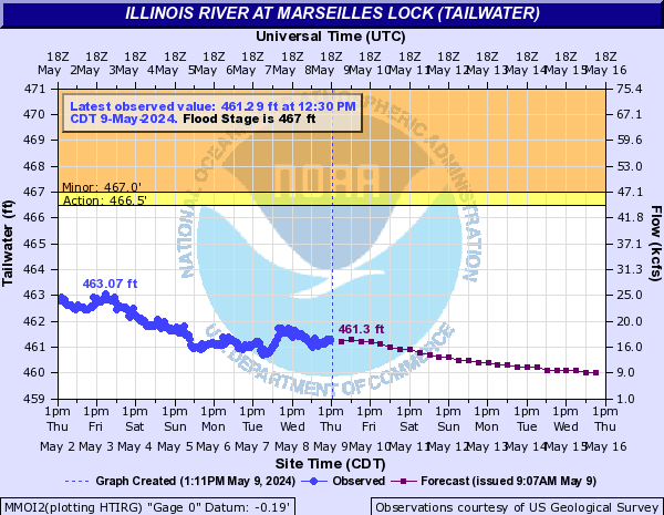
Illinois River At Marseilles Lock (tailwater) (MMOI2)
Return to TopNOTE: River forecasts for this location take into account past precipitation and the precipitation amounts expected approximately 48 hours into the future from the forecast issuance time.
Flood Stage: 467 Feet
Latest Stage: 460.57
Current Warnings/Statements/Advisories:None currently.
Flood Categories (in feet)
| Major Flood Stage: |
0 |
| Moderate Flood Stage: |
0 |
| Flood Stage: |
467 |
| Action Stage: |
466.5 |
| Low Stage (in feet): |
456.5 |
Historic Crests
(1) 476.72 ft on 04/19/2013
(2) 475.89 ft on 09/16/2008
(3) 475.84 ft on 05/19/2020
(4) 474.83 ft on 02/22/1997
(5) 474.70 ft on 04/09/1983
Show More Historic Crests
(P): Preliminary values subject to further review.
Recent Crests
(1) 475.84 ft on 05/19/2020
(2) 474.18 ft on 05/02/2019
(3) 474.26 ft on 02/22/2018
(4) 469.00 ft on 05/02/2017
(5) 471.12 ft on 12/30/2015
Show More Recent Crests
(P): Preliminary values subject to further review.
Low Water Records
Currently none available.
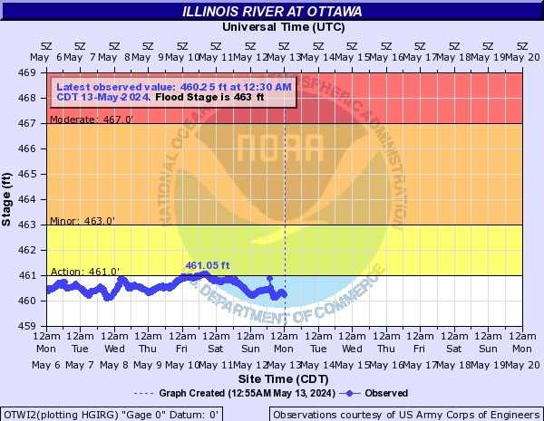
Illinois River At Ottawa (OTWI2)
Return to TopNOTE: River forecasts for this location take into account past precipitation and the precipitation amounts expected approximately 24 hours into the future from the forecast issuance time.
Flood Stage: 463 Feet
Latest Stage: 460.3
Current Warnings/Statements/Advisories:None currently.
Flood Categories (in feet)
| Major Flood Stage: |
471 |
| Moderate Flood Stage: |
467 |
| Flood Stage: |
463 |
| Action Stage: |
461 |
| Low Stage (in feet): |
456.5 |
Historic Crests
(1) 473.72 ft on 04/19/2013
(2) 472.59 ft on 05/19/2020
(3) 472.21 ft on 09/16/2008
(4) 471.49 ft on 02/22/2018
(5) 470.83 ft on 05/02/2019
Show More Historic Crests
(P): Preliminary values subject to further review.
Recent Crests
(1) 472.59 ft on 05/19/2020
(2) 470.83 ft on 05/02/2019
(3) 471.49 ft on 02/22/2018
(4) 463.65 ft on 10/16/2017
(5) 464.10 ft on 07/23/2017
Show More Recent Crests
(P): Preliminary values subject to further review.
Low Water Records
(1) 458.62 ft on 11/26/2018
(2) 458.65 ft on 01/22/2019
(3) 458.82 ft on 09/03/2017
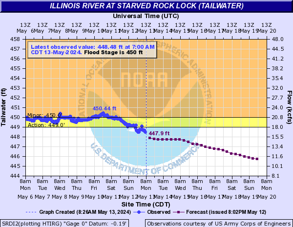
Illinois River At Starved Rock Lock (tailwater) (SRDI2)
Return to TopNOTE: River forecasts for this location take into account past precipitation and the precipitation amounts expected approximately 48 hours into the future from the forecast issuance time.
Flood Stage: 450 Feet
Latest Stage: 447.98
Current Warnings/Statements/Advisories:None currently.
Flood Categories (in feet)
| Major Flood Stage: |
465 |
| Moderate Flood Stage: |
460 |
| Flood Stage: |
450 |
| Action Stage: |
449 |
| Low Stage (in feet): |
438.7 |
Historic Crests
(1) 467.81 ft on 04/19/2013
(2) 467.31 ft on 09/16/2008
(3) 465.86 ft on 05/19/2020
(4) 464.70 ft on 12/05/1982
(5) 464.61 ft on 05/03/2019
Show More Historic Crests
(P): Preliminary values subject to further review.
Recent Crests
(1) 465.86 ft on 05/19/2020
(2) 464.61 ft on 05/03/2019
(3) 463.65 ft on 02/22/2018
(4) 460.14 ft on 05/02/2017
(5) 461.82 ft on 12/30/2015
Show More Recent Crests
(P): Preliminary values subject to further review.
Low Water Records
(1) 439.90 ft on 10/03/2012
(2) 440.34 ft on 10/01/2017
(3) 440.38 ft on 10/16/2015
(4) 440.78 ft on 09/28/2020
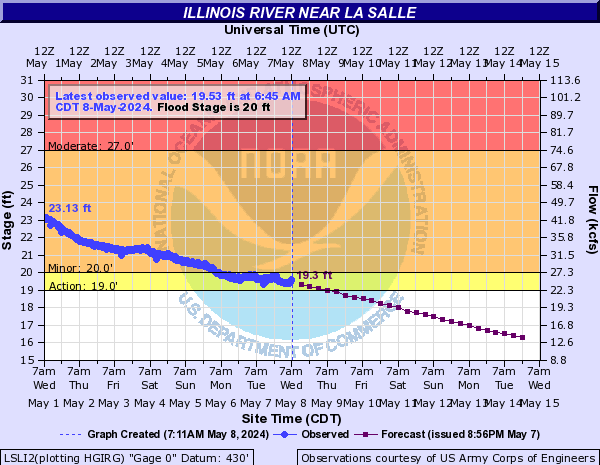
Illinois River Near La Salle (LSLI2)
Return to TopNOTE: River forecasts for this location take into account past precipitation and the precipitation amounts expected approximately 24 hours into the future from the forecast issuance time.
Flood Stage: 20 Feet
Latest Stage: 17.85
Current Warnings/Statements/Advisories:None currently.
Flood Categories (in feet)
| Major Flood Stage: |
31 |
| Moderate Flood Stage: |
27 |
| Flood Stage: |
20 |
| Action Stage: |
19 |
| Low Stage (in feet): |
8.7 |
Historic Crests
(1) 34.44 ft on 04/20/2013
(2) 33.79 ft on 09/16/2008
(3) 33.14 ft on 05/20/2020
(4) 32.14 ft on 05/03/2019
(5) 32.05 ft on 12/05/1982
Show More Historic Crests
(P): Preliminary values subject to further review.
Recent Crests
(1) 33.14 ft on 05/20/2020
(2) 26.54 ft on 05/01/2020
(3) 23.69 ft on 01/13/2020
(4) 24.56 ft on 11/01/2019
(5) 26.77 ft on 09/30/2019
Show More Recent Crests
(P): Preliminary values subject to further review.
Low Water Records (1) 1.80 ft on 08/28/1868
(2) 10.02 ft on 12/14/2010
(3) 10.05 ft on 02/03/2011
(4) 10.07 ft on 09/27/2012
(5) 10.14 ft on 01/06/2014
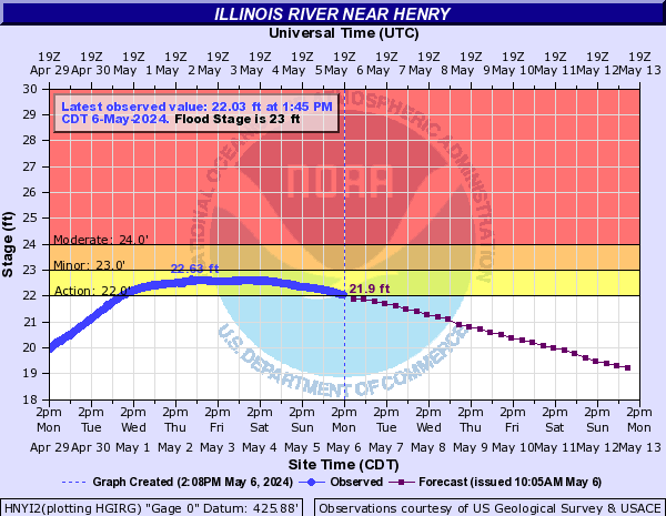
Show More Low Water Records Illinois River Near Henry (HNYI2)
Return to TopNOTE: River forecasts for this location take into account past precipitation and the precipitation amounts expected approximately 24 hours into the future from the forecast issuance time.
Flood Stage: 23 Feet
Latest Stage: 19.99
Current Warnings/Statements/Advisories:None currently.
Vertical Datum updated from NGVD29 to NAVD88 by gauge owner.
Flood Categories (in feet)
| Major Flood Stage: |
31 |
| Moderate Flood Stage: |
24 |
| Flood Stage: |
23 |
| Action Stage: |
22 |
| Low Stage (in feet): |
-9999 |
Historic Crests
(1) 32.94 ft on 04/22/2013
(2) 32.67 ft on 03/22/1979
(3) 32.20 ft on 05/23/1943
(4) 32.02 ft on 03/07/1985
(5) 31.62 ft on 05/21/2020
Show More Historic Crests
(P): Preliminary values subject to further review.
Recent Crests
(1) 25.55 ft on 01/31/2024
(P)
(2) 21.01 ft on 04/07/2023
(3) 21.33 ft on 03/09/2023
(P)
(4) 21.36 ft on 03/08/2023
(5) 21.20 ft on 05/09/2022
Show More Recent Crests
(P): Preliminary values subject to further review.
Low Water Records
Currently none available.
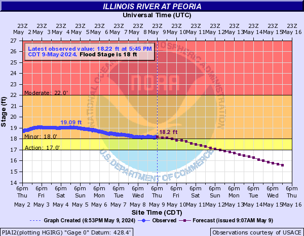
Illinois River At Peoria (PIAI2)
Return to TopNOTE: River forecasts for this location take into account past precipitation and the precipitation amounts expected approximately 24 hours into the future from the forecast issuance time.
Flood Stage: 18 Feet
Latest Stage: 16.6
Current Warnings/Statements/Advisories:None currently.
Flood Categories (in feet)
| Major Flood Stage: |
28 |
| Moderate Flood Stage: |
22 |
| Flood Stage: |
18 |
| Action Stage: |
17 |
| Low Stage (in feet): |
-9999 |
Historic Crests
(1) 29.35 ft on 04/23/2013
(2) 28.80 ft on 05/23/1943
(3) 28.70 ft on 03/23/1979
(4) 28.40 ft on 03/07/1985
(5) 28.00 ft on 05/07/2019
Show More Historic Crests
(P): Preliminary values subject to further review.
Recent Crests
(1) 21.66 ft on 02/02/2024
(P)
(2) 17.15 ft on 04/07/2023
(3) 17.48 ft on 03/10/2023
(4) 17.16 ft on 05/11/2022
(5) 19.21 ft on 04/09/2022
Show More Recent Crests
(P): Preliminary values subject to further review.
Low Water Records
Currently none available.
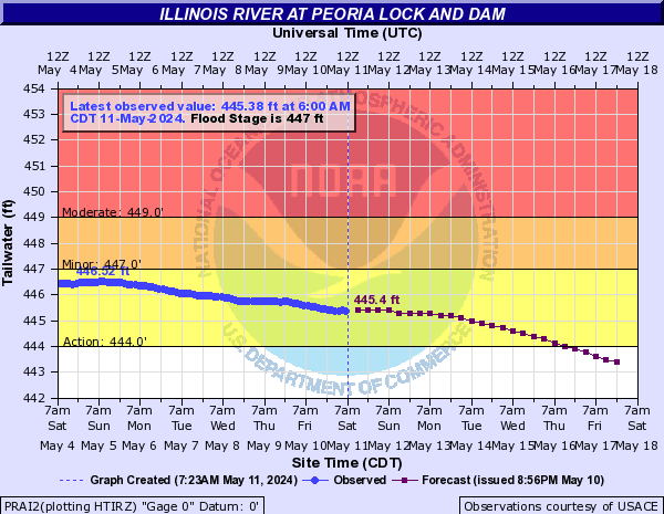
Illinois River At Peoria Lock and Dam (PRAI2)
Return to TopNOTE: River forecasts for this location take into account past precipitation and the precipitation amounts expected approximately 48 hours into the future from the forecast issuance time.
Flood Stage: 447 Feet
Latest Stage: 444.2
Current Warnings/Statements/Advisories:None currently.
Flood Categories (in feet)
| Major Flood Stage: |
455 |
| Moderate Flood Stage: |
449 |
| Flood Stage: |
447 |
| Action Stage: |
444 |
| Low Stage (in feet): |
-9999 |
Historic Crests
(1) 456.57 ft on 04/23/2013
(2) 455.90 ft on 05/24/1943
(3) 455.80 ft on 03/23/1979
(4) 455.60 ft on 03/08/1985
(5) 455.06 ft on 05/07/2019
Show More Historic Crests
(P): Preliminary values subject to further review.
Recent Crests
(1) 448.99 ft on 02/02/2024
(P)
(2) 444.48 ft on 04/07/2023
(3) 444.80 ft on 03/10/2023
(4) 444.45 ft on 05/11/2022
(5) 446.45 ft on 04/09/2022
Show More Recent Crests
(P): Preliminary values subject to further review.
Low Water Records
Currently none available.
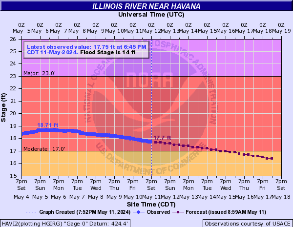
Illinois River Near Havana (HAVI2)
Return to TopNOTE: River forecasts for this location take into account past precipitation and the precipitation amounts expected approximately 24 hours into the future from the forecast issuance time.
Flood Stage: 14 Feet
Latest Stage: 16.35
Flood Categories (in feet)
| Major Flood Stage: |
23 |
| Moderate Flood Stage: |
17 |
| Flood Stage: |
14 |
| Action Stage: |
13 |
| Low Stage (in feet): |
-9999 |
Historic Crests
(1) 27.78 ft on 04/25/2013
(2) 27.24 ft on 07/01/2015
(3) 27.10 ft on 05/26/1943
(4) 26.80 ft on 01/04/2016
(5) 26.73 ft on 06/03/2019
Show More Historic Crests
(P): Preliminary values subject to further review.
Recent Crests
(1) 19.32 ft on 02/03/2024
(P)
(2) 15.97 ft on 04/06/2023
(3) 16.18 ft on 03/12/2023
(4) 16.08 ft on 05/12/2022
(5) 17.87 ft on 04/10/2022
Show More Recent Crests
(P): Preliminary values subject to further review.
Low Water Records
Currently none available.
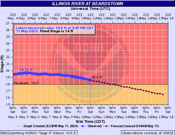
Illinois River At Beardstown (BEAI2)
Return to TopNOTE: River forecasts for this location take into account past precipitation and the precipitation amounts expected approximately 24 hours into the future from the forecast issuance time.
Flood Stage: 14 Feet
Latest Stage: 15.48
Flood Categories (in feet)
| Major Flood Stage: |
28 |
| Moderate Flood Stage: |
18 |
| Flood Stage: |
14 |
| Action Stage: |
13 |
| Low Stage (in feet): |
-9999 |
Historic Crests
(1) 29.81 ft on 04/27/2013
(2) 29.75 ft on 07/02/2015
(3) 29.60 ft on 05/26/1943
(4) 29.41 ft on 05/30/1995
(5) 29.23 ft on 01/05/2016
Show More Historic Crests
(P): Preliminary values subject to further review.
Recent Crests
(1) 20.15 ft on 02/05/2024
(P)
(2) 13.24 ft on 05/14/2023
(3) 15.91 ft on 04/07/2023
(4) 16.48 ft on 03/12/2023
(5) 13.76 ft on 06/02/2022
Show More Recent Crests
(P): Preliminary values subject to further review.
Low Water Records
Currently none available.
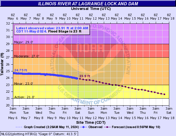
Illinois River At LaGrange Lock and Dam (NLGI2)
Return to TopNOTE: River forecasts for this location take into account past precipitation and the precipitation amounts expected approximately 24 hours into the future from the forecast issuance time.
Flood Stage: 23 Feet
Latest Stage: 20.21
Flood Categories (in feet)
| Major Flood Stage: |
29 |
| Moderate Flood Stage: |
27 |
| Flood Stage: |
23 |
| Action Stage: |
21 |
| Low Stage (in feet): |
-9999 |
Historic Crests
(1) 34.66 ft on 07/02/2015
(2) 34.50 ft on 04/27/2013
(3) 34.02 ft on 06/01/1995
(4) 33.89 ft on 06/04/2019
(5) 33.34 ft on 05/20/2002
(6) 32.80 ft on 04/19/1979
(7) 32.00 ft on 07/29/1993
(8) 32.00 ft on 04/29/1973
(9) 32.00 ft on 05/22/2009
(10) 31.35 ft on 05/27/2020
Show More Historic Crests
(P): Preliminary values subject to further review.
Recent Crests
(1) 24.27 ft on 07/07/2021
(2) 31.35 ft on 05/27/2020
(3) 23.62 ft on 01/24/2020
(4) 33.89 ft on 06/04/2019
(5) 24.88 ft on 04/01/2019
(6) 23.16 ft on 02/28/2019
(7) 23.93 ft on 02/17/2019
(8) 26.04 ft on 03/07/2018
(9) 29.75 ft on 05/08/2017
(10) 24.78 ft on 04/14/2017
Show More Recent Crests
(P): Preliminary values subject to further review.
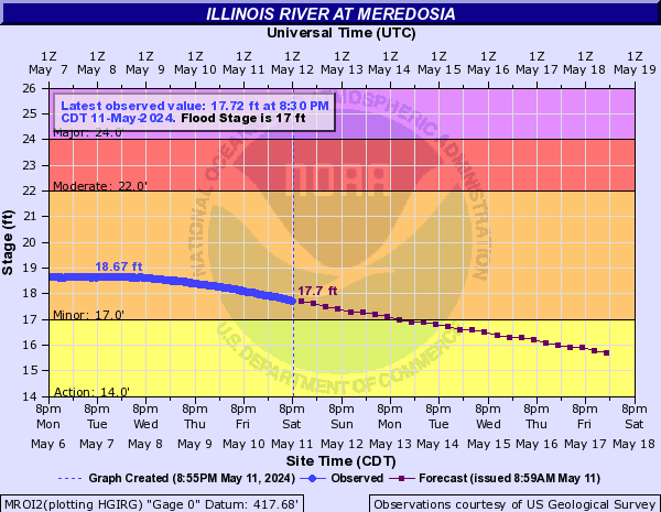
Illinois River At Meredosia (MROI2)
Return to TopNOTE: River forecasts for this location take into account past precipitation and the precipitation amounts expected approximately 24 hours into the future from the forecast issuance time.
Flood Stage: 17 Feet
Latest Stage: 14.19
Flood Categories (in feet)
| Major Flood Stage: |
24 |
| Moderate Flood Stage: |
22 |
| Flood Stage: |
17 |
| Action Stage: |
14 |
| Low Stage (in feet): |
-9999 |
Historic Crests
(1) 28.86 ft on 07/02/2015
(2) 28.70 ft on 05/26/1943
(3) 28.69 ft on 04/27/2013
(4) 28.39 ft on 06/04/2019
(5) 28.30 ft on 05/30/1995
(6) 28.03 ft on 01/05/2016
(7) 27.62 ft on 03/10/1985
(8) 27.57 ft on 05/19/2002
(9) 27.28 ft on 04/19/1979
(10) 26.96 ft on 07/28/1993
Show More Historic Crests
(P): Preliminary values subject to further review.
Recent Crests
(1) 25.39 ft on 05/27/2020
(2) 17.45 ft on 01/22/2020
(3) 28.39 ft on 06/04/2019
(4) 20.69 ft on 04/04/2019
(5) 17.04 ft on 02/27/2019
(6) 17.68 ft on 02/18/2019
(7) 19.72 ft on 03/03/2018
(8) 23.90 ft on 05/08/2017
(9) 18.29 ft on 04/14/2017
(10) 28.03 ft on 01/05/2016
Show More Recent Crests
(P): Preliminary values subject to further review.
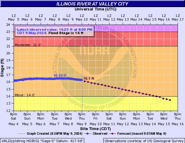
Illinois River At Valley City (VALI2)
Return to TopNOTE: River forecasts for this location take into account past precipitation and the precipitation amounts expected approximately 24 hours into the future from the forecast issuance time.
Flood Stage: 14 Feet
Latest Stage: 12.31
Current Warnings/Statements/Advisories:None currently.
Vertical Datum updated from NGVD29 to NAVD88 by gauge owner.
Flood Categories (in feet)
| Major Flood Stage: |
23 |
| Moderate Flood Stage: |
21 |
| Flood Stage: |
14 |
| Action Stage: |
11 |
| Low Stage (in feet): |
-9999 |
Historic Crests
(1) 27.00 ft on 05/26/1943
(2) 26.99 ft on 06/04/2019
(3) 26.85 ft on 07/02/2015
(4) 26.63 ft on 04/27/2013
(5) 26.56 ft on 05/30/1995
(6) 25.95 ft on 07/27/1993
(7) 25.72 ft on 01/05/2016
(8) 25.60 ft on 03/11/1985
(9) 25.56 ft on 03/24/1982
(10) 25.56 ft on 05/19/2002
Show More Historic Crests
(P): Preliminary values subject to further review.
Recent Crests
(1) 14.12 ft on 11/05/2021
(2) 16.10 ft on 07/10/2021
(3) 14.41 ft on 05/25/2021
(4) 23.15 ft on 05/27/2020
(5) 15.03 ft on 04/01/2020
(6) 15.68 ft on 01/22/2020
(7) 26.99 ft on 06/04/2019
(8) 15.20 ft on 02/27/2019
(9) 15.71 ft on 02/18/2019
(10) 17.62 ft on 03/07/2018
Show More Recent Crests
(P): Preliminary values subject to further review.
Illinois River At Hardin (HARI2)
Return to TopNOTE: River forecasts for this location take into account past precipitation and the precipitation amounts expected approximately 24 hours into the future from the forecast issuance time.
Flood Stage: 25 Feet
Latest Stage: 23.09
Current Warnings/Statements/Advisories:None currently.
Flood Categories (in feet)
| Major Flood Stage: |
32 |
| Moderate Flood Stage: |
31 |
| Flood Stage: |
25 |
| Action Stage: |
24 |
| Low Stage (in feet): |
-9999 |
Historic Crests
(1) 42.40 ft on 08/03/1993
(2) 40.29 ft on 06/07/2019
(3) 38.20 ft on 04/29/1973
(4) 36.87 ft on 12/31/2015
(5) 36.82 ft on 06/04/2013
(6) 36.70 ft on 05/29/1995
(7) 36.50 ft on 06/30/2015
(8) 36.50 ft on 04/14/1979
(9) 35.82 ft on 06/28/2008
(10) 35.22 ft on 05/06/2017
Show More Historic Crests
(P): Preliminary values subject to further review.
Recent Crests
(1) 25.83 ft on 05/16/2023
(2) 27.15 ft on 05/07/2022
(3) 25.11 ft on 04/10/2022
(4) 25.08 ft on 04/01/2022
(5) 25.88 ft on 07/18/2021
(6) 25.82 ft on 07/14/2021
(7) 25.23 ft on 07/11/2021
(8) 25.91 ft on 07/02/2021
(9) 25.09 ft on 06/28/2021
(10) 25.01 ft on 05/20/2021
Show More Recent Crests
(P): Preliminary values subject to further review.