Flood ImpactsIf you notice any errors in the below information, please contact our Webmaster
21.6
Flood water begins to hit the bottom of the bridge at the gage site.
18
Major flooding is in progress. Most county roads near the Mississinewa River are flooded.
16
Lincoln Blvd and Jay Street north of SR 15 in Gas City near the river is flooded. High water covers most county roads in the flood plain.
15
Some roads near the river are flooded.
14
Flooding in eastern and northern sections of Marion is common.
13
Boots Street begins to flood as water backs up Massey Creek.
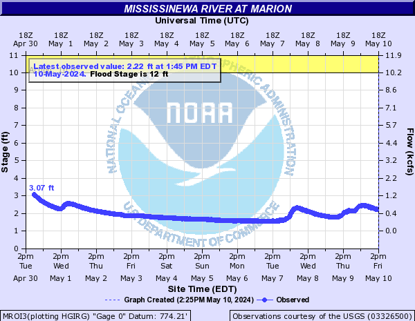
12.8
Flood waters cut off the Stone Crest Manor trailer park and the Quail Hollow neighborhood.
12
River is at flood stage. Water begins to enter Matter Park and crosses north Washington Street. Basements and homes along Boots Creek begin to flood. A few residents along River Road become concerned. Flood water approaches restaurant near Charles Park
10
A few residents become concerned if river continues to rise. County Road 1125 South near Matthews begins to flood.
8
River is near bankfull conditions.
Flood Categories (in feet)
| Major Flood Stage: |
16 |
| Moderate Flood Stage: |
13 |
| Flood Stage: |
12 |
| Action Stage: |
10 |
| Low Stage (in feet): |
-9999 |
Historic Crests
(1) 19.20 ft on 03/27/1913
(2) 17.40 ft on 03/21/1927
(3) 16.88 ft on 06/11/1958
(4) 16.80 ft on 05/19/1927
(5) 16.00 ft on 08/05/1998
Show More Historic Crests
(P): Preliminary values subject to further review.
Recent Crests
(1) 11.09 ft on 05/10/2021
(2) 11.53 ft on 01/12/2020
(3) 12.57 ft on 04/27/2019
(4) 11.07 ft on 04/04/2018
(5) 13.00 ft on 05/05/2017
Show More Recent Crests
(P): Preliminary values subject to further review.