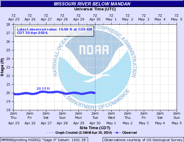
Missouri River Below Mandan (MMRN8)
Return to TopNOTE: Please report ice jams to local authorities.
Flood Stage: Not available
Latest Stage: 19.96
Flood Categories (in feet)
Historic Crests
Currently none available.
Recent Crests
Currently none available.
Low Water Records
Currently none available.
Missouri River At Oahe Dam (PIES2)
Return to TopNOTE: Gauge reading affected by reservoir operations.
Flood Stage: Not available
Latest Stage: 1602.19
Flood Categories (in feet)
| Major Flood Stage: |
1660 |
| Moderate Flood Stage: |
1644 |
| Flood Stage: |
0 |
| Action Stage: |
1617 |
| Low Stage (in feet): |
-9999 |
Historic Crests
(1) 1,619.68 ft on 06/26/2011
(2) 1,618.80 ft on 05/31/2019
(3) 1,618.71 ft on 06/25/1995
(4) 1,618.70 ft on 06/25/1996
(5) 1,618.60 ft on 05/01/1997
Show More Historic Crests
(P): Preliminary values subject to further review.
Recent Crests
(1) 1,618.80 ft on 05/31/2019
(2) 1,617.20 ft on 08/15/2018
(3) 1,611.10 ft on 09/15/2017
(4) 1,612.60 ft on 06/15/2016
(5) 1,613.50 ft on 07/15/2015
Show More Recent Crests
(P): Preliminary values subject to further review.
Low Water Records
Currently none available.
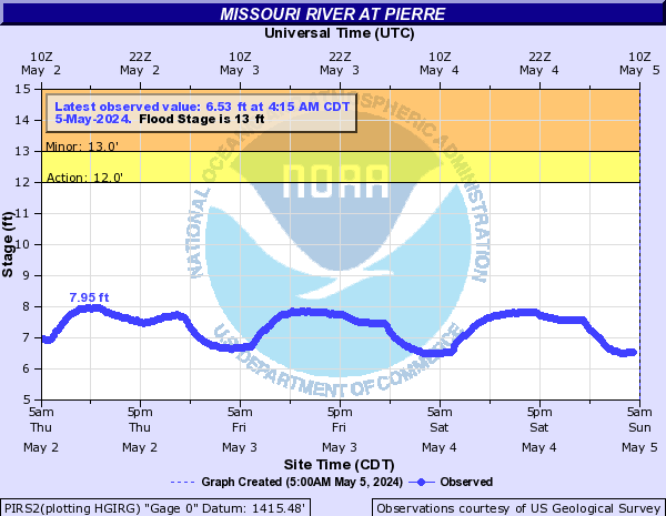
Missouri River At Pierre (PIRS2)
Return to TopNOTE: Gauge reading affected by reservoir operations.
Flood Stage: 13 Feet
Latest Stage: 7.26
Flood Categories (in feet)
| Major Flood Stage: |
24 |
| Moderate Flood Stage: |
21 |
| Flood Stage: |
13 |
| Action Stage: |
12 |
| Low Stage (in feet): |
-9999 |
Historic Crests
(1) 25.35 ft on 04/10/1952
(2) 23.00 ft on 03/01/1881
(3) 19.88 ft on 06/22/2011
Show More Historic Crests
(P): Preliminary values subject to further review.
Recent Crests
(1) 12.82 ft on 10/25/2019
(2) 12.43 ft on 09/07/2019
(3) 12.29 ft on 08/27/2018
Show More Recent Crests
(P): Preliminary values subject to further review.
Low Water Records
Currently none available.
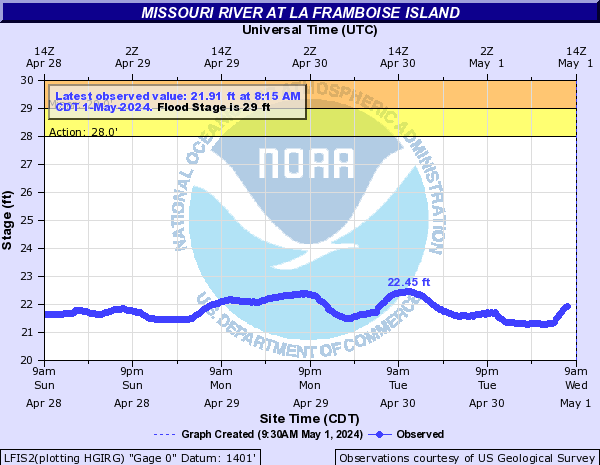
Missouri River At La Framboise Island (LFIS2)
Return to TopNOTE: Gauge reading affected by reservoir operations.
Flood Stage: 29 Feet
Latest Stage: 21.44
Flood Categories (in feet)
| Major Flood Stage: |
31 |
| Moderate Flood Stage: |
30 |
| Flood Stage: |
29 |
| Action Stage: |
28 |
| Low Stage (in feet): |
-9999 |
Historic Crests
(1) 33.45 ft on 06/22/2011
(2) 26.56 ft on 10/25/2019
(3) 25.99 ft on 10/17/1999
Show More Historic Crests
(P): Preliminary values subject to further review.
Recent Crests
(1) 26.56 ft on 10/25/2019
(2) 25.43 ft on 05/28/2019
(P)
(3) 25.71 ft on 08/30/2018
Show More Recent Crests
(P): Preliminary values subject to further review.
Low Water Records
Currently none available.
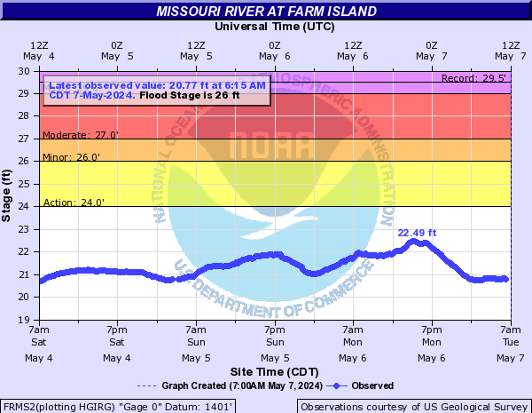
Missouri River At Farm Island (FRMS2)
Return to TopNOTE: Gauge reading affected by reservoir operations.
Flood Stage: 26 Feet
Latest Stage: 20.94
Flood Categories (in feet)
| Major Flood Stage: |
29 |
| Moderate Flood Stage: |
27 |
| Flood Stage: |
26 |
| Action Stage: |
24 |
| Low Stage (in feet): |
-9999 |
Historic Crests
(1) 29.52 ft on 06/21/2011
(2) 24.69 ft on 01/19/1996
(3) 24.53 ft on 10/20/2019
Show More Historic Crests
(P): Preliminary values subject to further review.
Recent Crests
(1) 24.53 ft on 10/20/2019
(2) 24.40 ft on 09/29/2019
(3) 23.87 ft on 08/30/2018
Show More Recent Crests
(P): Preliminary values subject to further review.
Low Water Records
Currently none available.
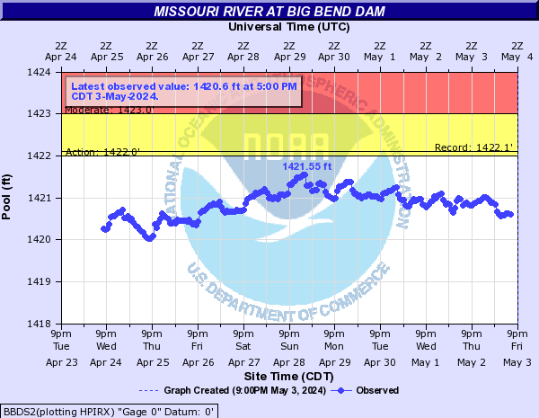
Missouri River At Big Bend Dam (BBDS2)
Return to TopNOTE: Gauge reading affected by reservoir operations.
Flood Stage: Not available
Latest Stage: 1420.9
Flood Categories (in feet)
| Major Flood Stage: |
1440 |
| Moderate Flood Stage: |
1423 |
| Flood Stage: |
0 |
| Action Stage: |
1422 |
| Low Stage (in feet): |
-9999 |
Historic Crests
(1) 1,422.10 ft on 06/04/1991
(2) 1,421.90 ft on 04/22/1971
(3) 1,421.80 ft on 06/22/2011
(4) 1,421.80 ft on 01/01/1999
(5) 1,421.60 ft on 01/01/1979
Show More Historic Crests
(P): Preliminary values subject to further review.
Recent Crests
(1) 1,421.50 ft on 02/04/2019
(2) 1,421.30 ft on 08/15/2018
(3) 1,421.30 ft on 07/15/2017
(4) 1,421.30 ft on 08/15/2016
(5) 1,421.40 ft on 05/15/2015
Show More Recent Crests
(P): Preliminary values subject to further review.
Low Water Records
Currently none available.
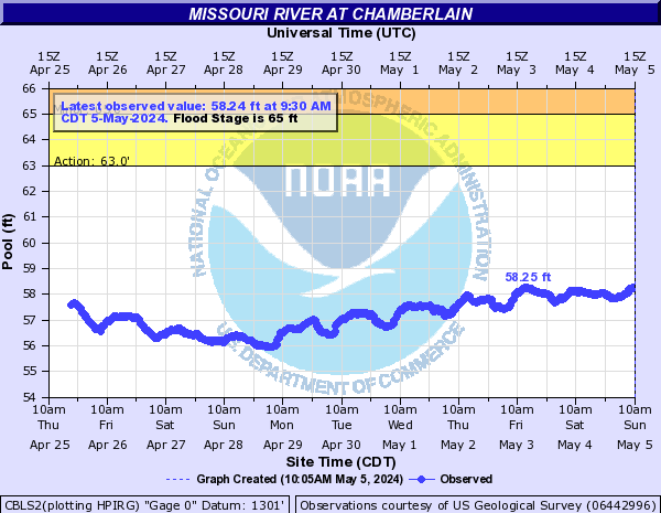
Missouri River At Chamberlain (CBLS2)
Return to TopNOTE: Gauge reading affected by reservoir operations.
Flood Stage: 65 Feet
Latest Stage: 56.52
Current Warnings/Statements/Advisories:None currently.
Flood Categories (in feet)
| Major Flood Stage: |
70 |
| Moderate Flood Stage: |
68 |
| Flood Stage: |
65 |
| Action Stage: |
63 |
| Low Stage (in feet): |
-9999 |
Historic Crests
(1) 75.08 ft on 07/08/2011
(2) 72.21 ft on 05/02/1997
(3) 71.08 ft on 06/02/2019
(4) 68.38 ft on 06/23/2010
(5) 67.93 ft on 06/02/1995
Show More Historic Crests
(P): Preliminary values subject to further review.
Recent Crests
(1) 57.91 ft on 06/02/2023
(2) 57.52 ft on 05/06/2022
(3) 57.11 ft on 09/02/2021
(4) 59.10 ft on 08/07/2020
(5) 71.08 ft on 06/02/2019
Show More Recent Crests
(P): Preliminary values subject to further review.
Low Water Records
Currently none available.
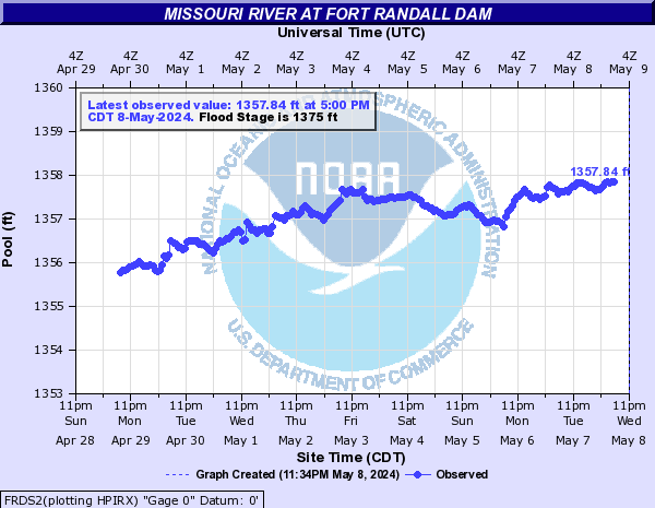
Missouri River At Fort Randall Dam (FRDS2)
Return to TopNOTE: Gauge reading affected by reservoir operations.
Flood Stage: 1375 Feet
Latest Stage: 1355.93
Current Warnings/Statements/Advisories:None currently.
Flood Categories (in feet)
| Major Flood Stage: |
1395 |
| Moderate Flood Stage: |
1379 |
| Flood Stage: |
1375 |
| Action Stage: |
1365 |
| Low Stage (in feet): |
-9999 |
Historic Crests
(1) 1,374.04 ft on 07/11/2011
(2) 1,372.17 ft on 05/07/1997
(3) 1,370.40 ft on 06/01/2019
(4) 1,368.10 ft on 06/01/2010
(5) 1,367.76 ft on 06/01/1995
Show More Historic Crests
(P): Preliminary values subject to further review.
Recent Crests
(1) 1,357.19 ft on 06/03/2023
(2) 1,357.84 ft on 08/01/2020
(3) 1,370.40 ft on 06/01/2019
(4) 1,357.69 ft on 06/21/2014
(5) 1,374.04 ft on 07/11/2011
Show More Recent Crests
(P): Preliminary values subject to further review.
Low Water Records
Currently none available.
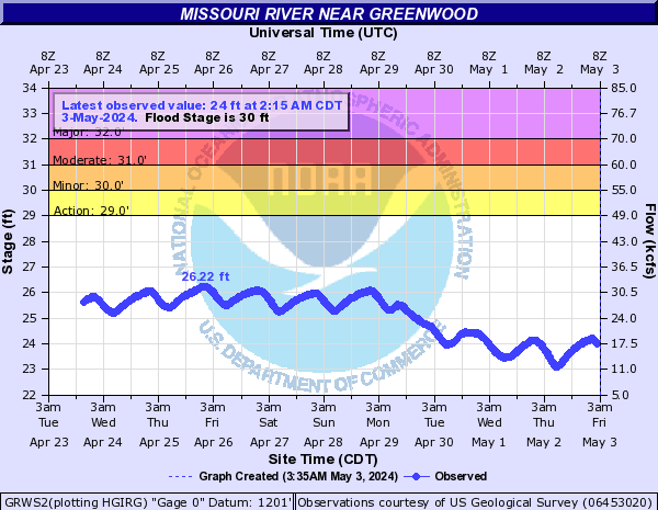
Missouri River Near Greenwood (GRWS2)
Return to TopNOTE: Gauge reading affected by reservoir operations.
Flood Stage: 30 Feet
Latest Stage: 25.32
Current Warnings/Statements/Advisories:None currently.
Flood Categories (in feet)
| Major Flood Stage: |
32 |
| Moderate Flood Stage: |
31 |
| Flood Stage: |
30 |
| Action Stage: |
29 |
| Low Stage (in feet): |
-9999 |
Historic Crests
(1) 38.78 ft on 07/07/2011
(2) 32.35 ft on 09/29/2019
(3) 31.89 ft on 10/08/1997
(4) 31.79 ft on 09/30/1997
(5) 30.76 ft on 09/05/1995
Show More Historic Crests
(P): Preliminary values subject to further review.
Recent Crests
(1) 27.06 ft on 10/03/2023
(2) 26.77 ft on 01/07/2022
(3) 26.44 ft on 09/29/2021
(4) 26.72 ft on 04/20/2020
(5) 32.35 ft on 09/29/2019
Show More Recent Crests
(P): Preliminary values subject to further review.
Low Water Records
Currently none available.
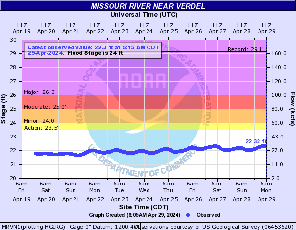
Missouri River Near Verdel (MRVN1)
Return to TopNOTE: Gauge reading affected by reservoir operations.
Flood Stage: 24 Feet
Latest Stage: 22.11
Current Warnings/Statements/Advisories:None currently.
Flood Categories (in feet)
| Major Flood Stage: |
26 |
| Moderate Flood Stage: |
25 |
| Flood Stage: |
24 |
| Action Stage: |
23.5 |
| Low Stage (in feet): |
-9999 |
Historic Crests
(1) 29.12 ft on 06/30/2011
(2) 26.82 ft on 03/14/2019
(3) 25.58 ft on 07/22/2010
(4) 25.02 ft on 08/22/1995
(5) 24.90 ft on 11/28/1997
Show More Historic Crests
(P): Preliminary values subject to further review.
Recent Crests
(1) 22.69 ft on 10/13/2023
(2) 22.23 ft on 06/10/2020
(3) 26.82 ft on 03/14/2019
(4) 24.40 ft on 08/17/2018
(5) 22.64 ft on 06/02/2017
Show More Recent Crests
(P): Preliminary values subject to further review.
Low Water Records
Currently none available.
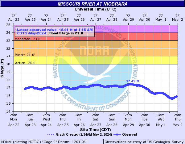
Missouri River At Niobrara (MRNN1)
Return to TopNOTE: Gauge reading affected by reservoir operations.
Flood Stage: 21 Feet
Latest Stage: 17.3
Current Warnings/Statements/Advisories:None currently.
Flood Categories (in feet)
| Major Flood Stage: |
24 |
| Moderate Flood Stage: |
23 |
| Flood Stage: |
21 |
| Action Stage: |
20 |
| Low Stage (in feet): |
-9999 |
Historic Crests
(1) 26.76 ft on 06/26/2011
(2) 23.64 ft on 07/22/2010
(3) 22.50 ft on 01/17/2007
(4) 22.20 ft on 08/05/2018
(5) 21.98 ft on 10/13/1997
Show More Historic Crests
(P): Preliminary values subject to further review.
Recent Crests
(1) 18.10 ft on 10/13/2023
(2) 17.08 ft on 08/17/2022
(3) 17.27 ft on 09/30/2021
(4) 18.27 ft on 06/10/2020
(5) 22.20 ft on 08/05/2018
Show More Recent Crests
(P): Preliminary values subject to further review.
Low Water Records
Currently none available.
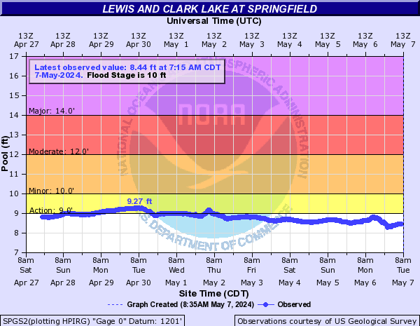
Missouri River At Springfield (SPGS2)
Return to TopNOTE: Gauge reading affected by reservoir operations.
Flood Stage: 10 Feet
Latest Stage: 8.82
Current Warnings/Statements/Advisories:None currently.
Flood Categories (in feet)
| Major Flood Stage: |
14 |
| Moderate Flood Stage: |
12 |
| Flood Stage: |
10 |
| Action Stage: |
9 |
| Low Stage (in feet): |
-9999 |
Historic Crests
(1) 17.73 ft on 03/14/2019
(2) 14.72 ft on 06/22/2011
(3) 12.00 ft on 10/14/2018
(4) 11.90 ft on 09/20/2018
(5) 11.89 ft on 08/23/1995
Show More Historic Crests
(P): Preliminary values subject to further review.
Recent Crests
(1) 10.14 ft on 10/14/2023
(2) 8.53 ft on 01/19/2022
(3) 9.27 ft on 01/27/2021
(4) 8.73 ft on 09/18/2020
(5) 17.73 ft on 03/14/2019
Show More Recent Crests
(P): Preliminary values subject to further review.
Low Water Records
Currently none available.
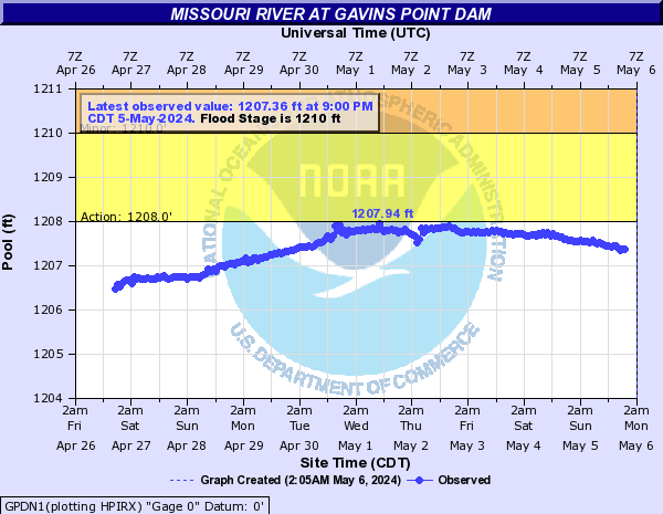
Missouri River At Gavins Point Dam (GPDN1)
Return to TopNOTE: Gauge reading affected by reservoir operations.
Flood Stage: 1210 Feet
Latest Stage: 1206.74
Current Warnings/Statements/Advisories:None currently.
Flood Categories (in feet)
| Major Flood Stage: |
1234 |
| Moderate Flood Stage: |
1221 |
| Flood Stage: |
1210 |
| Action Stage: |
1208 |
| Low Stage (in feet): |
-9999 |
Historic Crests
(1) 1,212.02 ft on 03/15/2019
(2) 1,210.60 ft on 04/01/1960
(3) 1,209.70 ft on 06/01/2010
(4) 1,209.23 ft on 05/30/1995
(5) 1,209.20 ft on 02/01/2007
Show More Historic Crests
(P): Preliminary values subject to further review.
Recent Crests
(1) 1,208.55 ft on 12/09/2023
(2) 1,207.82 ft on 07/28/2020
(3) 1,212.02 ft on 03/15/2019
(4) 1,207.25 ft on 06/10/2014
(5) 1,208.60 ft on 02/01/2011
Show More Recent Crests
(P): Preliminary values subject to further review.
Low Water Records
Currently none available.
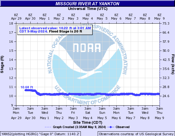
Missouri River At Yankton (YANS2)
Return to TopNOTE: Gauge reading affected by reservoir operations.
Flood Stage: 20 Feet
Latest Stage: 11.05
Current Warnings/Statements/Advisories:None currently.
Vertical datum height surveyed by the USGS
Flood Categories (in feet)
| Major Flood Stage: |
23 |
| Moderate Flood Stage: |
21 |
| Flood Stage: |
20 |
| Action Stage: |
18 |
| Low Stage (in feet): |
-9999 |
Historic Crests
(1) 50.50 ft on 04/05/1881
(2) 35.50 ft on 04/13/1952
(3) 34.80 ft on 03/22/1932
(4) 33.60 ft on 04/08/1943
(5) 31.60 ft on 04/24/1950
Show More Historic Crests
(P): Preliminary values subject to further review.
Recent Crests
(1) 12.07 ft on 09/26/2023
(2) 12.79 ft on 07/06/2020
(3) 19.22 ft on 03/15/2019
(4) 12.92 ft on 05/31/2017
(5) 12.09 ft on 10/16/2015
Show More Recent Crests
(P): Preliminary values subject to further review.
Low Water Records
Currently none available.
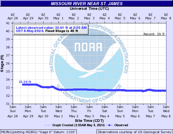
Missouri River Near St. James (MSJN1)
Return to TopNOTE: Gauge reading affected by reservoir operations.
Flood Stage: 45 Feet
Latest Stage: 33.3
Current Warnings/Statements/Advisories:None currently.
Flood Categories (in feet)
| Major Flood Stage: |
50 |
| Moderate Flood Stage: |
48 |
| Flood Stage: |
45 |
| Action Stage: |
43 |
| Low Stage (in feet): |
-9999 |
Historic Crests
(1) 39.50 ft on 03/15/2019
(2) 36.61 ft on 01/05/2015
(3) 35.96 ft on 09/12/2014
(4) 34.91 ft on 04/01/2020
(5) 34.56 ft on 01/14/2017
Show More Historic Crests
(P): Preliminary values subject to further review.
Recent Crests
(1) 34.00 ft on 09/27/2023
(2) 34.43 ft on 01/08/2022
(3) 33.51 ft on 08/20/2021
(4) 34.91 ft on 04/01/2020
(5) 39.50 ft on 03/15/2019
Show More Recent Crests
(P): Preliminary values subject to further review.
Low Water Records
Currently none available.
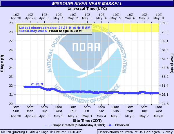
Missouri River Near Maskell (MKLN1)
Return to TopNOTE: Gauge reading affected by reservoir operations.
Flood Stage: 30 Feet
Latest Stage: 21.84
Current Warnings/Statements/Advisories:None currently.
Vertical datum height surveyed by the USGS
Flood Categories (in feet)
| Major Flood Stage: |
34 |
| Moderate Flood Stage: |
32 |
| Flood Stage: |
30 |
| Action Stage: |
28 |
| Low Stage (in feet): |
-9999 |
Historic Crests
(1) 31.86 ft on 06/29/2011
(2) 28.17 ft on 04/14/1997
(3) 27.25 ft on 07/17/1996
(4) 27.15 ft on 05/31/2019
(5) 26.95 ft on 10/06/1997
Show More Historic Crests
(P): Preliminary values subject to further review.
Recent Crests
(1) 22.97 ft on 09/11/2023
(2) 23.05 ft on 01/01/2023
(3) 22.14 ft on 08/16/2022
(4) 21.98 ft on 08/29/2021
(5) 21.92 ft on 04/15/2020
Show More Recent Crests
(P): Preliminary values subject to further review.
Low Water Records
Currently none available.
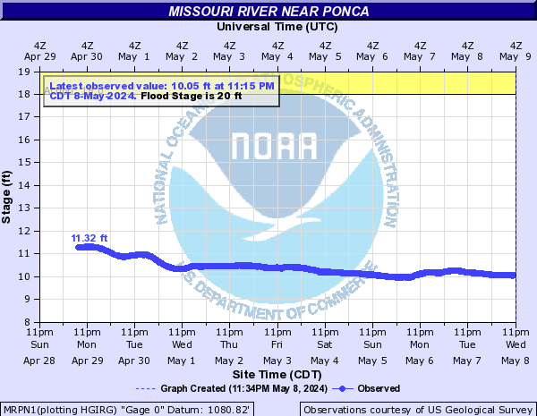
Missouri River Near Ponca (MRPN1)
Return to TopNOTE: Gauge reading affected by reservoir operations.
Flood Stage: 20 Feet
Latest Stage: 11.31
Current Warnings/Statements/Advisories:None currently.
Flood Categories (in feet)
| Major Flood Stage: |
24 |
| Moderate Flood Stage: |
22 |
| Flood Stage: |
20 |
| Action Stage: |
18 |
| Low Stage (in feet): |
-9999 |
Historic Crests
(1) 29.15 ft on 07/20/2011
(2) 21.30 ft on 03/17/2019
(3) 13.77 ft on 03/19/2023
(4) 12.58 ft on 04/03/2020
(P): Preliminary values subject to further review.
Recent Crests
(1) 13.77 ft on 03/19/2023
(2) 12.58 ft on 04/03/2020
(3) 21.30 ft on 03/17/2019
(4) 29.15 ft on 07/20/2011
(P): Preliminary values subject to further review.
Low Water Records
Currently none available.
Missouri River At Sioux City (SSCN1)
Return to TopNOTE: River forecasts for this location take into account past precipitation and the precipitation amounts expected approximately 48 hours into the future from the forecast issuance time.
NOTE: Gauge reading affected by reservoir operations.
Flood Stage: 30 Feet
Latest Stage: 13.66
Current Warnings/Statements/Advisories:None currently.
Flood Categories (in feet)
| Major Flood Stage: |
36 |
| Moderate Flood Stage: |
33 |
| Flood Stage: |
30 |
| Action Stage: |
25 |
| Low Stage (in feet): |
4 |
Historic Crests
(1) 44.28 ft on 04/14/1952
(2) 38.72 ft on 04/10/1943
(3) 38.44 ft on 04/25/1950
(4) 35.72 ft on 04/10/1949
(5) 35.45 ft on 04/12/1944
Show More Historic Crests
(P): Preliminary values subject to further review.
Recent Crests
(1) 13.76 ft on 09/21/2023
(2) 12.87 ft on 08/16/2022
(3) 18.12 ft on 04/01/2020
(4) 25.92 ft on 10/21/2019
(5) 30.27 ft on 06/01/2019
Show More Recent Crests
(P): Preliminary values subject to further review.
Low Water Records (1) 2.02 ft on 01/14/2024
(2) 2.44 ft on 12/17/2022
(3) 2.97 ft on 01/02/2022
(4) 4.12 ft on 12/30/2013
(5) 6.93 ft on 01/19/1996
Show More Low Water Records Missouri River At Decatur (DCTN1)
Return to TopNOTE: River forecasts for this location take into account past precipitation and the precipitation amounts expected approximately 24 hours into the future from the forecast issuance time.
Flood Stage: 35 Feet
Latest Stage: 22.39
Current Warnings/Statements/Advisories:None currently.
Flood Categories (in feet)
| Major Flood Stage: |
41 |
| Moderate Flood Stage: |
38 |
| Flood Stage: |
35 |
| Action Stage: |
33 |
| Low Stage (in feet): |
12.5 |
Historic Crests
(1) 44.41 ft on 04/16/1952
(2) 40.24 ft on 07/21/2011
(3) 36.51 ft on 03/17/2019
(4) 36.42 ft on 09/20/2019
(5) 35.72 ft on 06/03/2019
(6) 34.60 ft on 06/26/1984
(7) 32.31 ft on 07/18/1996
(8) 32.19 ft on 07/16/1993
(9) 32.18 ft on 06/27/2018
(10) 31.99 ft on 04/15/1997
Show More Historic Crests
(P): Preliminary values subject to further review.
Recent Crests
(1) 21.73 ft on 08/16/2022
(2) 21.80 ft on 09/01/2021
(3) 27.64 ft on 04/02/2020
(4) 36.42 ft on 09/20/2019
(5) 35.72 ft on 06/03/2019
(6) 36.51 ft on 03/17/2019
(7) 32.18 ft on 06/27/2018
(8) 24.69 ft on 05/30/2017
(9) 23.64 ft on 06/19/2016
(10) 22.57 ft on 07/11/2015
Show More Recent Crests
(P): Preliminary values subject to further review.
Low Water Records
(1) 13.78 ft on 01/09/1989
Missouri River Near Blair (BLAN1)
Return to TopNOTE: River forecasts for this location take into account past precipitation and the precipitation amounts expected approximately 24 hours into the future from the forecast issuance time.
Flood Stage: 26.5 Feet
Latest Stage: 15.63
Current Warnings/Statements/Advisories:None currently.
Flood Categories (in feet)
| Major Flood Stage: |
33 |
| Moderate Flood Stage: |
28.5 |
| Flood Stage: |
26.5 |
| Action Stage: |
23.5 |
| Low Stage (in feet): |
8 |
Historic Crests
(1) 33.50 ft on 04/17/1952
(2) 32.73 ft on 06/29/2011
(3) 31.12 ft on 03/18/2019
(4) 29.61 ft on 06/03/2019
(5) 29.19 ft on 09/22/2019
Show More Historic Crests
(P): Preliminary values subject to further review.
Recent Crests
(1) 14.80 ft on 12/30/2022
(2) 14.72 ft on 09/01/2021
(3) 20.73 ft on 04/03/2020
(4) 29.19 ft on 09/22/2019
(5) 29.61 ft on 06/03/2019
Show More Recent Crests
(P): Preliminary values subject to further review.
Low Water Records
Currently none available.
Missouri River At Omaha (OMHN1)
Return to TopNOTE: River forecasts for this location take into account past precipitation and the precipitation amounts expected approximately 24 hours into the future from the forecast issuance time.
Flood Stage: 27 Feet
Latest Stage: 15.72
Current Warnings/Statements/Advisories:None currently.
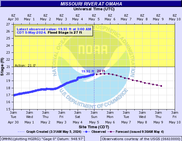
Flood Categories (in feet)
| Major Flood Stage: |
40 |
| Moderate Flood Stage: |
32 |
| Flood Stage: |
27 |
| Action Stage: |
21 |
| Low Stage (in feet): |
9 |
Historic Crests
(1) 40.20 ft on 04/18/1952
(2) 36.29 ft on 07/02/2011
(3) 34.40 ft on 03/17/2019
(4) 34.22 ft on 04/25/1881
(5) 31.96 ft on 06/05/2019
(6) 30.58 ft on 09/22/2019
(7) 30.26 ft on 07/10/1993
(8) 29.50 ft on 06/23/1996
(9) 29.02 ft on 06/27/1984
(10) 28.92 ft on 06/29/2018
Show More Historic Crests
(P): Preliminary values subject to further review.
Recent Crests
(1) 15.54 ft on 08/18/2022
(2) 16.06 ft on 08/07/2021
(3) 21.93 ft on 04/03/2020
(4) 30.58 ft on 09/22/2019
(5) 31.96 ft on 06/05/2019
(6) 34.40 ft on 03/17/2019
(7) 28.92 ft on 06/29/2018
(8) 22.43 ft on 05/21/2017
(9) 22.91 ft on 05/01/2016
(10) 21.86 ft on 12/15/2015
Show More Recent Crests
(P): Preliminary values subject to further review.
Low Water Records (1) 3.95 ft on 01/16/2024
(2) 4.09 ft on 12/24/2022
(3) 6.63 ft on 01/01/2014
(4) 6.64 ft on 02/03/2013
Show More Low Water Records Missouri River At Plattsmouth (PTMN1)
Return to TopNOTE: River forecasts for this location take into account past precipitation and the precipitation amounts expected approximately 24 hours into the future from the forecast issuance time.
Flood Stage: 26 Feet
Latest Stage: 16.16
Current Warnings/Statements/Advisories:None currently.
Flood Categories (in feet)
| Major Flood Stage: |
35 |
| Moderate Flood Stage: |
32 |
| Flood Stage: |
26 |
| Action Stage: |
25 |
| Low Stage (in feet): |
-9999 |
Historic Crests
(1) 40.62 ft on 03/16/2019
(2) 36.73 ft on 06/30/2011
(3) 35.65 ft on 07/25/1993
(4) 34.66 ft on 06/14/1984
(5) 33.08 ft on 06/14/2010
Show More Historic Crests
(P): Preliminary values subject to further review.
Recent Crests
(1) 17.20 ft on 06/18/2022
(2) 20.13 ft on 03/16/2021
(3) 24.30 ft on 05/27/2020
(4) 30.19 ft on 09/23/2019
(5) 32.11 ft on 06/04/2019
Show More Recent Crests
(P): Preliminary values subject to further review.
Low Water Records
Currently none available.
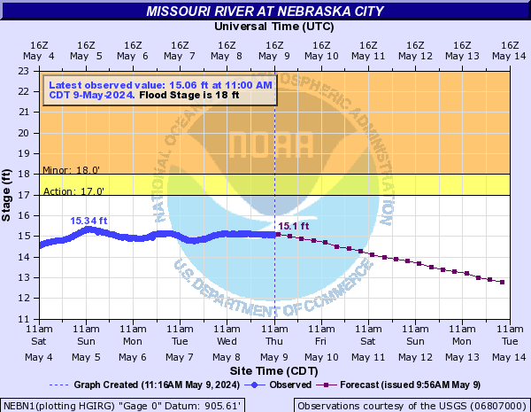
Missouri River At Nebraska City (NEBN1)
Return to TopNOTE: River forecasts for this location take into account past precipitation and the precipitation amounts expected approximately 24 hours into the future from the forecast issuance time.
Flood Stage: 18 Feet
Latest Stage: 10.51
Current Warnings/Statements/Advisories:None currently.
Flood Categories (in feet)
| Major Flood Stage: |
27 |
| Moderate Flood Stage: |
23 |
| Flood Stage: |
18 |
| Action Stage: |
17 |
| Low Stage (in feet): |
1.5 |
Historic Crests
(1) 30.12 ft on 03/16/2019
(2) 28.27 ft on 06/28/2011
(3) 27.19 ft on 07/23/1993
(4) 26.57 ft on 04/18/1952
(5) 25.21 ft on 06/21/2010
Show More Historic Crests
(P): Preliminary values subject to further review.
Recent Crests
(1) 11.86 ft on 03/01/2023
(2) 11.92 ft on 06/18/2022
(3) 14.25 ft on 03/16/2021
(4) 18.07 ft on 05/28/2020
(5) 22.93 ft on 09/24/2019
Show More Recent Crests
(P): Preliminary values subject to further review.
Low Water Records (1) -0.28 ft on 12/24/1960
(2) 0.25 ft on 12/12/1963
(3) 0.40 ft on 01/07/1971
(4) 0.52 ft on 12/19/1964
(5) 0.61 ft on 01/13/2024
Show More Low Water Records Missouri River At Brownville (BRON1)
Return to TopNOTE: River forecasts for this location take into account past precipitation and the precipitation amounts expected approximately 24 hours into the future from the forecast issuance time.
Flood Stage: 34 Feet
Latest Stage: 25.32
Current Warnings/Statements/Advisories:None currently.
Flood Categories (in feet)
| Major Flood Stage: |
43 |
| Moderate Flood Stage: |
38.5 |
| Flood Stage: |
34 |
| Action Stage: |
33 |
| Low Stage (in feet): |
16.5 |
Historic Crests
(1) 45.73 ft on 03/16/2019
(2) 44.79 ft on 06/23/2011
(3) 44.30 ft on 07/24/1993
(4) 42.89 ft on 06/23/2010
(5) 41.20 ft on 06/15/1984
Show More Historic Crests
(P): Preliminary values subject to further review.
Recent Crests
(1) 27.39 ft on 06/18/2022
(2) 29.52 ft on 03/16/2021
(3) 33.96 ft on 05/28/2020
(4) 39.45 ft on 06/05/2019
(5) 45.73 ft on 03/16/2019
Show More Recent Crests
(P): Preliminary values subject to further review.
Low Water Records
Currently none available.
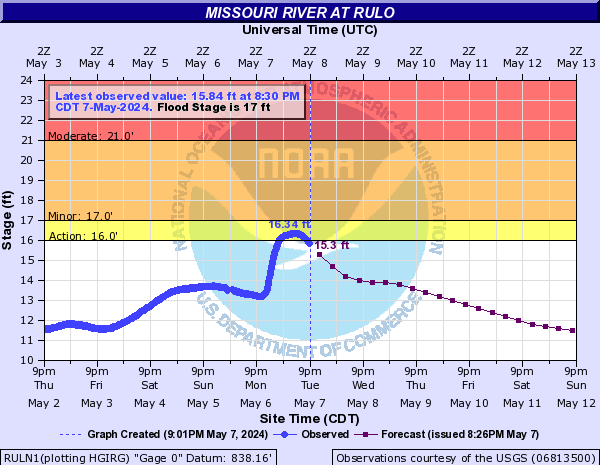
Missouri River At Rulo (RULN1)
Return to TopNOTE: River forecasts for this location take into account past precipitation and the precipitation amounts expected approximately 24 hours into the future from the forecast issuance time.
Flood Stage: 17 Feet
Latest Stage: 8.12
Current Warnings/Statements/Advisories:None currently.
Flood Categories (in feet)
| Major Flood Stage: |
26 |
| Moderate Flood Stage: |
21 |
| Flood Stage: |
17 |
| Action Stage: |
16 |
| Low Stage (in feet): |
-2 |
Historic Crests
(1) 28.13 ft on 03/20/2019
(2) 27.26 ft on 06/27/2011
(3) 26.63 ft on 06/23/2010
(4) 25.60 ft on 04/22/1952
(5) 25.37 ft on 07/24/1993
Show More Historic Crests
(P): Preliminary values subject to further review.
Recent Crests
(1) 13.63 ft on 05/26/2022
(2) 16.35 ft on 06/25/2021
(3) 18.88 ft on 05/26/2020
(4) 23.18 ft on 10/06/2019
(5) 24.86 ft on 05/29/2019
Show More Recent Crests
(P): Preliminary values subject to further review.
Missouri River At St. Joseph (SJSM7)
Return to TopNOTE: River forecasts for this location take into account past precipitation and the precipitation amounts expected approximately 24 hours into the future from the forecast issuance time.
Flood Stage: 17 Feet
Latest Stage: 7.73
Current Warnings/Statements/Advisories:None currently.
Vertical datum updated to 789.27 ft. NAVD88 or 788.95 ft.
NGVD29. More information - click
here
Flood Categories (in feet)
| Major Flood Stage: |
27 |
| Moderate Flood Stage: |
21 |
| Flood Stage: |
17 |
| Action Stage: |
14 |
| Low Stage (in feet): |
-9999 |
Historic Crests
(1) 32.07 ft on 03/22/2019
(2) 32.07 ft on 07/26/1993
(3) 29.97 ft on 06/28/2011
(4) 27.20 ft on 04/29/1881
(5) 26.82 ft on 04/22/1952
Show More Historic Crests
(P): Preliminary values subject to further review.
Recent Crests
(1) 20.40 ft on 06/25/2021
(2) 19.55 ft on 05/27/2020
(3) 24.74 ft on 10/03/2019
(4) 32.07 ft on 03/22/2019
(5) 19.02 ft on 12/02/2018
Show More Recent Crests
(P): Preliminary values subject to further review.
Missouri River At Atchison (ATCK1)
Return to TopNOTE: River forecasts for this location take into account past precipitation and the precipitation amounts expected approximately 24 hours into the future from the forecast issuance time.
Flood Stage: 22 Feet
Latest Stage: 9.88
Current Warnings/Statements/Advisories:None currently.
Flood Categories (in feet)
| Major Flood Stage: |
30 |
| Moderate Flood Stage: |
27 |
| Flood Stage: |
22 |
| Action Stage: |
19 |
| Low Stage (in feet): |
-9999 |
Historic Crests
(1) 31.63 ft on 07/26/1993
(2) 31.20 ft on 03/22/2019
(3) 31.00 ft on 06/29/2011
(4) 29.83 ft on 06/25/2010
(5) 29.50 ft on 04/23/1952
Show More Historic Crests
(P): Preliminary values subject to further review.
Recent Crests
(1) 22.10 ft on 08/18/2019
(2) 22.14 ft on 07/22/2019
(3) 29.26 ft on 05/31/2019
(4) 24.83 ft on 05/09/2019
(5) 31.20 ft on 03/22/2019
Show More Recent Crests
(P): Preliminary values subject to further review.
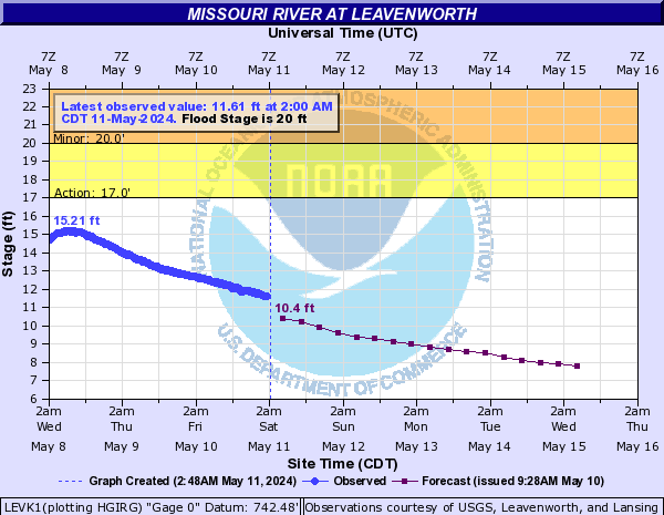
Missouri River At Leavenworth (LEVK1)
Return to TopNOTE: River forecasts for this location take into account past precipitation and the precipitation amounts expected approximately 24 hours into the future from the forecast issuance time.
Flood Stage: 20 Feet
Latest Stage: 5.26
Current Warnings/Statements/Advisories:None currently.
Vertical datum height surveyed by the USGS
Flood Categories (in feet)
| Major Flood Stage: |
30 |
| Moderate Flood Stage: |
24 |
| Flood Stage: |
20 |
| Action Stage: |
17 |
| Low Stage (in feet): |
-9999 |
Historic Crests
(1) 35.34 ft on 07/28/1993
(2) 31.31 ft on 03/23/2019
(3) 30.80 ft on 06/30/2011
(4) 28.66 ft on 06/01/2019
(5) 26.82 ft on 05/09/2007
Show More Historic Crests
(P): Preliminary values subject to further review.
Recent Crests
(1) 22.74 ft on 10/04/2019
(2) 28.66 ft on 06/01/2019
(3) 21.14 ft on 05/21/2019
(4) 21.92 ft on 05/10/2019
(5) 31.31 ft on 03/23/2019
Show More Recent Crests
(P): Preliminary values subject to further review.
Low Water Records
Currently none available.
Missouri River At Kansas City (KCDM7)
Return to TopNOTE: River forecasts for this location take into account past precipitation and the precipitation amounts expected approximately 24 hours into the future from the forecast issuance time.
Flood Stage: 32 Feet
Latest Stage: 10.32
Current Warnings/Statements/Advisories:None currently.
Flood Categories (in feet)
| Major Flood Stage: |
49 |
| Moderate Flood Stage: |
35 |
| Flood Stage: |
32 |
| Action Stage: |
29 |
| Low Stage (in feet): |
-9999 |
Historic Crests
(1) 48.87 ft on 07/27/1993
(2) 48.00 ft on 06/15/1844
(3) 46.20 ft on 07/14/1951
(4) 45.00 ft on 06/01/1903
(5) 40.60 ft on 04/24/1952
Show More Historic Crests
(P): Preliminary values subject to further review.
Recent Crests
(1) 33.93 ft on 06/25/2019
(2) 36.73 ft on 06/02/2019
(3) 34.41 ft on 03/24/2019
(4) 32.16 ft on 05/28/2016
(5) 32.60 ft on 07/10/2011
Show More Recent Crests
(P): Preliminary values subject to further review.
()
Return to TopFlood Flow: Not available
Latest Flow: n/a
Current Warnings/Statements/Advisories:None currently.
Flood Categories (in feet)
| Major Flood Stage: |
|
| Moderate Flood Stage: |
|
| Flood Stage: |
|
| Action Stage: |
|
| Low Stage (in feet): |
0 |
Historic Crests
Currently none available.
Recent Crests
Currently none available.
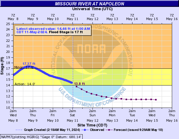
Missouri River At Napoleon (NAPM7)
Return to TopNOTE: River forecasts for this location take into account past precipitation and the precipitation amounts expected approximately 24 hours into the future from the forecast issuance time.
Flood Stage: 17 Feet
Latest Stage: 7.26
Current Warnings/Statements/Advisories:None currently.
Flood Categories (in feet)
| Major Flood Stage: |
30 |
| Moderate Flood Stage: |
25 |
| Flood Stage: |
17 |
| Action Stage: |
14 |
| Low Stage (in feet): |
-9999 |
Historic Crests
(1) 29.73 ft on 06/02/2019
(2) 28.86 ft on 05/09/2007
(3) 28.12 ft on 03/25/2019
(4) 27.60 ft on 07/10/2011
(5) 27.40 ft on 05/19/1995
Show More Historic Crests
(P): Preliminary values subject to further review.
Recent Crests
(1) 18.66 ft on 06/01/2022
(2) 17.27 ft on 06/30/2021
(3) 20.44 ft on 06/26/2021
(4) 22.03 ft on 07/31/2020
(5) 23.49 ft on 05/29/2020
Show More Recent Crests
(P): Preliminary values subject to further review.
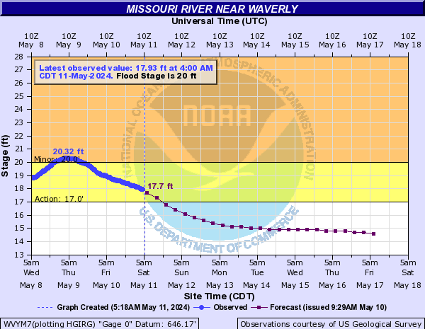
Missouri River Near Waverly (WVYM7)
Return to TopNOTE: River forecasts for this location take into account past precipitation and the precipitation amounts expected approximately 24 hours into the future from the forecast issuance time.
Flood Stage: 20 Feet
Latest Stage: 10.96
Current Warnings/Statements/Advisories:None currently.
Flood Categories (in feet)
| Major Flood Stage: |
31 |
| Moderate Flood Stage: |
29 |
| Flood Stage: |
20 |
| Action Stage: |
17 |
| Low Stage (in feet): |
-9999 |
Historic Crests
(1) 31.92 ft on 06/01/2019
(2) 31.61 ft on 03/26/2019
(3) 31.15 ft on 07/27/1993
(4) 30.75 ft on 07/09/2011
(5) 30.10 ft on 05/08/2007
Show More Historic Crests
(P): Preliminary values subject to further review.
Recent Crests
(1) 21.87 ft on 06/01/2022
(2) 21.27 ft on 07/01/2021
(3) 24.70 ft on 06/26/2021
(4) 20.24 ft on 03/18/2021
(5) 25.08 ft on 07/31/2020
Show More Recent Crests
(P): Preliminary values subject to further review.
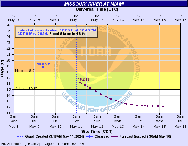
Missouri River At Miami (MIAM7)
Return to TopNOTE: River forecasts for this location take into account past precipitation and the precipitation amounts expected approximately 24 hours into the future from the forecast issuance time.
Flood Stage: 0 KCFS
Latest Flow: n/a
Current Warnings/Statements/Advisories:None currently.
Flood Categories (in feet)
| Major Flood Stage: |
29 |
| Moderate Flood Stage: |
28 |
| Flood Stage: |
18 |
| Action Stage: |
15 |
| Low Stage (in feet): |
-9999 |
Historic Crests
(1) 32.60 ft on 07/30/1993
(2) 31.53 ft on 06/01/2019
(3) 29.60 ft on 03/26/2019
(4) 29.48 ft on 05/11/2007
(5) 29.00 ft on 07/16/1951
Show More Historic Crests
(P): Preliminary values subject to further review.
Recent Crests
(1) 23.90 ft on 06/26/2021
(2) 22.90 ft on 08/01/2020
(3) 25.35 ft on 05/29/2020
(4) 31.53 ft on 06/01/2019
(5) 29.60 ft on 03/26/2019
Show More Recent Crests
(P): Preliminary values subject to further review.
Low Water Records
Currently none available.
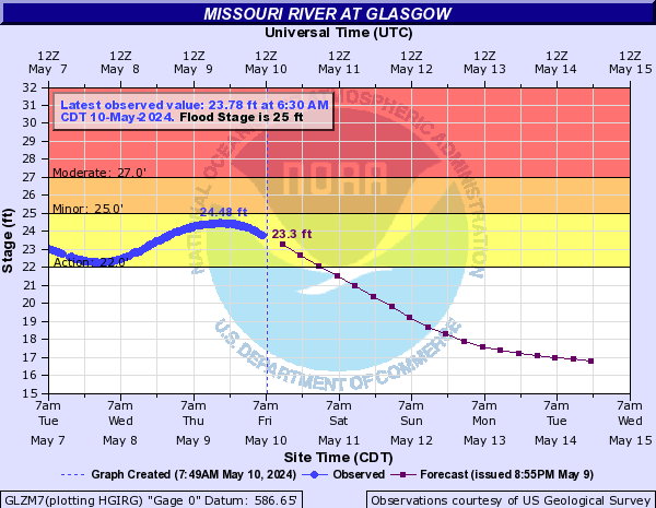
Missouri River At Glasgow (GLZM7)
Return to TopNOTE: River forecasts for this location take into account past precipitation and the precipitation amounts expected approximately 24 hours into the future from the forecast issuance time.
Flood Stage: 25 Feet
Latest Stage: 11.34
Current Warnings/Statements/Advisories:None currently.
Flood Categories (in feet)
| Major Flood Stage: |
32 |
| Moderate Flood Stage: |
27 |
| Flood Stage: |
25 |
| Action Stage: |
22 |
| Low Stage (in feet): |
-9999 |
Historic Crests
(1) 39.50 ft on 07/29/1993
(2) 37.40 ft on 07/13/1993
(3) 37.35 ft on 05/29/2019
(4) 36.70 ft on 07/17/1951
(5) 35.00 ft on 06/26/1947
Show More Historic Crests
(P): Preliminary values subject to further review.
Recent Crests
(1) 29.77 ft on 06/27/2021
(2) 25.04 ft on 03/18/2021
(3) 25.92 ft on 08/01/2020
(4) 30.30 ft on 05/30/2020
(5) 27.44 ft on 09/01/2019
Show More Recent Crests
(P): Preliminary values subject to further review.
Low Water Records
(1) 2.70 ft on 12/12/1937
(2) 3.90 ft on 12/21/1963
(3) 4.30 ft on 12/31/1935
Missouri River At Boonville (BOZM7)
Return to TopNOTE: River forecasts for this location take into account past precipitation and the precipitation amounts expected approximately 24 hours into the future from the forecast issuance time.
Flood Stage: 21 Feet
Latest Stage: 7.21
Current Warnings/Statements/Advisories:None currently.
Flood Categories (in feet)
| Major Flood Stage: |
34 |
| Moderate Flood Stage: |
30 |
| Flood Stage: |
21 |
| Action Stage: |
18 |
| Low Stage (in feet): |
-9999 |
Historic Crests
(1) 37.10 ft on 07/29/1993
(2) 33.73 ft on 05/31/2019
(3) 33.14 ft on 05/19/1995
(4) 32.70 ft on 06/21/1844
(5) 32.62 ft on 07/17/1951
Show More Historic Crests
(P): Preliminary values subject to further review.
Recent Crests
(1) 21.92 ft on 06/02/2022
(2) 27.87 ft on 06/27/2021
(3) 22.13 ft on 04/12/2021
(4) 23.17 ft on 03/18/2021
(5) 22.71 ft on 08/01/2020
Show More Recent Crests
(P): Preliminary values subject to further review.
Missouri River At Jefferson City (JFFM7)
Return to TopNOTE: River forecasts for this location take into account past precipitation and the precipitation amounts expected approximately 24 hours into the future from the forecast issuance time.
Flood Stage: 23 Feet
Latest Stage: 5.47
Current Warnings/Statements/Advisories:None currently.

Flood Categories (in feet)
| Major Flood Stage: |
30 |
| Moderate Flood Stage: |
25 |
| Flood Stage: |
23 |
| Action Stage: |
21 |
| Low Stage (in feet): |
-9999 |
Historic Crests
(1) 38.65 ft on 07/30/1993
(2) 34.20 ft on 07/18/1951
(3) 33.50 ft on 06/06/1903
(4) 33.41 ft on 06/07/2019
(5) 33.05 ft on 05/19/1995
(6) 32.61 ft on 06/28/1947
(7) 32.60 ft on 10/05/1986
(8) 32.18 ft on 04/27/1944
(9) 31.85 ft on 09/29/1993
(10) 31.40 ft on 04/24/1973
Show More Historic Crests
(P): Preliminary values subject to further review.
Recent Crests
(1) 27.58 ft on 06/28/2021
(2) 25.16 ft on 03/19/2021
(3) 25.27 ft on 05/31/2020
(4) 23.09 ft on 03/21/2020
(5) 26.10 ft on 10/07/2019
(6) 23.82 ft on 09/02/2019
(7) 33.41 ft on 06/07/2019
(8) 26.52 ft on 05/12/2019
(9) 28.13 ft on 05/03/2019
(10) 28.13 ft on 04/01/2019
Show More Recent Crests
(P): Preliminary values subject to further review.
Low Water Records (1) -2.89 ft on 12/29/2022
(2) -1.10 ft on 02/03/1908
(3) -0.42 ft on 02/19/2021
(4) -0.30 ft on 12/23/1989
(5) 0.00 ft on 01/04/1919
Show More Low Water Records Missouri River Near Chamois (CMSM7)
Return to TopNOTE: River forecasts for this location take into account past precipitation and the precipitation amounts expected approximately 24 hours into the future from the forecast issuance time.
Flood Stage: 17 Feet
Latest Stage: 2.5
Current Warnings/Statements/Advisories:None currently.
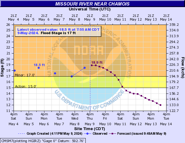
Flood Categories (in feet)
| Major Flood Stage: |
31 |
| Moderate Flood Stage: |
28 |
| Flood Stage: |
17 |
| Action Stage: |
15 |
| Low Stage (in feet): |
-9999 |
Historic Crests
(1) 33.30 ft on 07/31/1993
(2) 29.60 ft on 06/07/2019
(3) 28.70 ft on 04/24/1973
(4) 28.30 ft on 05/04/2017
(5) 28.00 ft on 12/29/2015
(6) 27.92 ft on 06/02/2013
(7) 27.17 ft on 09/16/2008
(8) 26.70 ft on 05/18/1990
(9) 26.30 ft on 02/25/1985
(10) 26.30 ft on 04/13/1994
Show More Historic Crests
(P): Preliminary values subject to further review.
Recent Crests
(1) 18.50 ft on 06/03/2023
(2) 18.50 ft on 05/06/2022
(3) 23.70 ft on 06/28/2021
(4) 19.90 ft on 04/12/2021
(5) 23.30 ft on 03/19/2021
(6) 17.70 ft on 08/02/2020
(7) 22.00 ft on 05/30/2020
(8) 20.90 ft on 03/20/2020
(9) 17.00 ft on 03/12/2020
(10) 20.10 ft on 01/11/2020
Show More Recent Crests
(P): Preliminary values subject to further review.
Low Water Records (1) -5.75 ft on 12/31/2022
(2) -5.70 ft on 12/22/1963
(3) -4.40 ft on 12/29/2000
(4) -4.30 ft on 12/21/1989
(5) -4.20 ft on 01/17/1967
Show More Low Water Records ()
Return to TopFlood Flow: Not available
Latest Flow: n/a
Current Warnings/Statements/Advisories:None currently.
Flood Categories (in feet)
| Major Flood Stage: |
|
| Moderate Flood Stage: |
|
| Flood Stage: |
|
| Action Stage: |
|
| Low Stage (in feet): |
0 |
Historic Crests
Currently none available.
Recent Crests
Currently none available.
Missouri River At Hermann (HRNM7)
Return to TopNOTE: River forecasts for this location take into account past precipitation and the precipitation amounts expected approximately 24 hours into the future from the forecast issuance time.
Flood Stage: 21 Feet
Latest Stage: 5.32
Current Warnings/Statements/Advisories:None currently.
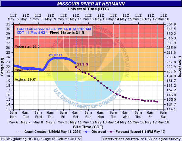
Flood Categories (in feet)
| Major Flood Stage: |
33 |
| Moderate Flood Stage: |
26 |
| Flood Stage: |
21 |
| Action Stage: |
19 |
| Low Stage (in feet): |
-9999 |
Historic Crests
(1) 36.97 ft on 07/31/1993
(2) 36.22 ft on 05/19/1995
(3) 35.79 ft on 10/05/1986
(4) 35.62 ft on 05/04/2017
(5) 35.50 ft on 06/01/1844
(6) 34.82 ft on 12/30/2015
(7) 33.66 ft on 04/24/1973
(8) 33.52 ft on 06/08/2019
(9) 33.33 ft on 07/19/1951
(10) 33.14 ft on 06/02/2013
Show More Historic Crests
(P): Preliminary values subject to further review.
Recent Crests
(1) 22.95 ft on 06/03/2022
(2) 24.42 ft on 05/06/2022
(3) 27.89 ft on 06/29/2021
(4) 24.35 ft on 04/12/2021
(5) 27.76 ft on 03/19/2021
(6) 21.08 ft on 08/02/2020
(7) 23.94 ft on 06/10/2020
(8) 23.07 ft on 06/05/2020
(9) 26.06 ft on 05/31/2020
(10) 21.15 ft on 05/18/2020
Show More Recent Crests
(P): Preliminary values subject to further review.
Low Water Records (1) -0.98 ft on 12/31/2022
(2) -0.90 ft on 12/21/1878
(3) -0.80 ft on 01/05/1940
(4) -0.40 ft on 01/27/1936
(5) -0.25 ft on 12/23/1963
Show More Low Water Records Missouri River At Washington (WHGM7)
Return to TopNOTE: River forecasts for this location take into account past precipitation and the precipitation amounts expected approximately 24 hours into the future from the forecast issuance time.
Flood Stage: 20 Feet
Latest Stage: 3.28
Current Warnings/Statements/Advisories:None currently.
Vertical datum height surveyed by the USGS
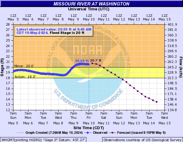
Flood Categories (in feet)
| Major Flood Stage: |
31 |
| Moderate Flood Stage: |
28 |
| Flood Stage: |
20 |
| Action Stage: |
18 |
| Low Stage (in feet): |
-9999 |
Historic Crests
(1) 35.40 ft on 07/31/1993
(2) 32.90 ft on 05/19/1995
(3) 32.50 ft on 10/06/1986
(4) 32.25 ft on 06/01/1844
(5) 31.88 ft on 05/04/2017
(6) 30.90 ft on 07/19/1951
(7) 30.17 ft on 12/30/2015
(8) 30.10 ft on 04/24/1973
(9) 29.60 ft on 09/24/1993
(10) 29.28 ft on 06/08/2019
Show More Historic Crests
(P): Preliminary values subject to further review.
Recent Crests
(1) 21.66 ft on 05/06/2022
(2) 24.33 ft on 06/29/2021
(3) 21.22 ft on 04/13/2021
(4) 24.50 ft on 03/19/2021
(5) 20.51 ft on 06/11/2020
(6) 22.35 ft on 05/31/2020
(7) 22.05 ft on 03/21/2020
(8) 22.83 ft on 01/12/2020
(9) 21.96 ft on 10/12/2019
(10) 20.73 ft on 09/02/2019
Show More Recent Crests
(P): Preliminary values subject to further review.
Low Water Records (1) -3.30 ft on 12/14/1937
(2) -3.20 ft on 01/29/1936
(3) -2.69 ft on 12/31/2022
(4) -2.65 ft on 11/19/2006
(5) -2.30 ft on 01/24/1963
Show More Low Water Records Missouri River At St. Charles (SCLM7)
Return to TopNOTE: River forecasts for this location take into account past precipitation and the precipitation amounts expected approximately 24 hours into the future from the forecast issuance time.
Flood Stage: 25 Feet
Latest Stage: 10.13
Current Warnings/Statements/Advisories:None currently.
Vertical Datum updated from NGVD29 to NAVD88 by gauge owner.
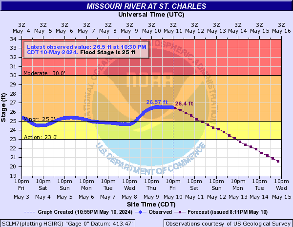
Flood Categories (in feet)
| Major Flood Stage: |
36 |
| Moderate Flood Stage: |
30 |
| Flood Stage: |
25 |
| Action Stage: |
23 |
| Low Stage (in feet): |
-9999 |
Historic Crests
(1) 40.11 ft on 06/24/1844
(2) 40.04 ft on 08/02/1993
(3) 37.50 ft on 10/07/1986
(4) 37.30 ft on 07/20/1951
(5) 36.80 ft on 06/07/1903
(6) 36.60 ft on 05/22/1943
(7) 36.50 ft on 04/29/1944
(8) 36.50 ft on 05/21/1995
(9) 36.40 ft on 04/26/1973
(10) 35.91 ft on 05/05/2017
Show More Historic Crests
(P): Preliminary values subject to further review.
Recent Crests
(1) 25.27 ft on 06/04/2022
(2) 26.84 ft on 05/06/2022
(3) 29.21 ft on 06/29/2021
(4) 26.42 ft on 04/13/2021
(5) 29.09 ft on 03/20/2021
(6) 25.88 ft on 06/07/2020
(7) 27.95 ft on 05/31/2020
(8) 27.11 ft on 03/21/2020
(9) 28.03 ft on 01/12/2020
(10) 27.88 ft on 10/12/2019
Show More Recent Crests
(P): Preliminary values subject to further review.
Low Water Records (1) 3.20 ft on 12/24/1963
(2) 3.45 ft on 12/26/1879
(3) 4.03 ft on 11/28/2006
(4) 4.17 ft on 12/15/2005
(5) 4.18 ft on 01/01/2023
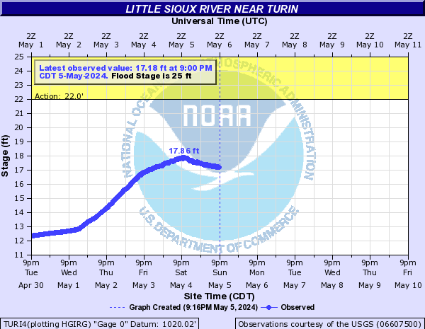
Show More Low Water Records Little Sioux River Near Turin (TURI4)
Return to TopNOTE: River forecasts for this location take into account past precipitation and the precipitation amounts expected approximately 24 hours into the future from the forecast issuance time.
Flood Stage: 25 Feet
Latest Stage: 9.18
Current Warnings/Statements/Advisories:None currently.
Flood Categories (in feet)
| Major Flood Stage: |
34.5 |
| Moderate Flood Stage: |
28 |
| Flood Stage: |
25 |
| Action Stage: |
22 |
| Low Stage (in feet): |
-9999 |
Historic Crests
(1) 29.57 ft on 03/15/2019
(2) 27.44 ft on 02/19/1971
(3) 26.99 ft on 06/22/1996
(4) 26.54 ft on 06/21/1983
(5) 26.47 ft on 03/19/1978
Show More Historic Crests
(P): Preliminary values subject to further review.
Recent Crests
(1) 10.25 ft on 06/05/2022
(2) 9.07 ft on 03/04/2021
(3) 16.02 ft on 02/24/2020
(4) 29.57 ft on 03/15/2019
(5) 23.86 ft on 09/25/2018
Show More Recent Crests
(P): Preliminary values subject to further review.
Low Water Records
Currently none available.
Soldier River At Pisgah (PSGI4)
Return to TopNOTE: River forecasts for this location take into account past precipitation and the precipitation amounts expected approximately 24 hours into the future from the forecast issuance time.
Flood Stage: 28 Feet
Latest Stage: 2.5
Current Warnings/Statements/Advisories:None currently.
Flood Categories (in feet)
| Major Flood Stage: |
30 |
| Moderate Flood Stage: |
29 |
| Flood Stage: |
28 |
| Action Stage: |
26 |
| Low Stage (in feet): |
-9999 |
Historic Crests
(1) 28.87 ft on 07/17/1996
(2) 28.20 ft on 06/12/1950
(3) 27.56 ft on 07/09/1993
(4) 27.46 ft on 06/17/1951
(5) 27.26 ft on 03/13/2019
Show More Historic Crests
(P): Preliminary values subject to further review.
Recent Crests
(1) 13.69 ft on 02/27/2023
(2) 4.93 ft on 02/18/2022
(3) 5.27 ft on 07/11/2021
(4) 7.33 ft on 06/19/2020
(5) 27.26 ft on 03/13/2019
Show More Recent Crests
(P): Preliminary values subject to further review.
Low Water Records
Currently none available.
Boyer River At Logan (LGNI4)
Return to TopNOTE: River forecasts for this location take into account past precipitation and the precipitation amounts expected approximately 24 hours into the future from the forecast issuance time.
Flood Stage: 21 Feet
Latest Stage: 3.49
Current Warnings/Statements/Advisories:None currently.
Flood Categories (in feet)
| Major Flood Stage: |
25 |
| Moderate Flood Stage: |
22 |
| Flood Stage: |
21 |
| Action Stage: |
19 |
| Low Stage (in feet): |
-9999 |
Historic Crests
(1) 25.33 ft on 03/13/2019
(2) 25.22 ft on 03/01/1965
(3) 24.75 ft on 06/08/2008
(4) 23.87 ft on 07/17/1996
(5) 23.02 ft on 06/21/1996
Show More Historic Crests
(P): Preliminary values subject to further review.
Recent Crests
(1) 6.12 ft on 07/08/2022
(2) 6.45 ft on 07/11/2021
(3) 11.11 ft on 06/10/2020
(4) 25.33 ft on 03/13/2019
(5) 14.70 ft on 08/20/2018
Show More Recent Crests
(P): Preliminary values subject to further review.
Low Water Records
Currently none available.
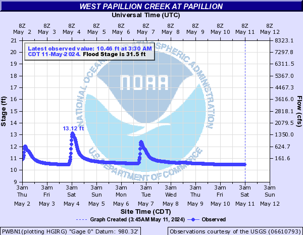
West Papillion Creek At Papillion (PWBN1)
Return to TopFlood Stage: 31.5 Feet
Latest Stage: 10.35
Current Warnings/Statements/Advisories:None currently.
Flood Categories (in feet)
| Major Flood Stage: |
35.5 |
| Moderate Flood Stage: |
33 |
| Flood Stage: |
31.5 |
| Action Stage: |
26.5 |
| Low Stage (in feet): |
-9999 |
Historic Crests
(1) 26.59 ft on 06/21/2014
(2) 24.50 ft on 08/24/2016
(3) 23.03 ft on 08/31/2021
(4) 22.68 ft on 05/07/2015
(5) 21.34 ft on 03/13/2019
Show More Historic Crests
(P): Preliminary values subject to further review.
Recent Crests
(1) 13.77 ft on 08/02/2023
(2) 15.94 ft on 06/05/2022
(3) 23.03 ft on 08/31/2021
(4) 14.97 ft on 06/09/2020
(5) 21.34 ft on 03/13/2019
Show More Recent Crests
(P): Preliminary values subject to further review.
Low Water Records
Currently none available.
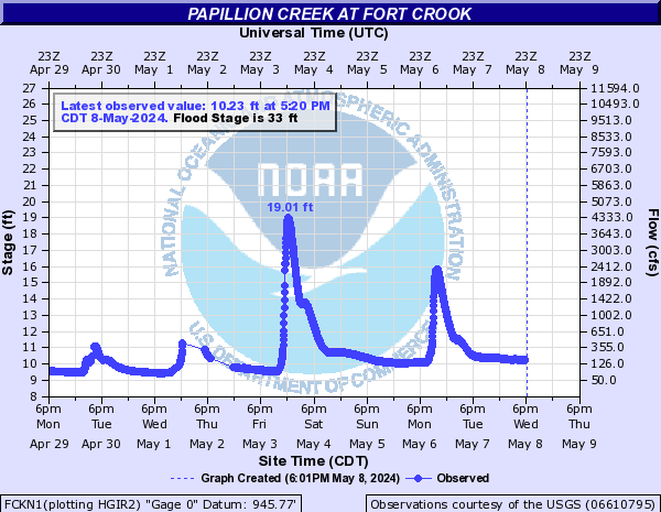
Papillion Creek At Fort Crook (FCKN1)
Return to TopFlood Stage: 33 Feet
Latest Stage: 9.13
Current Warnings/Statements/Advisories:None currently.
Flood Categories (in feet)
| Major Flood Stage: |
39 |
| Moderate Flood Stage: |
37 |
| Flood Stage: |
33 |
| Action Stage: |
27 |
| Low Stage (in feet): |
-9999 |
Historic Crests
(1) 36.21 ft on 06/21/2014
(2) 34.42 ft on 06/12/2008
(3) 32.02 ft on 03/13/2019
(4) 31.85 ft on 05/07/2015
(5) 30.74 ft on 05/06/2007
Show More Historic Crests
(P): Preliminary values subject to further review.
Recent Crests
(1) 21.78 ft on 08/02/2023
(2) 23.92 ft on 06/15/2022
(3) 27.92 ft on 08/31/2021
(4) 21.03 ft on 06/10/2020
(5) 32.02 ft on 03/13/2019
Show More Recent Crests
(P): Preliminary values subject to further review.
Low Water Records
Currently none available.
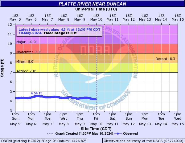
Platte River Near Duncan (DNCN1)
Return to TopNOTE: River forecasts for this location take into account past precipitation and the precipitation amounts expected approximately 24 hours into the future from the forecast issuance time.
Flood Stage: 8 Feet
Latest Stage: 3.63
Current Warnings/Statements/Advisories:None currently.
Flood Categories (in feet)
| Major Flood Stage: |
10 |
| Moderate Flood Stage: |
9 |
| Flood Stage: |
8 |
| Action Stage: |
7 |
| Low Stage (in feet): |
-9999 |
Historic Crests
(1) 8.28 ft on 06/07/1935
(2) 8.07 ft on 06/14/1983
(3) 8.04 ft on 03/16/2019
(4) 8.00 ft on 01/22/1985
(5) 7.96 ft on 06/18/1983
Show More Historic Crests
(P): Preliminary values subject to further review.
Recent Crests
(1) 5.32 ft on 07/04/2023
(2) 4.70 ft on 11/30/2022
(3) 5.94 ft on 03/15/2021
(4) 6.73 ft on 05/27/2020
(5) 8.04 ft on 03/16/2019
Show More Recent Crests
(P): Preliminary values subject to further review.
Low Water Records
(1) -0.32 ft on 09/12/2012
Platte River At North Bend (NBDN1)
Return to TopNOTE: River forecasts for this location take into account past precipitation and the precipitation amounts expected approximately 24 hours into the future from the forecast issuance time.
Flood Stage: 8 Feet
Latest Stage: 3.07
Current Warnings/Statements/Advisories:None currently.
Flood Categories (in feet)
| Major Flood Stage: |
11.5 |
| Moderate Flood Stage: |
10 |
| Flood Stage: |
8 |
| Action Stage: |
7 |
| Low Stage (in feet): |
-9999 |
Historic Crests
(1) 15.55 ft on 03/19/1978
(2) 12.24 ft on 02/20/1971
(3) 11.96 ft on 03/15/2019
(4) 10.97 ft on 03/08/1993
(5) 10.89 ft on 03/10/2010
Show More Historic Crests
(P): Preliminary values subject to further review.
Recent Crests
(1) 5.72 ft on 02/09/2022
(2) 7.37 ft on 02/28/2021
(3) 7.86 ft on 02/15/2020
(4) 11.96 ft on 03/15/2019
(5) 7.80 ft on 03/03/2018
Show More Recent Crests
(P): Preliminary values subject to further review.
Low Water Records
(1) 1.50 ft on 07/23/2012
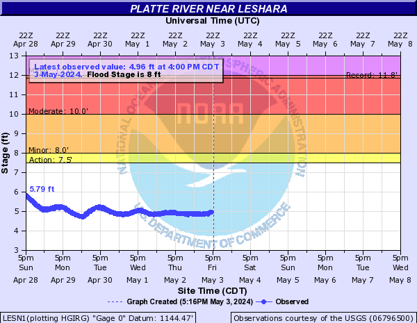
Platte River Near Leshara (LESN1)
Return to TopNOTE: River forecasts for this location take into account past precipitation and the precipitation amounts expected approximately 24 hours into the future from the forecast issuance time.
Flood Stage: 8 Feet
Latest Stage: 4.46
Current Warnings/Statements/Advisories:None currently.
Flood Categories (in feet)
| Major Flood Stage: |
12 |
| Moderate Flood Stage: |
10 |
| Flood Stage: |
8 |
| Action Stage: |
7.5 |
| Low Stage (in feet): |
-9999 |
Historic Crests
(1) 11.84 ft on 02/09/1996
(2) 11.47 ft on 03/15/2019
(3) 9.55 ft on 02/03/2000
(4) 8.30 ft on 05/31/2008
(5) 8.30 ft on 02/22/1997
Show More Historic Crests
(P): Preliminary values subject to further review.
Recent Crests
(1) 6.36 ft on 02/10/2022
(2) 6.96 ft on 03/15/2021
(3) 7.20 ft on 02/05/2020
(4) 11.47 ft on 03/15/2019
(5) 7.29 ft on 06/27/2018
Show More Recent Crests
(P): Preliminary values subject to further review.
Low Water Records
(1) 2.82 ft on 08/16/2012
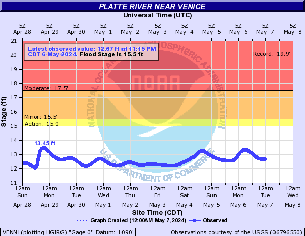
Platte River Near Venice (VENN1)
Return to TopFlood Stage: 15.5 Feet
Latest Stage: 11.97
Current Warnings/Statements/Advisories:None currently.
Flood Categories (in feet)
| Major Flood Stage: |
22 |
| Moderate Flood Stage: |
17.5 |
| Flood Stage: |
15.5 |
| Action Stage: |
15 |
| Low Stage (in feet): |
-9999 |
Historic Crests
(1) 19.92 ft on 03/15/2019
(2) 18.18 ft on 03/11/2010
(3) 16.41 ft on 03/11/2014
(4) 16.05 ft on 02/17/2011
(5) 16.01 ft on 01/29/2015
Show More Historic Crests
(P): Preliminary values subject to further review.
Recent Crests
(1) 13.19 ft on 02/09/2022
(2) 14.27 ft on 03/15/2021
(3) 14.72 ft on 05/27/2020
(4) 19.92 ft on 03/15/2019
(5) 15.63 ft on 03/03/2018
Show More Recent Crests
(P): Preliminary values subject to further review.
Low Water Records
Currently none available.
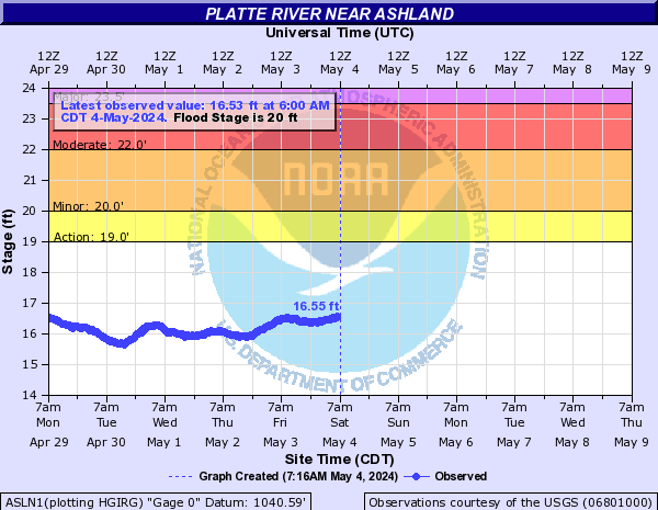
Platte River Near Ashland (ASLN1)
Return to TopNOTE: River forecasts for this location take into account past precipitation and the precipitation amounts expected approximately 24 hours into the future from the forecast issuance time.
Flood Stage: 20 Feet
Latest Stage: 16.12
Current Warnings/Statements/Advisories:None currently.
Flood Categories (in feet)
| Major Flood Stage: |
23.5 |
| Moderate Flood Stage: |
22 |
| Flood Stage: |
20 |
| Action Stage: |
19 |
| Low Stage (in feet): |
-9999 |
Historic Crests
(1) 24.32 ft on 03/16/2019
(2) 23.05 ft on 02/20/1997
(3) 21.98 ft on 02/17/2011
(4) 21.45 ft on 07/25/1993
(5) 21.39 ft on 03/15/2001
Show More Historic Crests
(P): Preliminary values subject to further review.
Recent Crests
(1) 17.22 ft on 03/01/2023
(2) 17.04 ft on 02/10/2022
(3) 18.31 ft on 03/15/2021
(4) 18.04 ft on 05/27/2020
(5) 24.32 ft on 03/16/2019
Show More Recent Crests
(P): Preliminary values subject to further review.
Low Water Records
(1) 13.01 ft on 08/18/2012
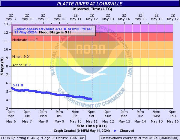
Platte River At Louisville (LOUN1)
Return to TopNOTE: River forecasts for this location take into account past precipitation and the precipitation amounts expected approximately 24 hours into the future from the forecast issuance time.
Flood Stage: 9 Feet
Latest Stage: 3.89
Current Warnings/Statements/Advisories:None currently.
Flood Categories (in feet)
| Major Flood Stage: |
12 |
| Moderate Flood Stage: |
11 |
| Flood Stage: |
9 |
| Action Stage: |
8 |
| Low Stage (in feet): |
-9999 |
Historic Crests
(1) 13.82 ft on 03/16/2019
(2) 12.45 ft on 03/30/1960
(3) 11.90 ft on 07/25/1993
(4) 11.47 ft on 03/10/1993
(5) 11.35 ft on 06/14/1984
Show More Historic Crests
(P): Preliminary values subject to further review.
Recent Crests
(1) 5.53 ft on 02/10/2022
(2) 7.43 ft on 03/15/2021
(3) 7.00 ft on 05/27/2020
(4) 8.99 ft on 05/29/2019
(5) 13.82 ft on 03/16/2019
Show More Recent Crests
(P): Preliminary values subject to further review.
Low Water Records
(1) 1.12 ft on 08/06/2012
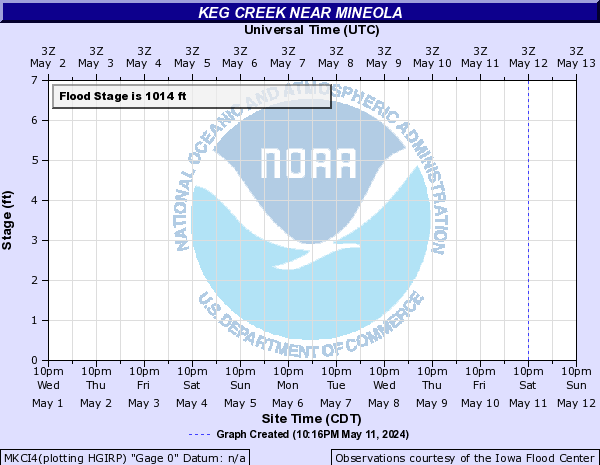
Keg Creek Near Mineola (MKCI4)
Return to TopFlood Stage: 0 KCFS
Latest Flow: n/a
Current Warnings/Statements/Advisories:None currently.
Flood Categories (in feet)
| Major Flood Stage: |
1019 |
| Moderate Flood Stage: |
1016.42 |
| Flood Stage: |
1014 |
| Action Stage: |
1013 |
| Low Stage (in feet): |
-9999 |
Historic Crests
Currently none available.
Recent Crests
Currently none available.
Low Water Records
Currently none available.
()
Return to TopFlood Flow: Not available
Latest Flow: n/a
Current Warnings/Statements/Advisories:None currently.
Flood Categories (in feet)
| Major Flood Stage: |
|
| Moderate Flood Stage: |
|
| Flood Stage: |
|
| Action Stage: |
|
| Low Stage (in feet): |
0 |
Historic Crests
Currently none available.
Recent Crests
Currently none available.
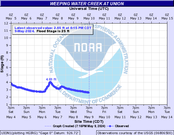
Weeping Water Creek At Union (UION1)
Return to TopNOTE: River forecasts for this location take into account past precipitation and the precipitation amounts expected approximately 24 hours into the future from the forecast issuance time.
Flood Stage: 25 Feet
Latest Stage: 2.26
Current Warnings/Statements/Advisories:None currently.
Flood Categories (in feet)
| Major Flood Stage: |
30 |
| Moderate Flood Stage: |
28 |
| Flood Stage: |
25 |
| Action Stage: |
23 |
| Low Stage (in feet): |
-9999 |
Historic Crests
(1) 30.97 ft on 07/23/1993
(2) 29.98 ft on 06/21/2010
(3) 29.80 ft on 05/09/1950
(4) 29.53 ft on 06/13/1984
(5) 29.20 ft on 07/26/1990
Show More Historic Crests
(P): Preliminary values subject to further review.
Recent Crests
(1) 20.57 ft on 08/26/2023
(2) 20.20 ft on 05/26/2022
(3) 19.38 ft on 06/25/2021
(4) 17.66 ft on 07/29/2020
(5) 26.38 ft on 03/13/2019
Show More Recent Crests
(P): Preliminary values subject to further review.
Low Water Records
Currently none available.
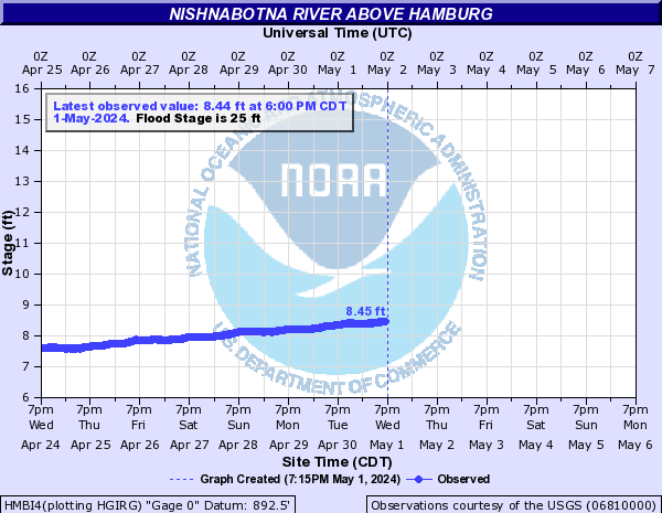
Nishnabotna River Above Hamburg (HMBI4)
Return to TopNOTE: River forecasts for this location take into account past precipitation and the precipitation amounts expected approximately 24 hours into the future from the forecast issuance time.
Flood Stage: 25 Feet
Latest Stage: 7.77
Current Warnings/Statements/Advisories:None currently.
Flood Categories (in feet)
| Major Flood Stage: |
33 |
| Moderate Flood Stage: |
27.5 |
| Flood Stage: |
25 |
| Action Stage: |
23 |
| Low Stage (in feet): |
-9999 |
Historic Crests
(1) 33.18 ft on 06/17/1998
(2) 32.44 ft on 05/08/2007
(3) 31.07 ft on 03/16/2019
(4) 30.56 ft on 07/25/1993
(5) 29.19 ft on 06/14/2008
Show More Historic Crests
(P): Preliminary values subject to further review.
Recent Crests
(1) 18.72 ft on 02/28/2023
(2) 18.09 ft on 06/08/2022
(3) 13.21 ft on 10/25/2021
(4) 17.94 ft on 05/27/2020
(5) 31.07 ft on 03/16/2019
Show More Recent Crests
(P): Preliminary values subject to further review.
Low Water Records
Currently none available.
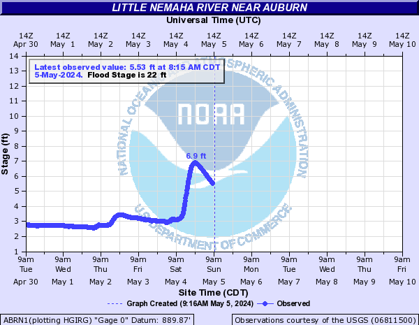
Little Nemaha River Near Auburn (ABRN1)
Return to TopNOTE: River forecasts for this location take into account past precipitation and the precipitation amounts expected approximately 24 hours into the future from the forecast issuance time.
Flood Stage: 22 Feet
Latest Stage: 2.41
Current Warnings/Statements/Advisories:None currently.
Flood Categories (in feet)
| Major Flood Stage: |
27 |
| Moderate Flood Stage: |
23 |
| Flood Stage: |
22 |
| Action Stage: |
20 |
| Low Stage (in feet): |
-9999 |
Historic Crests
(1) 27.65 ft on 05/09/1950
(2) 26.49 ft on 07/24/1993
(3) 25.72 ft on 05/05/2001
(4) 25.02 ft on 07/25/1992
(5) 24.96 ft on 06/02/1951
Show More Historic Crests
(P): Preliminary values subject to further review.
Recent Crests
(1) 13.40 ft on 07/30/2023
(2) 22.64 ft on 05/26/2022
(3) 19.92 ft on 03/15/2021
(4) 18.89 ft on 06/27/2020
(5) 24.50 ft on 05/24/2019
Show More Recent Crests
(P): Preliminary values subject to further review.
Low Water Records
Currently none available.
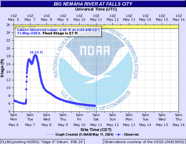
Big Nemaha River At Falls City (FLLN1)
Return to TopNOTE: River forecasts for this location take into account past precipitation and the precipitation amounts expected approximately 24 hours into the future from the forecast issuance time.
Flood Stage: 27 Feet
Latest Stage: 3.75
Current Warnings/Statements/Advisories:None currently.
Flood Categories (in feet)
| Major Flood Stage: |
36 |
| Moderate Flood Stage: |
30 |
| Flood Stage: |
27 |
| Action Stage: |
25 |
| Low Stage (in feet): |
-9999 |
Historic Crests
(1) 34.40 ft on 10/11/1973
(2) 32.77 ft on 07/06/1993
(3) 31.90 ft on 06/29/1965
(4) 31.80 ft on 06/02/1949
(5) 31.59 ft on 05/29/2019
Show More Historic Crests
(P): Preliminary values subject to further review.
Recent Crests
(1) 18.58 ft on 05/26/2022
(2) 30.99 ft on 06/25/2021
(3) 22.90 ft on 07/30/2020
(4) 31.59 ft on 05/29/2019
(5) 26.51 ft on 10/09/2018
Show More Recent Crests
(P): Preliminary values subject to further review.
Low Water Records
Currently none available.
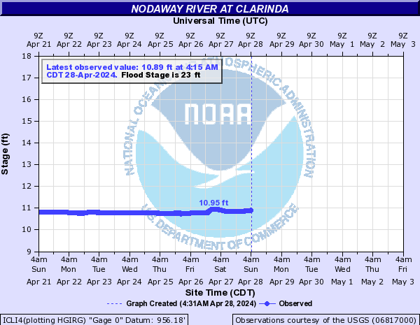
Nodaway River At Clarinda (ICLI4)
Return to TopNOTE: River forecasts for this location take into account past precipitation and the precipitation amounts expected approximately 24 hours into the future from the forecast issuance time.
Flood Stage: 23 Feet
Latest Stage: 11.12
Current Warnings/Statements/Advisories:None currently.
Flood Categories (in feet)
| Major Flood Stage: |
29 |
| Moderate Flood Stage: |
26 |
| Flood Stage: |
23 |
| Action Stage: |
21 |
| Low Stage (in feet): |
-9999 |
Historic Crests
(1) 26.70 ft on 05/24/2019
(2) 26.61 ft on 06/05/2008
Show More Historic Crests
(P): Preliminary values subject to further review.
Recent Crests
Currently none available.
Low Water Records
Currently none available.