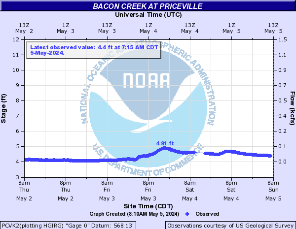
Bacon Creek (Click on an image to go to hydrograph webpage)
PCVK2:
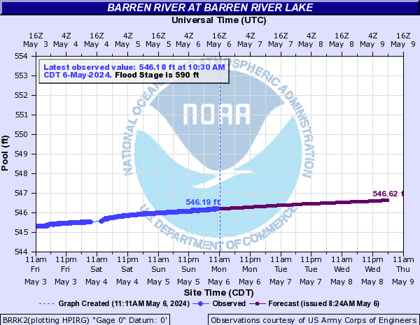
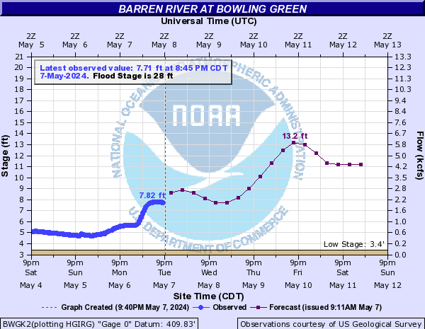
Barren River (Click on an image to go to hydrograph webpage)
BRRK2:
BWGK2:
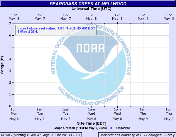
Beargrass Creek (Click on an image to go to hydrograph webpage)
MLWK2:
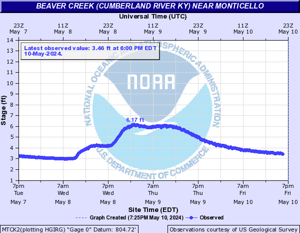
Beaver Creek (Cumberland River KY) (Click on an image to go to hydrograph webpage)
MTCK2:
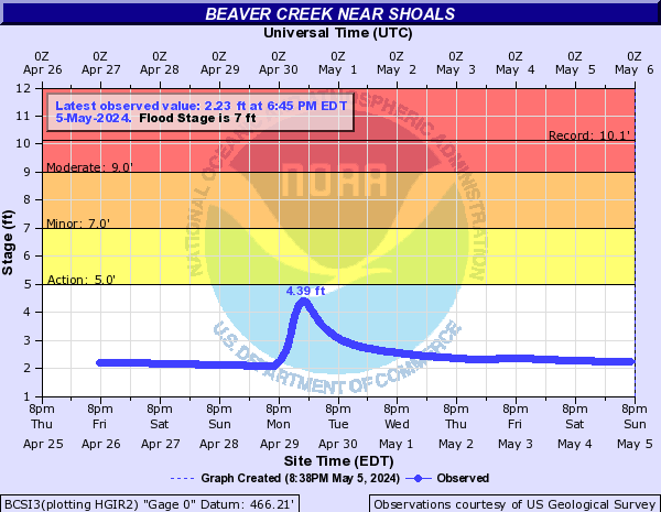
Beaver Creek (IN) (Click on an image to go to hydrograph webpage)
BCSI3:
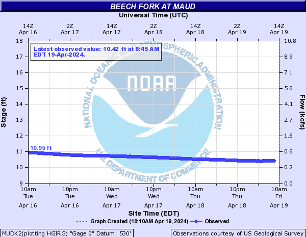
Beech Fork (Click on an image to go to hydrograph webpage)
MUDK2:
BTDK2:

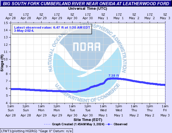
Big South Fork Cumberland River (Click on an image to go to hydrograph webpage)
LTWT1:
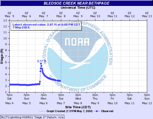
Bledsoe Creek (Click on an image to go to hydrograph webpage)
BLCT1:
Blue River (IN) (Click on an image to go to hydrograph webpage)
FRDI3:

WHCI3:

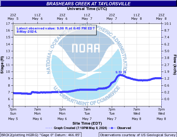
Brashears Creek (Click on an image to go to hydrograph webpage)
BRCK2:
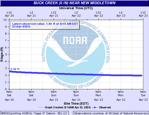
Buck Creek (S IN) (Click on an image to go to hydrograph webpage)
NMDI3:
Cane Run Creek (Click on an image to go to hydrograph webpage)
DLPK2:

HLSK2:

Caney Creek (KY) (Click on an image to go to hydrograph webpage)
HSBK2:

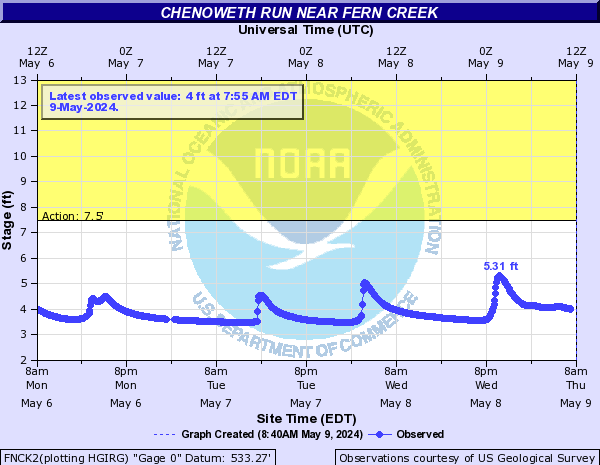
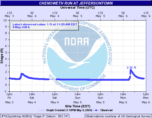
Chenoweth Run (Click on an image to go to hydrograph webpage)
FNCK2:
JFTK2:
Clear Fork (Click on an image to go to hydrograph webpage)
SXTK2:

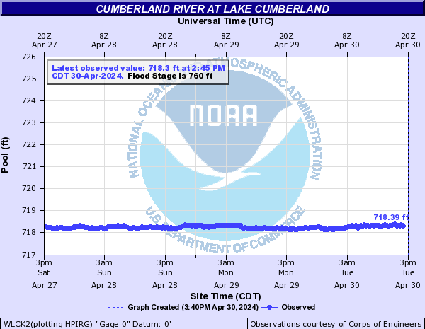
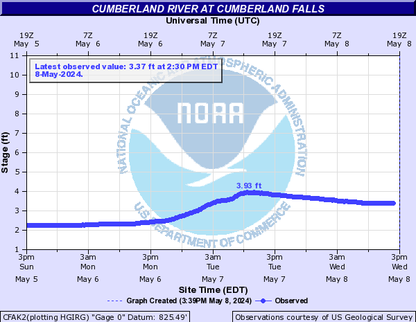
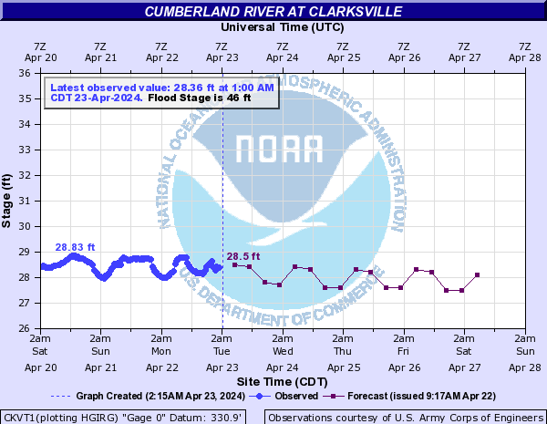
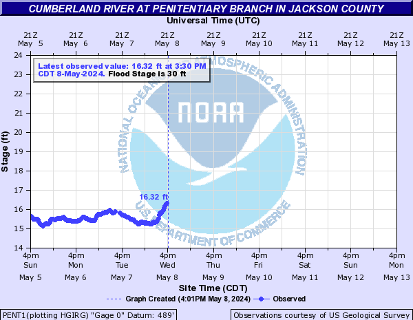
Cumberland River (Click on an image to go to hydrograph webpage)
WLCK2:
BRKK2:

PVLK2:

BBVK2:

WLBK2:

CFAK2:
CLAT1:

CKVT1:
PENT1:
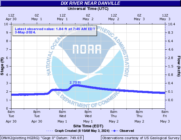
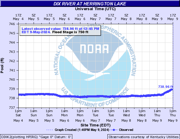
Dix River (Click on an image to go to hydrograph webpage)
DNVK2:
DIXK2:
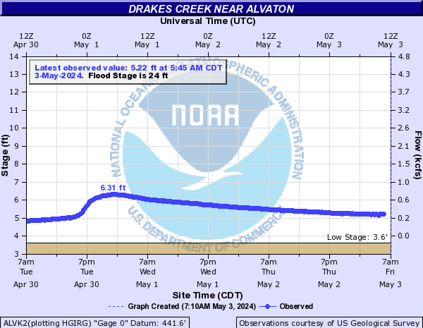
Drakes Creek (Click on an image to go to hydrograph webpage)
ALVK2:
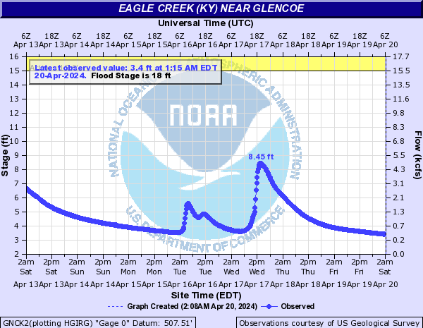
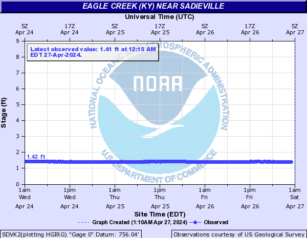
Eagle Creek (KY) (Click on an image to go to hydrograph webpage)
GNCK2:
SDVK2:
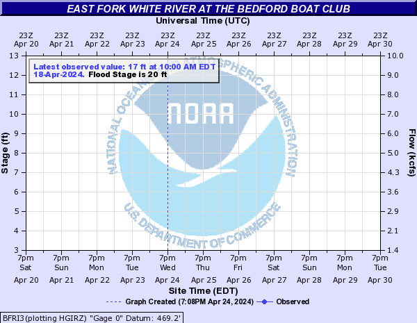
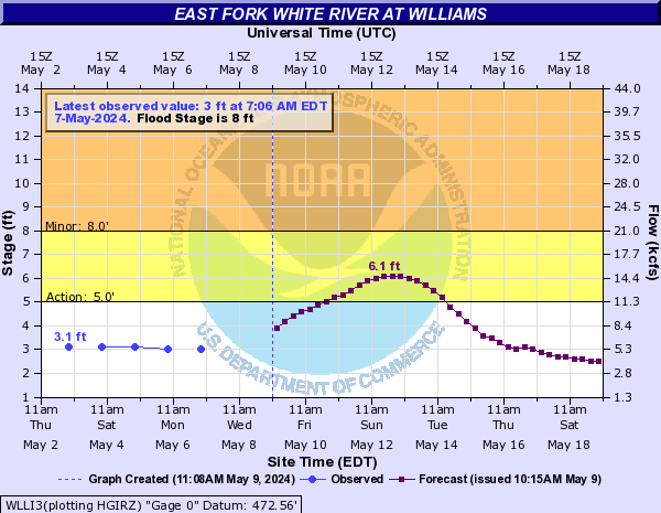
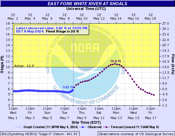
East Fork White River (Click on an image to go to hydrograph webpage)
SERI3:

SPKI3:
BEDI3:

BFRI3:
WLLI3:
SHLI3:
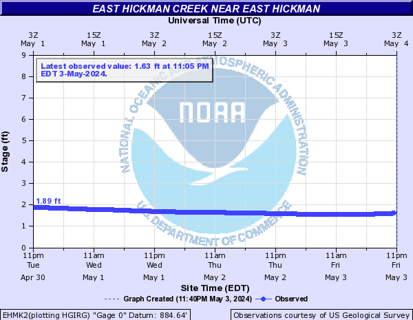
East Hickman Creek (Click on an image to go to hydrograph webpage)
EHMK2:
Elkhorn Creek (Click on an image to go to hydrograph webpage)
YNTK2:

FTSK2:

PKMK2:

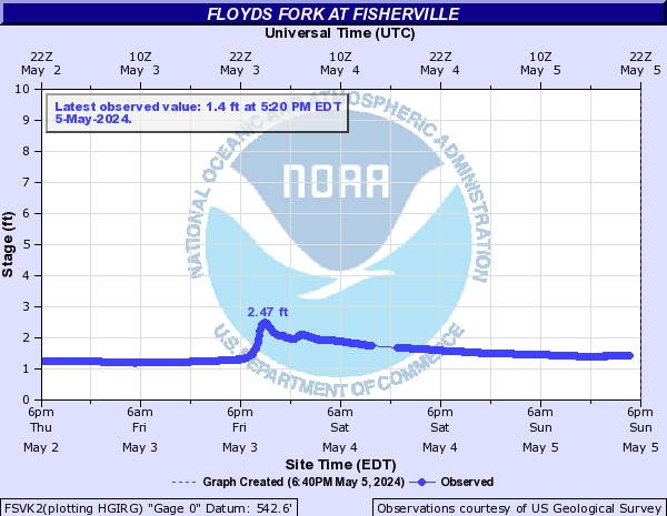
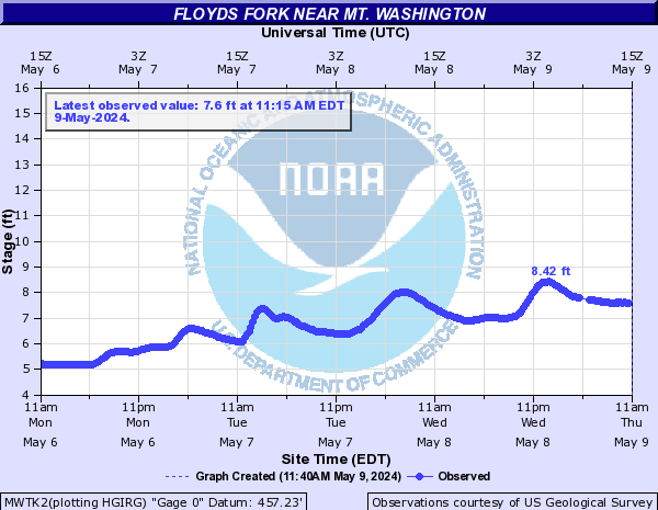
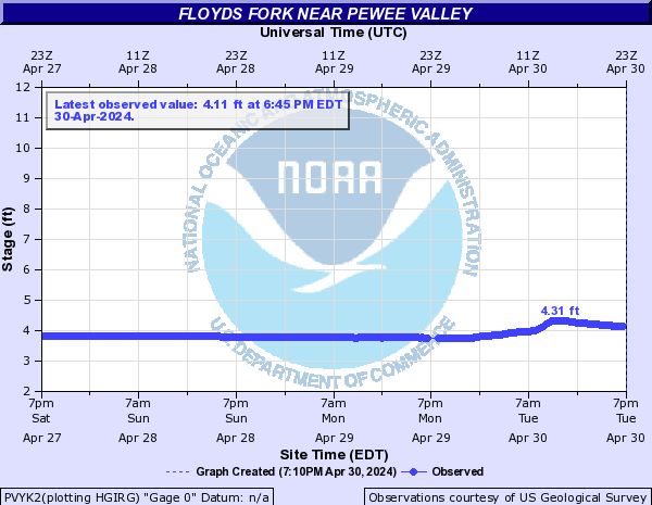
Floyds Fork (Click on an image to go to hydrograph webpage)
FSVK2:
MWTK2:
PVYK2:
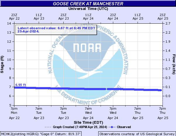
Goose Creek (Click on an image to go to hydrograph webpage)
MCHK2:
Goose Creek (C KY) (Click on an image to go to hydrograph webpage)
LYDK2:

GNWK2:

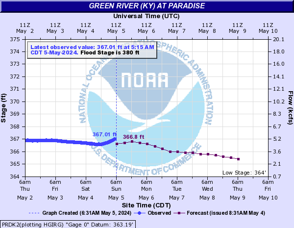
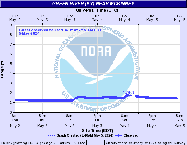
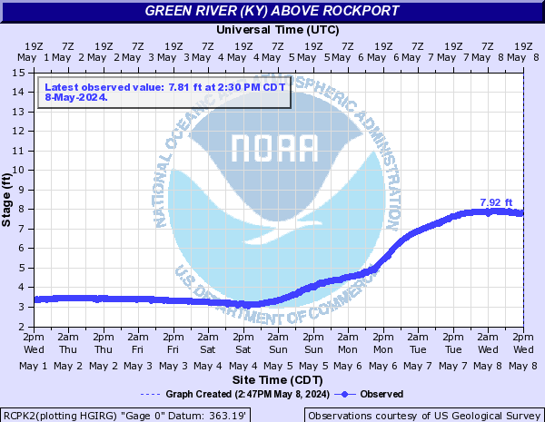
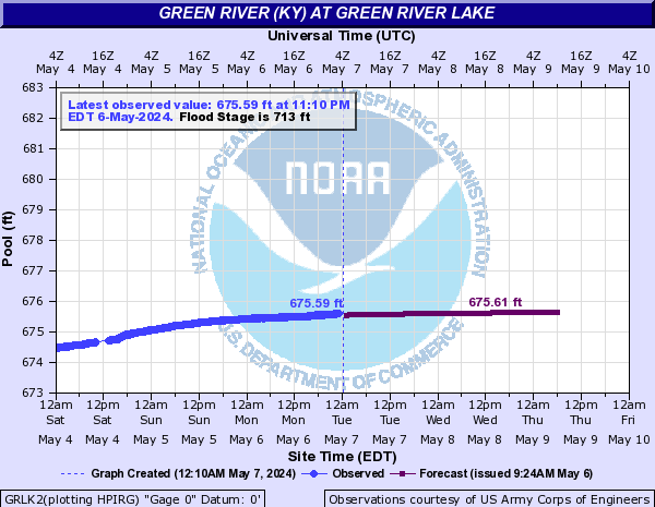
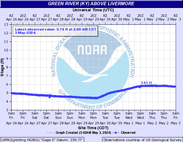
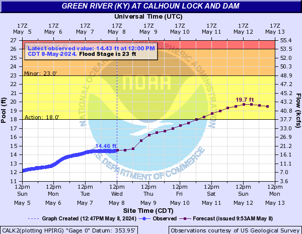
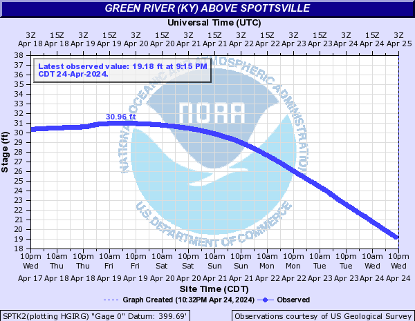
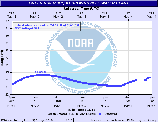
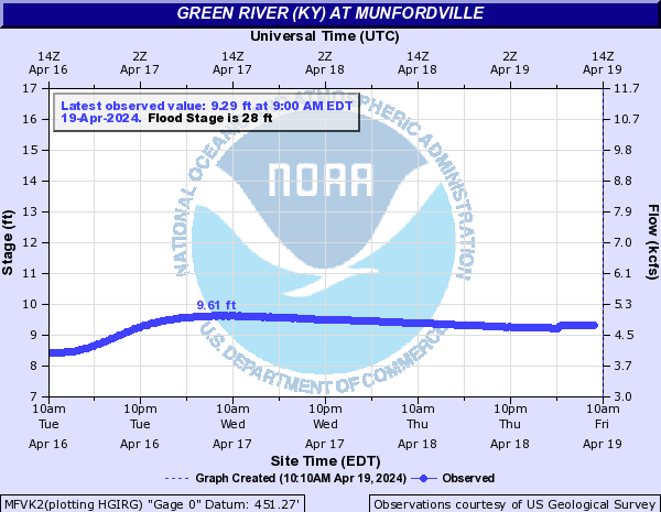
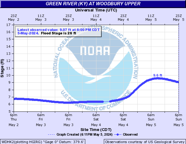
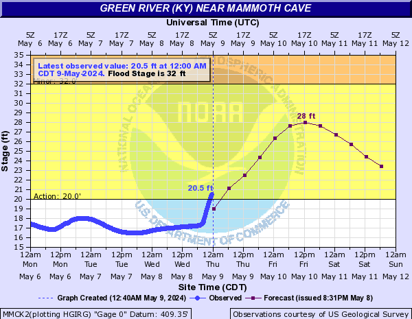
Green River (KY) (Click on an image to go to hydrograph webpage)
PRDK2:
MCKK2:
RCPK2:
GRLK2:
LVMK2:
GNSK2:

CALK2:
SPTK2:
BNWK2:
MFVK2:
WDHK2:
MMCK2:
RCHK2:

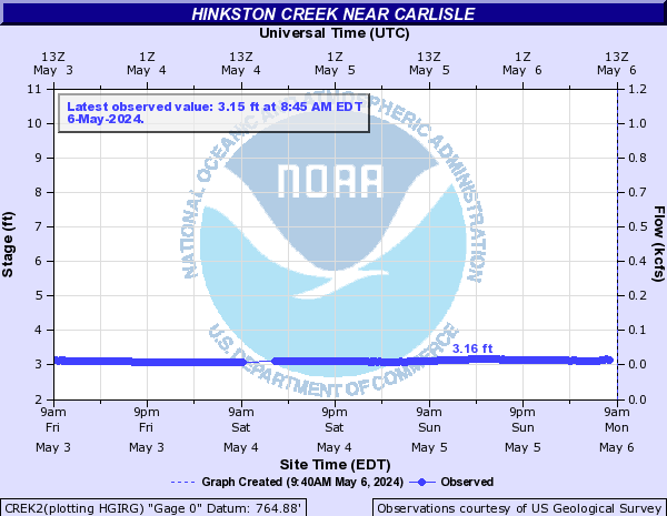
Hinkston Creek (Click on an image to go to hydrograph webpage)
CREK2:
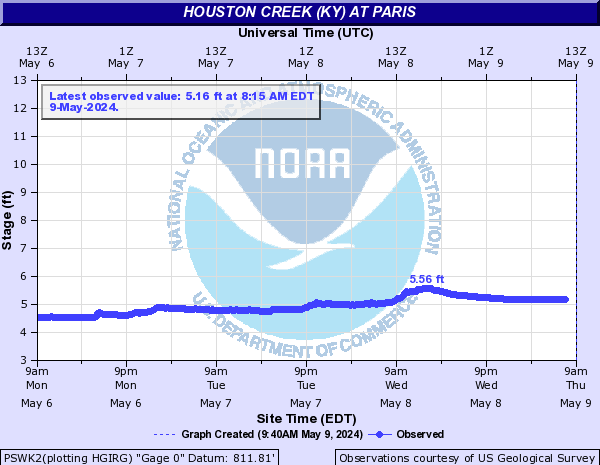
Houston Creek (KY) (Click on an image to go to hydrograph webpage)
PSWK2:
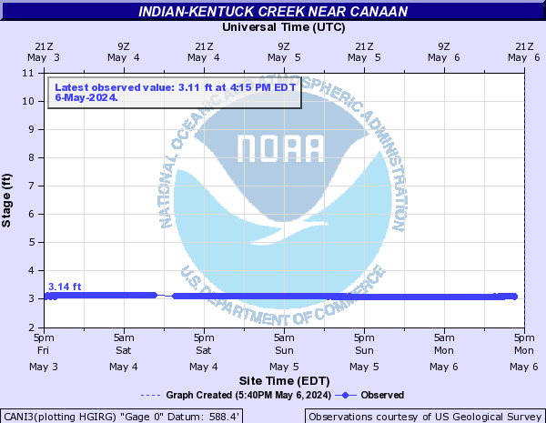
Indian-Kentuck Creek (Click on an image to go to hydrograph webpage)
CANI3:
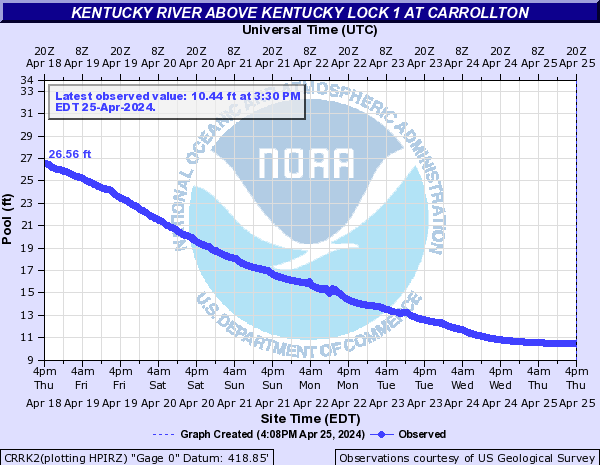
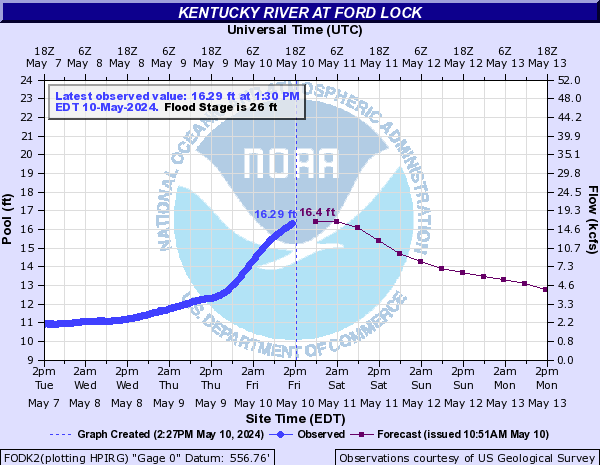
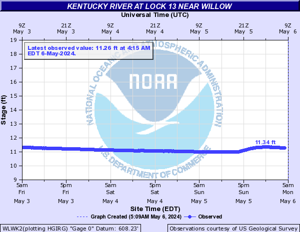
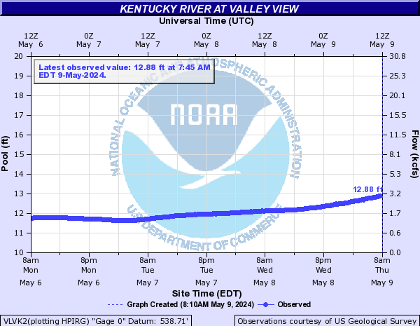
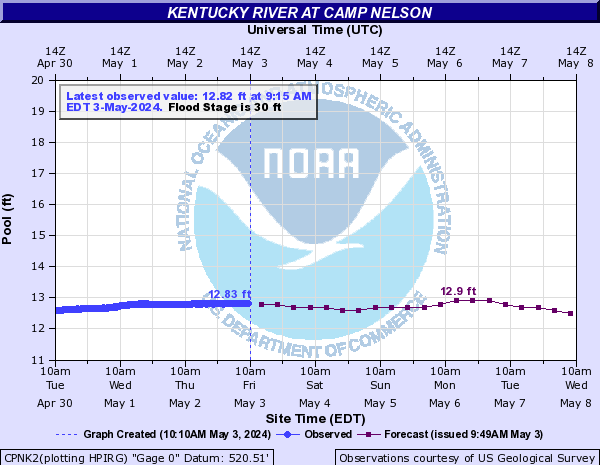
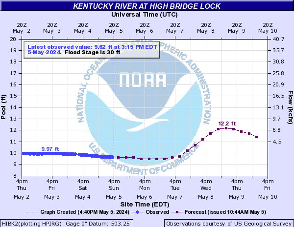
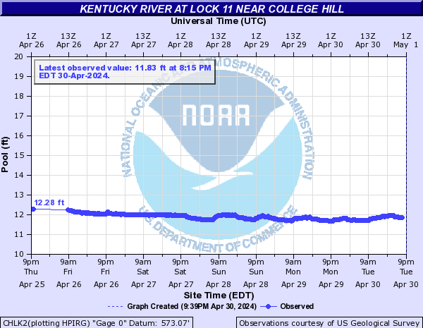
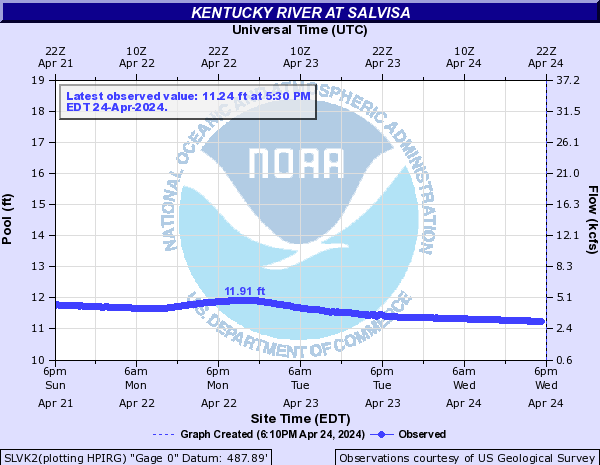
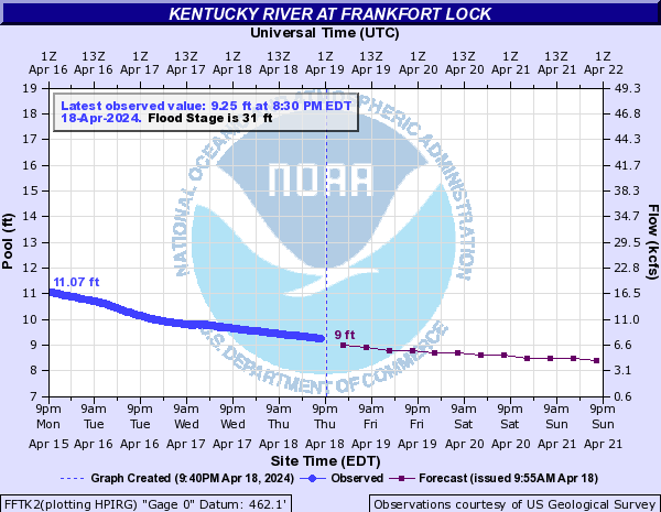
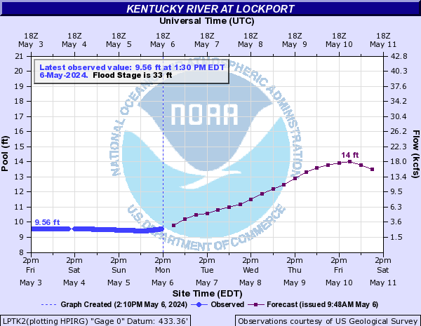
Kentucky River (Click on an image to go to hydrograph webpage)
HLDK2:

CRRK2:
FODK2:
WLWK2:
VLVK2:
RAVK2:

CPNK2:
HIBK2:
CHLK2:
SLVK2:
TYRK2:

FFTK2:
GSTK2:

LPTK2:
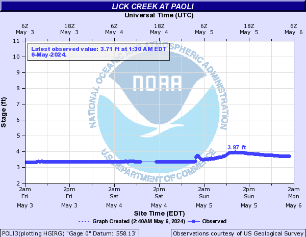
Lick Creek (Click on an image to go to hydrograph webpage)
POLI3:
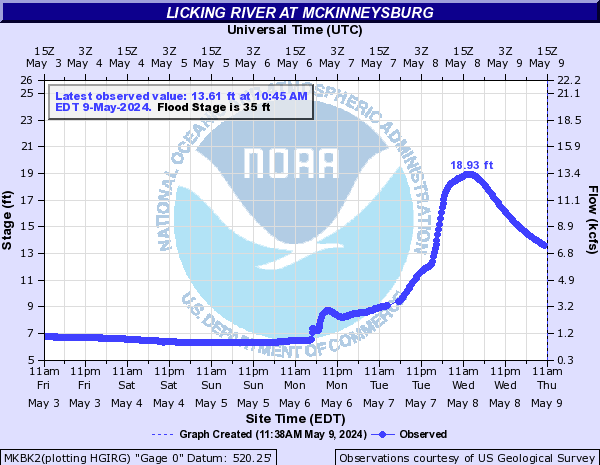
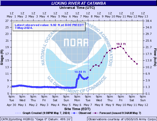
Licking River (Click on an image to go to hydrograph webpage)
MKBK2:
BLSK2:

FLMK2:

CATK2:
BTLK2:
VLIK2:

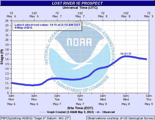
Lost River (IN) (Click on an image to go to hydrograph webpage)
PSPI3:
Lynn Camp Creek (Click on an image to go to hydrograph webpage)
CORK2:

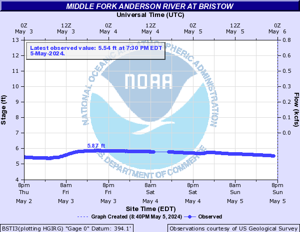
Middle Fork Anderson River (Click on an image to go to hydrograph webpage)
BSTI3:
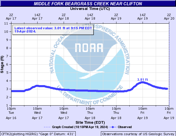
Middle Fork Beargrass Creek (Click on an image to go to hydrograph webpage)
STMK2:

CFTK2:
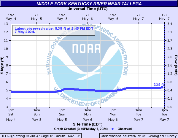
Middle Fork Kentucky River (Click on an image to go to hydrograph webpage)
TLLK2:
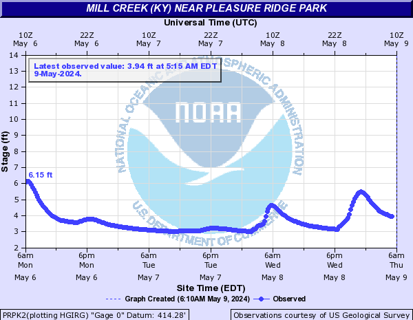
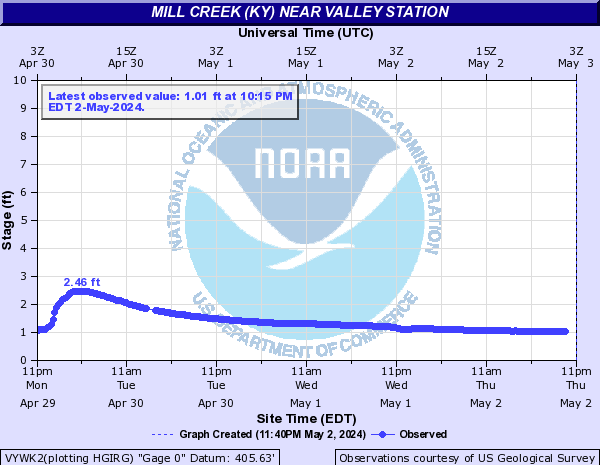
Mill Creek (KY) (Click on an image to go to hydrograph webpage)
PRPK2:
VYWK2:
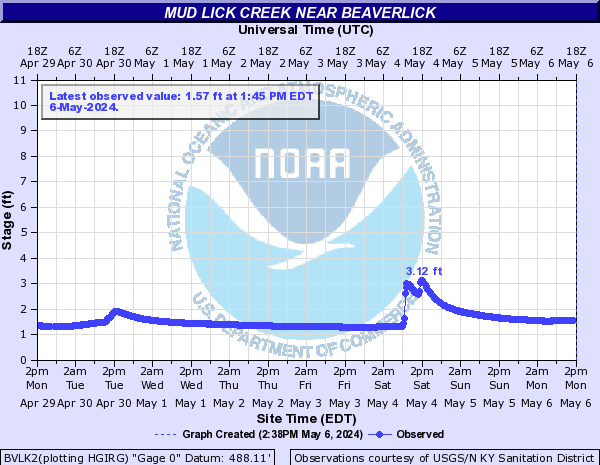
Mud Lick Creek (Click on an image to go to hydrograph webpage)
BVLK2:
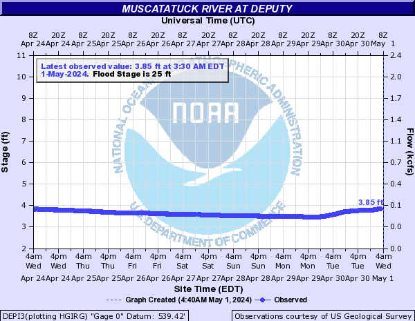
Muscatatuck River (Click on an image to go to hydrograph webpage)
WHLI3:
DEPI3:
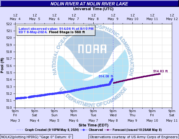
Nolin River (Click on an image to go to hydrograph webpage)
HGVK2:

WHMK2:

NOLK2:
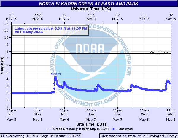
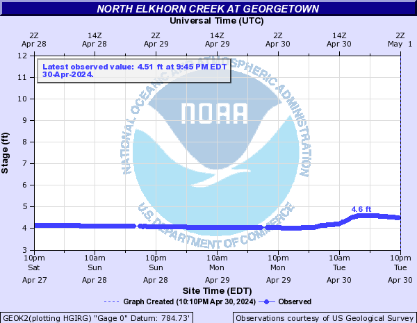
North Elkhorn Creek (Click on an image to go to hydrograph webpage)
ELPK2:
GEOK2:
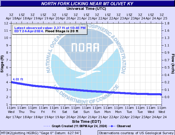
North Fork Licking River (Click on an image to go to hydrograph webpage)
MTOK2:
Northern Ditch (Click on an image to go to hydrograph webpage)
OKLK2:

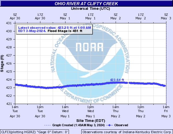
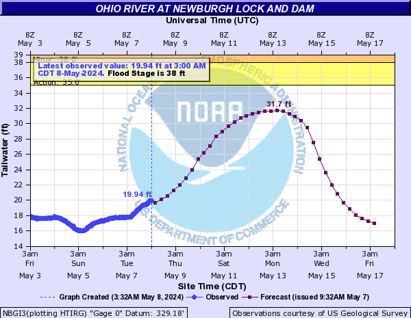
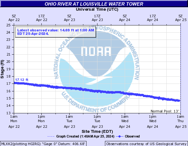
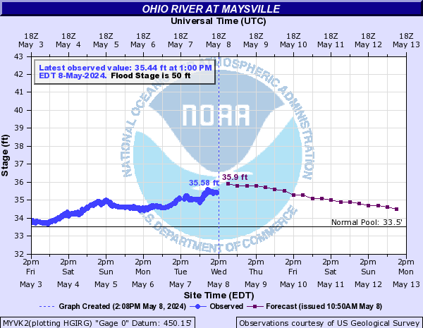
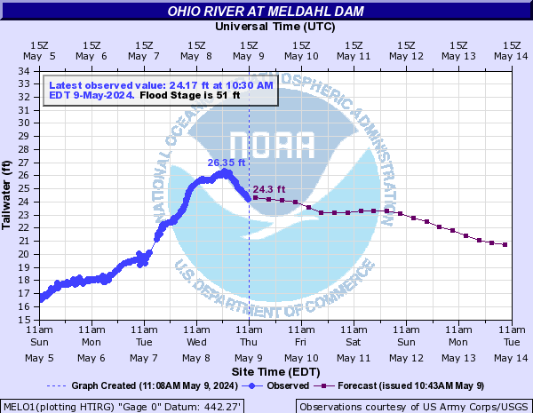
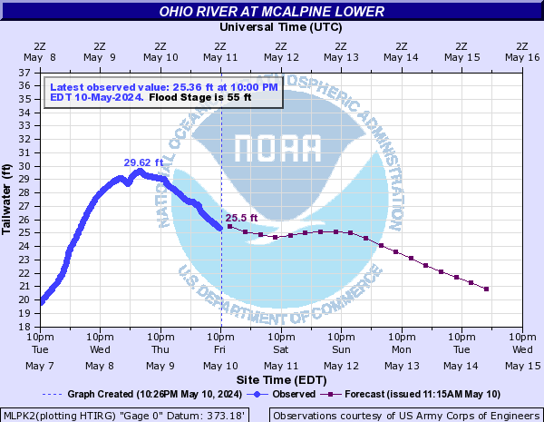
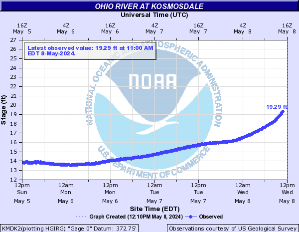
Ohio River (Click on an image to go to hydrograph webpage)
OWBK2:

CLFI3:
NBGI3:
MLXK2:
MYVK2:
MELO1:
MLUK2:

MLPK2:
KMDK2:
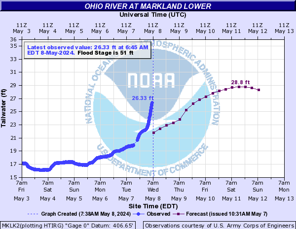
MKLK2:
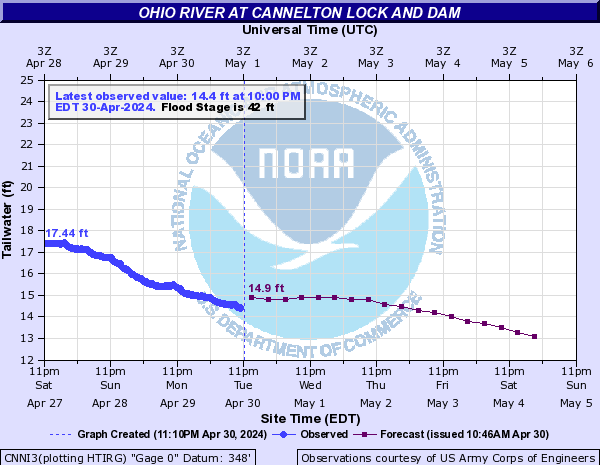
CNNI3:
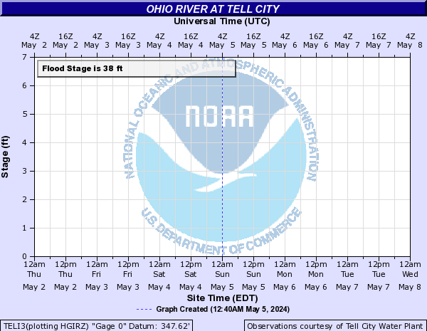
TELI3:
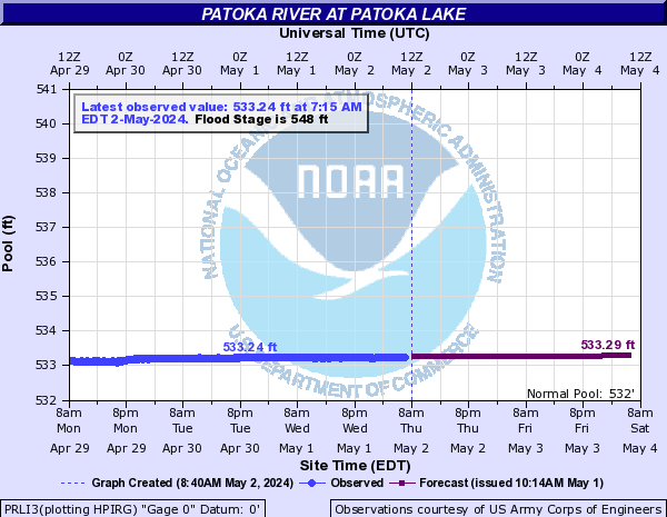
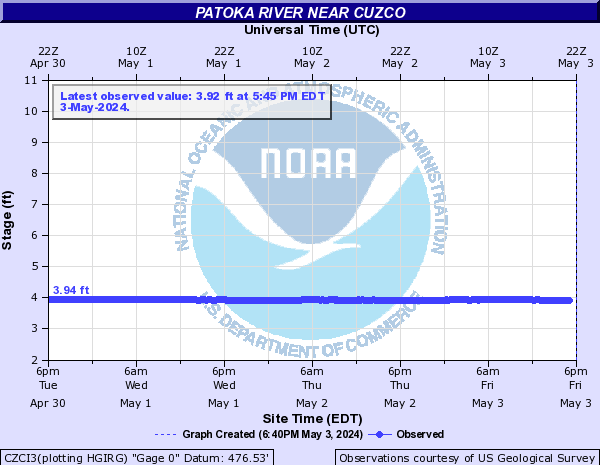
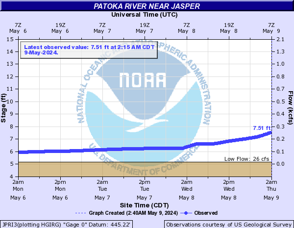
Patoka River (Click on an image to go to hydrograph webpage)
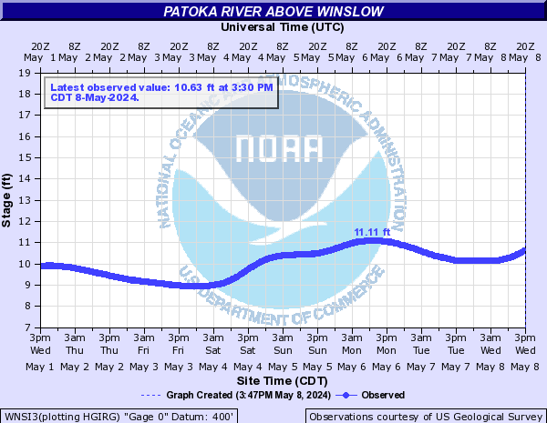
WNSI3:
PRLI3:
CZCI3:
JPRI3:
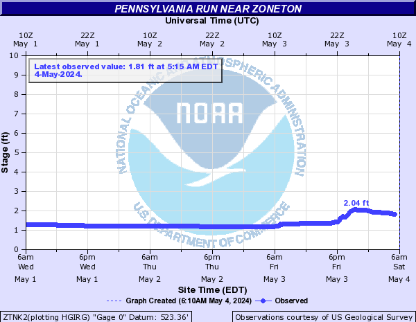
Pennsylvania Run (Click on an image to go to hydrograph webpage)
ZTNK2:
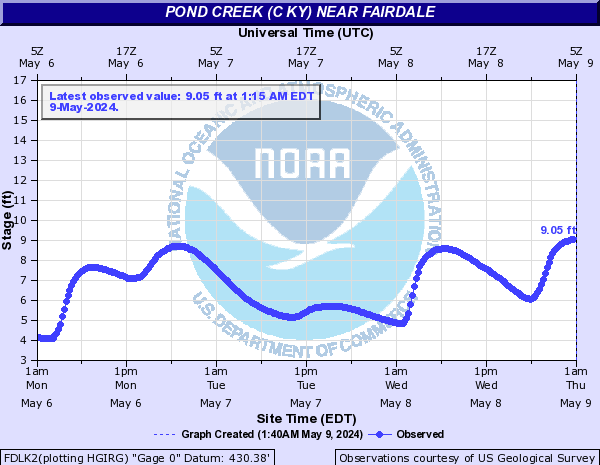
Pond Creek (C KY) (Click on an image to go to hydrograph webpage)
MDOK2:

FDLK2:
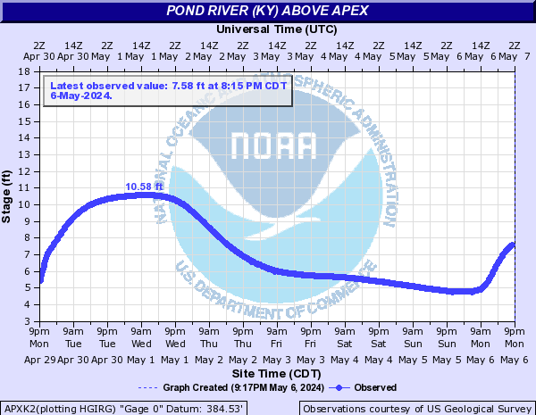
Pond River (KY) (Click on an image to go to hydrograph webpage)
APXK2:
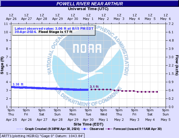
Powell River (Click on an image to go to hydrograph webpage)
ARTT1:
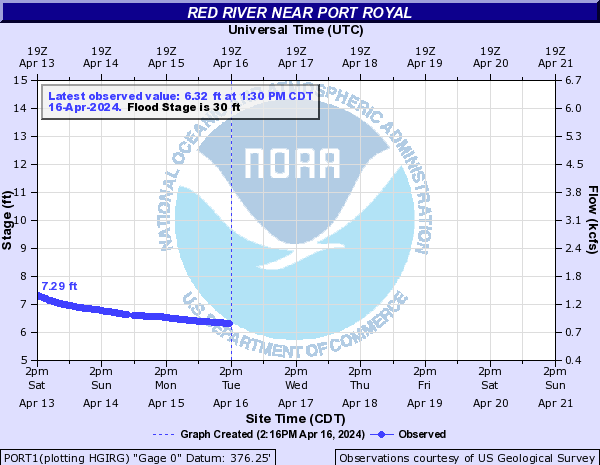
Red River (Click on an image to go to hydrograph webpage)
PORT1:
CYCK2:

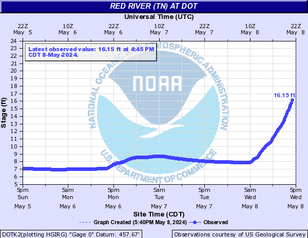
Red River (TN) (Click on an image to go to hydrograph webpage)
DOTK2:
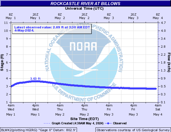
Rockcastle River (Click on an image to go to hydrograph webpage)
BLWK2:
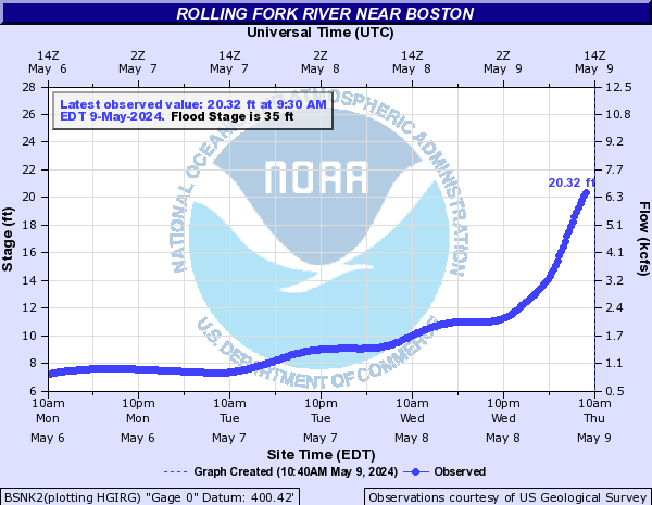
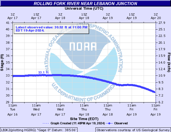
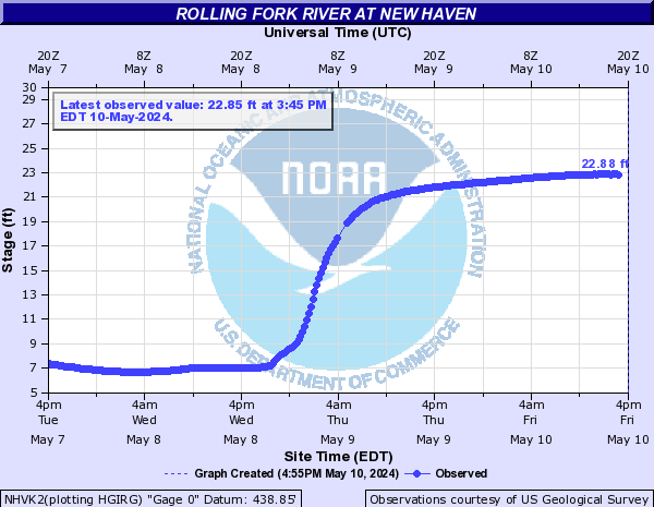
Rolling Fork River (Click on an image to go to hydrograph webpage)
BSNK2:
LBJK2:
NHVK2:
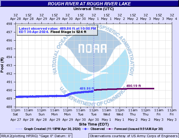
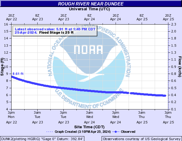
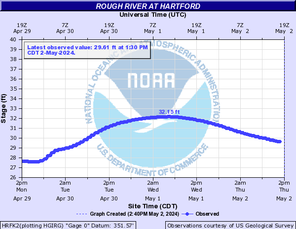
Rough River (Click on an image to go to hydrograph webpage)
RRLK2:
DUNK2:
HRFK2:
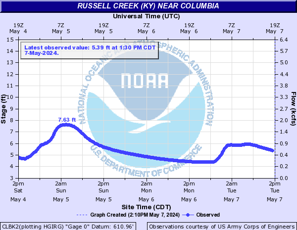
Russell Creek (KY) (Click on an image to go to hydrograph webpage)
CLBK2:
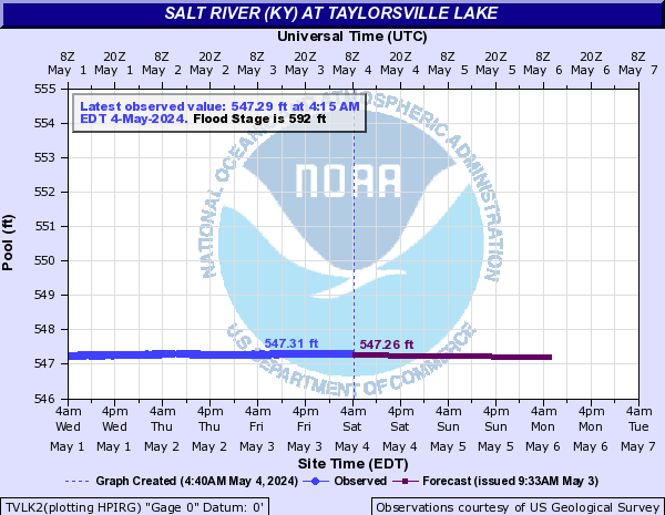
Salt River (KY) (Click on an image to go to hydrograph webpage)
GNBK2:

TVLK2:
SHPK2:

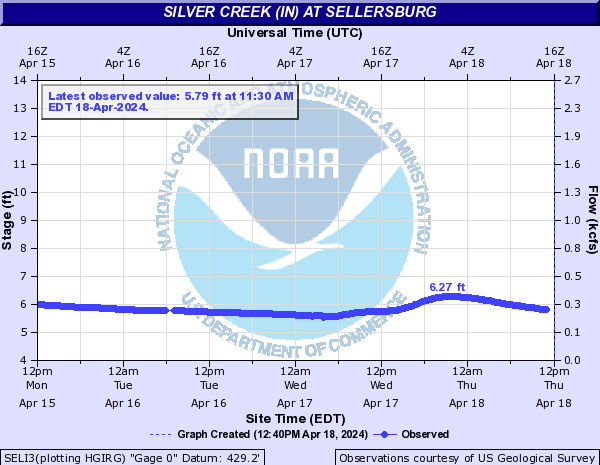
Silver Creek (IN) (Click on an image to go to hydrograph webpage)
SELI3:
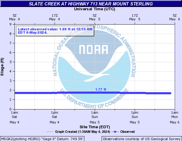
Slate Creek (Click on an image to go to hydrograph webpage)
MSGK2:
Smothers Creek (IN) (Click on an image to go to hydrograph webpage)
SCPI3:

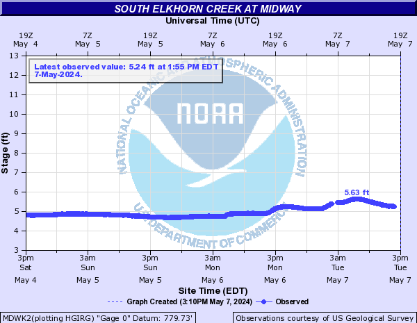
South Elkhorn Creek (Click on an image to go to hydrograph webpage)
MDWK2:
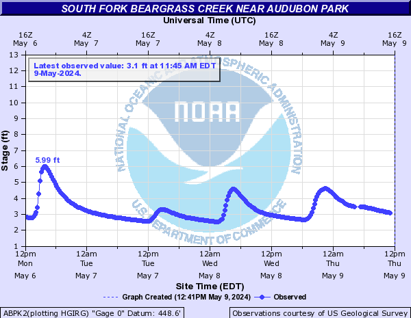
South Fork Beargrass Creek (Click on an image to go to hydrograph webpage)
ABPK2:
LOSK2:
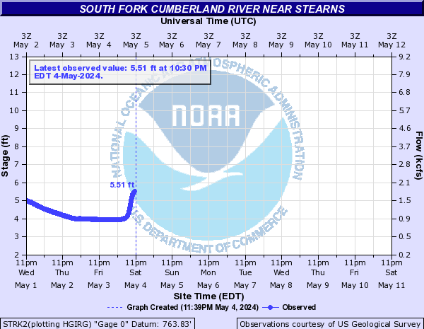
South Fork Cumberland River (Click on an image to go to hydrograph webpage)
STRK2:
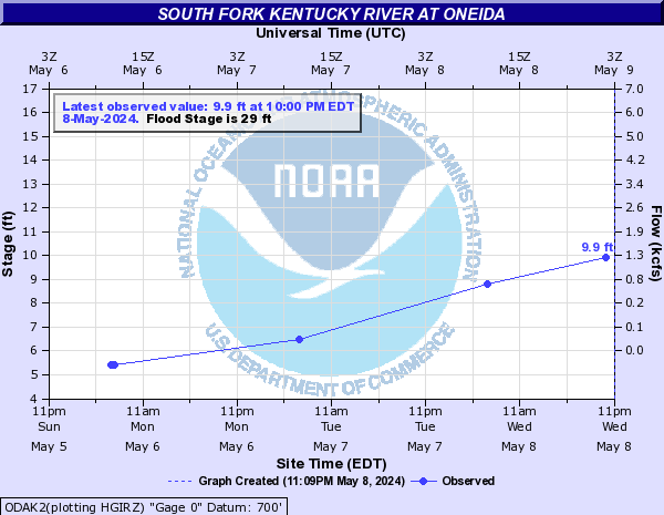
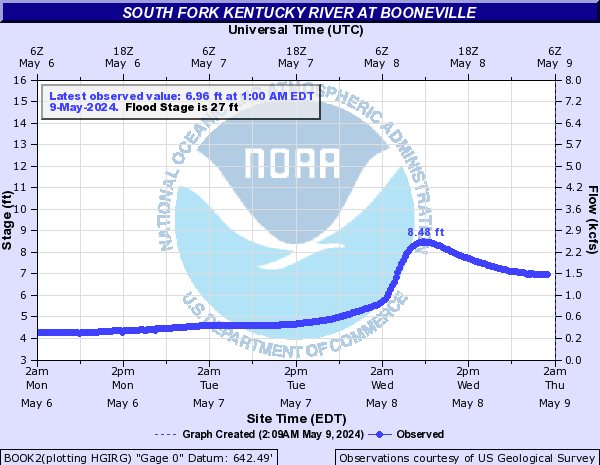
South Fork Kentucky River (Click on an image to go to hydrograph webpage)
ODAK2:
BOOK2:
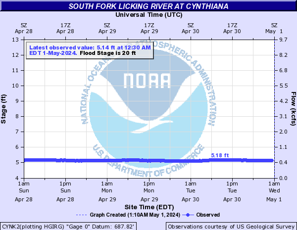
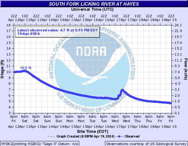
South Fork Licking River (Click on an image to go to hydrograph webpage)
CYNK2:
HYSK2:
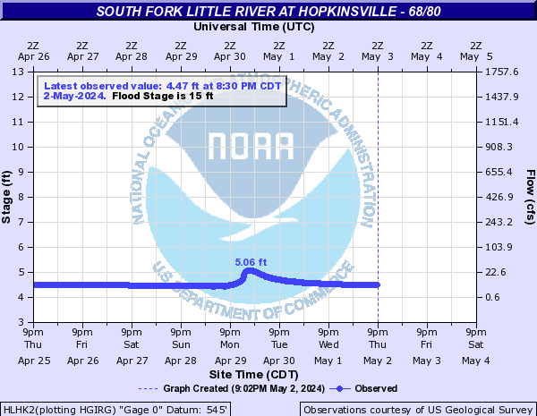
South Fork Little River (Click on an image to go to hydrograph webpage)
HLHK2:
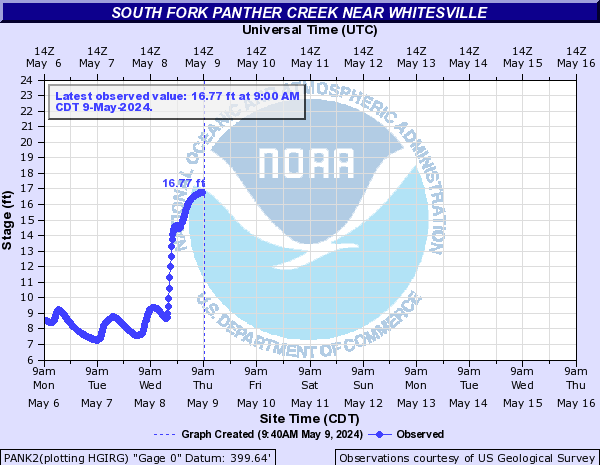
South Fork Panther Creek (Click on an image to go to hydrograph webpage)
PANK2:
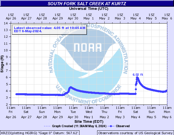
South Fork Salt Creek (Click on an image to go to hydrograph webpage)
KRZI3:
Stoner Creek (Click on an image to go to hydrograph webpage)
PRSK2:

Sturgeon Creek (Click on an image to go to hydrograph webpage)
CRMK2:

Vernon Fork Muscatatuck River (Click on an image to go to hydrograph webpage)
VRNI3:

West Fork Blue River (Click on an image to go to hydrograph webpage)
SEMI3:

West Fork Drakes Creek (Click on an image to go to hydrograph webpage)
FRLK2:

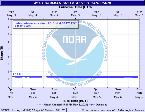
West Hickman Creek (Click on an image to go to hydrograph webpage)
VTPK2:
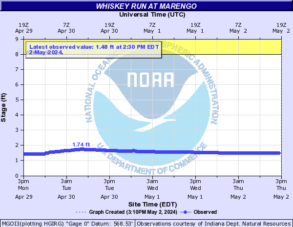
Whiskey Run (Click on an image to go to hydrograph webpage)
MGOI3:
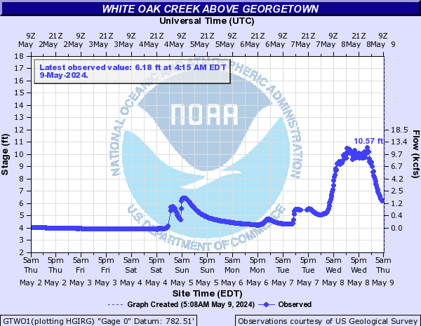
White Oak Creek (Click on an image to go to hydrograph webpage)
GTWO1:
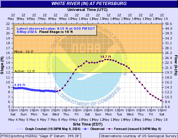
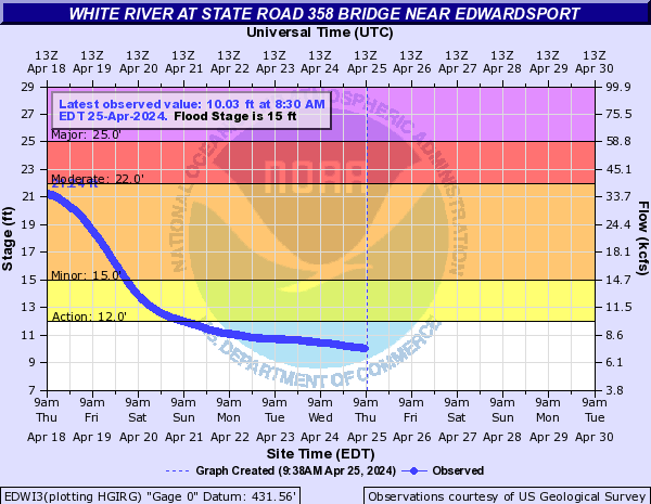
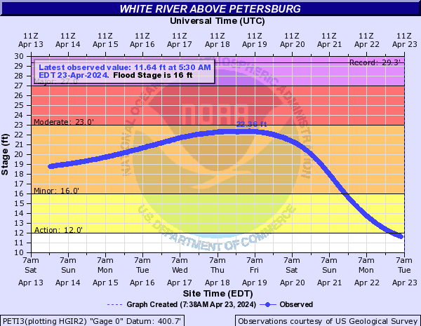
White River (IN) (Click on an image to go to hydrograph webpage)
NWBI3:

FREI3:
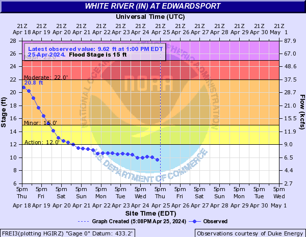
EDWI3:
PETI3:
PTRI3: