Ahoskie Creek (Click on an image to go to hydrograph webpage)
AHSN7:

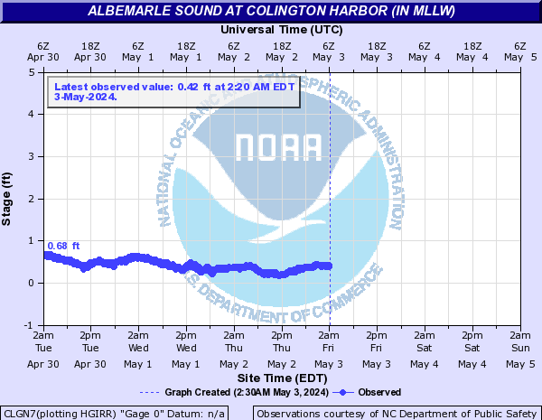
Albemarle Sound (Click on an image to go to hydrograph webpage)
KITN7:

CLGN7:
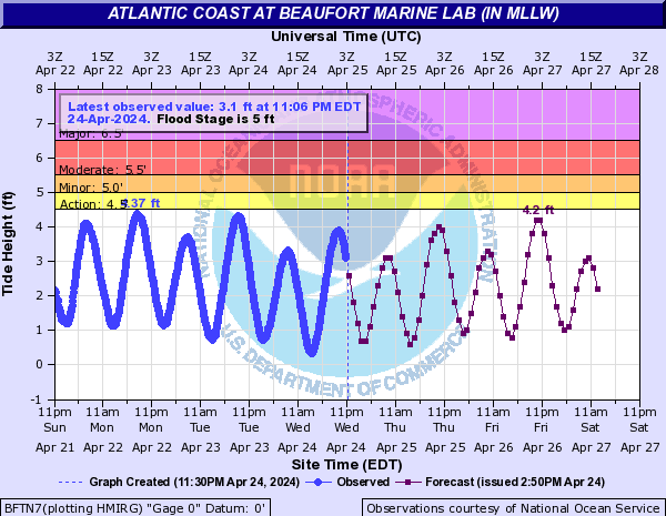
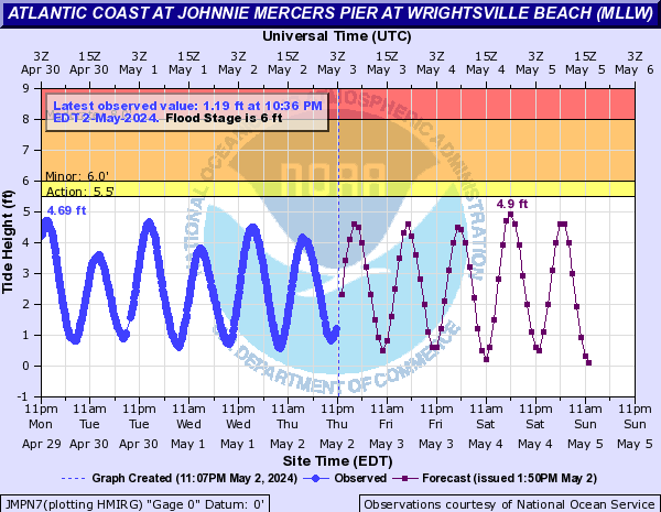
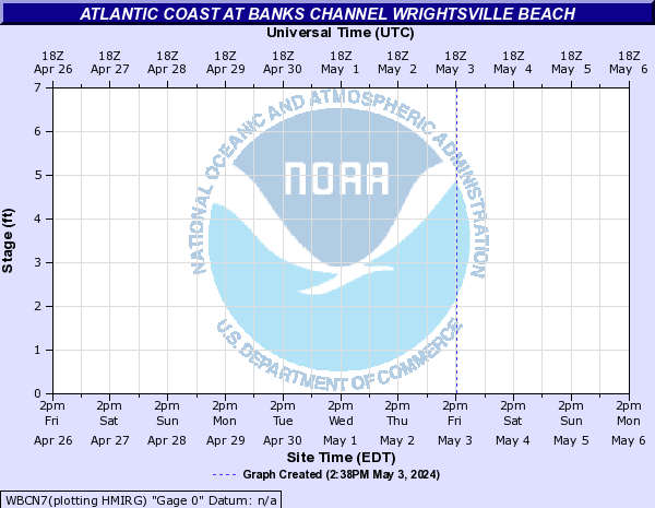
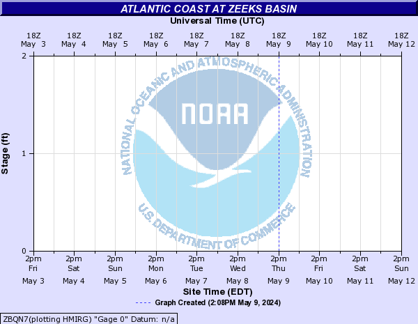
Atlantic Coast (Click on an image to go to hydrograph webpage)
BFTN7:
JMPN7:
DUKN7:

SNSN7:

RDPN7:

CBCN7:

WBCN7:
ZBQN7:
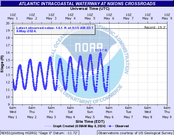
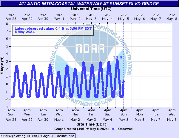
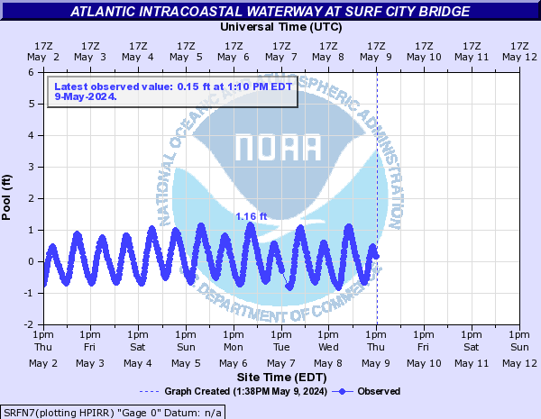
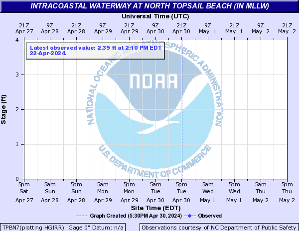
Atlantic Intracoastal Waterway (Click on an image to go to hydrograph webpage)
NIXS1:
SBNN7:
SRFN7:
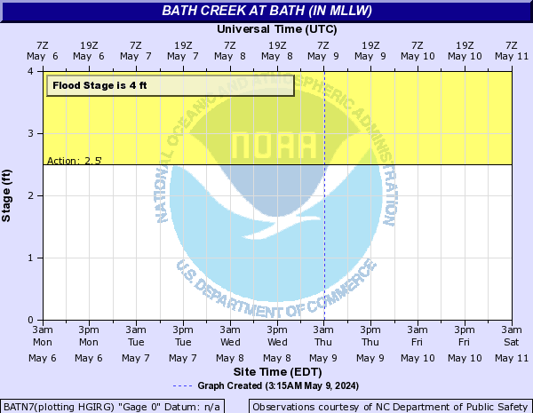
Bath Creek (Click on an image to go to hydrograph webpage)
BATN7:
Bay River (Click on an image to go to hydrograph webpage)
BYBN7:

Beaverdam Creek (NC) (Click on an image to go to hydrograph webpage)
CRDN7:

Big Swamp (Click on an image to go to hydrograph webpage)
BGSN7:

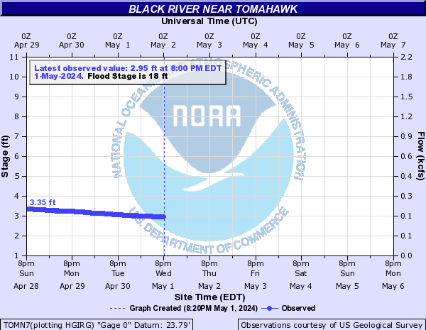
Black River (Click on an image to go to hydrograph webpage)
TOMN7:
BRAN7:

BCUN7:

Blounts Creek (Click on an image to go to hydrograph webpage)
BCFN7:
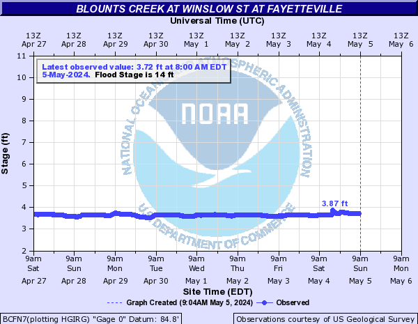
BCFN7:
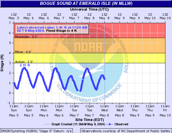
Bogue Sound (Click on an image to go to hydrograph webpage)
EMDN7:
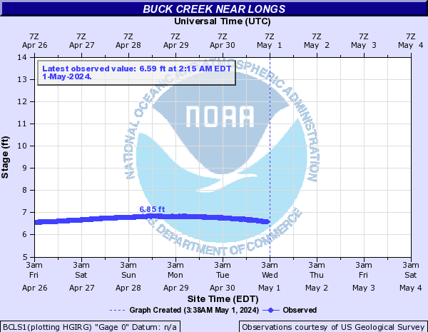
Buck Creek (Click on an image to go to hydrograph webpage)
BCLS1:
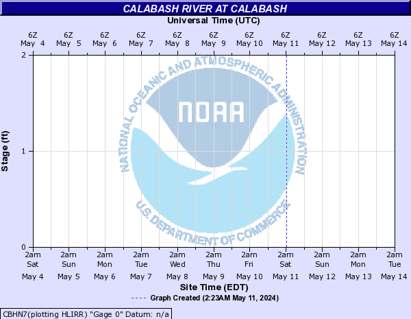
Calabash River (Click on an image to go to hydrograph webpage)
CBHN7:
Cape Creek (Click on an image to go to hydrograph webpage)
FESN7:

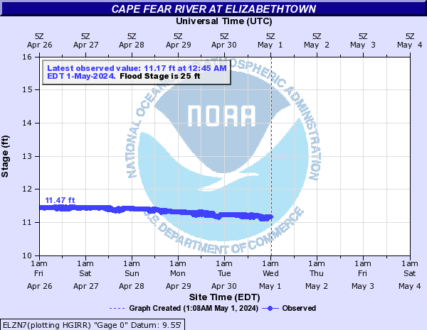
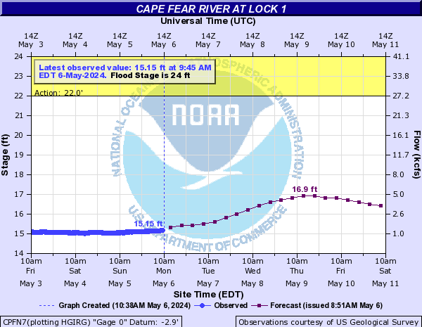
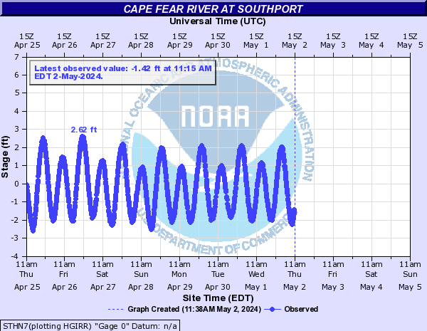
Cape Fear River (Click on an image to go to hydrograph webpage)
LLLN7:

STPN7:

ELZN7:
FAYN7:

CPFN7:
WLON7:

STHN7:
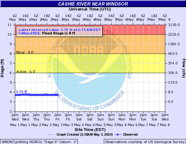
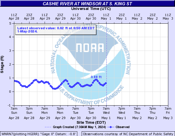
Cashie River (Click on an image to go to hydrograph webpage)
WNDN7:
WNRN7:
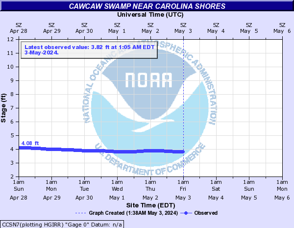
Cawcaw Swamp (Click on an image to go to hydrograph webpage)
CCSN7:
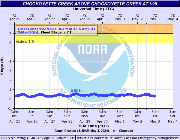
Chockoyette Creek (Click on an image to go to hydrograph webpage)
CHCN7:
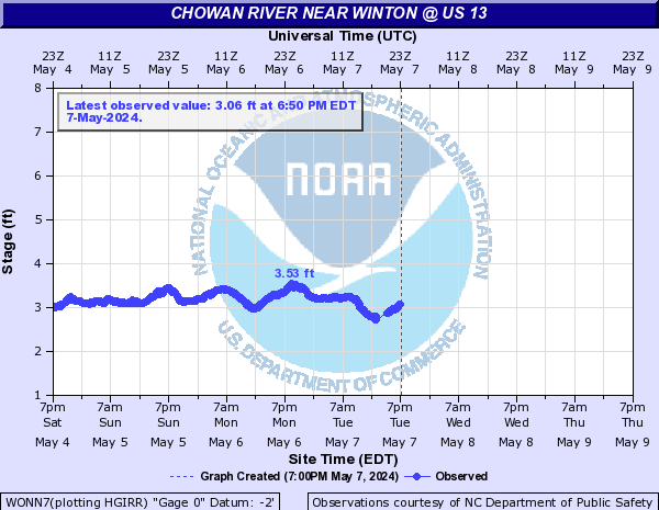
Chowan River (Click on an image to go to hydrograph webpage)
EWPN7:

WONN7:
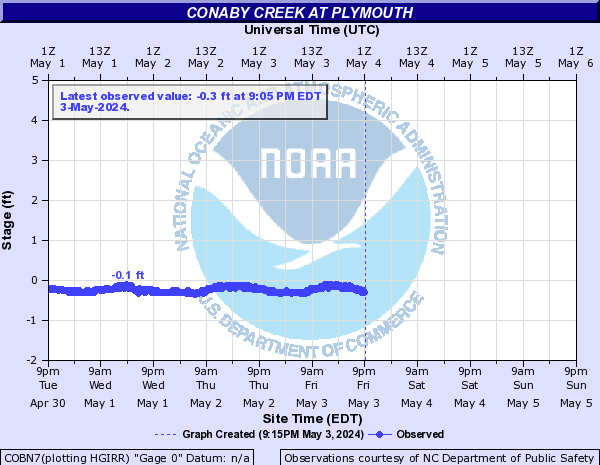
Conaby Creek (Click on an image to go to hydrograph webpage)
COBN7:
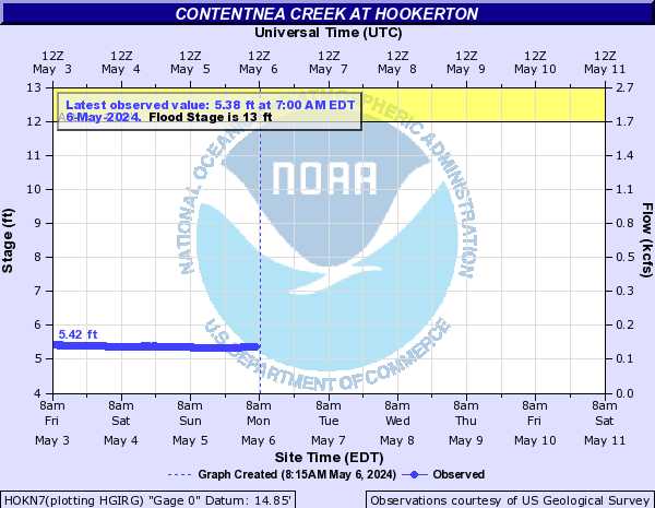
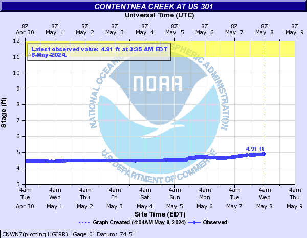
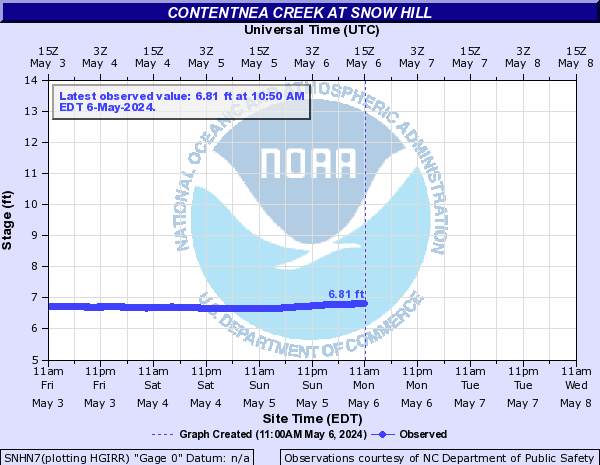
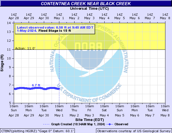
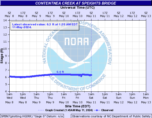
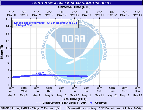
Contentnea Creek (Click on an image to go to hydrograph webpage)
LUCN7:

HOKN7:
CNWN7:
GTNN7:

SNHN7:
CTBN7:
SPBN7:
STNN7:
SHPN7:

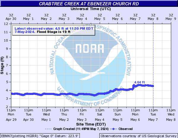
Crabtree Creek (Click on an image to go to hydrograph webpage)
EBNN7:
RLHN7:

ADRN7:

OWFN7:

CRBN7:

MRVN7:

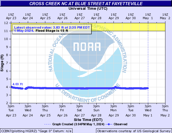
Cross Creek NC (Click on an image to go to hydrograph webpage)
CCHN7:

CCBN7:
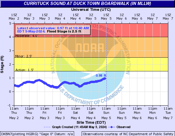
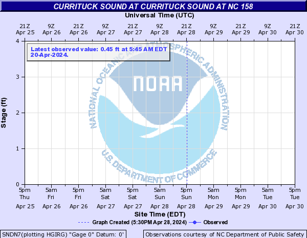
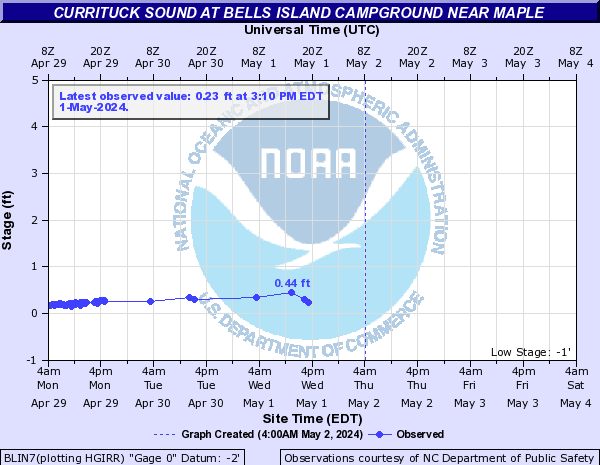
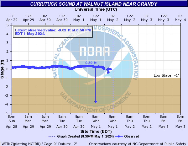
Currituck Sound (Click on an image to go to hydrograph webpage)
DKBN7:
OBCN7:

PTHN7:

SNDN7:
BLIN7:
CBRN7:

WTIN7:
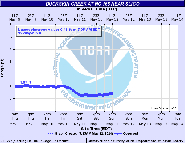
SLGN7:
Deep Creek (NC) (Click on an image to go to hydrograph webpage)
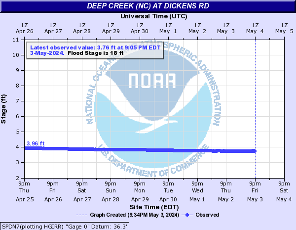
SPDN7:
Ellerbe Creek (NC) (Click on an image to go to hydrograph webpage)
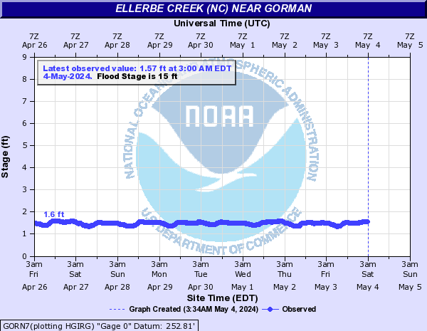
GORN7:
Far Creek (Click on an image to go to hydrograph webpage)
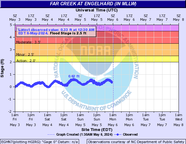
EGHN7:
Fishing Creek (Click on an image to go to hydrograph webpage)
EFDN7:

FCWN7:

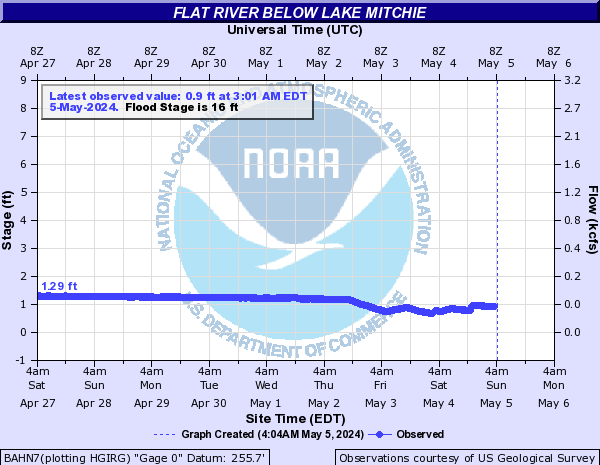
Flat River (Click on an image to go to hydrograph webpage)
BAHN7:
BMAN7:

Great Dismal Swamp Canal (Click on an image to go to hydrograph webpage)
SMLN7:

Green Mill Run (Click on an image to go to hydrograph webpage)
GVLN7:

Grindle Creek (Click on an image to go to hydrograph webpage)
GRIN7:

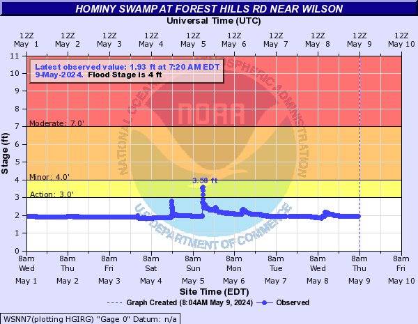
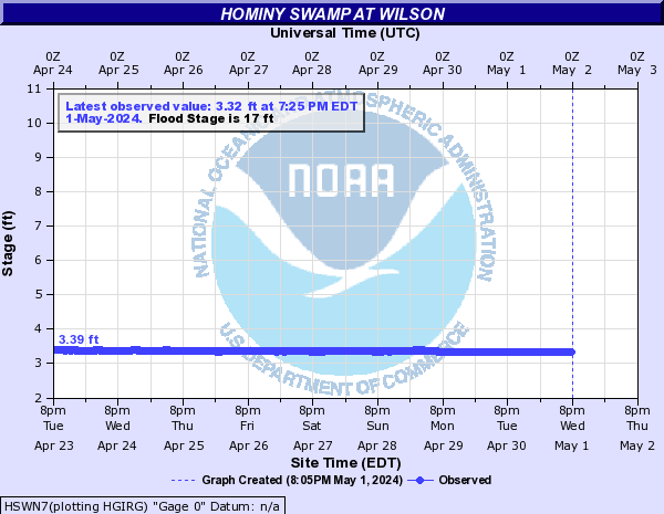
Hominy Swamp (Click on an image to go to hydrograph webpage)
WSNN7:
HSWN7:
Hood Creek (Click on an image to go to hydrograph webpage)
LELN7:

Intracoastal Waterway (Click on an image to go to hydrograph webpage)
TPBN7:
Johnsons Mill Run (Click on an image to go to hydrograph webpage)
JMLN7:

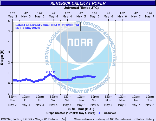
Kendrick Creek (Click on an image to go to hydrograph webpage)
ROPN7:
Kitty Hawk Bay (Click on an image to go to hydrograph webpage)
KLLN7:

Lake Mattamuskeet (Click on an image to go to hydrograph webpage)
MSKN7:

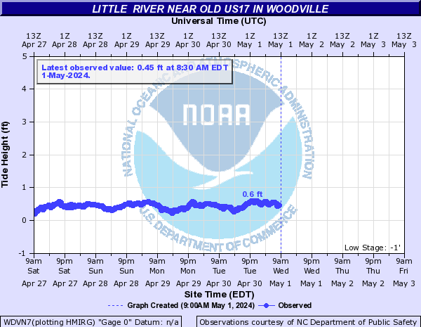
Little River (Click on an image to go to hydrograph webpage)
WDVN7:
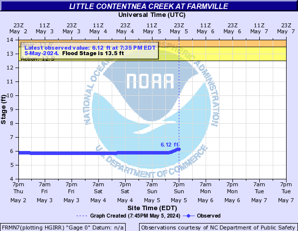
Little Contentnea Creek (Click on an image to go to hydrograph webpage)
FRMN7:
AYDN7:

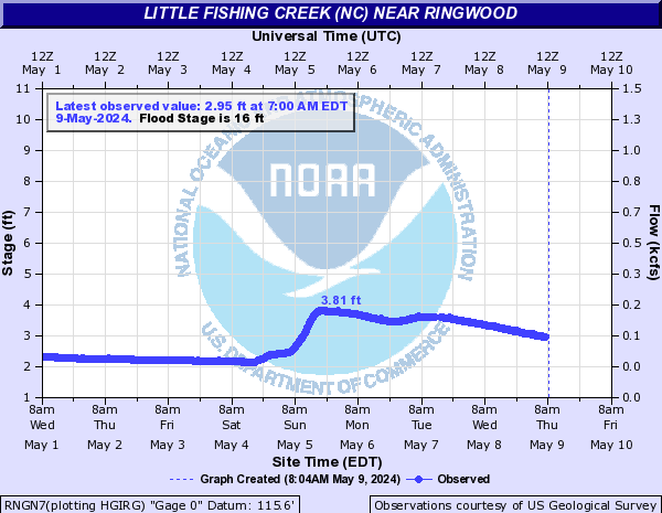
Little Fishing Creek (NC) (Click on an image to go to hydrograph webpage)
RNGN7:
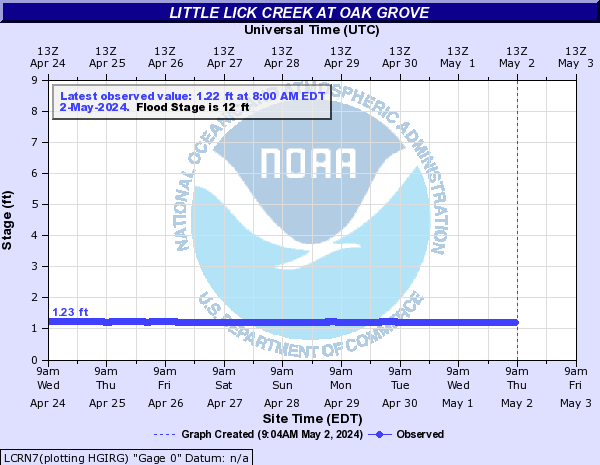
Little Lick Creek (Click on an image to go to hydrograph webpage)
LCRN7:
Little River (Click on an image to go to hydrograph webpage)
FTHN7:

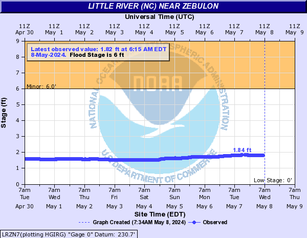
Little River (NC) (Click on an image to go to hydrograph webpage)
LRZN7:
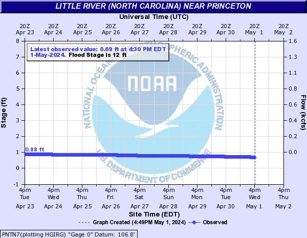
Little River (North Carolina) (Click on an image to go to hydrograph webpage)
PNTN7:
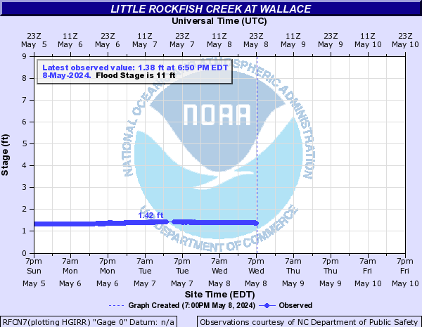
Little Rockfish Creek (Click on an image to go to hydrograph webpage)
RFCN7:
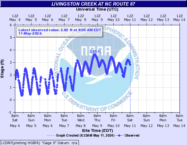
Livingston Creek (Click on an image to go to hydrograph webpage)
LCDN7:
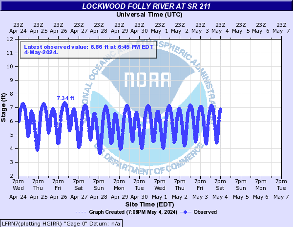
Lockwood Folly River (Click on an image to go to hydrograph webpage)
LFRN7:
Marsh Creek (NC) (Click on an image to go to hydrograph webpage)
MSHN7:

Meadow Branch (Click on an image to go to hydrograph webpage)
STKN7:
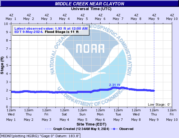
Middle Creek (Click on an image to go to hydrograph webpage)
MIDN7:
Mill Swamp (Click on an image to go to hydrograph webpage)
RCLN7:

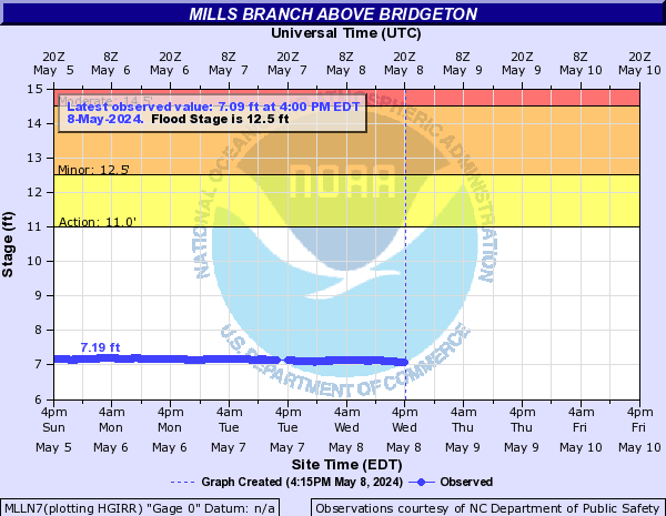
Mills Branch (Click on an image to go to hydrograph webpage)
MLLN7:
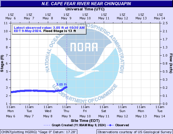
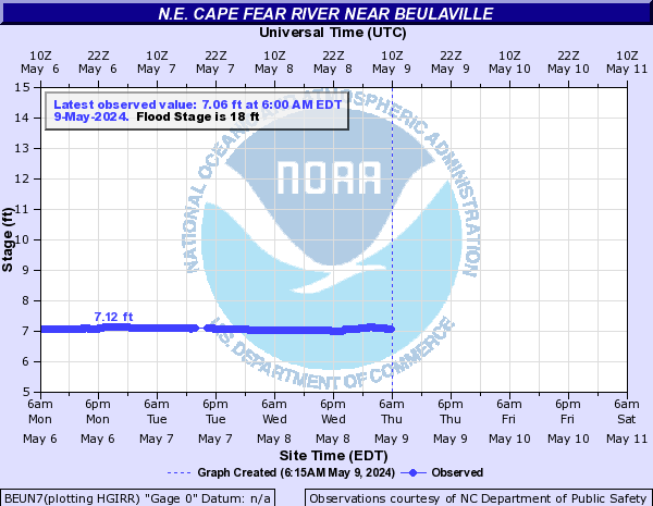
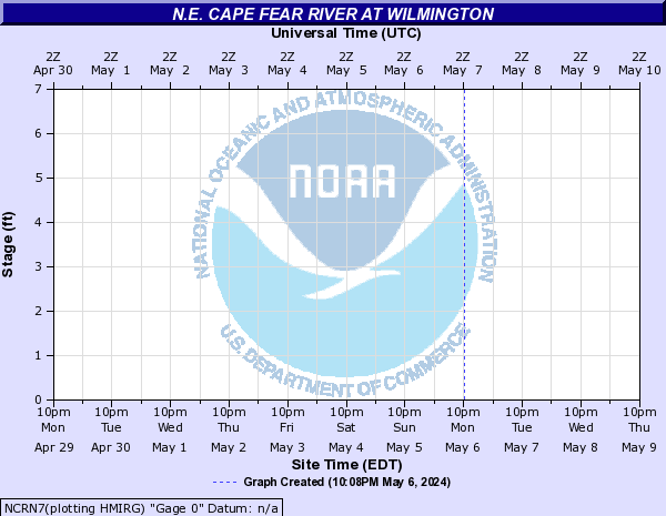
N.E. Cape Fear River (Click on an image to go to hydrograph webpage)
CHIN7:
BGWN7:

BEUN7:
NCRN7:
Nahunta Swamp (Click on an image to go to hydrograph webpage)
NAHN7:

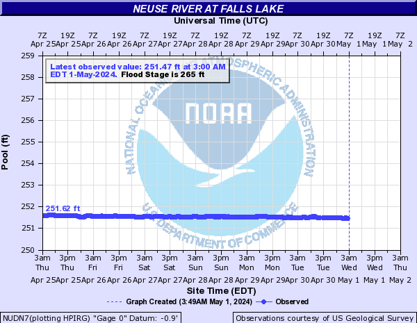
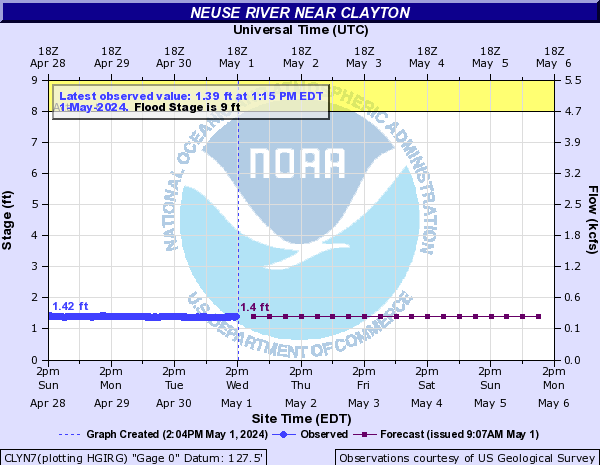
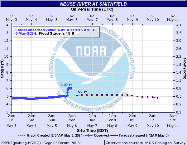
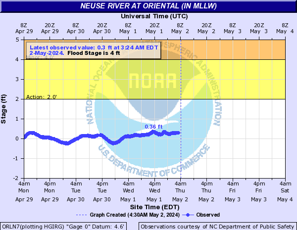
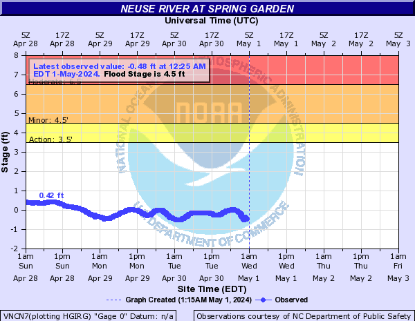
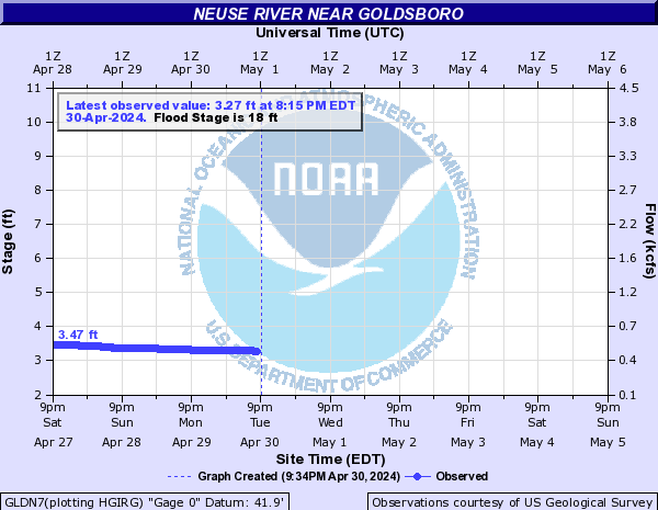
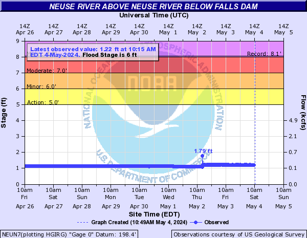
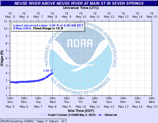
Neuse River (Click on an image to go to hydrograph webpage)
KINN7:

NUDN7:
FTBN7:

CLYN7:
SMFN7:
ORLN7:
VNCN7:
GLDN7:
NEUN7:
NSSN7:
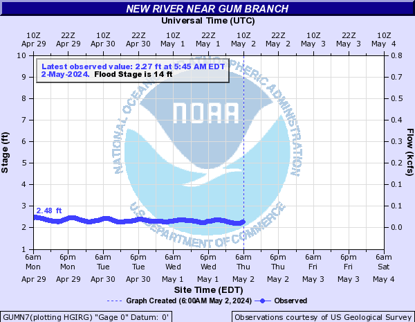
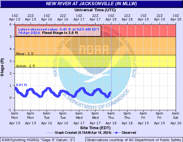
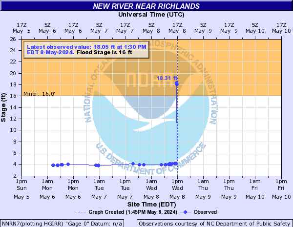
New River (Click on an image to go to hydrograph webpage)
GUMN7:
JCKN7:
NNRN7:
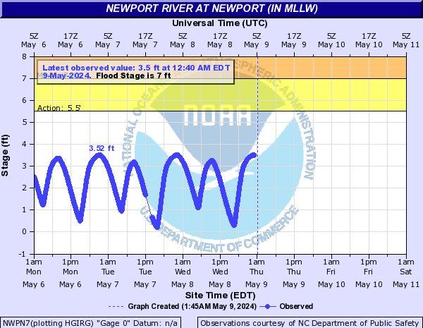
Newport River (Click on an image to go to hydrograph webpage)
NWPN7:
North Fork Alligator River (Click on an image to go to hydrograph webpage)
ALIN7:

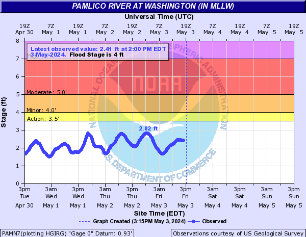
Pamlico River (Click on an image to go to hydrograph webpage)
PAMN7:
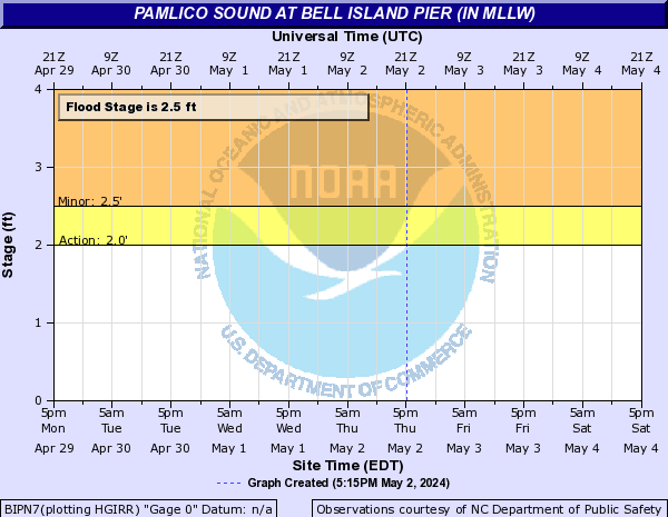
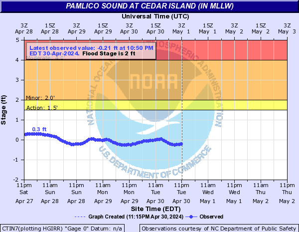
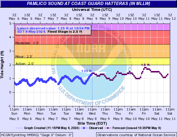
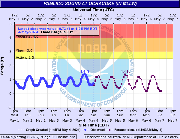
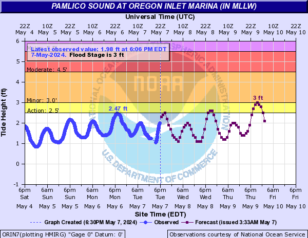
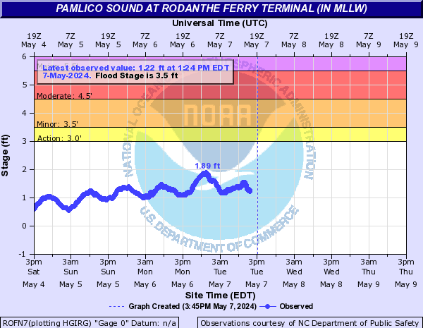
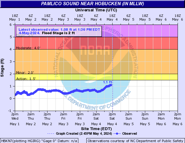
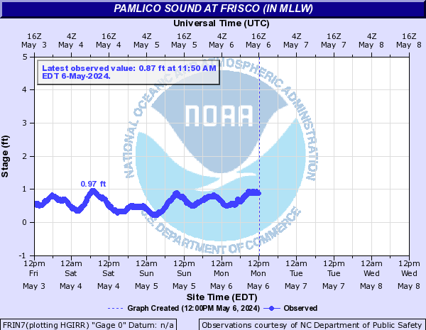
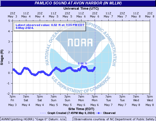
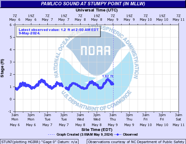
Pamlico Sound (Click on an image to go to hydrograph webpage)
BIPN7:
AVON7:

CTIN7:
HCGN7:
OCAN7:
ORIN7:
ROFN7:
HBKN7:
FRIN7:
AVNN7:
STUN7:
Parker Creek (Click on an image to go to hydrograph webpage)
PKCN7:

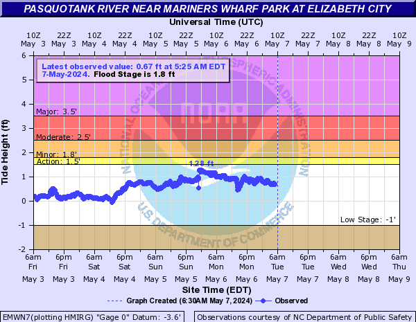
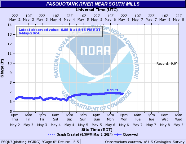
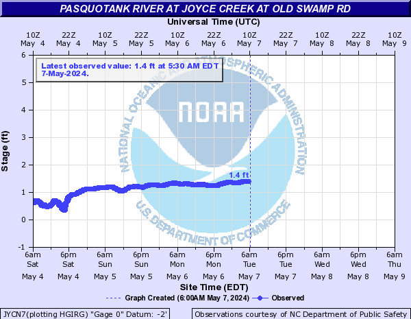
Pasquotank River (Click on an image to go to hydrograph webpage)
EMWN7:
PSQN7:
JYCN7:
Perquimans River (Click on an image to go to hydrograph webpage)
HTFN7:

HFDN7:

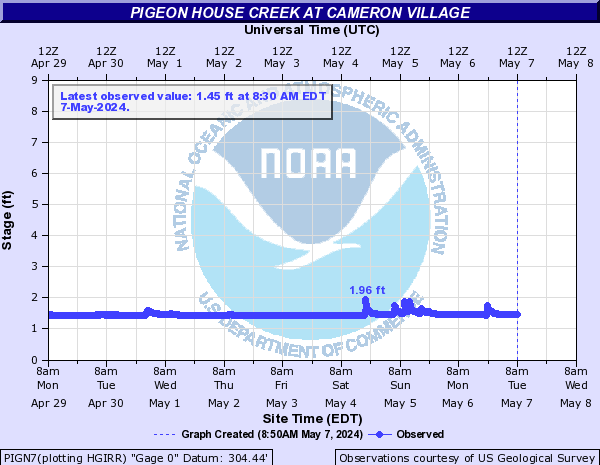
Pigeon House Creek (Click on an image to go to hydrograph webpage)
PIGN7:
PHFN7:

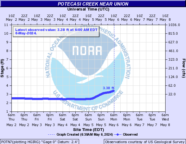
Potecasi Creek (Click on an image to go to hydrograph webpage)
POTN7:
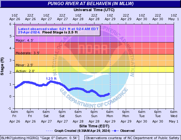
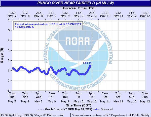
Pungo River (Click on an image to go to hydrograph webpage)
BLHN7:
PNGN7:
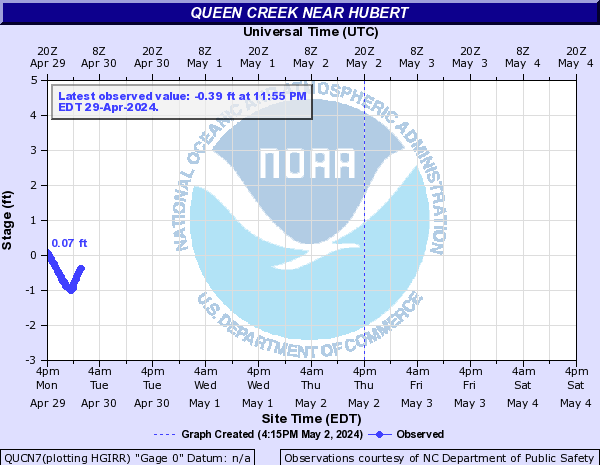
Queen Creek (Click on an image to go to hydrograph webpage)
QUCN7:
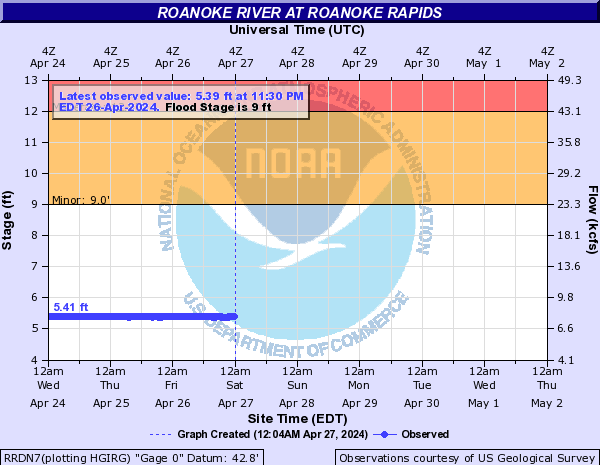
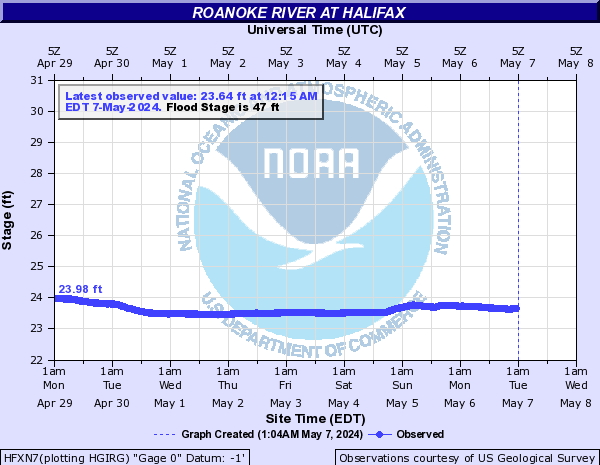
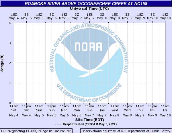
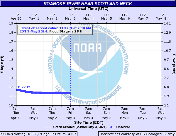
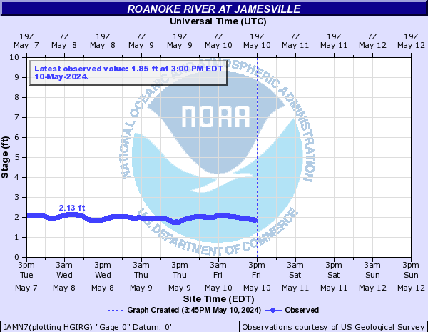
Roanoke River (Click on an image to go to hydrograph webpage)
HMLN7:

RRDN7:
HFXN7:
WLLN7:

OCCN7:
SCON7:
JAMN7:
WESN7:

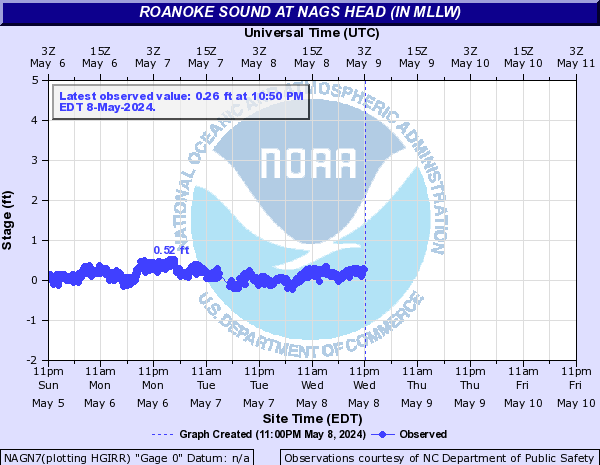
Roanoke Sound (Click on an image to go to hydrograph webpage)
NAGN7:
POIN7:

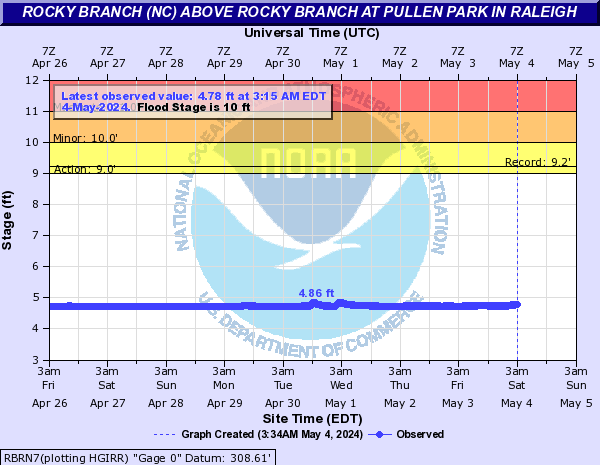
Rocky Branch (NC) (Click on an image to go to hydrograph webpage)
RBRN7:
Scuppernong River (Click on an image to go to hydrograph webpage)
COLN7:
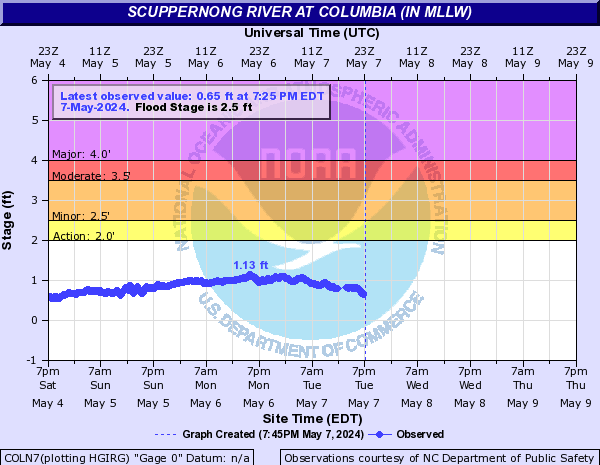
SCPN7:

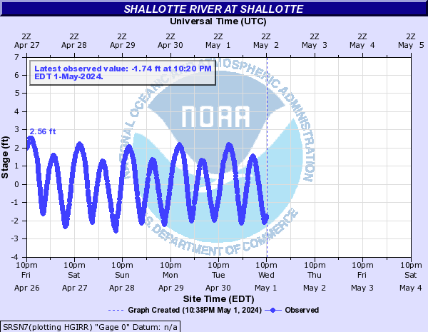
Shallotte River (Click on an image to go to hydrograph webpage)
SRSN7:
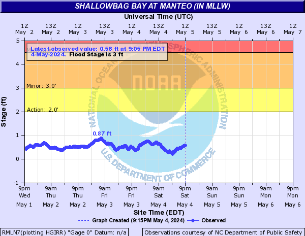
Shallowbag Bay (Click on an image to go to hydrograph webpage)
RMLN7:
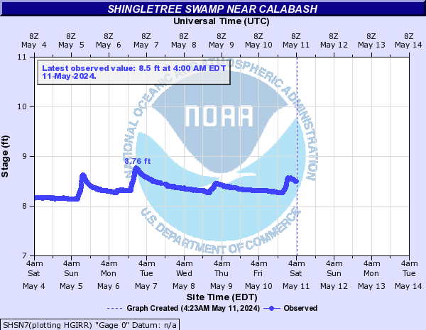
Shingletree Swamp (Click on an image to go to hydrograph webpage)
SHSN7:
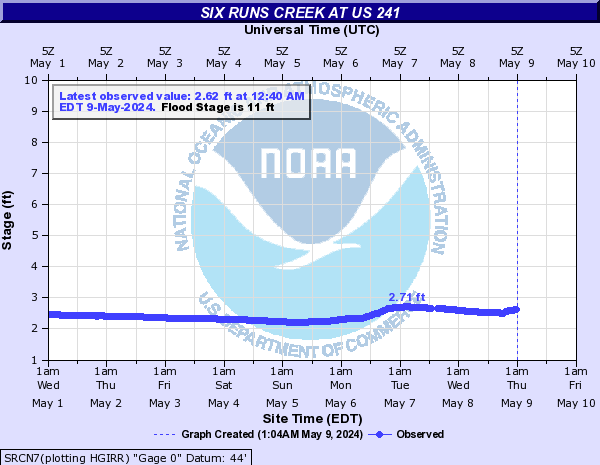
Six Runs Creek (Click on an image to go to hydrograph webpage)
SRCN7:
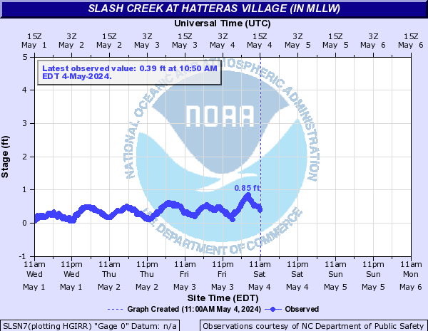
Slash Creek (Click on an image to go to hydrograph webpage)
SLSN7:
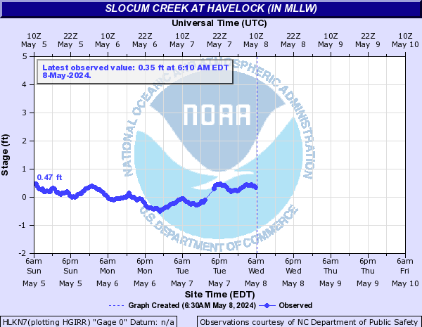
Slocum Creek (Click on an image to go to hydrograph webpage)
HLKN7:
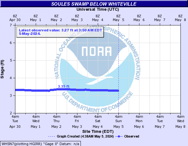
Soules Swamp (Click on an image to go to hydrograph webpage)
WHSN7:
South Creek (Click on an image to go to hydrograph webpage)
ARON7:

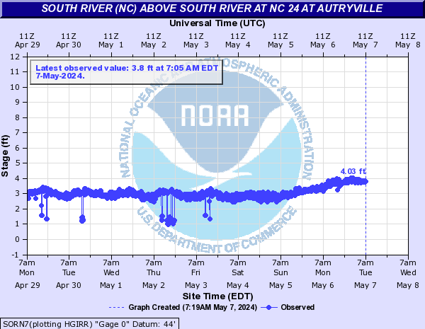
South River (NC) (Click on an image to go to hydrograph webpage)
SORN7:
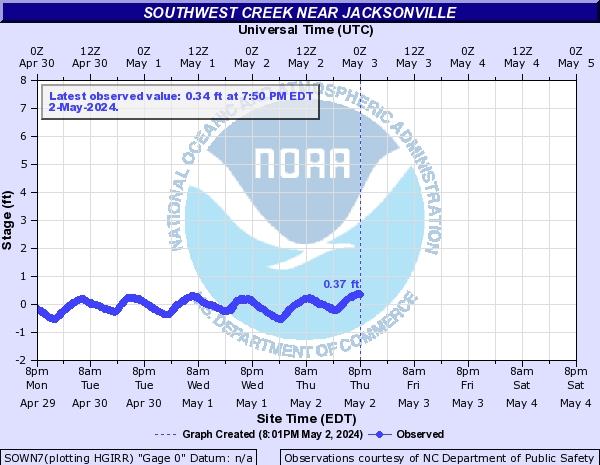
Southwest Creek (Click on an image to go to hydrograph webpage)
SOWN7:
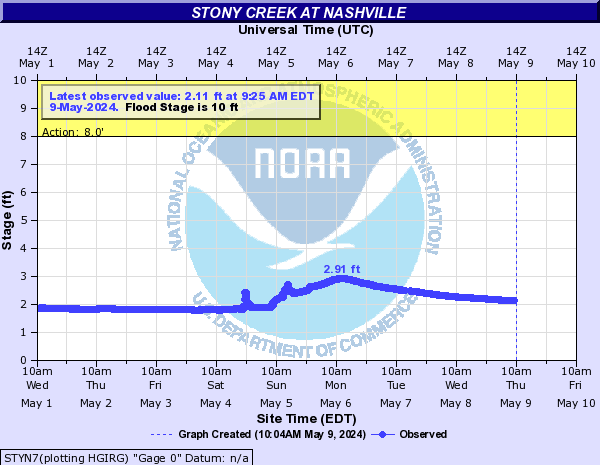
Stony Creek (Click on an image to go to hydrograph webpage)
STON7:

STYN7:
SCGN7:

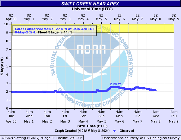
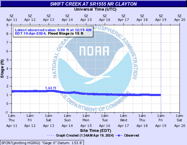
Swift Creek (Click on an image to go to hydrograph webpage)
SWFN7:

APSN7:
VAAN7:

SFCN7:
SFTN7:

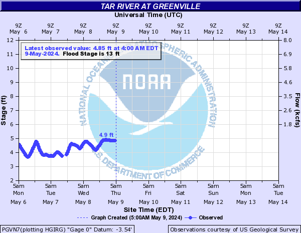
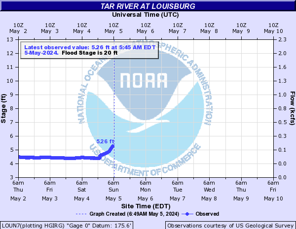
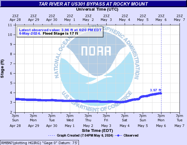
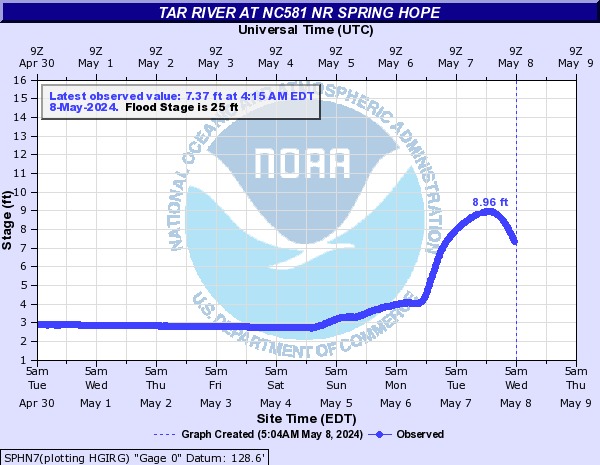
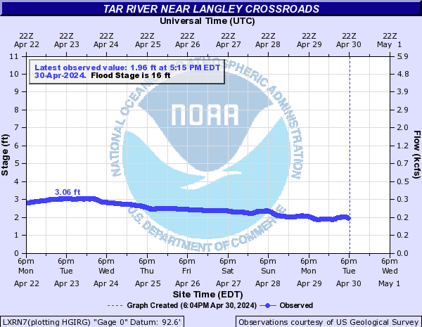
Tar River (Click on an image to go to hydrograph webpage)
TRVN7:

PGVN7:
LOUN7:
GBYN7:
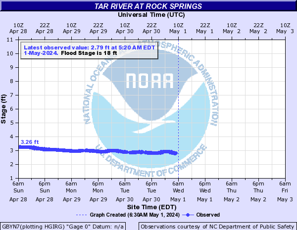
ROKN7:
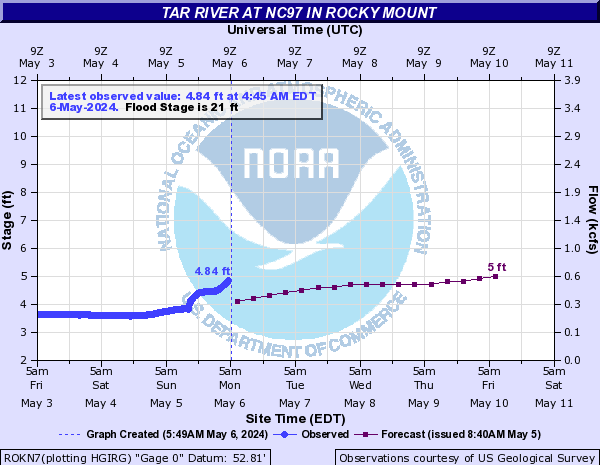
GRMN7:

TARN7:

RMBN7:
SPHN7:
LXRN7:
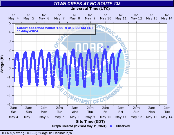
Town Creek (Click on an image to go to hydrograph webpage)
TCLN7:
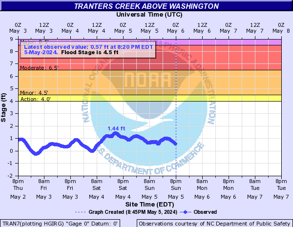
Tranters Creek (Click on an image to go to hydrograph webpage)
TRAN7:
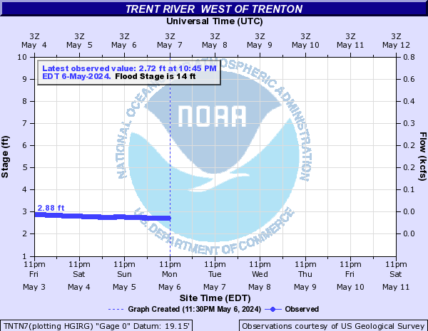
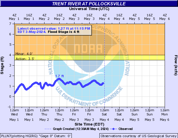
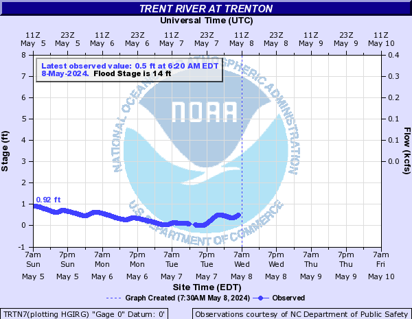
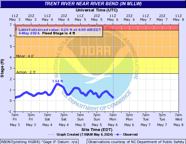
Trent River (Click on an image to go to hydrograph webpage)
TNTN7:
PLLN7:
TRTN7:
BERN7:

RBDN7:
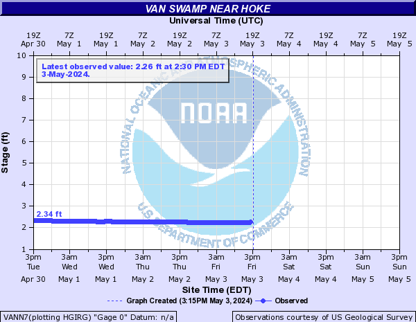
Van Swamp (Click on an image to go to hydrograph webpage)
VANN7:
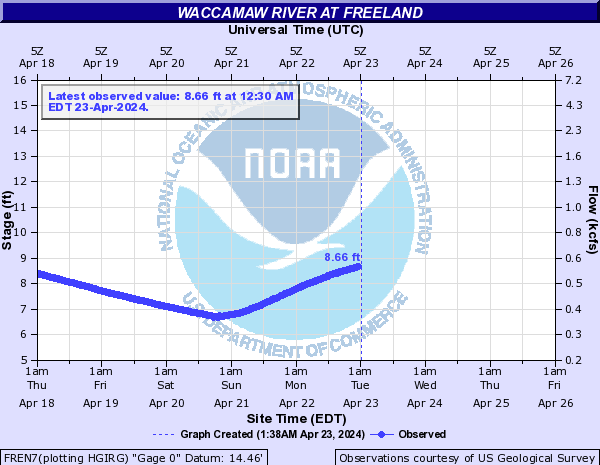
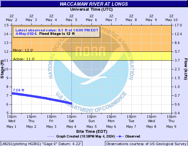
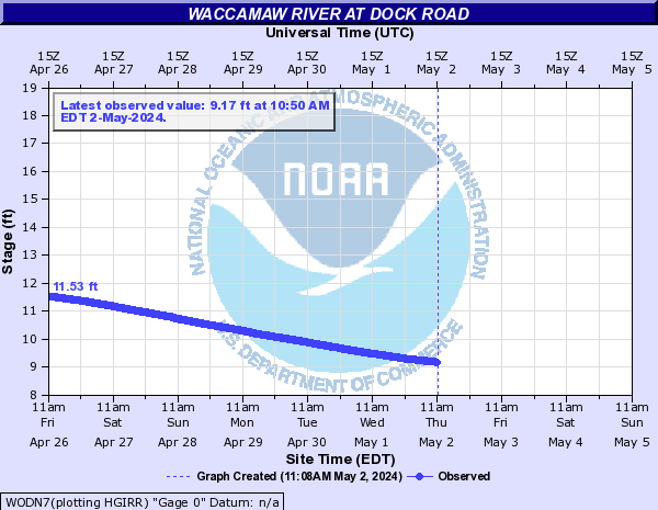
Waccamaw River (Click on an image to go to hydrograph webpage)
FREN7:
LNGS1:
WODN7:
WRBS1:

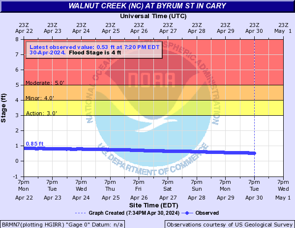
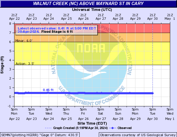
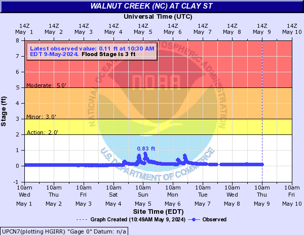
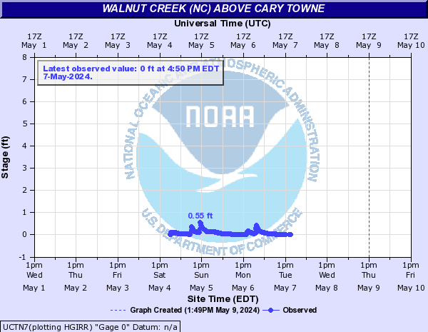
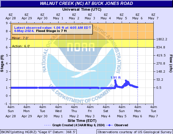
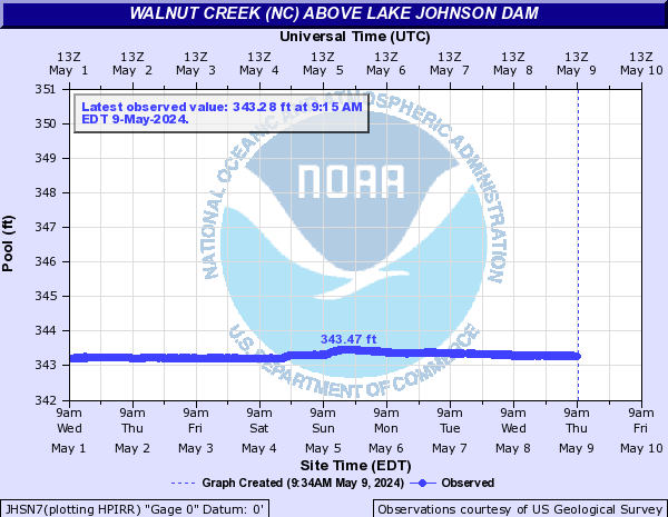
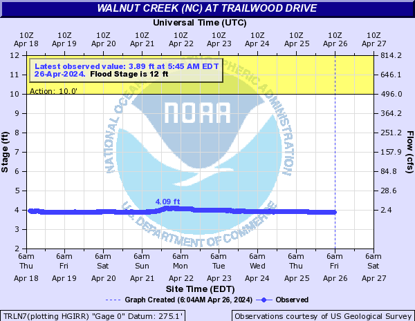
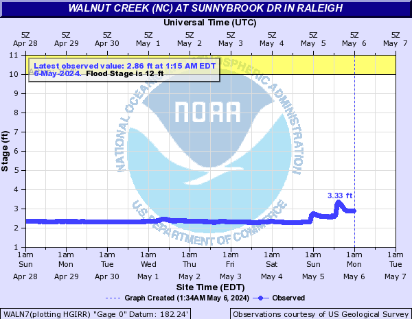
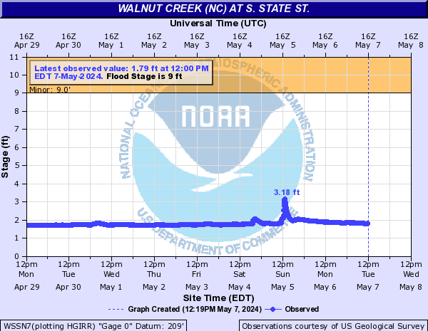
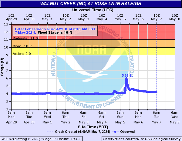
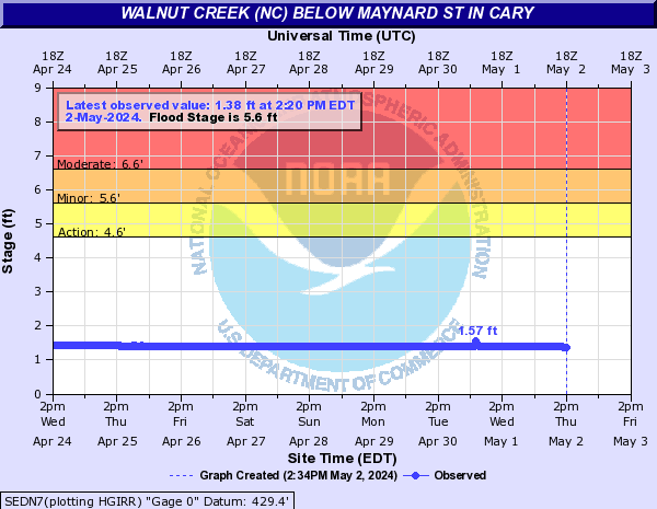
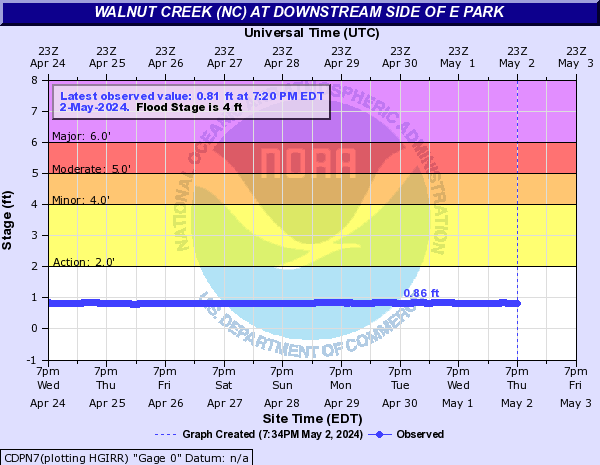
Walnut Creek (NC) (Click on an image to go to hydrograph webpage)
BRMN7:
SEMN7:
CPEN7:
UPCN7:
UCTN7:
BKJN7:
JHSN7:
TRLN7:
WALN7:
WAWN7:
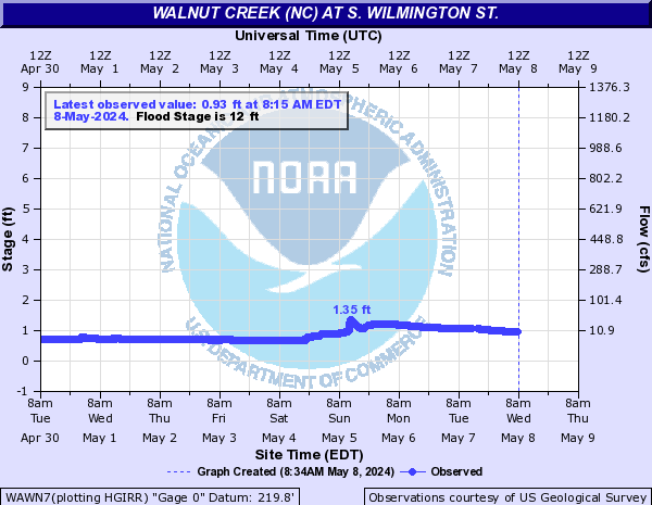
WSSN7:
WRLN7:
SEDN7:
CDPN7:
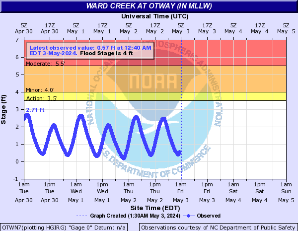
Ward Creek (Click on an image to go to hydrograph webpage)
OTWN7:
White Marsh (Click on an image to go to hydrograph webpage)
WMWN7:

White Oak River (Click on an image to go to hydrograph webpage)
SWBN7:

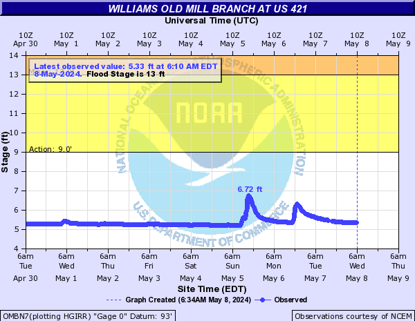
Williams Old Mill Branch (Click on an image to go to hydrograph webpage)
OMBN7: