Arkansas River (Click on an image to go to hydrograph webpage)
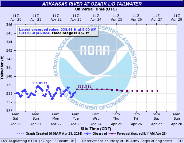
OZGA4:
DARA4:

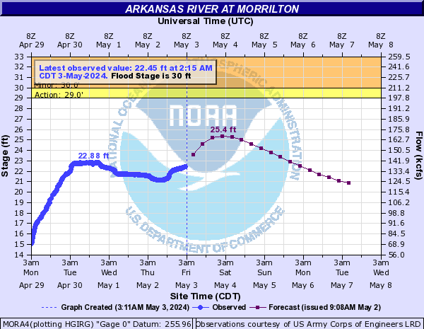
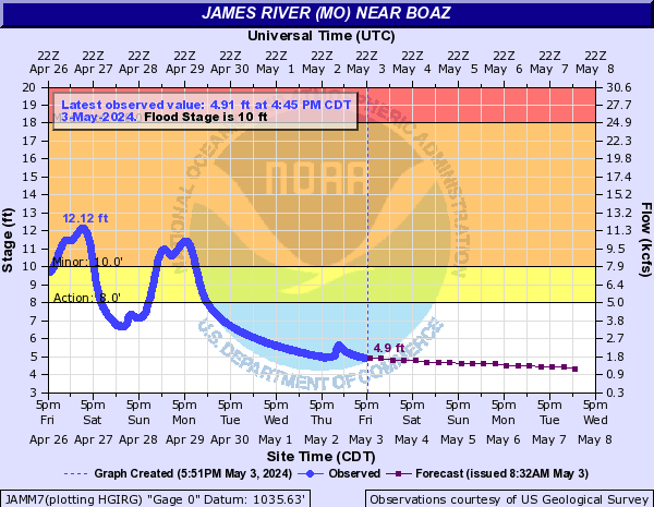
MORA4:
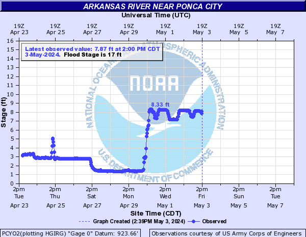
PCYO2:
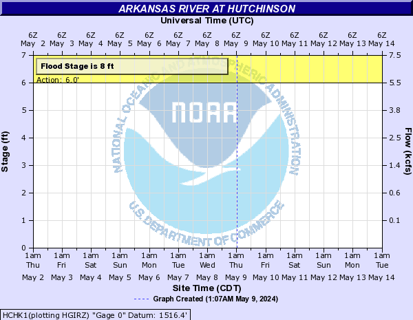
HCHK1:
RLSO2:

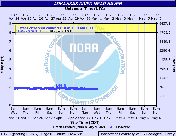
HAVK1:
TODA4:

TLSO2:

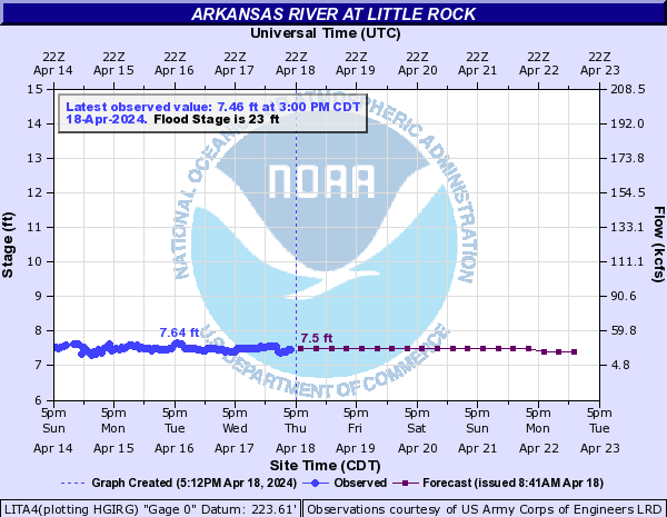
LITA4:
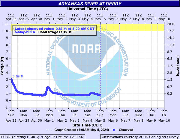
DRBK1:
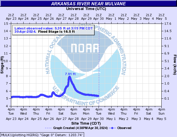
MULK1:
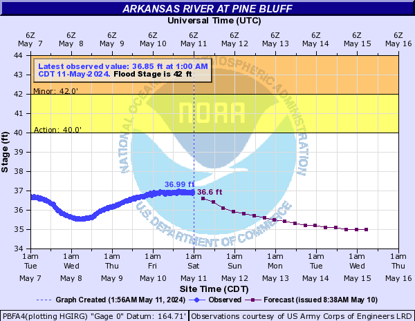
PBFA4:
HSKO2:

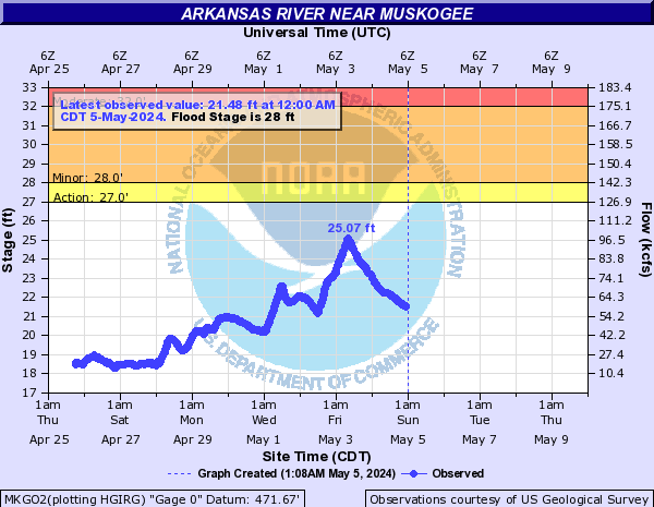
MKGO2:
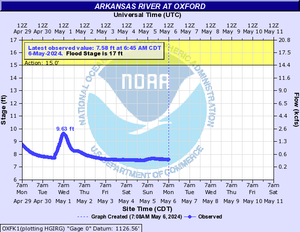
OXFK1:
ARCK1:

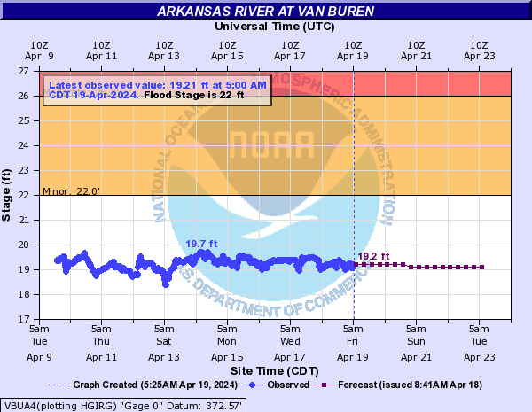
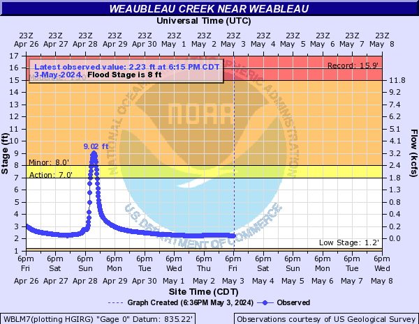
VBUA4:
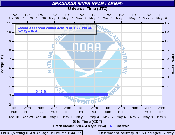
LRDK1:
Baron Fork (Click on an image to go to hydrograph webpage)
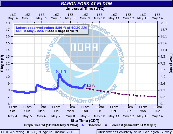
ELDO2:
Bayou Bartholomew (Click on an image to go to hydrograph webpage)
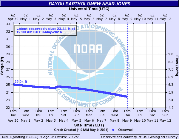
JONL1:
Bayou Dorcheat (Click on an image to go to hydrograph webpage)
SPHL1:

Bear Creek (TX) (Click on an image to go to hydrograph webpage)
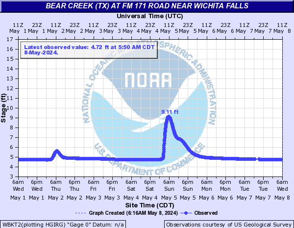
WBKT2:
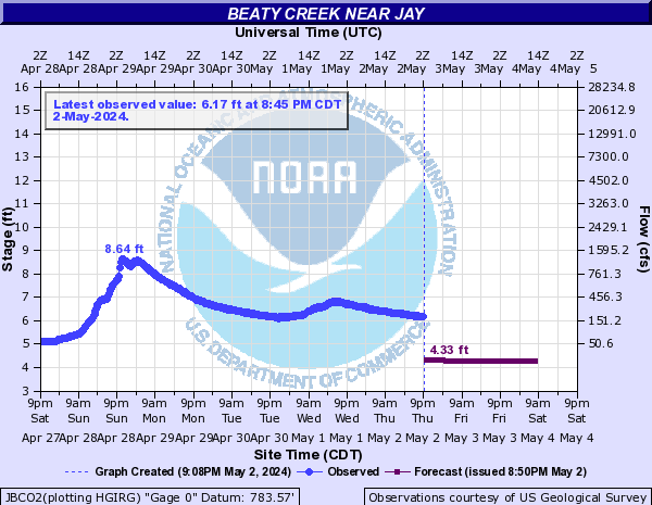
Beaty Creek (Click on an image to go to hydrograph webpage)
JBCO2:
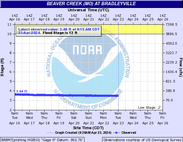
Beaver Creek (MO) (Click on an image to go to hydrograph webpage)
BRBM7:
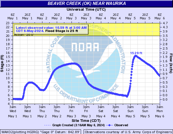
Beaver Creek (OK) (Click on an image to go to hydrograph webpage)
HUBO2:

WRLO2:
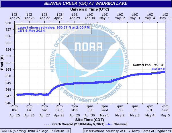
WAKO2:
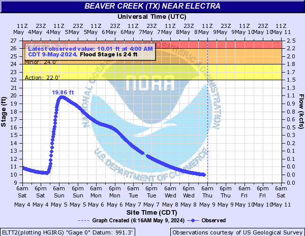
Beaver Creek (TX) (Click on an image to go to hydrograph webpage)
ELTT2:
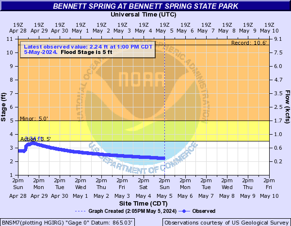
Bennett Spring (Click on an image to go to hydrograph webpage)
BNSM7:
Big Cypress Creek (Click on an image to go to hydrograph webpage)
PBGT2:

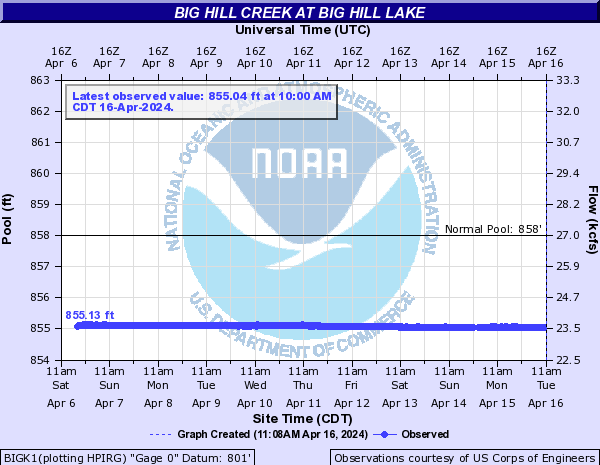
Big Hill Creek (Click on an image to go to hydrograph webpage)
BIGK1:
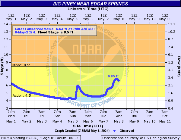
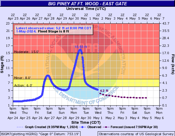
Big Piney (Click on an image to go to hydrograph webpage)
PINM7:
BIGM7:
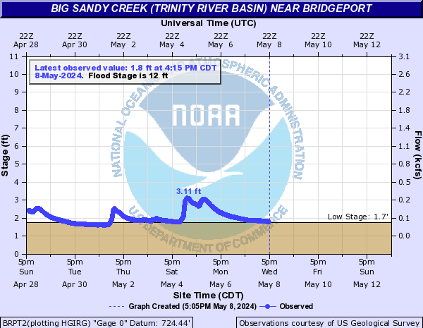
Big Sandy Creek (Trinity River Basin) (Click on an image to go to hydrograph webpage)
BRPT2:
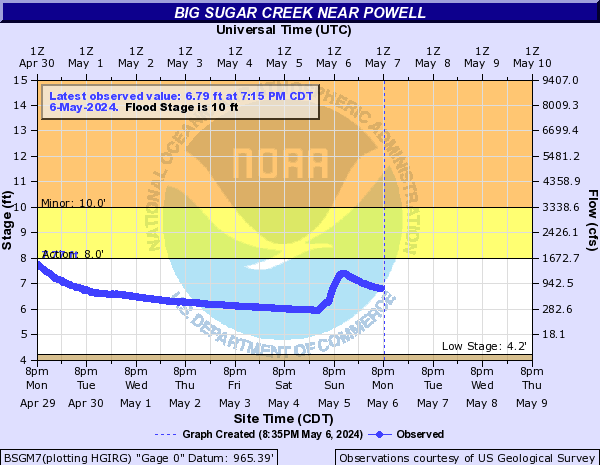
Big Sugar Creek (Click on an image to go to hydrograph webpage)
BSGM7:
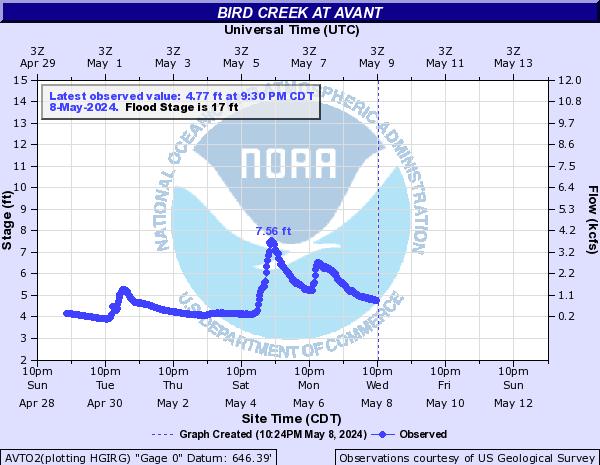
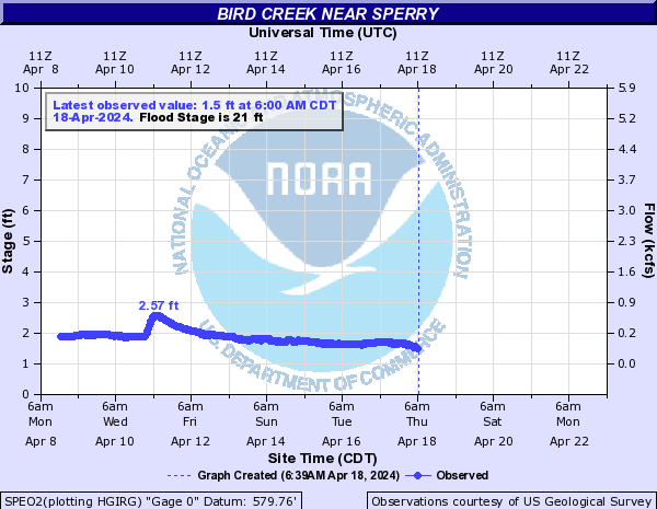
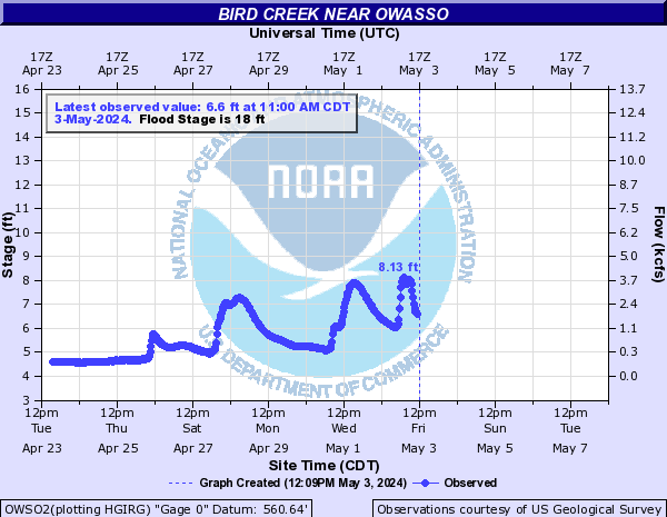
Bird Creek (Click on an image to go to hydrograph webpage)
AVTO2:
SPEO2:
OWSO2:
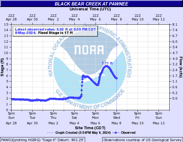
Black Bear Creek (Click on an image to go to hydrograph webpage)
PAWO2:
Black Bear Creek (SC OK) (Click on an image to go to hydrograph webpage)
FUQO2:

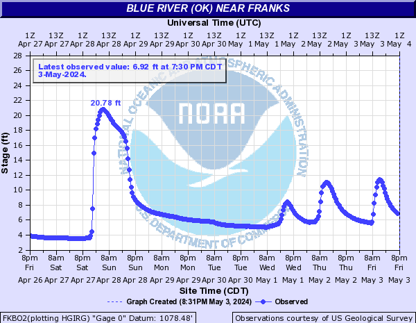
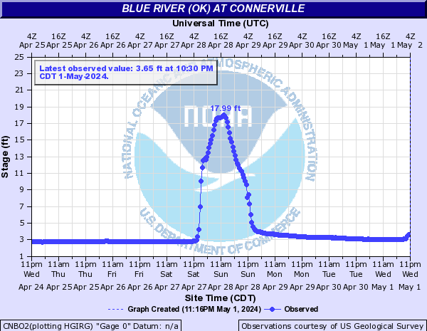
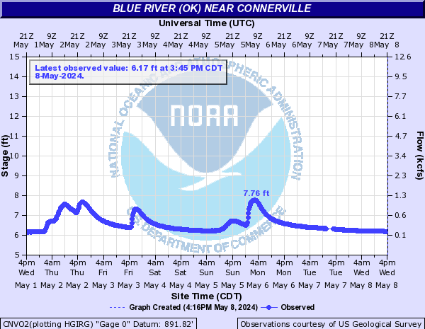
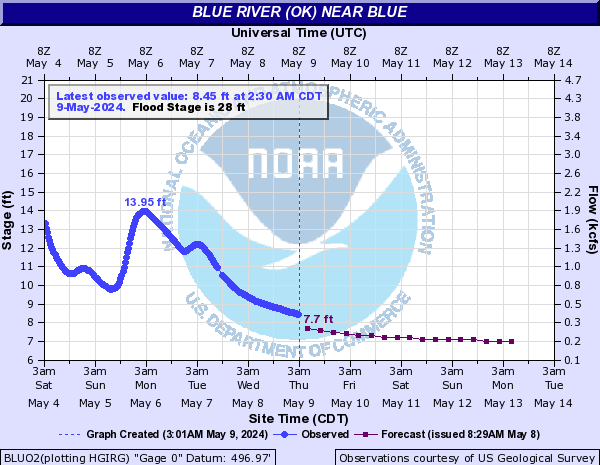
Blue River (OK) (Click on an image to go to hydrograph webpage)
FKBO2:
CNBO2:
CNVO2:
BLUO2:
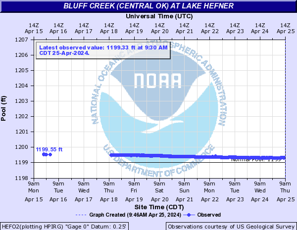
Bluff Creek (Central OK) (Click on an image to go to hydrograph webpage)
HEFO2:
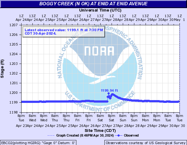
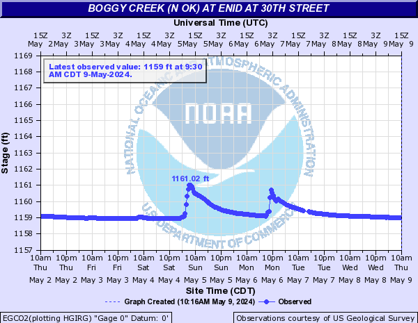
Boggy Creek (N OK) (Click on an image to go to hydrograph webpage)
EBCO2:
EGCO2:
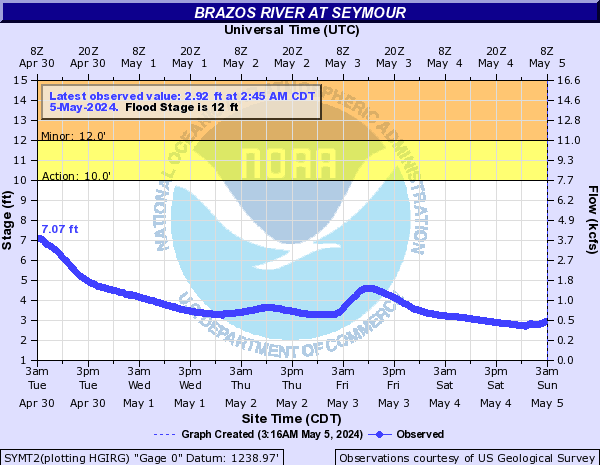
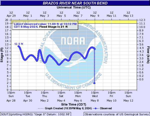
Brazos River (Click on an image to go to hydrograph webpage)
SYMT2:
SOUT2:
Bryant Creek (Click on an image to go to hydrograph webpage)
TBCM7:

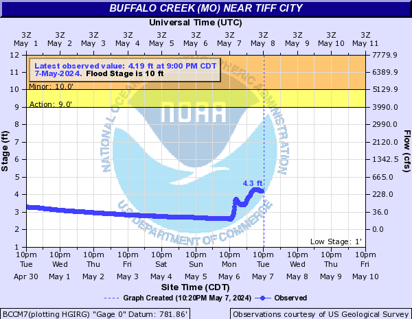
Buffalo Creek (MO) (Click on an image to go to hydrograph webpage)
BCCM7:
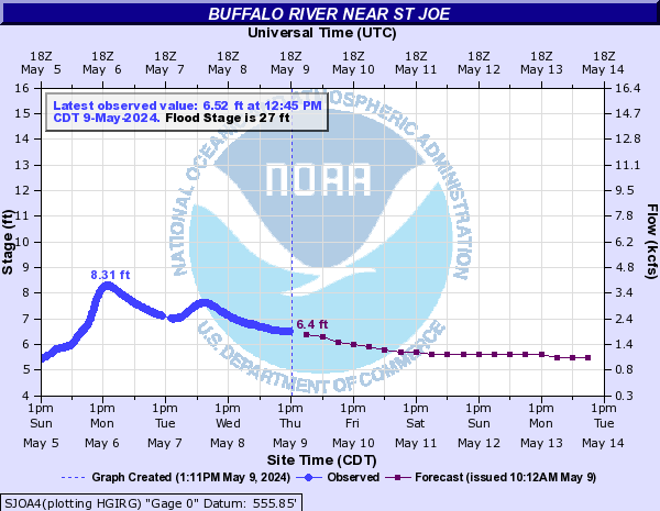
Buffalo River (Click on an image to go to hydrograph webpage)
SJOA4:
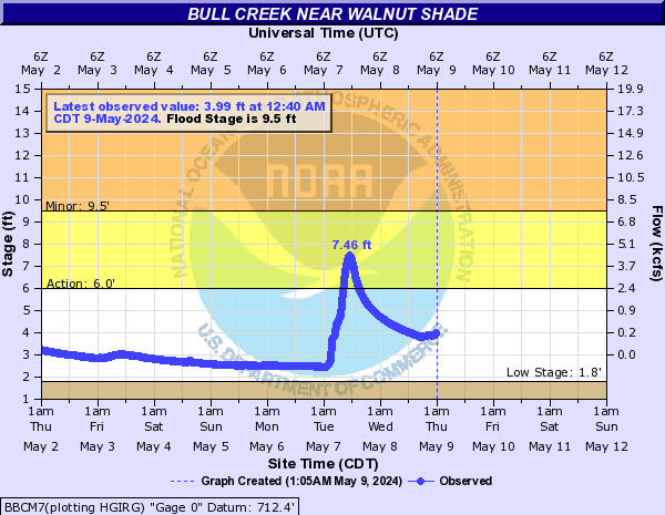
Bull Creek (Click on an image to go to hydrograph webpage)
BBCM7:
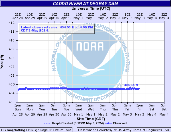
Caddo River (Click on an image to go to hydrograph webpage)
DGDA4:
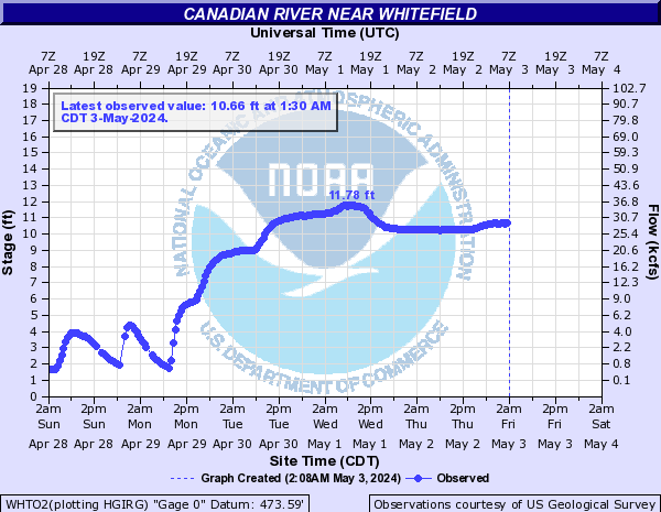
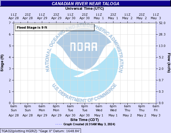
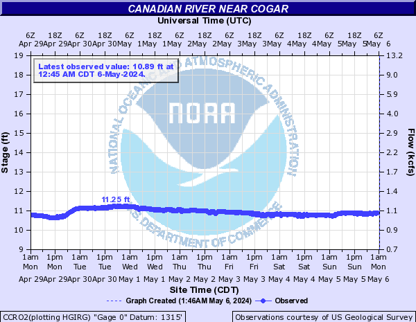
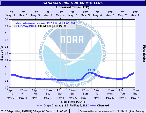
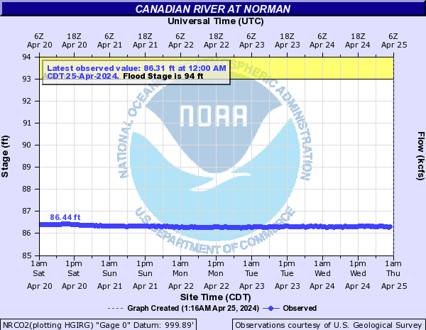
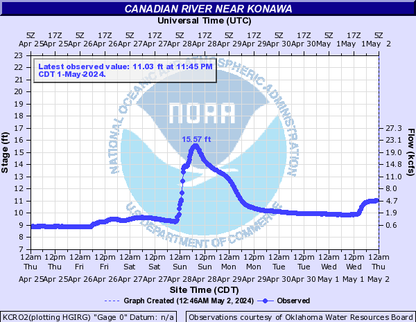
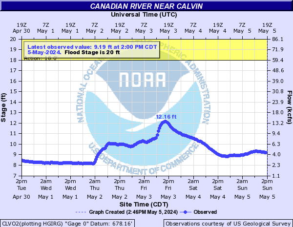
Canadian River (Click on an image to go to hydrograph webpage)
WHTO2:
TGAO2:
BRIO2:
CCRO2:
TUCO2:
NRCO2:
PRCO2:

KCRO2:
CLVO2:
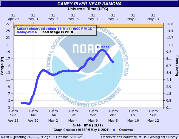
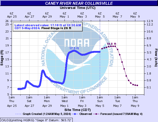
Caney River (Click on an image to go to hydrograph webpage)
BVLO2:

RAMO2:
CVLO2:
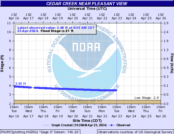
Cedar Creek (Click on an image to go to hydrograph webpage)
PVUM7:
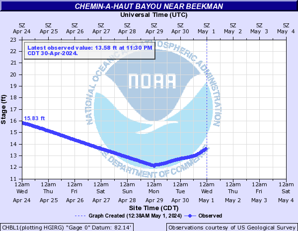
Chemin-a-haut Bayou (Click on an image to go to hydrograph webpage)
CHBL1:
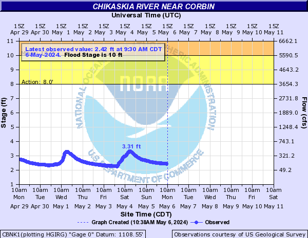
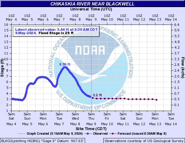
Chikaskia River (Click on an image to go to hydrograph webpage)
CBNK1:
BLKO2:
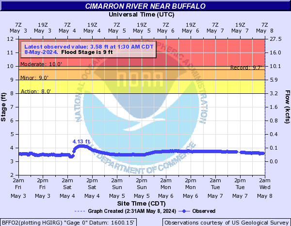
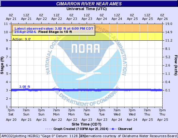
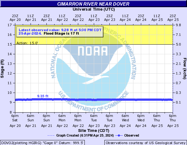
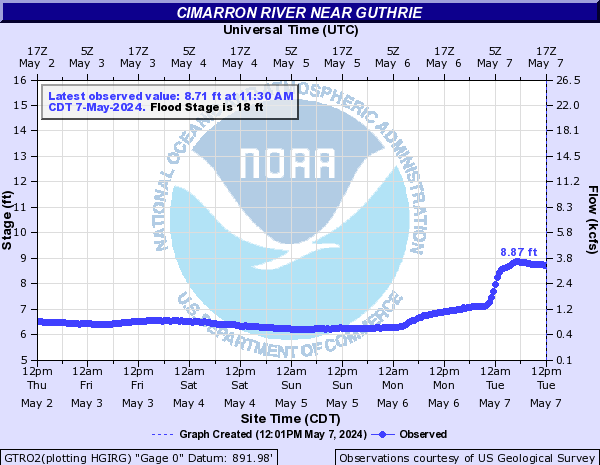
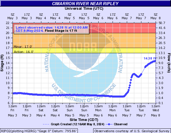
Cimarron River (Click on an image to go to hydrograph webpage)
BFFO2:
WANO2:

AMCO2:
DOVO2:
GTRO2:
PRKO2:

RIPO2:
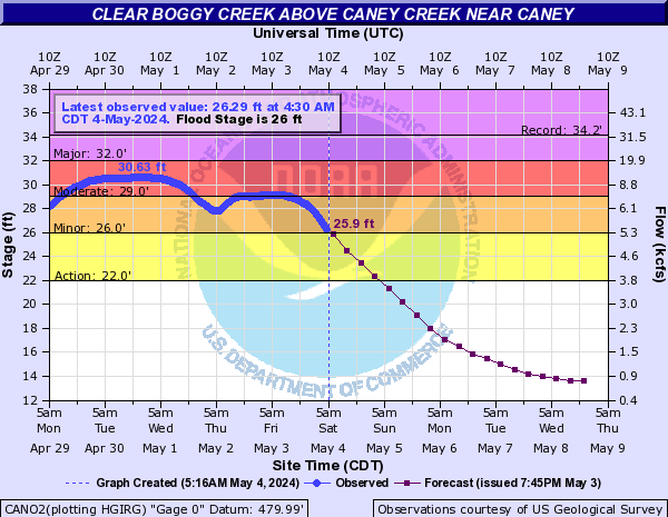
Clear Boggy Creek (Click on an image to go to hydrograph webpage)
CANO2:
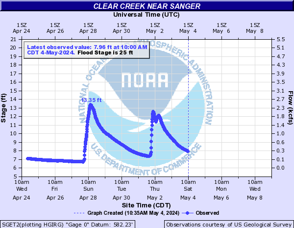
Clear Creek (Click on an image to go to hydrograph webpage)
SGET2:
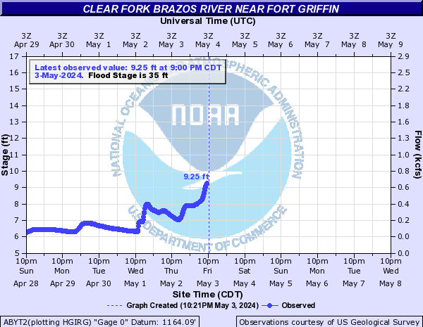
Clear Fork Brazos River (Click on an image to go to hydrograph webpage)
ABYT2:
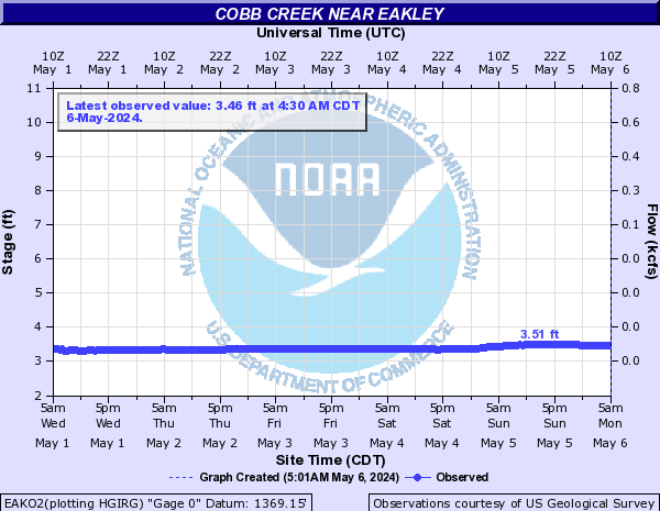
Cobb Creek (Click on an image to go to hydrograph webpage)
EAKO2:
FTCO2:

FCCO2:

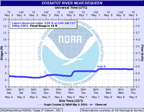
Cossatot River (Click on an image to go to hydrograph webpage)
DEQA4:
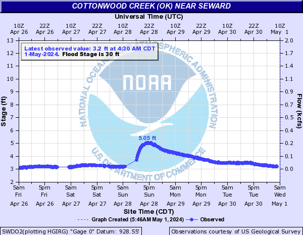
Cottonwood Creek (OK) (Click on an image to go to hydrograph webpage)
SWDO2:
GUCO2:

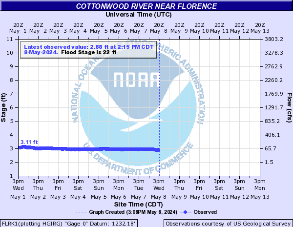
Cottonwood River (Click on an image to go to hydrograph webpage)
FLRK1:
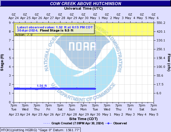
Cow Creek (Click on an image to go to hydrograph webpage)
HTCK1:
Cow Creek (OK) (Click on an image to go to hydrograph webpage)
ADDO2:

Cowleech Fork Sabine River (Click on an image to go to hydrograph webpage)
GNVT2:

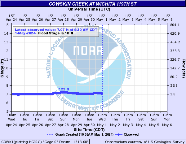
Cowskin Creek (Click on an image to go to hydrograph webpage)
COWK1:
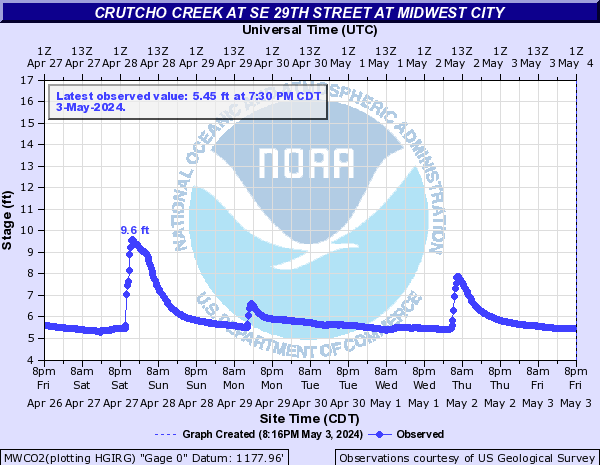
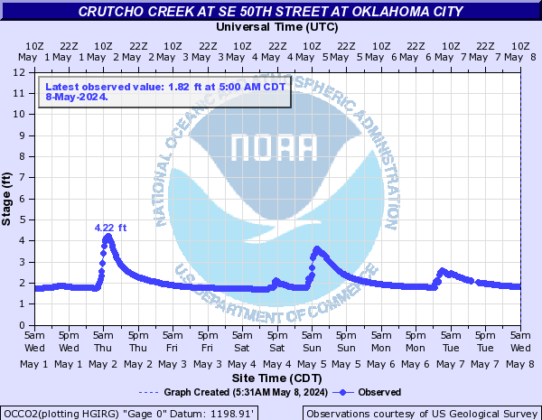
Crutcho Creek (Click on an image to go to hydrograph webpage)
MWCO2:
OCCO2:
Current River (Click on an image to go to hydrograph webpage)
MSPM7:

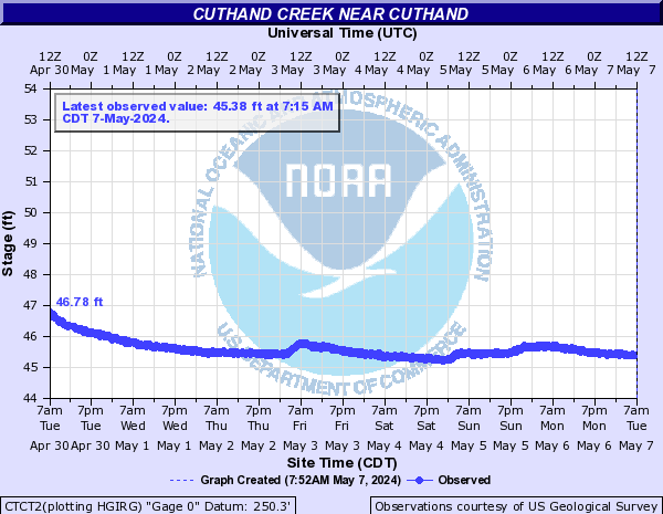
Cuthand Creek (Click on an image to go to hydrograph webpage)
CTCT2:
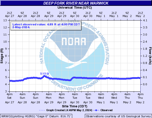
Deep Fork River (Click on an image to go to hydrograph webpage)
ACDO2:

BGSO2:

WRWO2:
SDFO2:

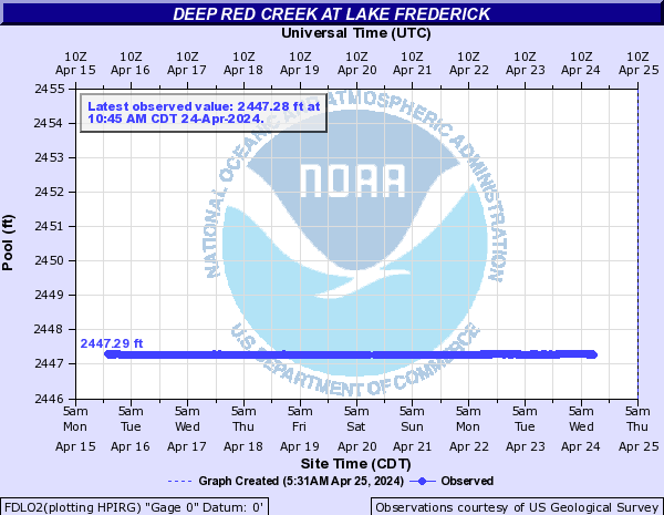
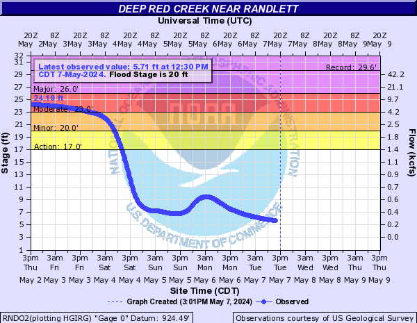
Deep Red Creek (Click on an image to go to hydrograph webpage)
FDLO2:
RNDO2:
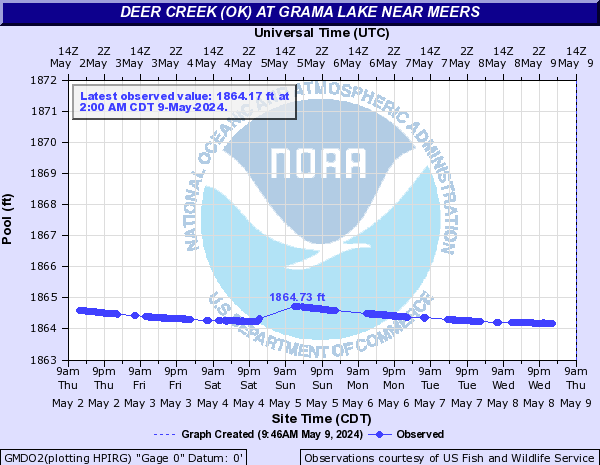
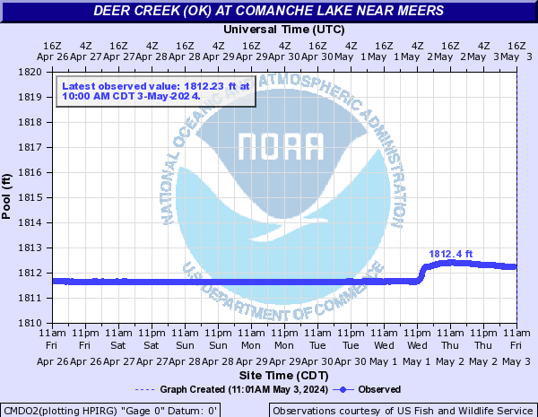
Deer Creek (OK) (Click on an image to go to hydrograph webpage)
GMDO2:
CMDO2:
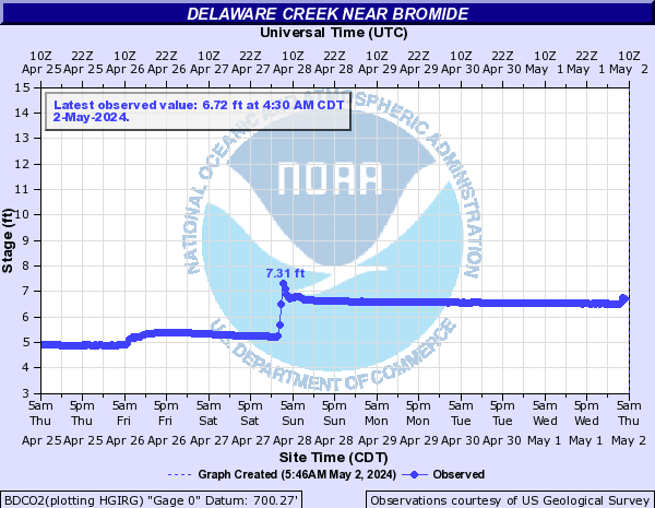
Delaware Creek (Click on an image to go to hydrograph webpage)
BDCO2:
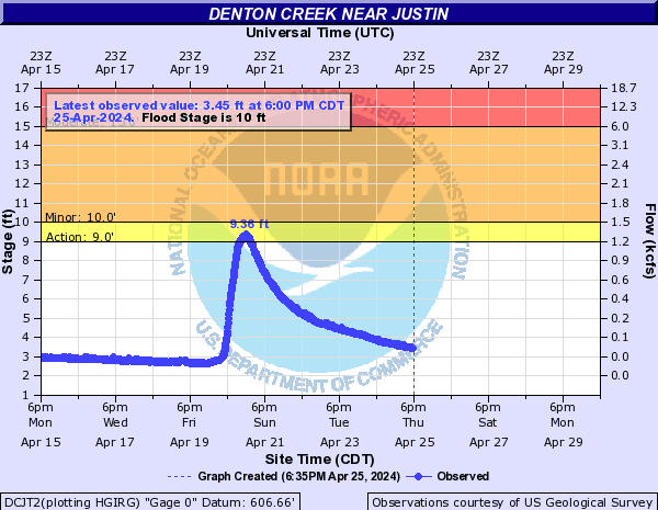
Denton Creek (Click on an image to go to hydrograph webpage)
DCJT2:
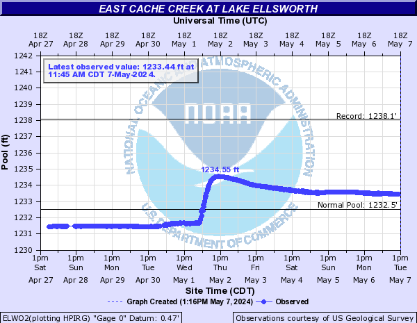
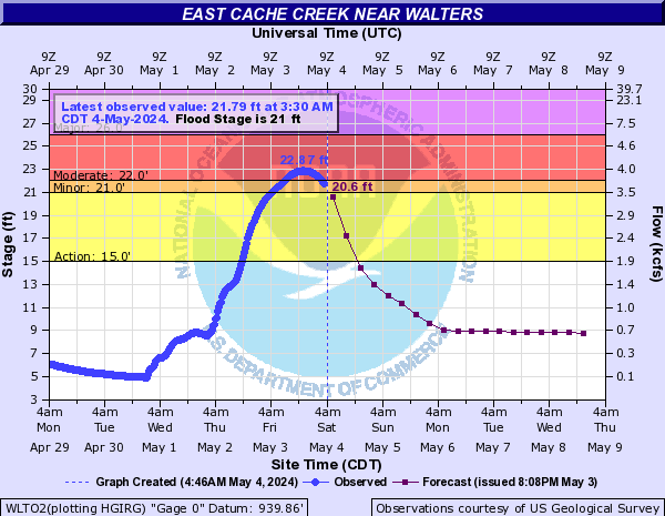
East Cache Creek (Click on an image to go to hydrograph webpage)
ELWO2:
WLTO2:
East Elm Creek (Click on an image to go to hydrograph webpage)
LSDO2:

East Fork Drywood Creek (Click on an image to go to hydrograph webpage)
DWEM7:

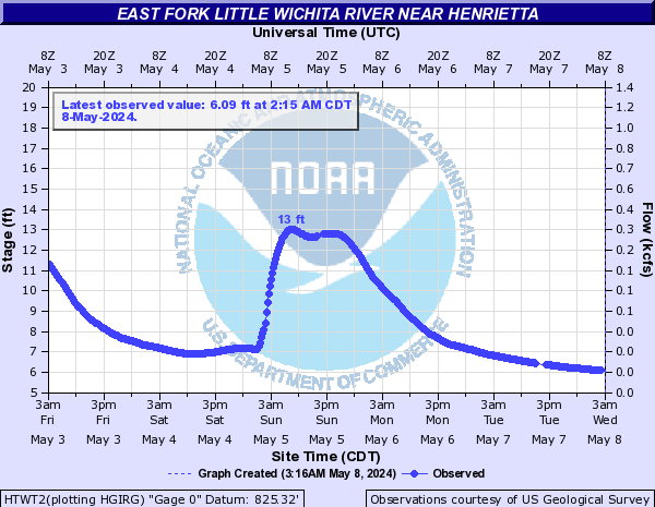
East Fork Little Wichita River (Click on an image to go to hydrograph webpage)
HTWT2:
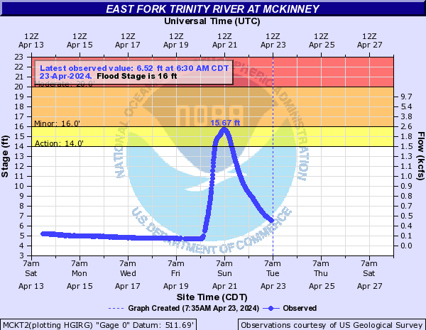
East Fork Trinity River (Click on an image to go to hydrograph webpage)
MCKT2:
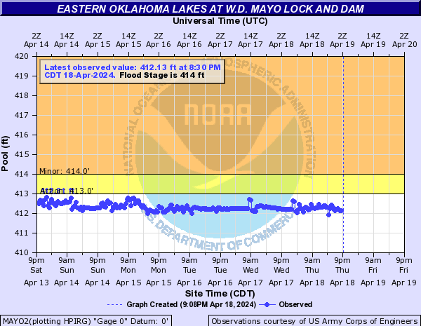
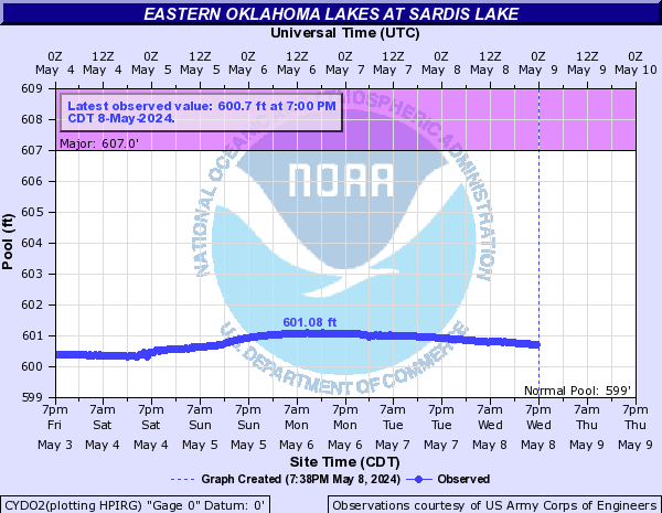
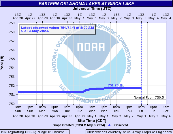
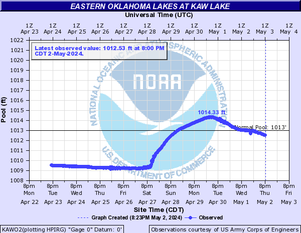
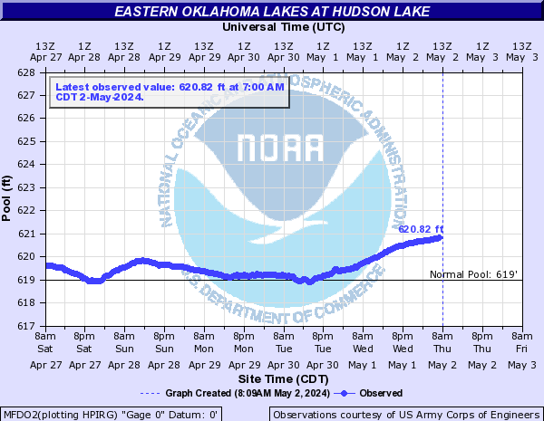
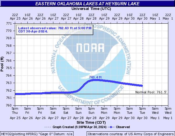
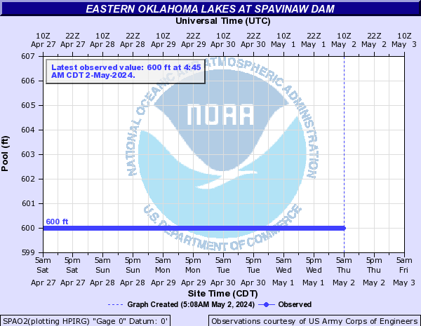
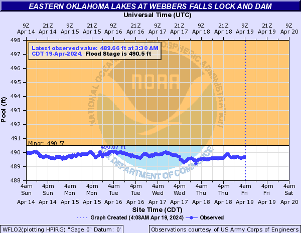
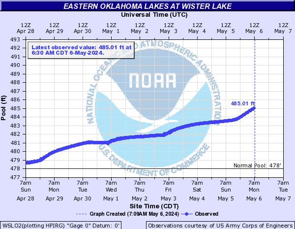
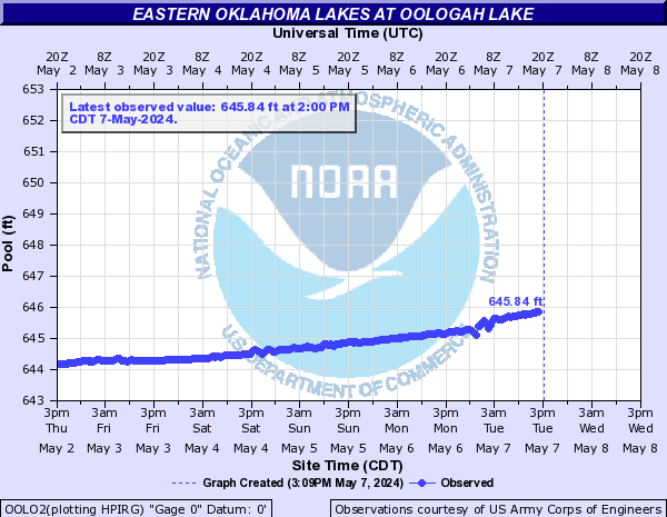
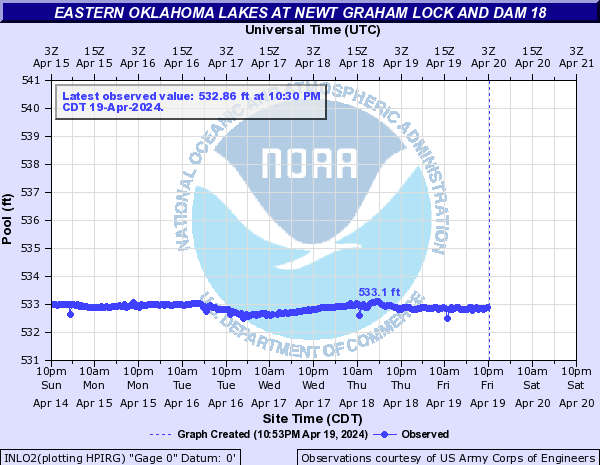
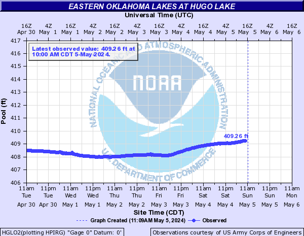
Eastern Oklahoma Lakes (Click on an image to go to hydrograph webpage)
PENO2:

MAYO2:
CYDO2:
KEYO2:

GIBO2:

WAGO2:

TENO2:

CPLO2:

BIRO2:
EUFO2:

SKLO2:

KERO2:

KAWO2:
MFDO2:
NNEO2:

HEYO2:
HULO2:

SPAO2:
WFLO2:
WSLO2:
OOLO2:
INLO2:
HGLO2:
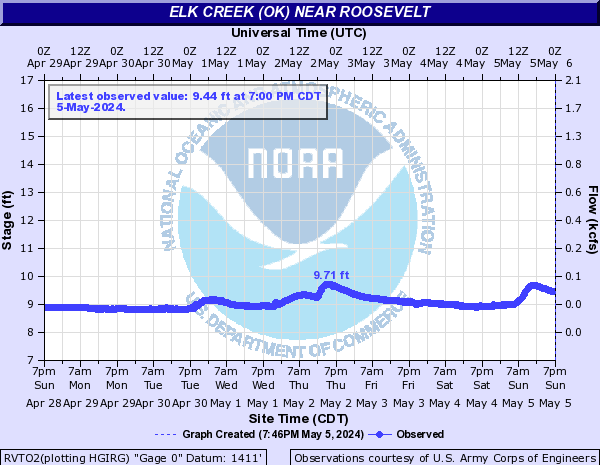
Elk Creek (OK) (Click on an image to go to hydrograph webpage)
RVTO2:
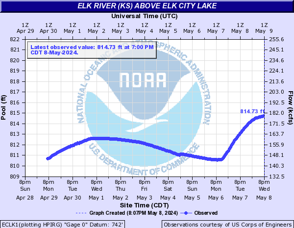
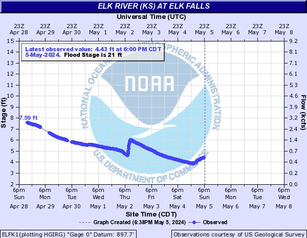
Elk River (KS) (Click on an image to go to hydrograph webpage)
ECLK1:
ELFK1:
Elk River (MO) (Click on an image to go to hydrograph webpage)
TIFM7:

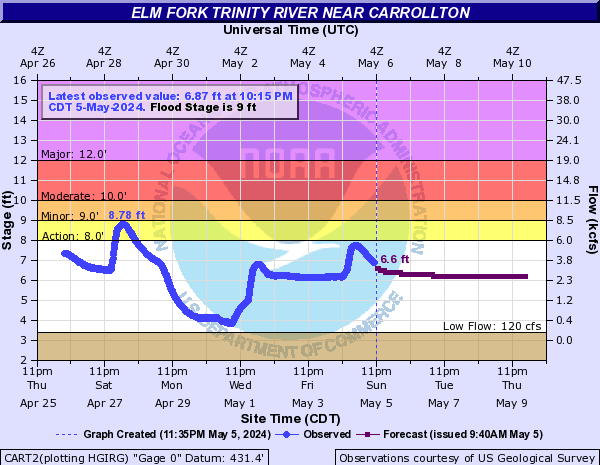
Elm Fork Trinity River (Click on an image to go to hydrograph webpage)
GLLT2:

CART2:
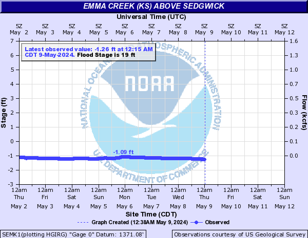
Emma Creek (KS) (Click on an image to go to hydrograph webpage)
SEMK1:
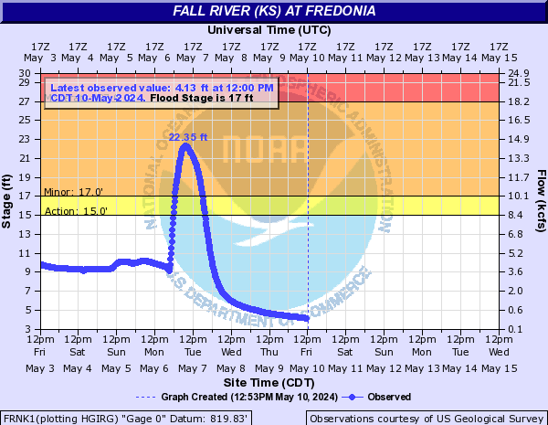
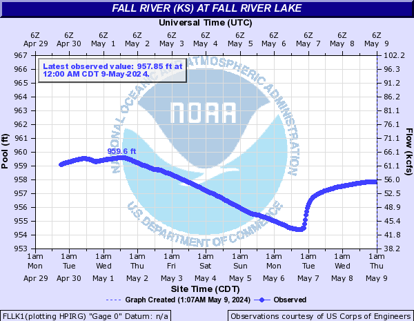
Fall River (KS) (Click on an image to go to hydrograph webpage)
FRNK1:
FLLK1:
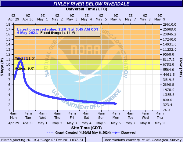
Finley River (Click on an image to go to hydrograph webpage)
FINM7:
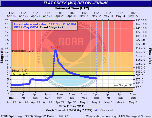
Flat Creek (MO) (Click on an image to go to hydrograph webpage)
FCRM7:
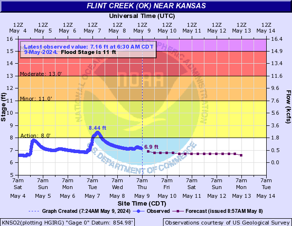
Flint Creek (OK) (Click on an image to go to hydrograph webpage)
KNSO2:
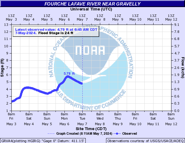
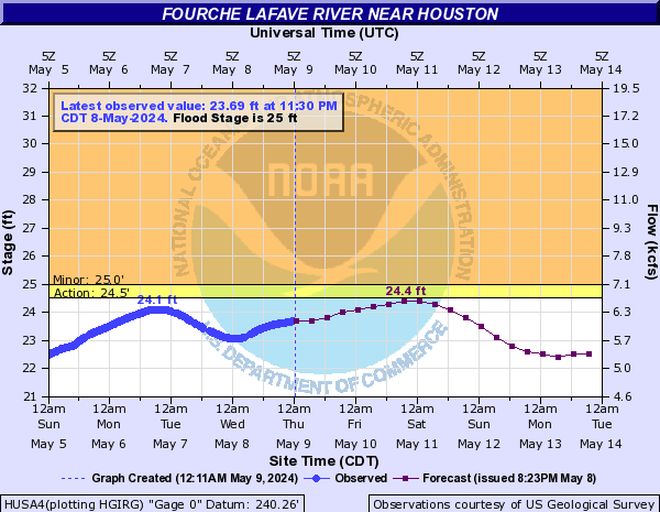
Fourche LaFave River (Click on an image to go to hydrograph webpage)
GRVA4:
HUSA4:
NMLA4:

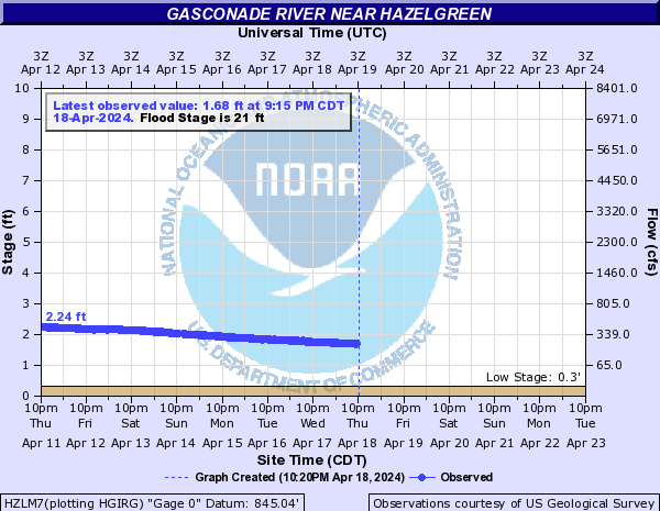
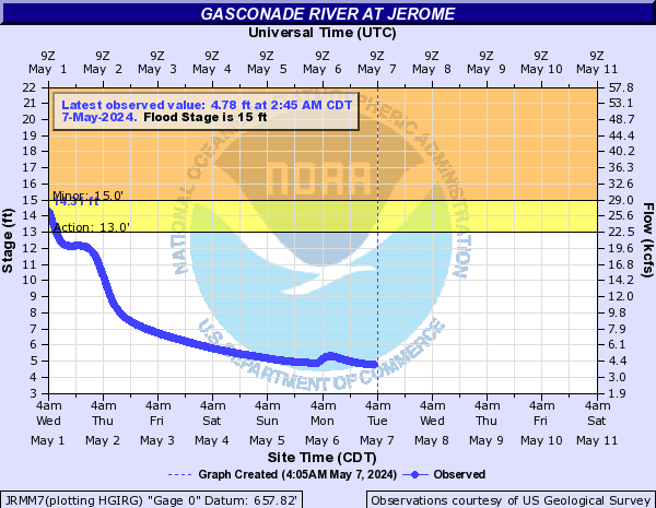
Gasconade River (Click on an image to go to hydrograph webpage)
HZLM7:
JRMM7:
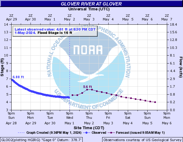
Glover River (Click on an image to go to hydrograph webpage)
GLOO2:
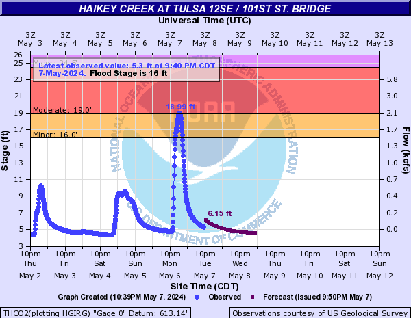
Haikey Creek (Click on an image to go to hydrograph webpage)
THCO2:
Holliday Creek (Click on an image to go to hydrograph webpage)
WFHT2:

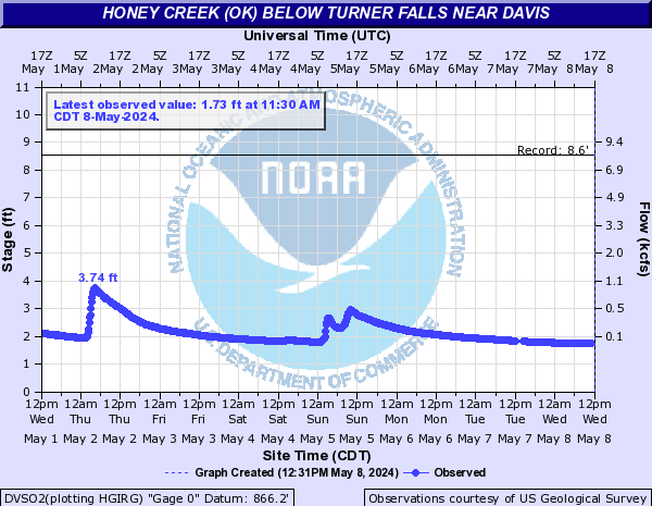
Honey Creek (OK) (Click on an image to go to hydrograph webpage)
DVSO2:
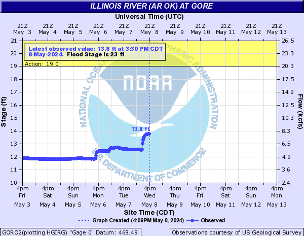
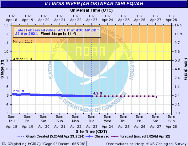
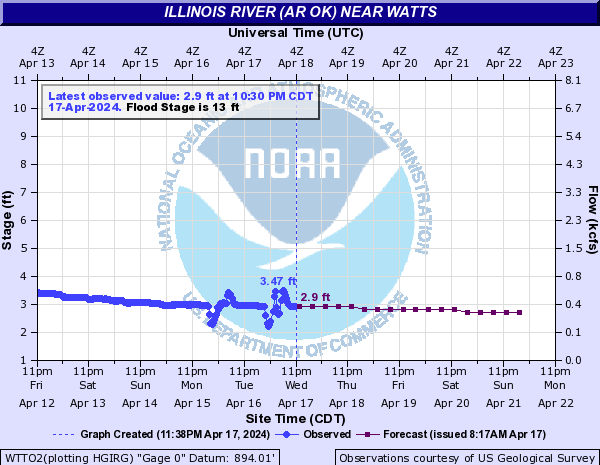
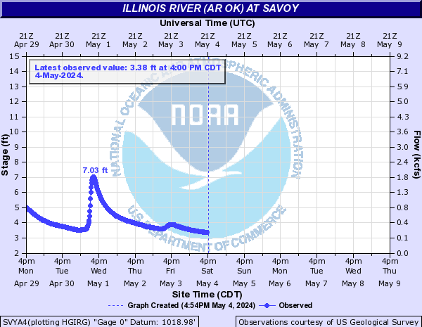
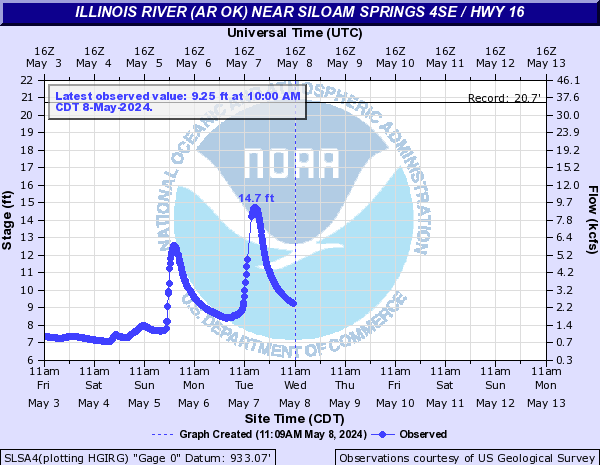
Illinois River (AR OK) (Click on an image to go to hydrograph webpage)
GORO2:
TALO2:
WTTO2:
CWYO2:

SVYA4:
SLSA4:
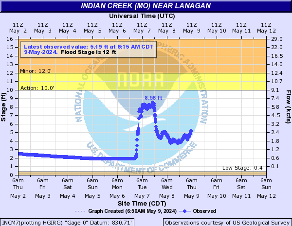
Indian Creek (MO) (Click on an image to go to hydrograph webpage)
INCM7:
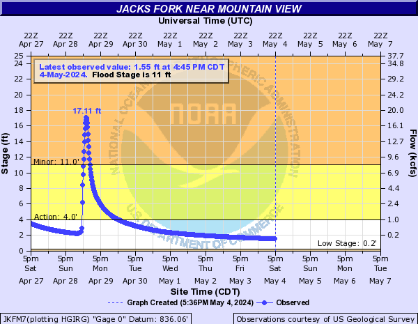
Jacks Fork (Click on an image to go to hydrograph webpage)
JKFM7:
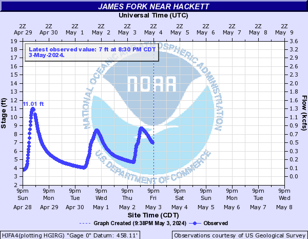
James Fork (Click on an image to go to hydrograph webpage)
HJFA4:
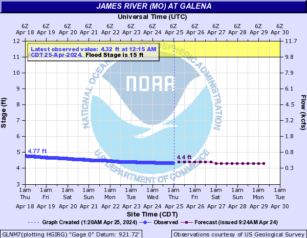
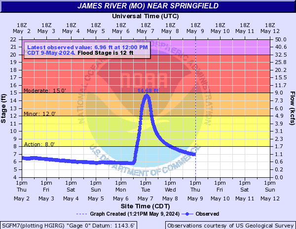
James River (MO) (Click on an image to go to hydrograph webpage)
GLNM7:
JAMM7:
SGFM7:
Joe Creek (Click on an image to go to hydrograph webpage)
TJOO2:

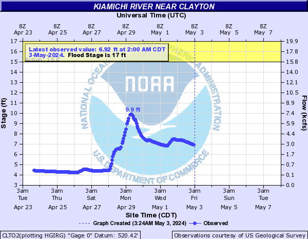
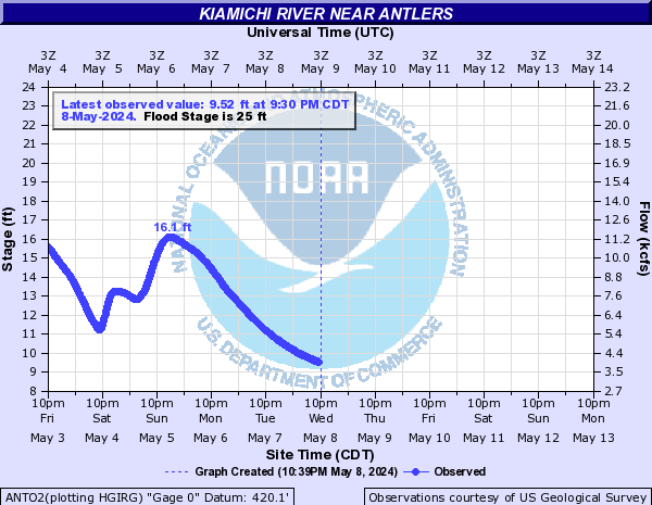
Kiamichi River (Click on an image to go to hydrograph webpage)
CLTO2:
ANTO2:
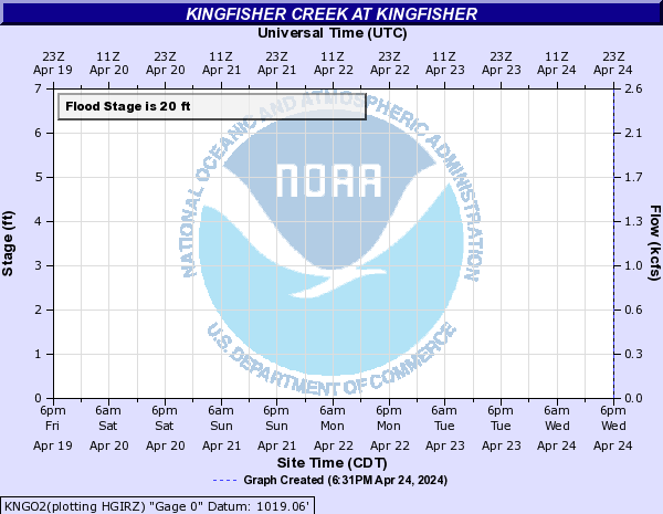
Kingfisher Creek (Click on an image to go to hydrograph webpage)
KNGO2:
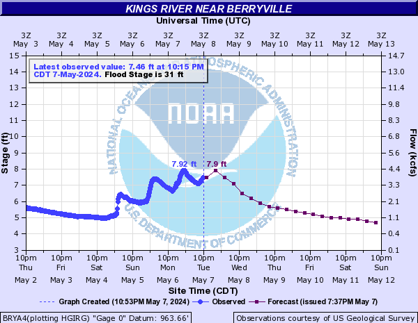
Kings River (Click on an image to go to hydrograph webpage)
BRYA4:
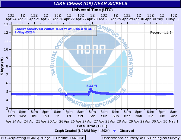
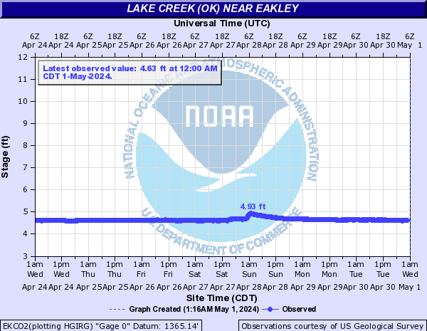
Lake Creek (OK) (Click on an image to go to hydrograph webpage)
HLCO2:
EKCO2:
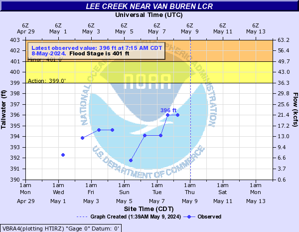
Lee Creek (Click on an image to go to hydrograph webpage)
VBRA4:
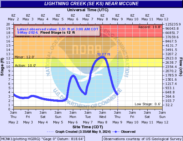
Lightning Creek (SE KS) (Click on an image to go to hydrograph webpage)
MCNK1:
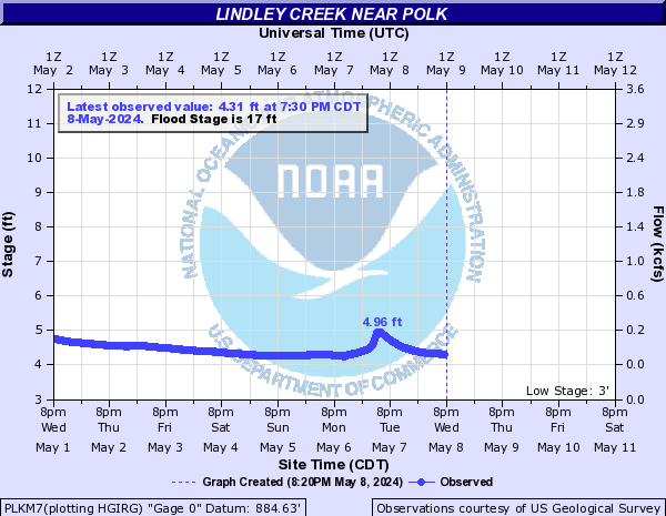
Lindley Creek (Click on an image to go to hydrograph webpage)
PLKM7:
Little Arkansas River (Click on an image to go to hydrograph webpage)
ALMK1:

HTDK1:
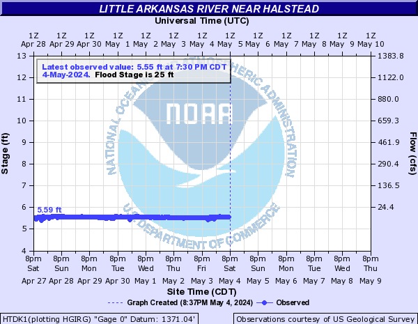
SEDK1:
Little Beaver Creek (OK) (Click on an image to go to hydrograph webpage)
DLBO2:
Little Missouri River (AR) (Click on an image to go to hydrograph webpage)
BHTA4:

NADA4:

Little Niangua River (Click on an image to go to hydrograph webpage)
LNIM7:
Little North Fork River (Click on an image to go to hydrograph webpage)
TFDM7:
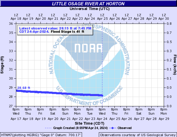
Little Osage River (Click on an image to go to hydrograph webpage)
FTNK1:

HTNM7:
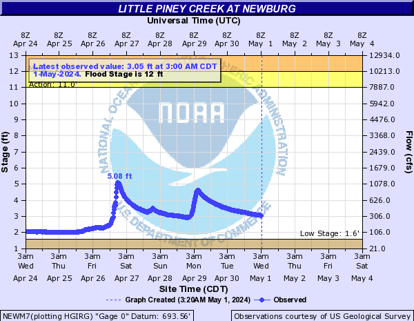
Little Piney Creek (Click on an image to go to hydrograph webpage)
NEWM7:
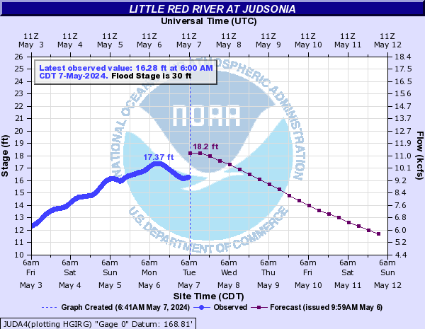
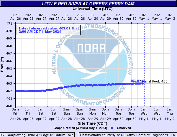
Little Red River (Click on an image to go to hydrograph webpage)
JUDA4:
GRRA4:
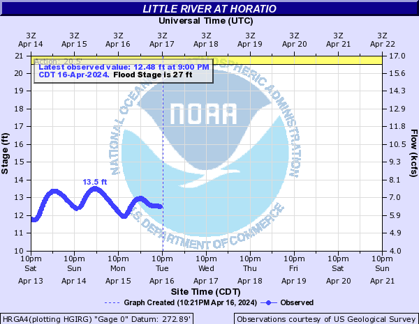
Little River (Click on an image to go to hydrograph webpage)
IDBO2:

HRGA4:
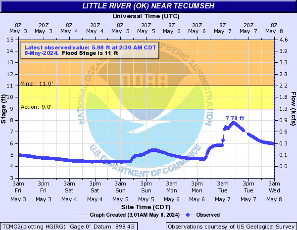
Little River (OK) (Click on an image to go to hydrograph webpage)
NRMO2:
NLRO2:

TCMO2:
SASO2:

Little Sac River (Click on an image to go to hydrograph webpage)
MSZM7:

Little Sugar Creek (Click on an image to go to hydrograph webpage)
LSGM7:

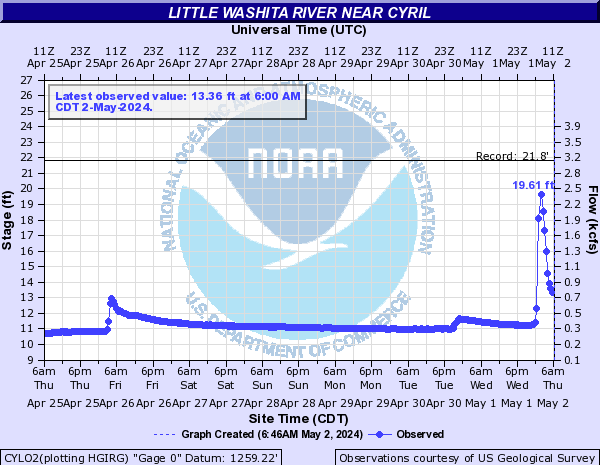
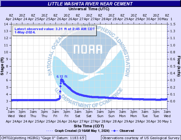
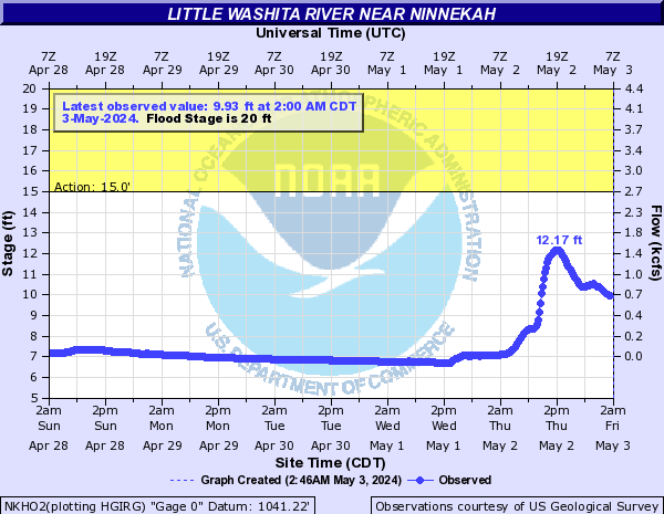
Little Washita River (Click on an image to go to hydrograph webpage)
CYLO2:
CMTO2:
NKHO2:
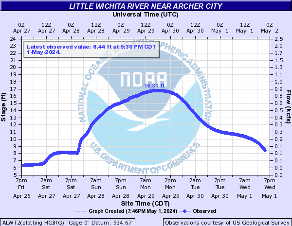
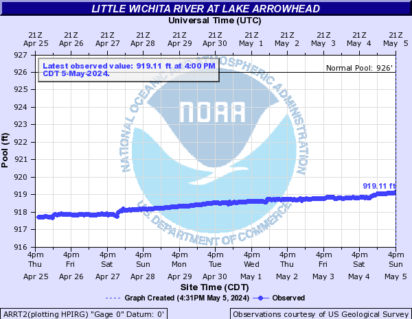
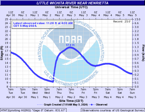
Little Wichita River (Click on an image to go to hydrograph webpage)
ALWT2:
ARRT2:
HTAT2:
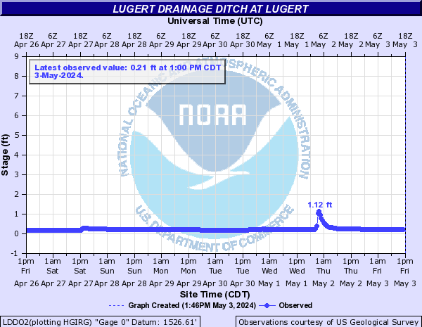
Lugert Drainage Ditch (Click on an image to go to hydrograph webpage)
LDDO2:
Marais Des Cygnes River (Click on an image to go to hydrograph webpage)
TPOK1:

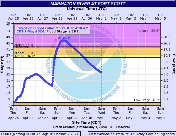
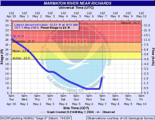
Marmaton River (Click on an image to go to hydrograph webpage)
UUUK1:

FSKK1:
RCCM7:
NVDM7:

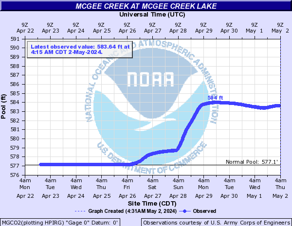
McGee Creek (Click on an image to go to hydrograph webpage)
MGCO2:
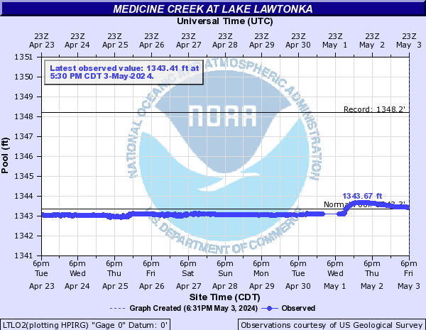
Medicine Creek (Click on an image to go to hydrograph webpage)
LTLO2:
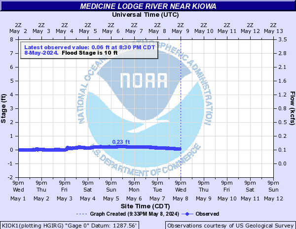
Medicine Lodge River (Click on an image to go to hydrograph webpage)
KIOK1:
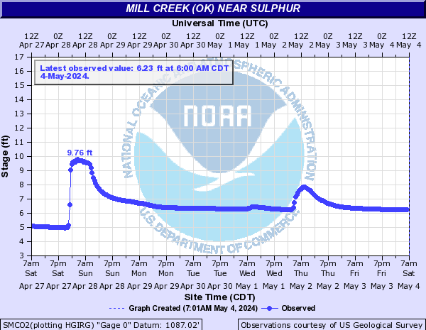
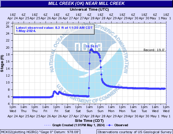
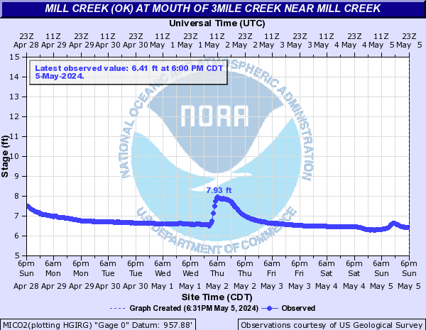
Mill Creek (OK) (Click on an image to go to hydrograph webpage)
SMCO2:
MCKO2:
MICO2:
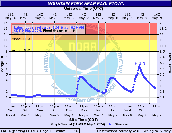
Mountain Fork (Click on an image to go to hydrograph webpage)
EAGO2:
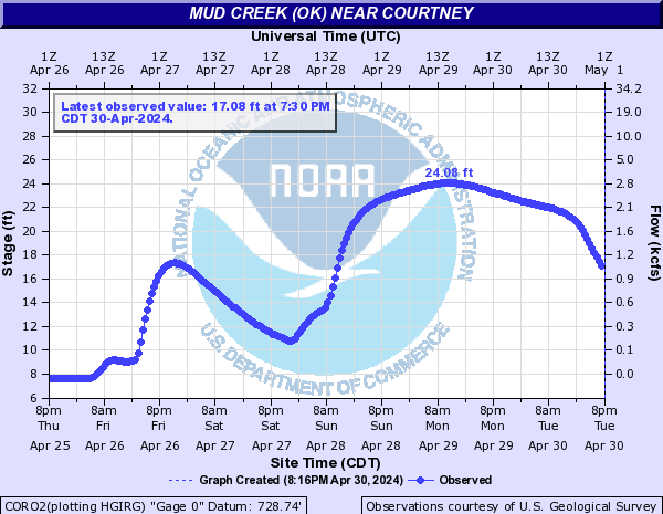
Mud Creek (OK) (Click on an image to go to hydrograph webpage)
CORO2:
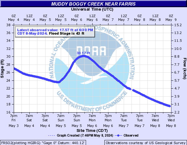
Muddy Boggy Creek (Click on an image to go to hydrograph webpage)
ATMO2:

FRSO2:
Mulberry River (AR) (Click on an image to go to hydrograph webpage)
MLBA4:

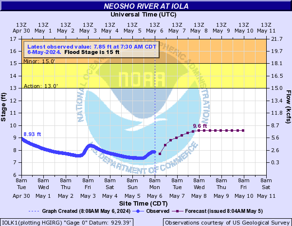
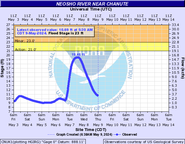
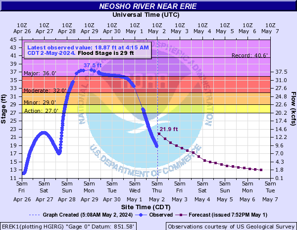
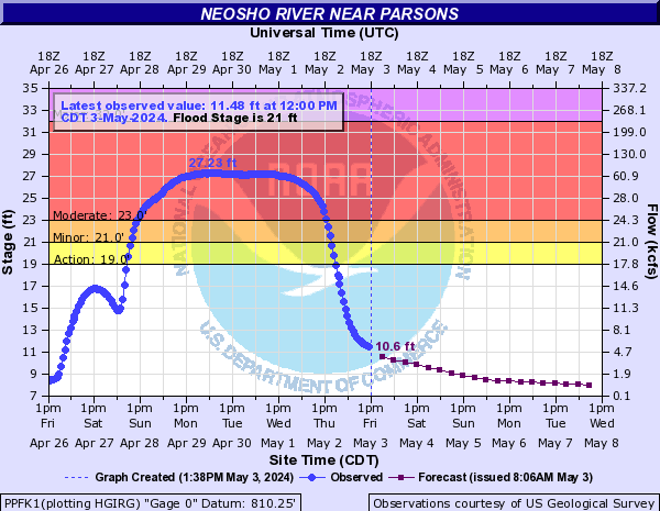
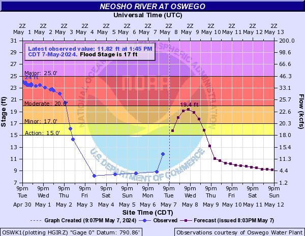
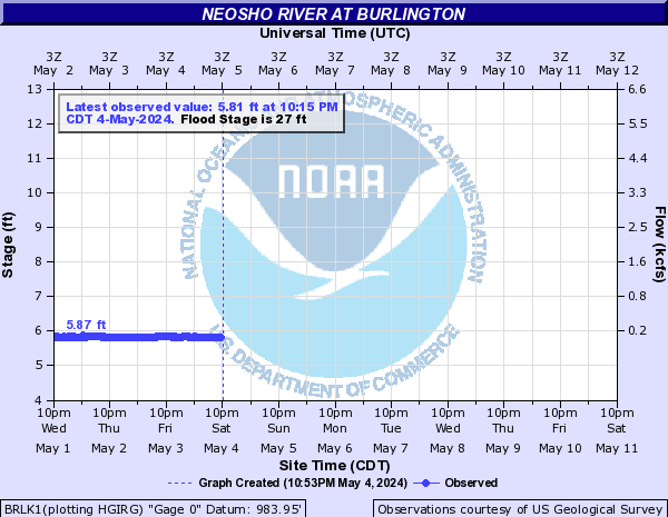
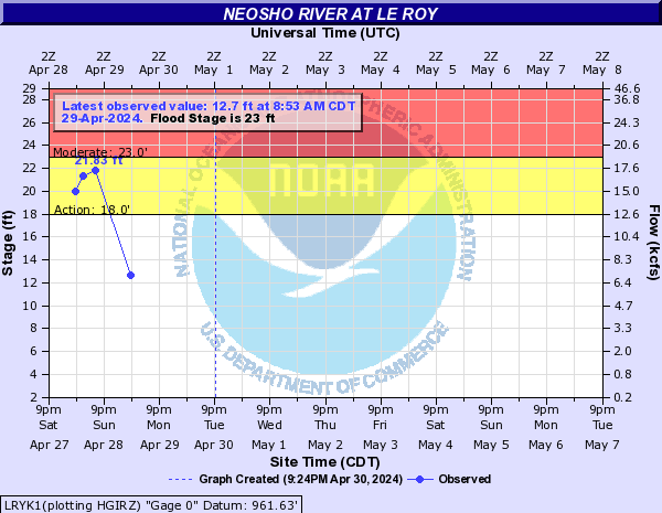
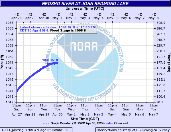
Neosho River (Click on an image to go to hydrograph webpage)
COMO2:
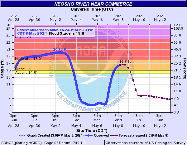
NSOK1:
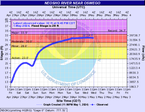
IOLK1:
CNUK1:
EREK1:
PPFK1:
OSWK1:
BRLK1:
LRYK1:
JRLK1:
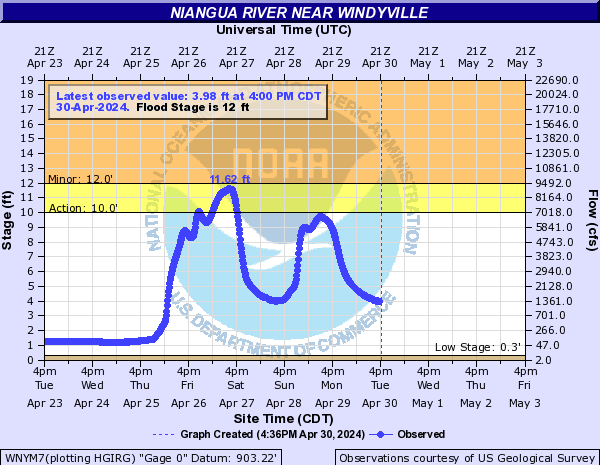
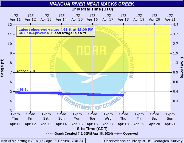
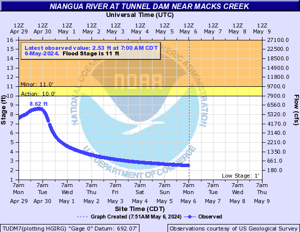
Niangua River (Click on an image to go to hydrograph webpage)
WNYM7:
NMCM7:
TUDM7:
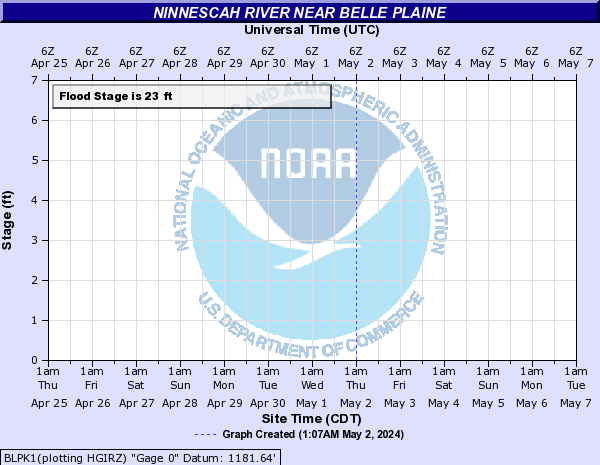
Ninnescah River (Click on an image to go to hydrograph webpage)
CHNK1:

MDKK1:

PECK1:

BLPK1:
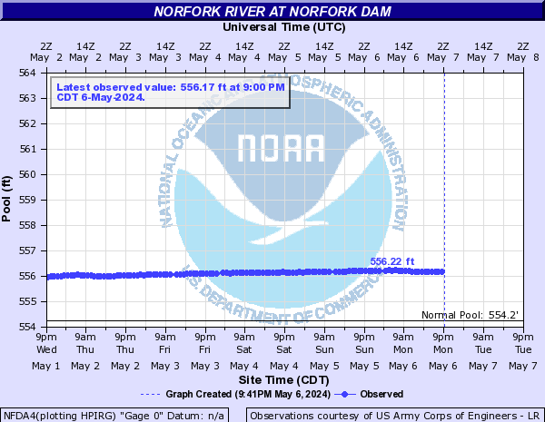
Norfork River (Click on an image to go to hydrograph webpage)
NFDA4:
North Boggy Creek (Click on an image to go to hydrograph webpage)
ATKO2:

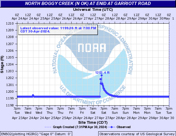
North Boggy Creek (N OK) (Click on an image to go to hydrograph webpage)
ENBO2:
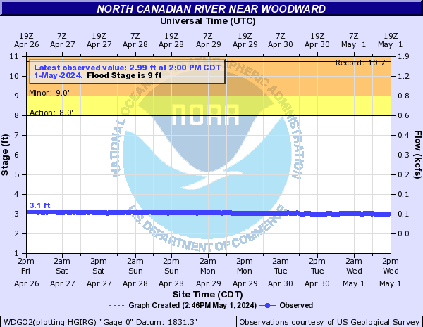
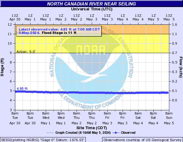
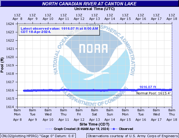
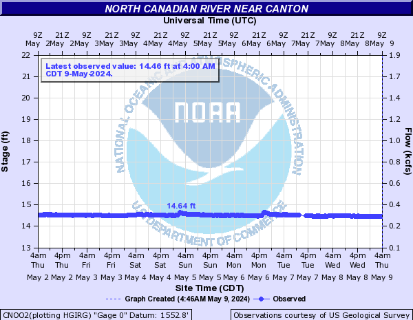
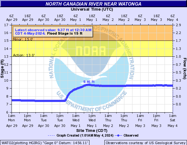
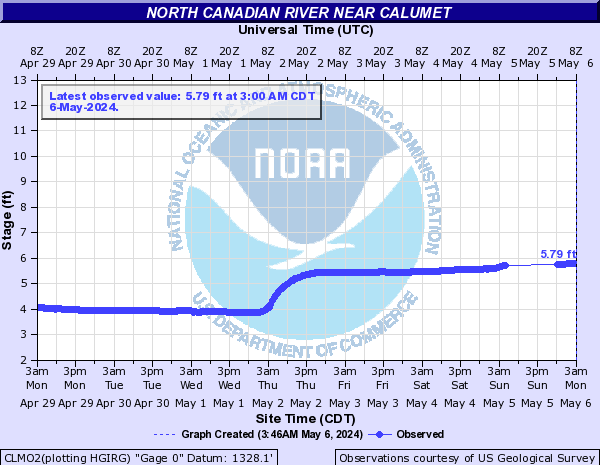
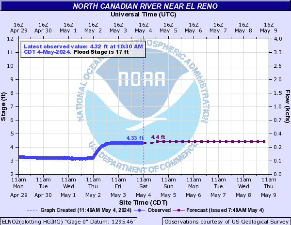
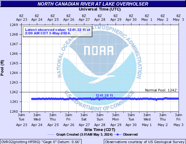
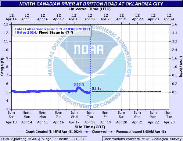
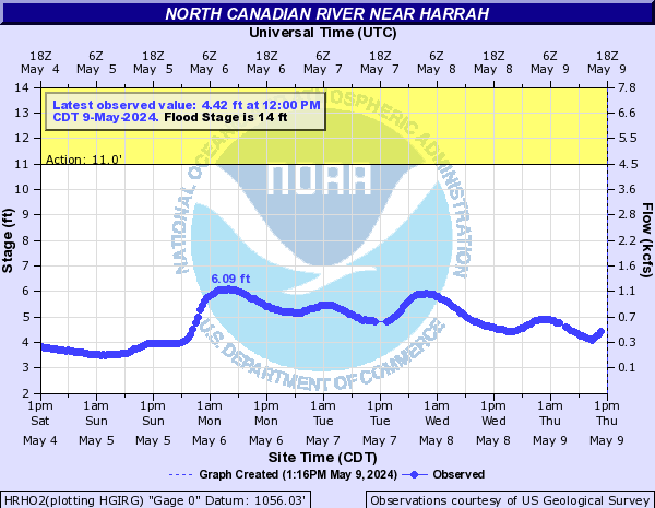
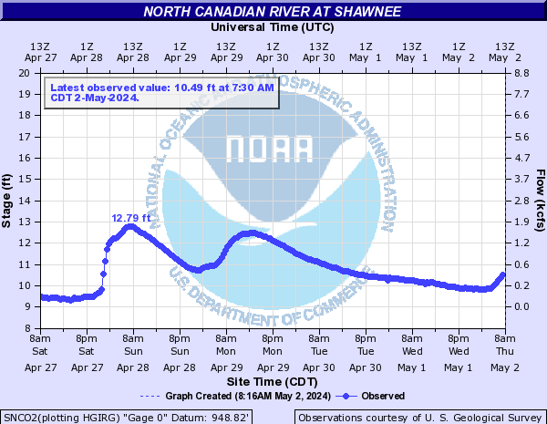
North Canadian River (Click on an image to go to hydrograph webpage)
WDGO2:
SEIO2:
CNLO2:
CNOO2:
WATO2:
CLMO2:
ELNO2:
YUKO2:

OVRO2:
OLBO2:

OKBO2:
HRHO2:
SWNO2:

SNCO2:
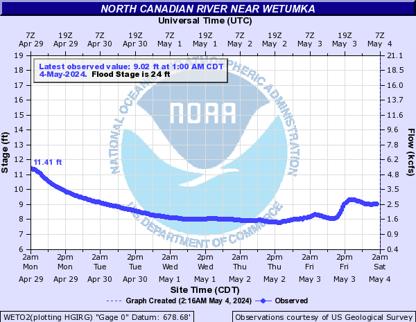
WETO2:
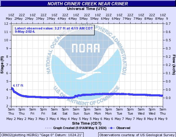
North Criner Creek (Click on an image to go to hydrograph webpage)
CRNO2:
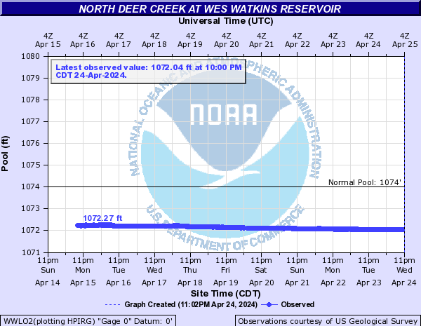
North Deer Creek (Click on an image to go to hydrograph webpage)
WWLO2:
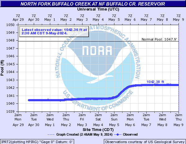
North Fork Buffalo Creek (Click on an image to go to hydrograph webpage)
IPRT2:
North Fork Little Wichita River (Click on an image to go to hydrograph webpage)
ARHT2:
North Fork of the Red River (Click on an image to go to hydrograph webpage)
ALTO2:

LGTO2:
HEAO2:
TIPO2:
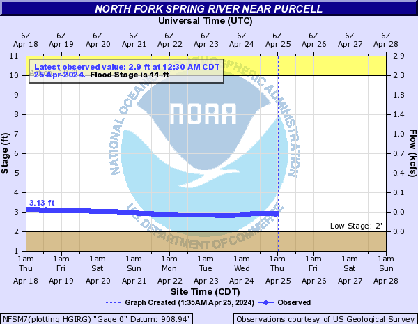
North Fork Spring River (Click on an image to go to hydrograph webpage)
NFSM7:
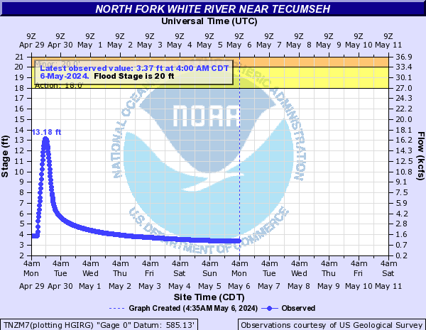
North Fork White River (Click on an image to go to hydrograph webpage)
TNZM7:
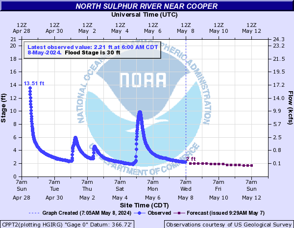
North Sulphur River (Click on an image to go to hydrograph webpage)
CPPT2:
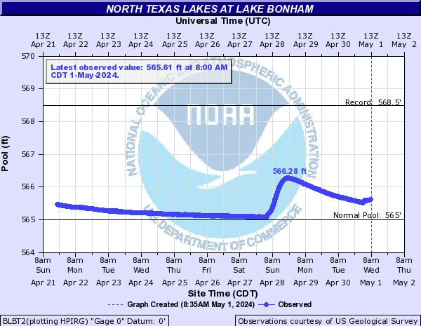
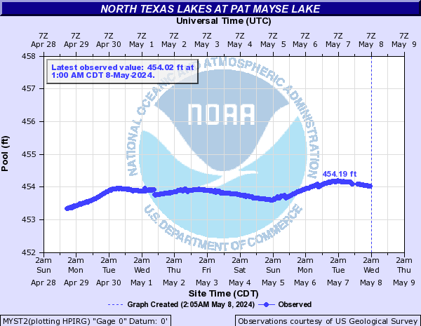
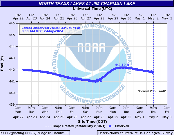
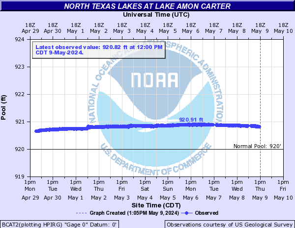
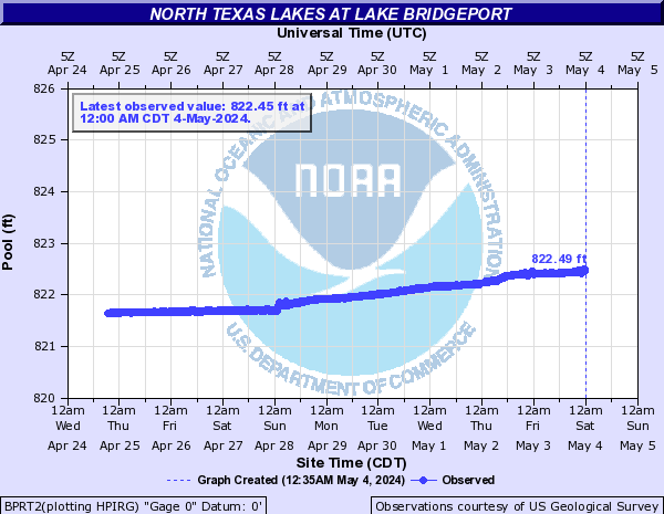
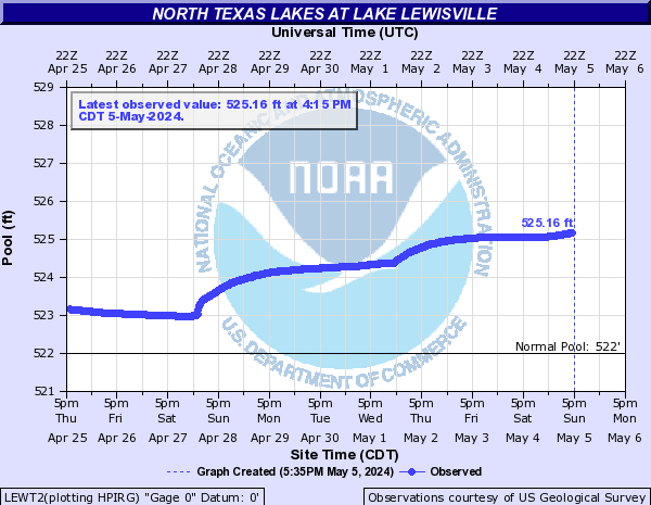
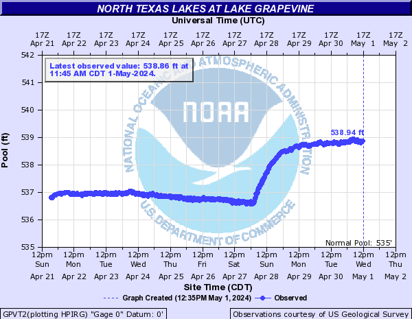
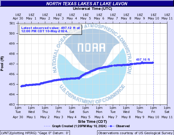
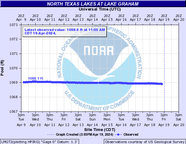
North Texas Lakes (Click on an image to go to hydrograph webpage)
NNCT2:

MFCT2:

BLBT2:
MYST2:
SCLT2:
BCAT2:
LCJT2:

BPRT2:
RRLT2:

LEWT2:
GPVT2:
LVNT2:
LMGT2:
Northwest Arkansas Lakes (Click on an image to go to hydrograph webpage)
BVGA4:

BARA4:

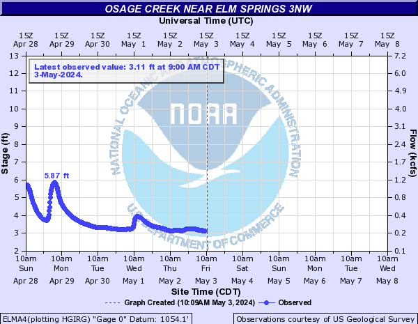
Osage Creek (Click on an image to go to hydrograph webpage)
ELMA4:
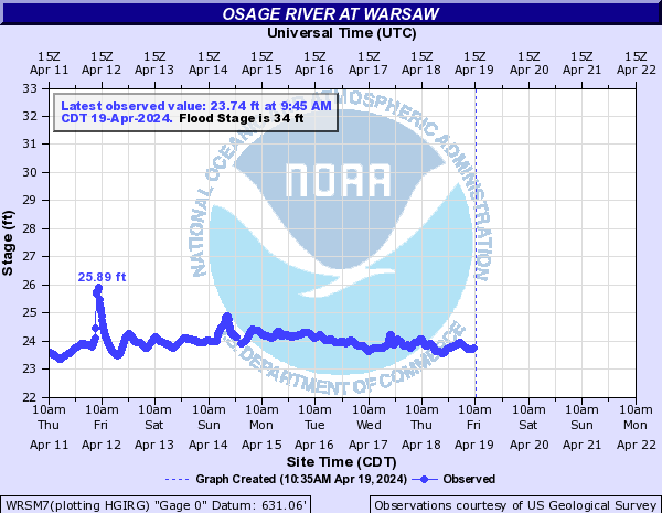
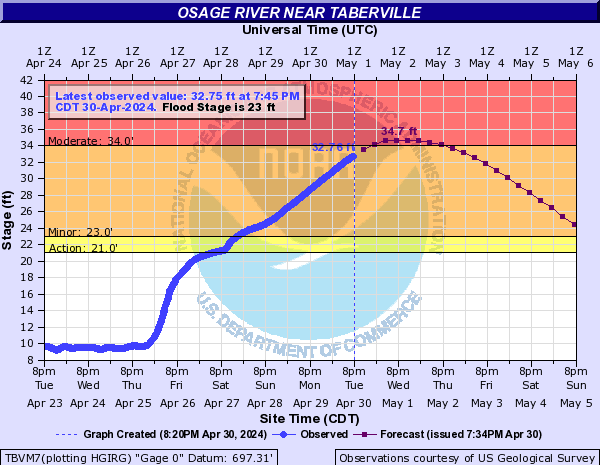
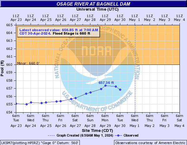
Osage River (Click on an image to go to hydrograph webpage)
WRSM7:
SCZM7:

TBVM7:
LKSM7:
LKBM7:

TSCM7:

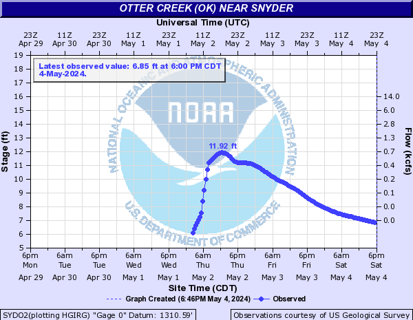
Otter Creek (OK) (Click on an image to go to hydrograph webpage)
SYDO2:
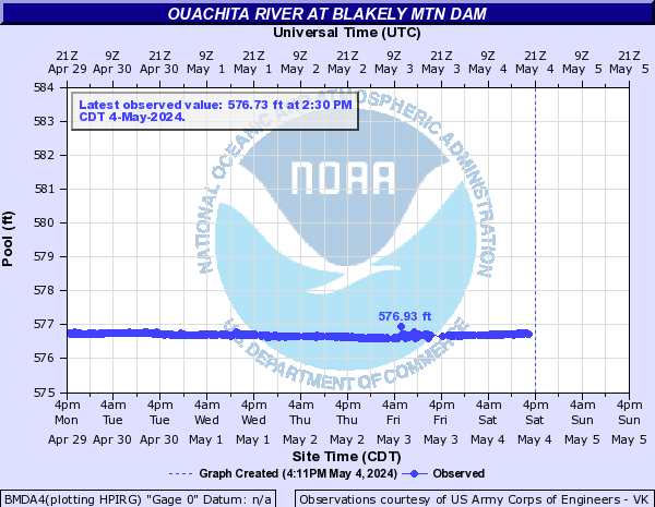
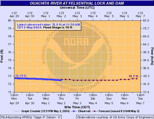
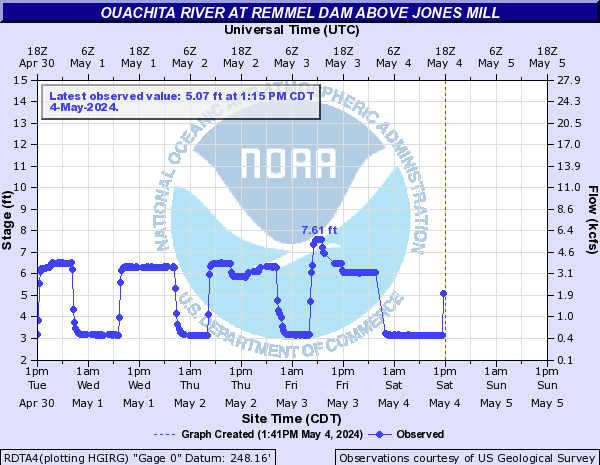
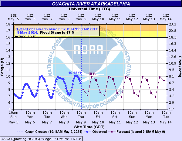
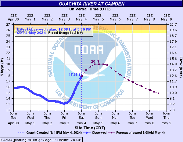
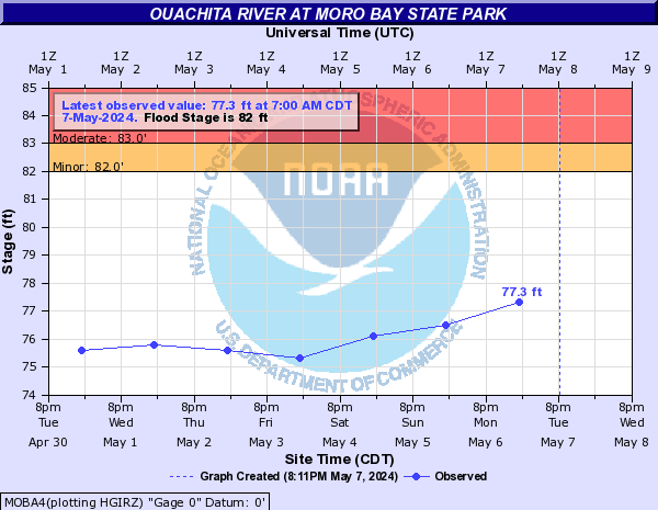
Ouachita River (Click on an image to go to hydrograph webpage)
BMDA4:
FELA4:
RDTA4:
AKDA4:
CAMA4:
CALA4:

MOBA4:
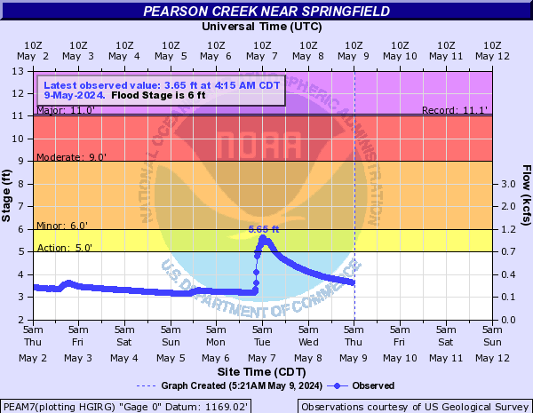
Pearson Creek (Click on an image to go to hydrograph webpage)
PEAM7:
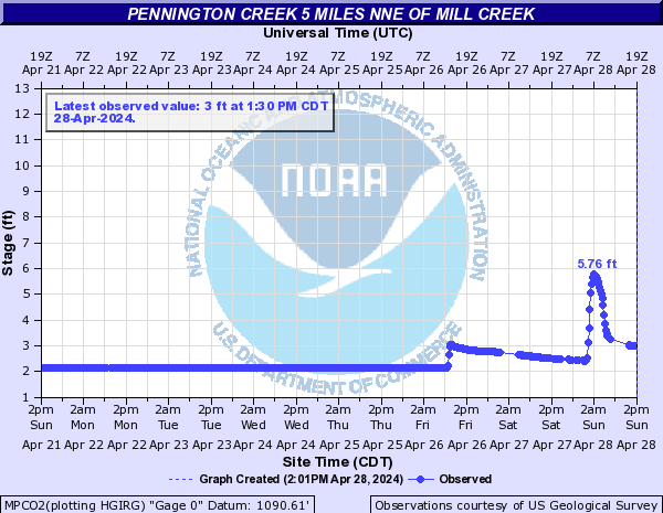
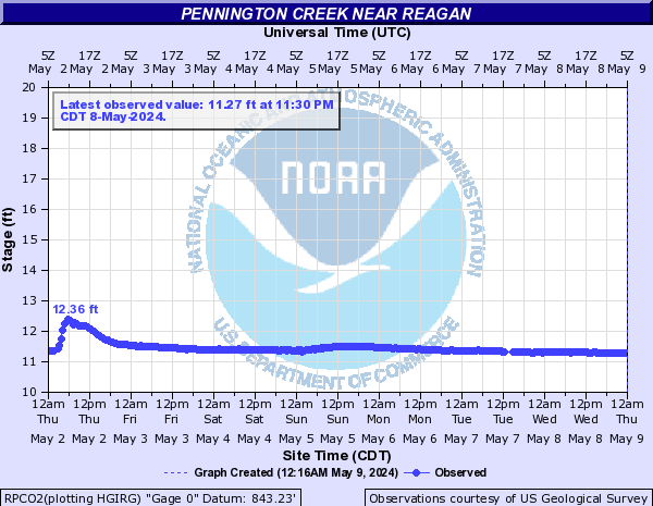
Pennington Creek (Click on an image to go to hydrograph webpage)
MPCO2:
MCPO2:

RPCO2:
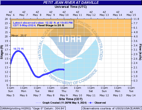
Petit Jean River (Click on an image to go to hydrograph webpage)
BMTA4:

DANA4:
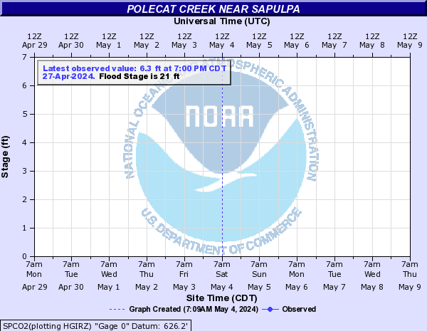
Polecat Creek (Click on an image to go to hydrograph webpage)
SPCO2:
JNKO2:

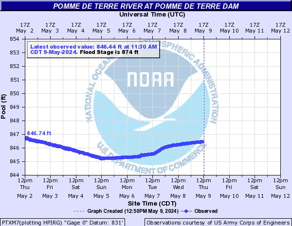
Pomme De Terre River (Click on an image to go to hydrograph webpage)
PTXM7:
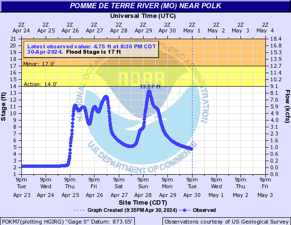
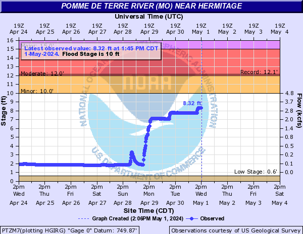
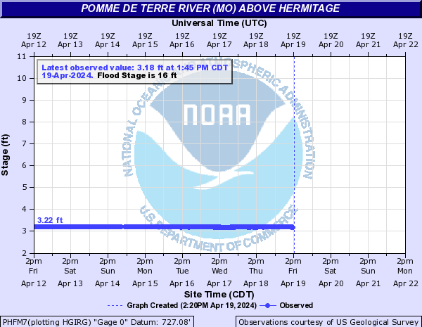
Pomme de Terre River (MO) (Click on an image to go to hydrograph webpage)
POKM7:
PTZM7:
PHFM7:
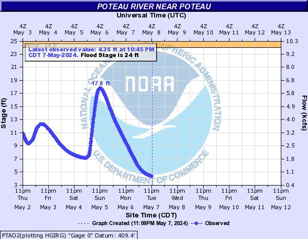
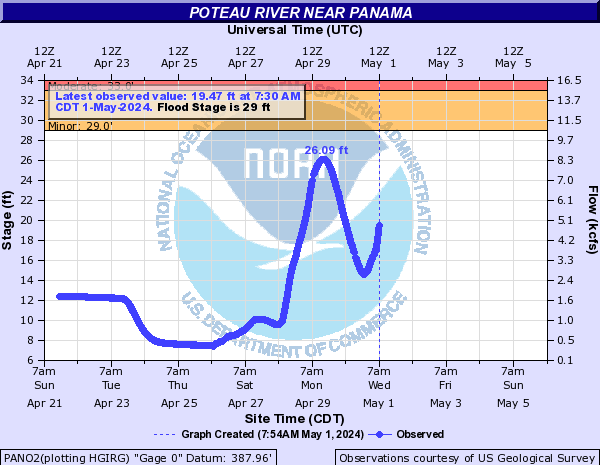
Poteau River (Click on an image to go to hydrograph webpage)
PTAO2:
PANO2:
LVNO2:

Quanah Creek (Click on an image to go to hydrograph webpage)
QPDO2:

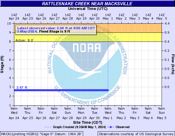
Rattlesnake Creek (KS) (Click on an image to go to hydrograph webpage)
MACK1:
ZENK1:

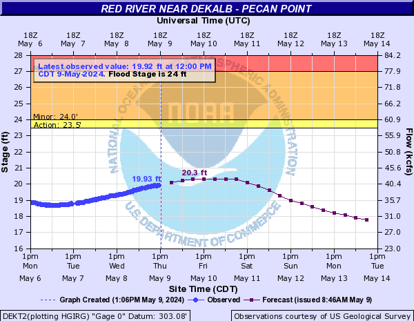
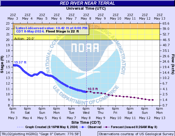
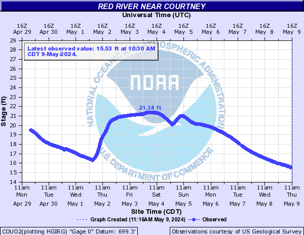
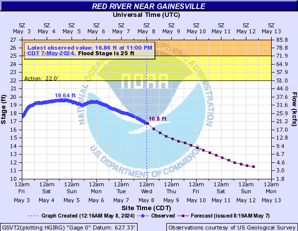
Red River (Click on an image to go to hydrograph webpage)
DVDO2:

ARCT2:

DEKT2:
INGA4:

BKBT2:

FLTA4:

TRLO2:
COUO2:
SBFA4:

GSVT2:
DSNT2:

DSTT2:

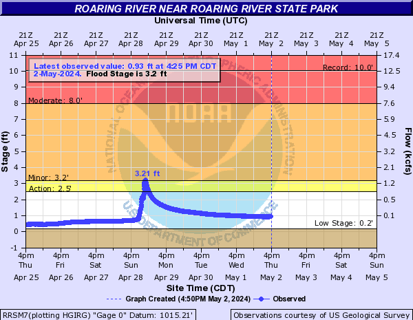
Roaring River (Click on an image to go to hydrograph webpage)
RRSM7:
Roark Creek (Click on an image to go to hydrograph webpage)
RCBM7:
Rock Creek (OK) (Click on an image to go to hydrograph webpage)
SRCO2:
ARBO2:
Rolling Fork (Click on an image to go to hydrograph webpage)
DQNA4:
Roubidoux Creek (Click on an image to go to hydrograph webpage)
RBUM7:

RBXM7:

Rowlette Creek (Click on an image to go to hydrograph webpage)
SHCT2:

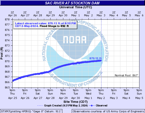
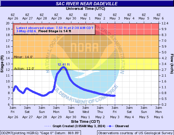
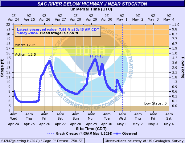
Sac River (Click on an image to go to hydrograph webpage)
CMZM7:

STXM7:
DDZM7:
SJZM7:
STZM7:

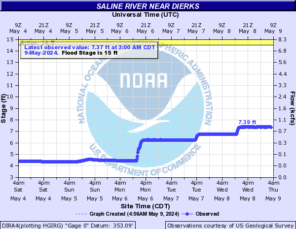
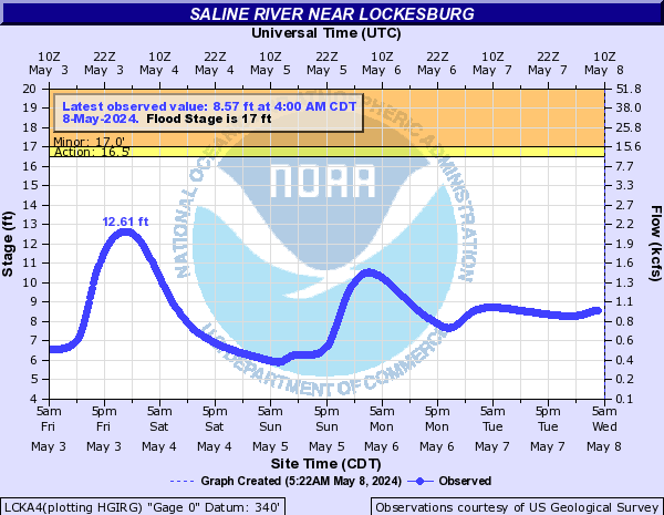
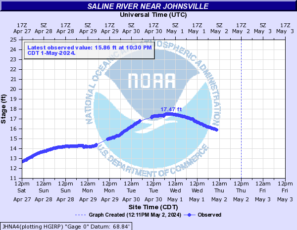
Saline River (Click on an image to go to hydrograph webpage)
DIRA4:
BTNA4:

LCKA4:
RYEA4:

WARA4:

JHNA4:
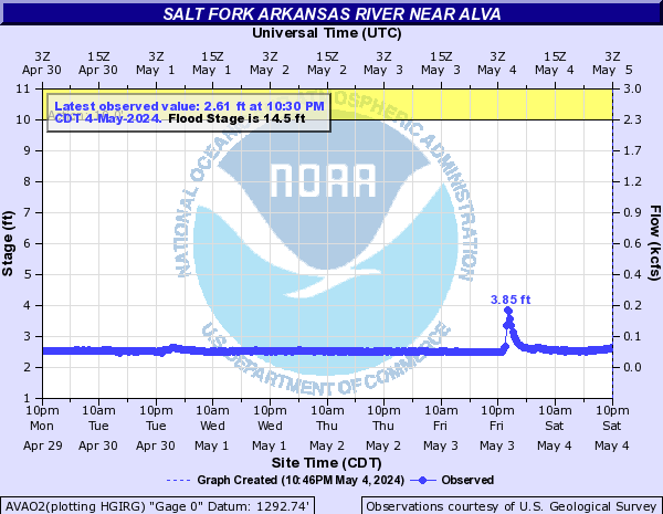
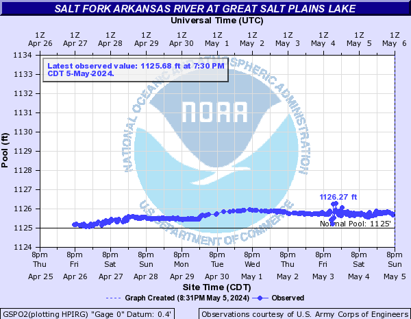
Salt Fork Arkansas River (Click on an image to go to hydrograph webpage)
AVAO2:
GSPO2:
TONO2:

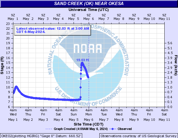
Sand Creek (OK) (Click on an image to go to hydrograph webpage)
OKEO2:
Shoal Creek (MO) (Click on an image to go to hydrograph webpage)
JOPM7:

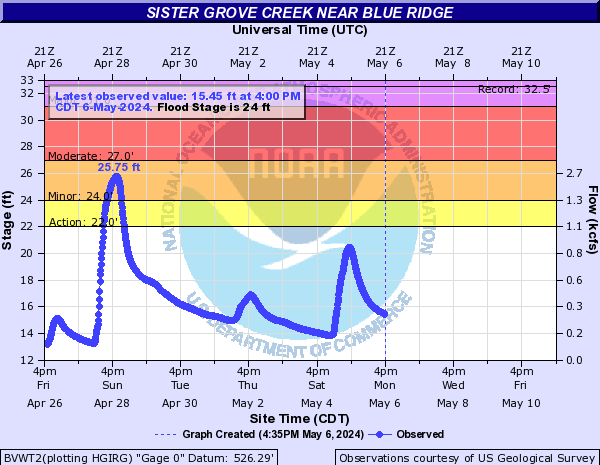
Sister Grove Creek (Click on an image to go to hydrograph webpage)
BVWT2:
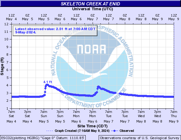
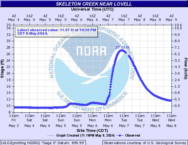
Skeleton Creek (Click on an image to go to hydrograph webpage)
ESCO2:
LVLO2:
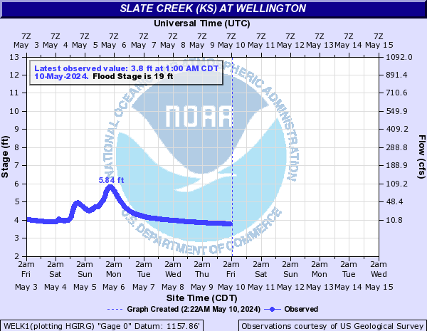
Slate Creek (KS) (Click on an image to go to hydrograph webpage)
WELK1:
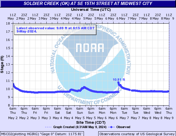
Soldier Creek (OK) (Click on an image to go to hydrograph webpage)
MSCO2:
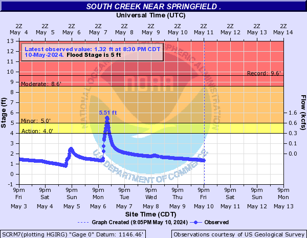
South Creek (Click on an image to go to hydrograph webpage)
SCRM7:
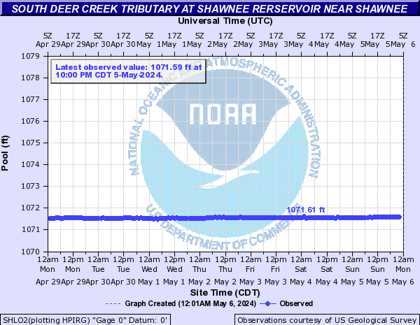
South Deer Creek Tributary (Click on an image to go to hydrograph webpage)
SHLO2:
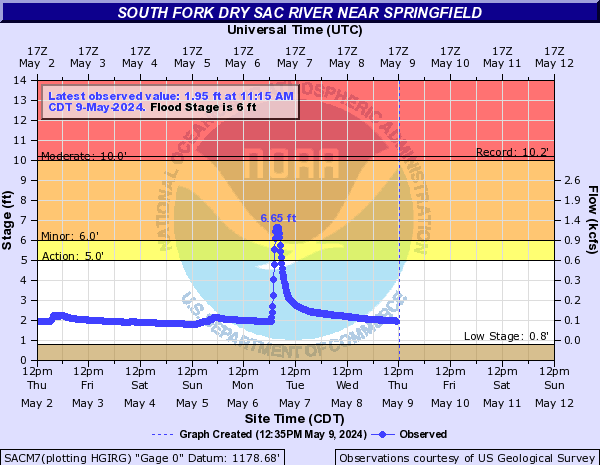
South Fork Dry Sac River (Click on an image to go to hydrograph webpage)
SACM7:
South Fork Ninnescah River (Click on an image to go to hydrograph webpage)
PTTK1:

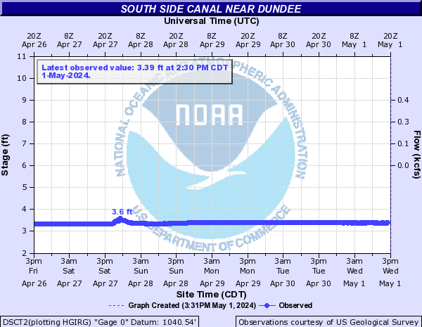
South Side Canal (Click on an image to go to hydrograph webpage)
DSCT2:
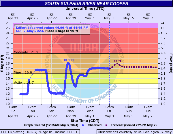
South Sulphur River (Click on an image to go to hydrograph webpage)
COPT2:
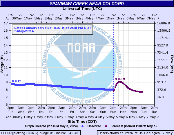
Spavinaw Creek (Click on an image to go to hydrograph webpage)
CCDO2:
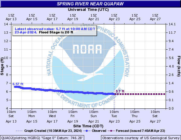
Spring River (Click on an image to go to hydrograph webpage)
QUAO2:
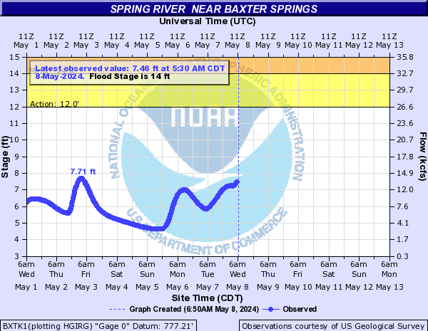
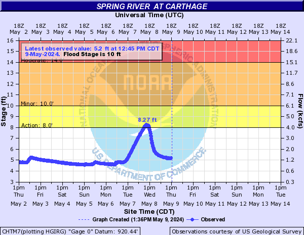
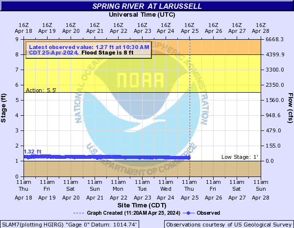
Spring River (Click on an image to go to hydrograph webpage)
BXTK1:
CHTM7:
SLAM7:
WCOM7:

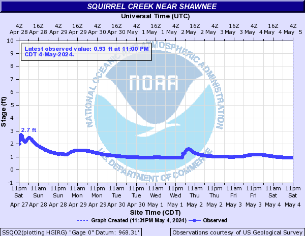
Squirrel Creek (Click on an image to go to hydrograph webpage)
SSQO2:
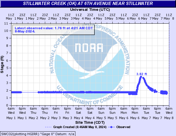
Stillwater Creek (OK) (Click on an image to go to hydrograph webpage)
SWCO2:
SFRO2:

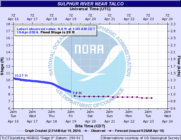
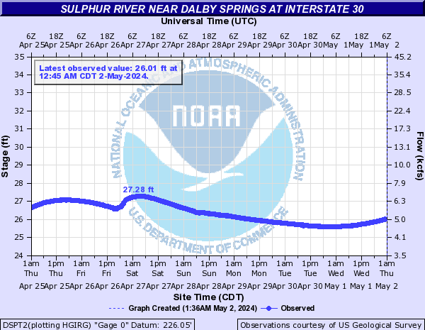
Sulphur River (Click on an image to go to hydrograph webpage)
TLCT2:
DSPT2:
Travertine Creek (Click on an image to go to hydrograph webpage)
STCO2:

Turkey Creek (MO) (Click on an image to go to hydrograph webpage)
TCKM7:

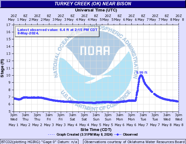
Turkey Creek (OK) (Click on an image to go to hydrograph webpage)
BTCO2:
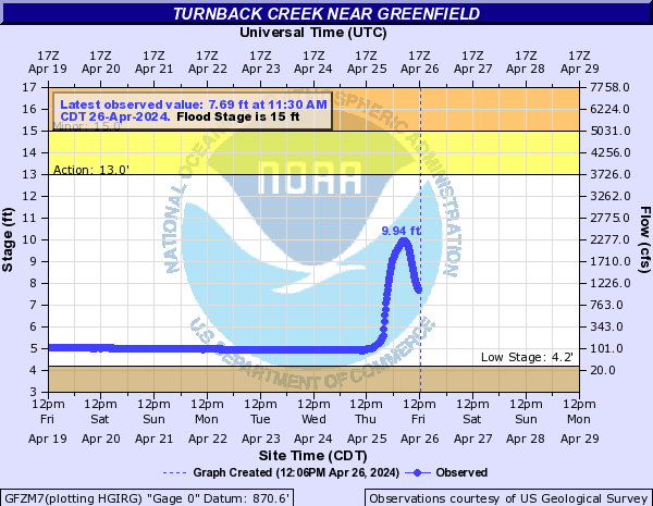
Turnback Creek (Click on an image to go to hydrograph webpage)
GFZM7:
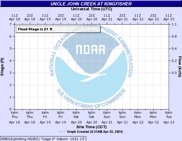
Uncle John Creek (Click on an image to go to hydrograph webpage)
KNRO2:
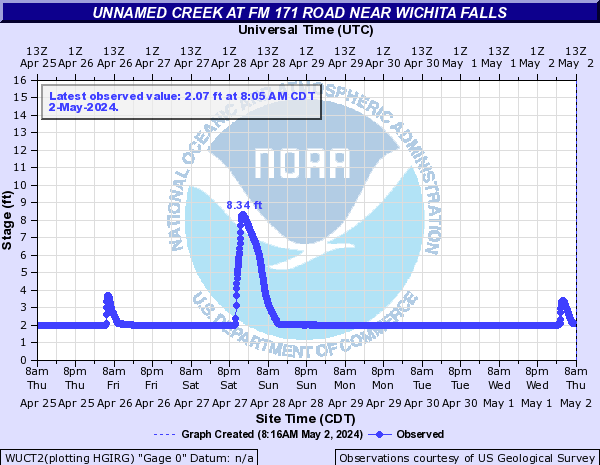
Unnamed Creek (Click on an image to go to hydrograph webpage)
WUCT2:
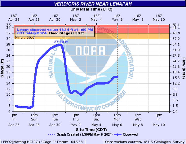
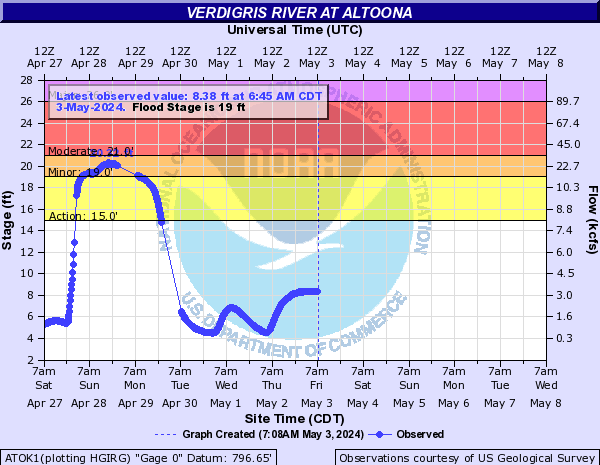
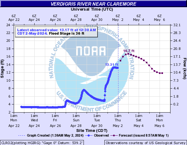
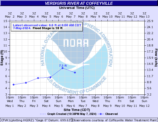
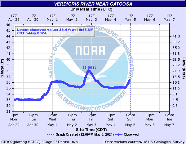
Verdigris River (Click on an image to go to hydrograph webpage)
LEPO2:
ATOK1:
IDPK1:

CLRO2:
CFVK1:
CTOO2:
TRLK1:

INOO2:

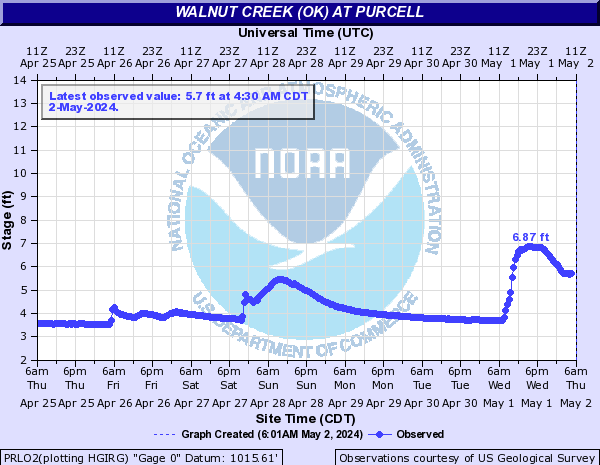
Walnut Creek (OK) (Click on an image to go to hydrograph webpage)
PRLO2:
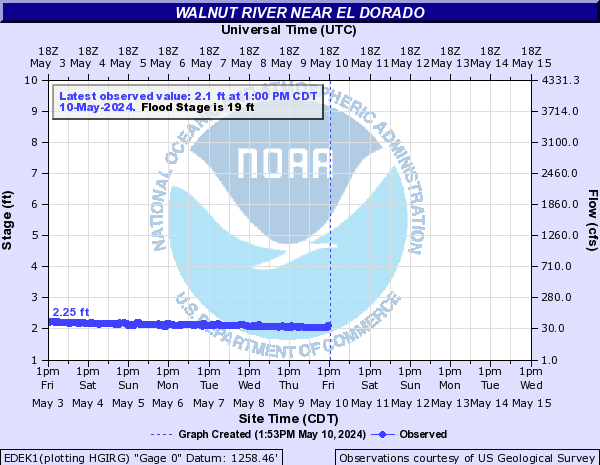
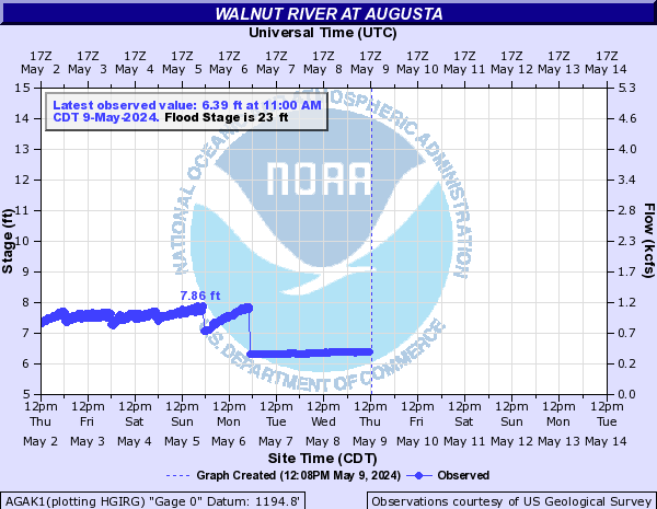
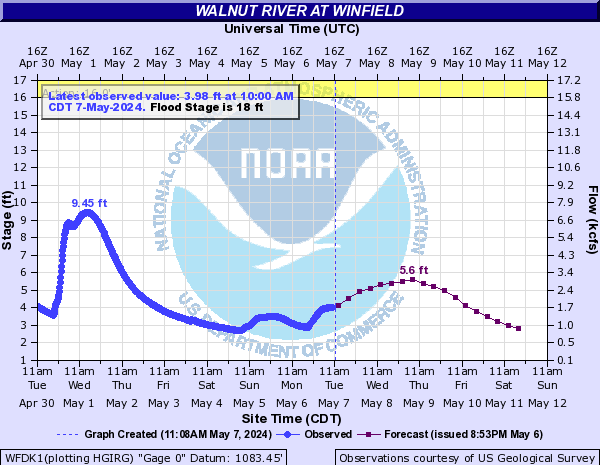
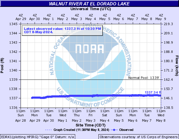
Walnut River (Click on an image to go to hydrograph webpage)
EDEK1:
AGAK1:
WFDK1:
ARKK1:

EDRK1:
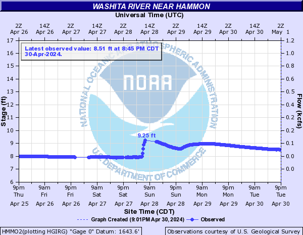
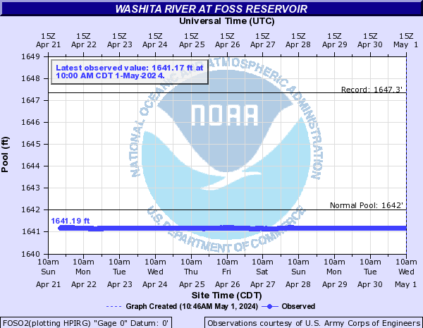
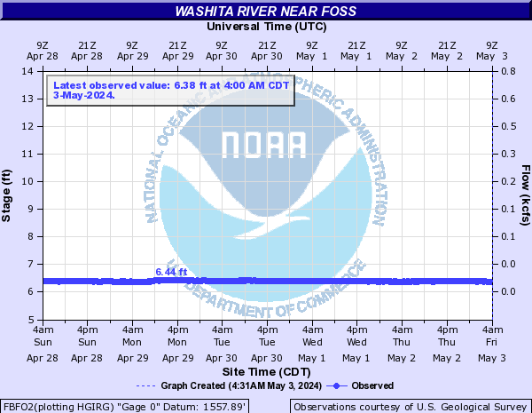
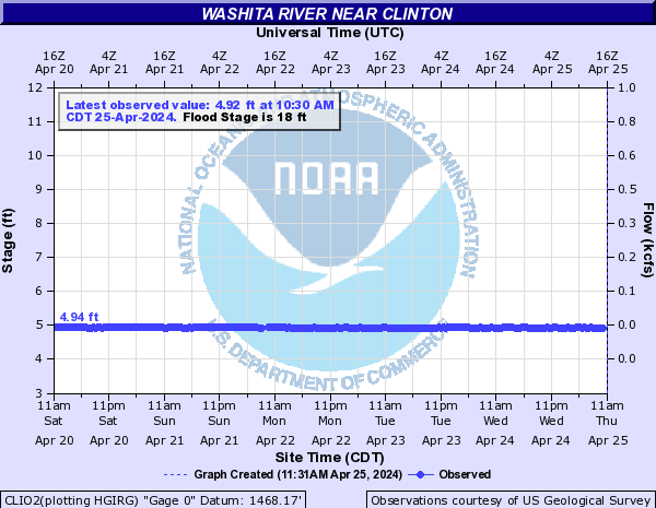
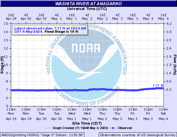
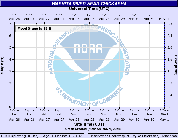
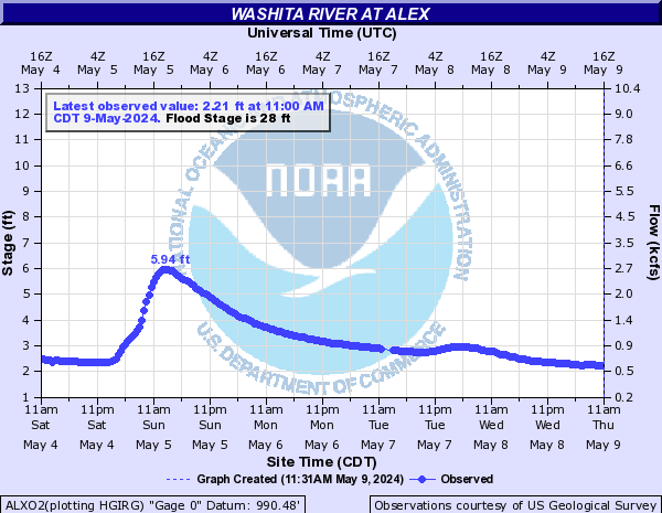
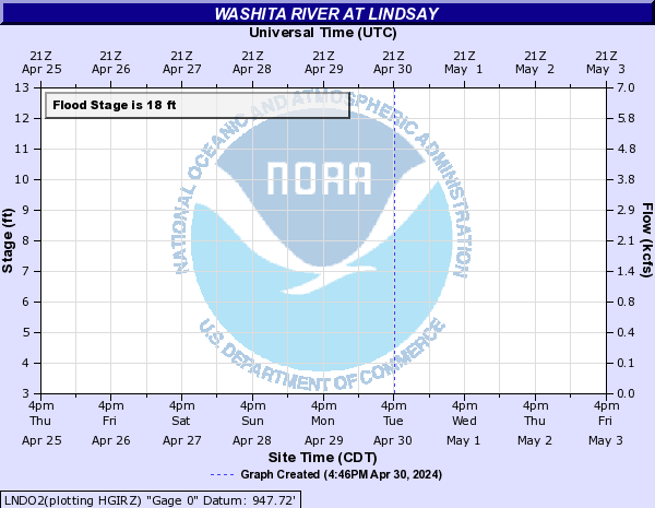
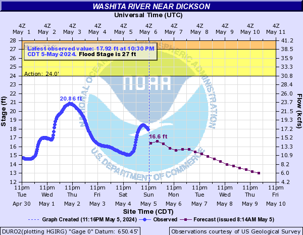
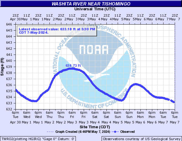
Washita River (Click on an image to go to hydrograph webpage)
HMMO2:
FOSO2:
FBFO2:
CLIO2:
CCWO2:

CAGO2:

ANDO2:
CCKO2:
ALXO2:
LNDO2:
PLVO2:

DURO2:
TWRO2:
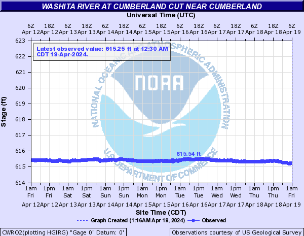
CWRO2:
Weaubleau Creek (Click on an image to go to hydrograph webpage)
WBLM7:
West Branch Walnut River (Click on an image to go to hydrograph webpage)
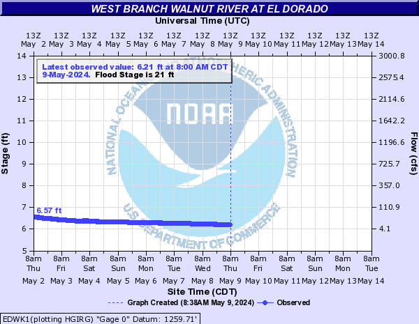
EDWK1:
West Fork Trinity River (Click on an image to go to hydrograph webpage)
JAKT2:

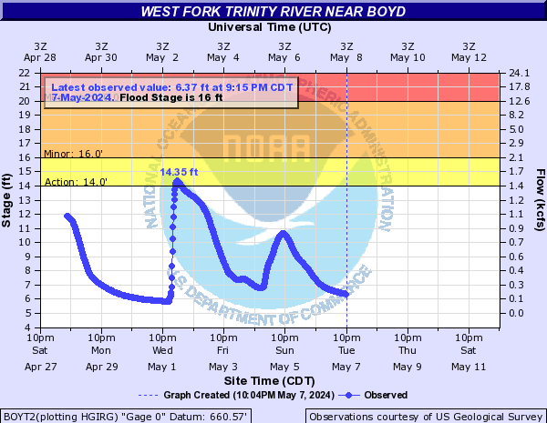
BOYT2:
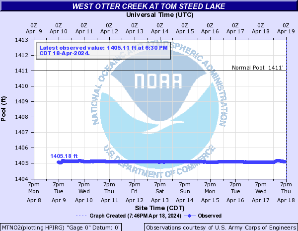
West Otter Creek (Click on an image to go to hydrograph webpage)
MTNO2:
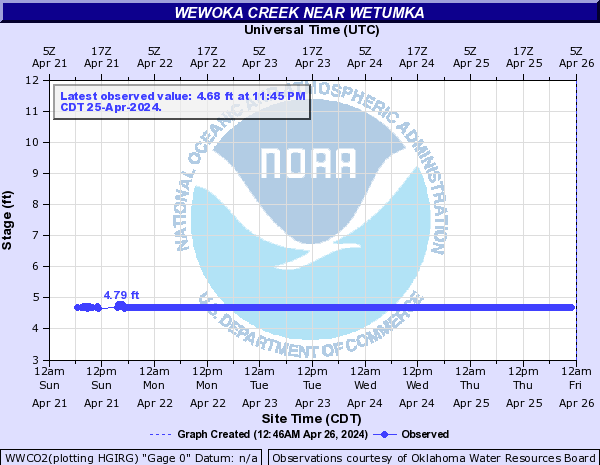
Wewoka Creek (Click on an image to go to hydrograph webpage)
WWCO2:
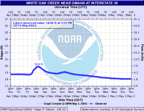
White Oak Creek (Click on an image to go to hydrograph webpage)
WOCT2:

OMWT2:
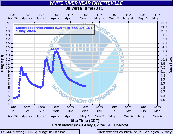
White River (Click on an image to go to hydrograph webpage)
CLRA4:

FYGA4:
ALLA4:

BAGA4:

BSGA4:

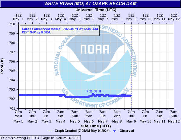
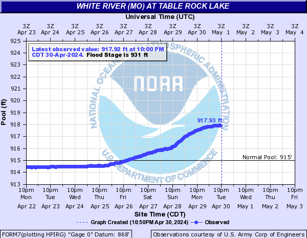
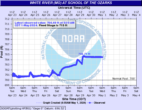
White River (MO) (Click on an image to go to hydrograph webpage)
PSZM7:
FORM7:
SOGM7:
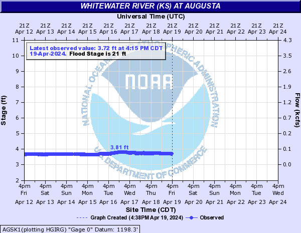
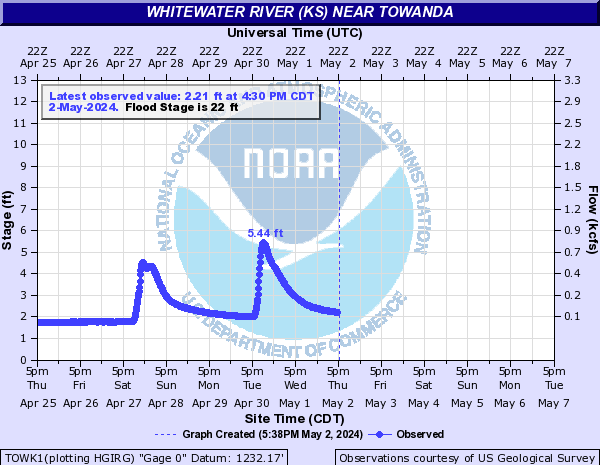
Whitewater River (KS) (Click on an image to go to hydrograph webpage)
AGSK1:
TOWK1:
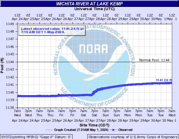
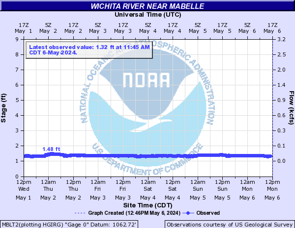
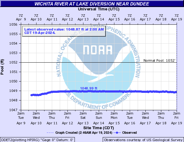
Wichita River (Click on an image to go to hydrograph webpage)
SYOT2:
MBLT2:
DDET2:
IPWT2:
WICT2:
WFRT2:
CHWT2:

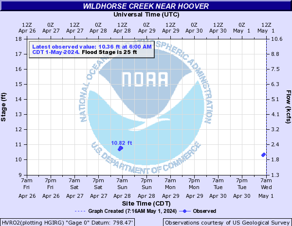
Wildhorse Creek (Click on an image to go to hydrograph webpage)
LHUO2:
HVRO2:
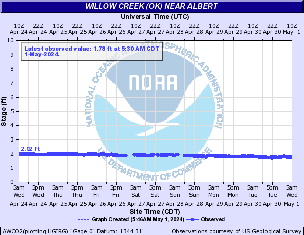
Willow Creek (OK) (Click on an image to go to hydrograph webpage)
AWCO2:
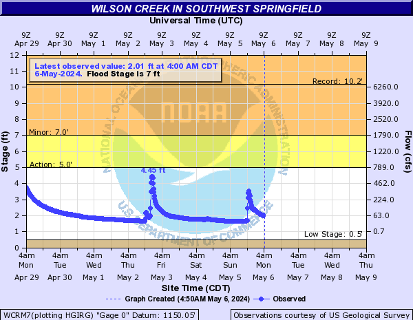
Wilson Creek (Click on an image to go to hydrograph webpage)
WCCM7:

WCRM7:
WCMM7:


