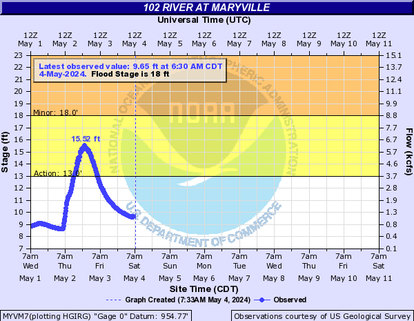
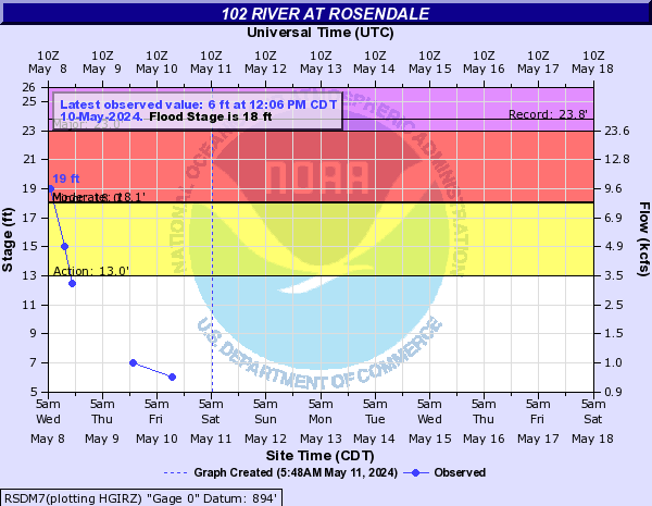
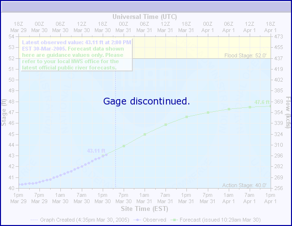
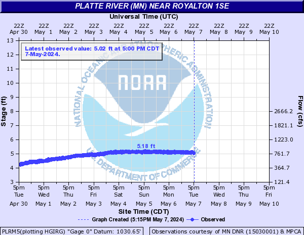
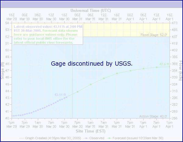
102 River (Click on an image to go to hydrograph webpage)
MYVM7:
RSDM7:
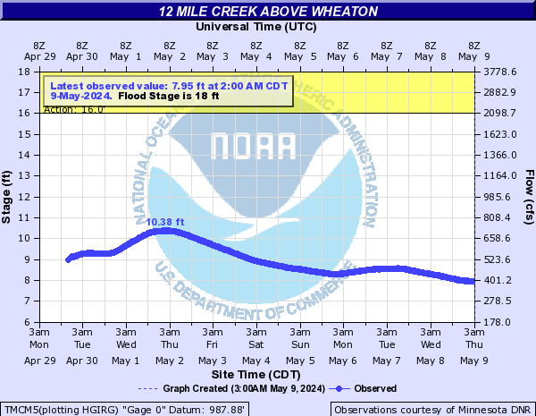
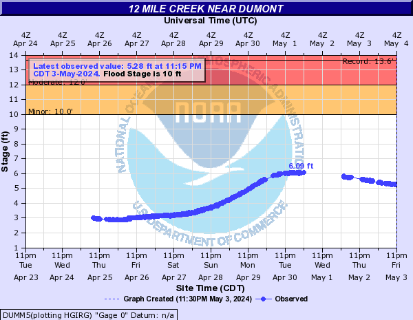
12 Mile Creek (Click on an image to go to hydrograph webpage)
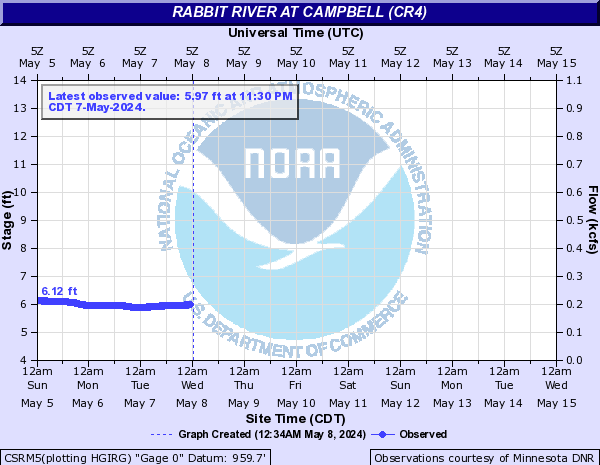
TMCM5:
DMTM5:

DUMM5:
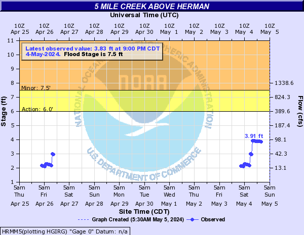
5 Mile Creek (Click on an image to go to hydrograph webpage)
HRMM5:
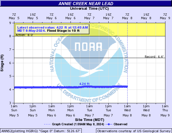
Annie Creek (Click on an image to go to hydrograph webpage)
ANNS2:
Antelope Creek (Click on an image to go to hydrograph webpage)
LATN1:

LNCN1:
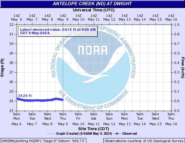
Antelope Creek (ND) (Click on an image to go to hydrograph webpage)
DWGN8:
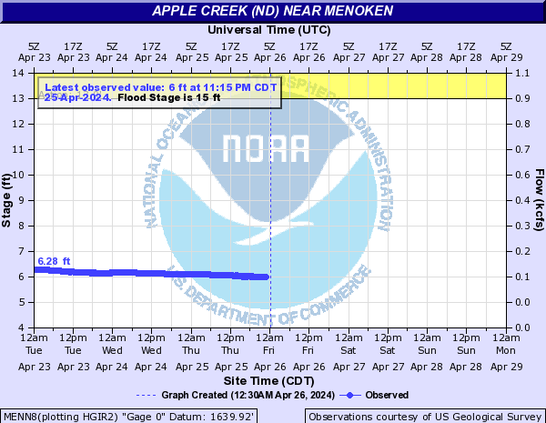
Apple Creek (ND) (Click on an image to go to hydrograph webpage)
MENN8:
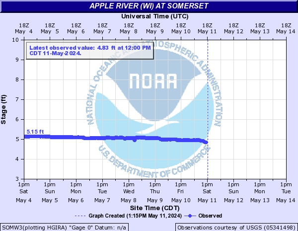
Apple River (WI) (Click on an image to go to hydrograph webpage)
SOMW3:
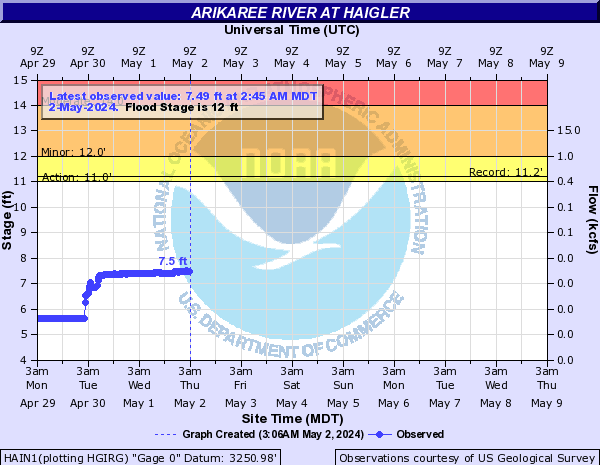
Arikaree River (Click on an image to go to hydrograph webpage)
HAIN1:
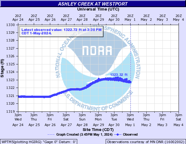
Ashley Creek (Click on an image to go to hydrograph webpage)
WPTM5:
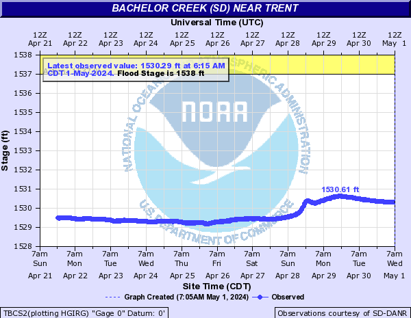
Bachelor Creek (SD) (Click on an image to go to hydrograph webpage)
TBCS2:
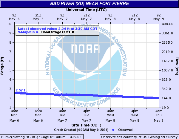
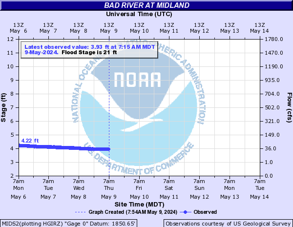
Bad River (SD) (Click on an image to go to hydrograph webpage)
FTPS2:
MIDS2:
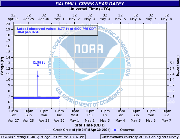
Baldhill Creek (Click on an image to go to hydrograph webpage)
DBCN8:
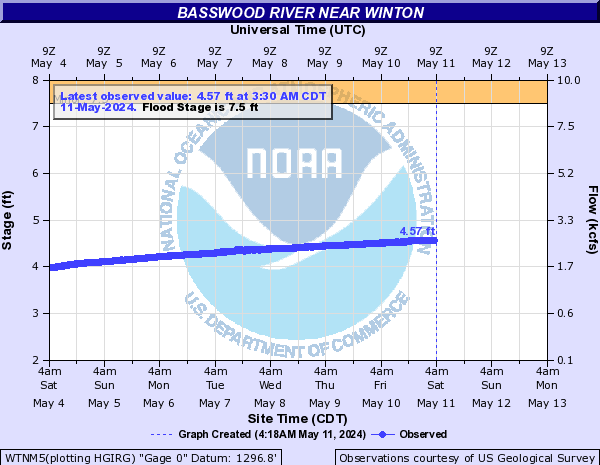
Basswood River (Click on an image to go to hydrograph webpage)
WTNM5:
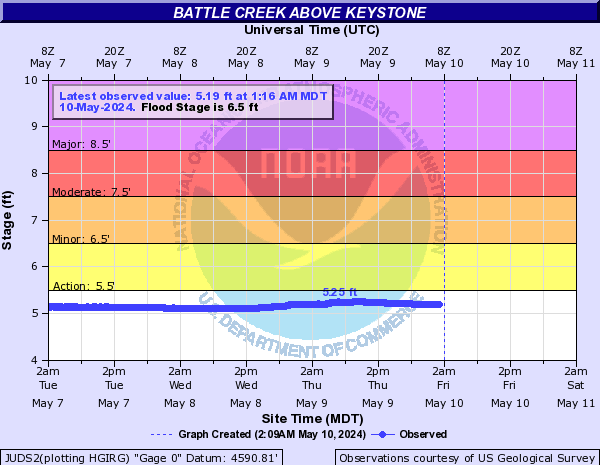
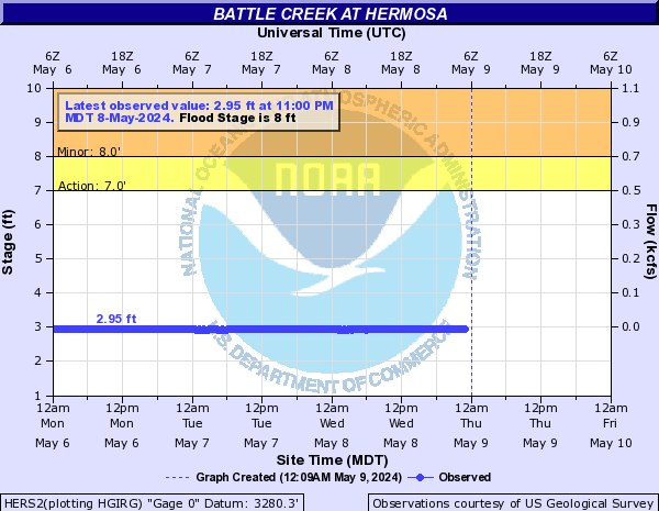
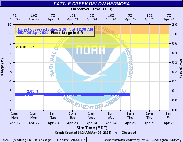
Battle Creek (SD) (Click on an image to go to hydrograph webpage)
JUDS2:
RUSS2:

HERS2:
OSAS2:
Battle River (Click on an image to go to hydrograph webpage)
SAUM5:

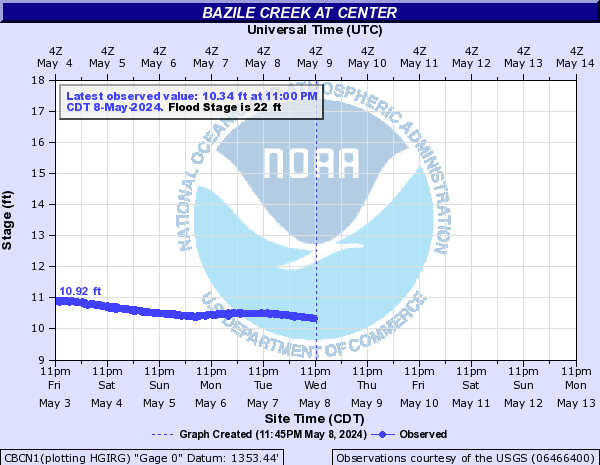
Bazile Creek (Click on an image to go to hydrograph webpage)
CBCN1:
NBZN1:

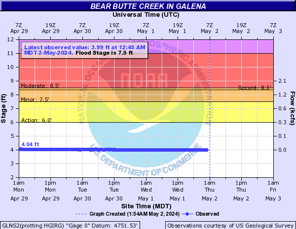
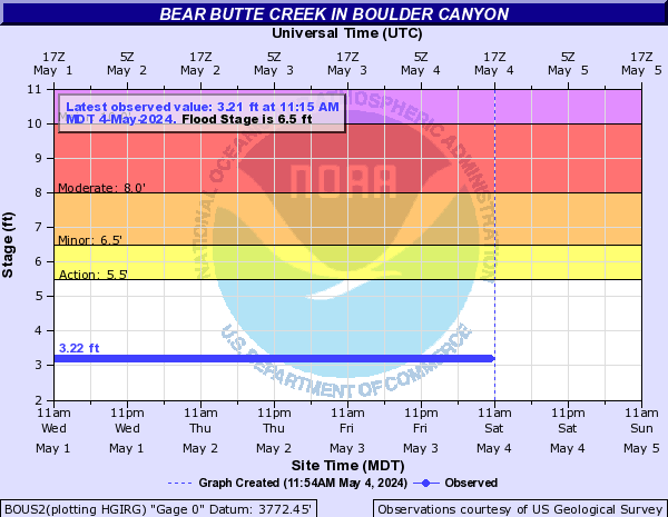
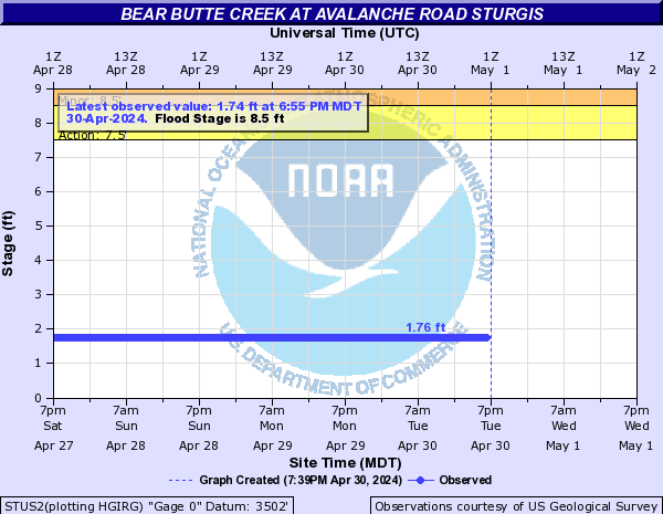
Bear Butte Creek (Click on an image to go to hydrograph webpage)
GLNS2:
BOUS2:
STUS2:
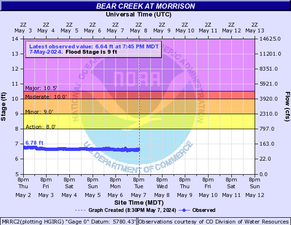
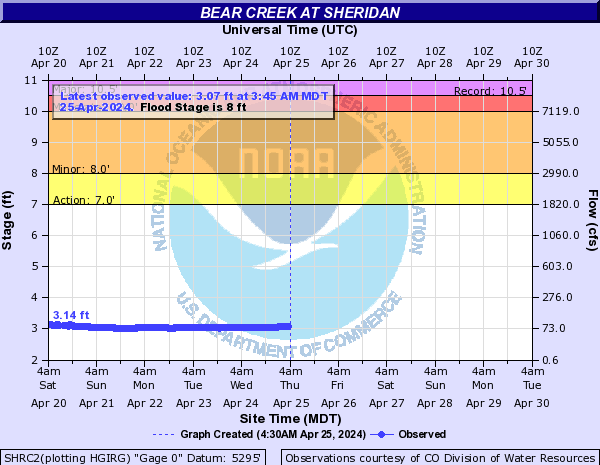
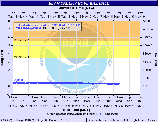
Bear Creek (CO) (Click on an image to go to hydrograph webpage)
MRRC2:
BCDC2:

SHRC2:
BBCC2:

CGCC2:
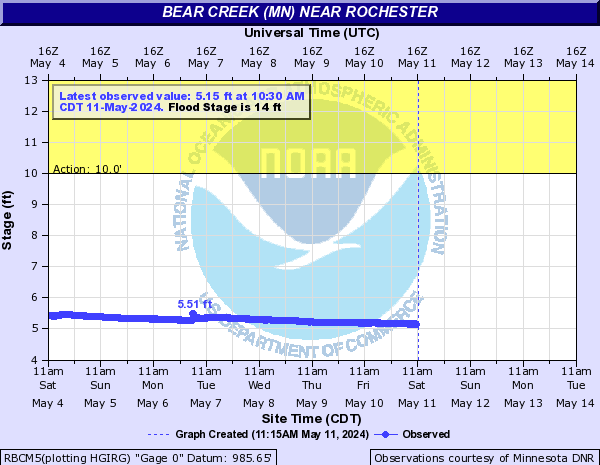
Bear Creek (MN) (Click on an image to go to hydrograph webpage)
RBCM5:
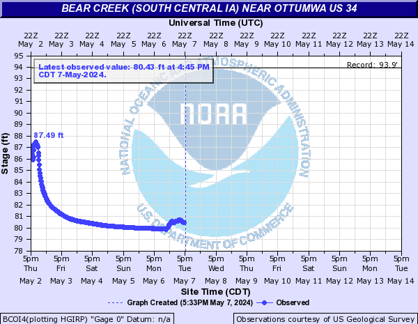
Bear Creek (South Central IA) (Click on an image to go to hydrograph webpage)
BCOI4:
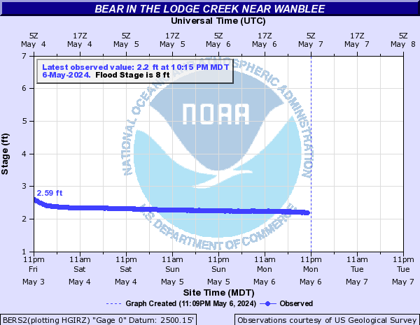
Bear in the Lodge Creek (Click on an image to go to hydrograph webpage)
BERS2:
Beaver Creek (Click on an image to go to hydrograph webpage)
LDLK1:

BEVN1:

LRTN1:

CDBK1:

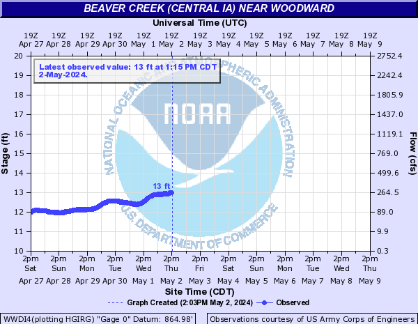
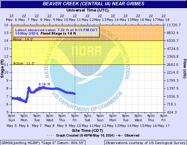
Beaver Creek (Central IA) (Click on an image to go to hydrograph webpage)
WWDI4:
GRMI4:
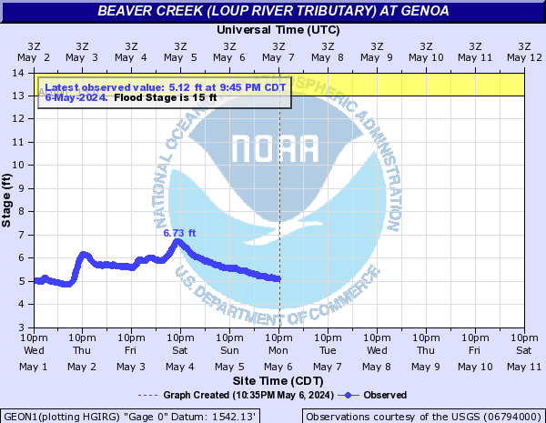
Beaver Creek (Loup River tributary) (Click on an image to go to hydrograph webpage)
GEON1:
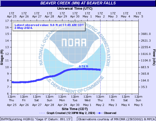
Beaver Creek (MN) (Click on an image to go to hydrograph webpage)
BVFM5:
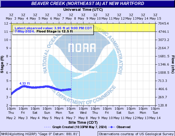
Beaver Creek (Northeast IA) (Click on an image to go to hydrograph webpage)
NHRI4:
Beaver Creek (SD) (Click on an image to go to hydrograph webpage)
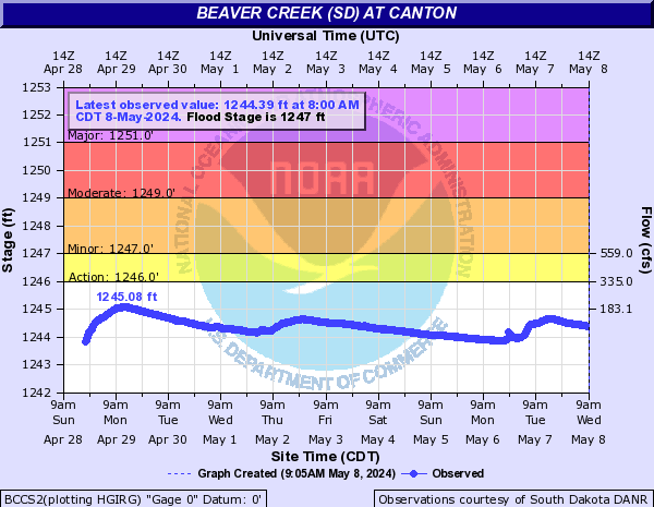
BCCS2:
PRNS2:

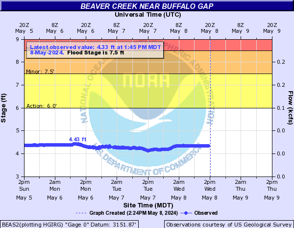
BEAS2:
Beaver Creek (South Central ND) (Click on an image to go to hydrograph webpage)
BVRN8:

Beaver Creek (SW ND) (Click on an image to go to hydrograph webpage)
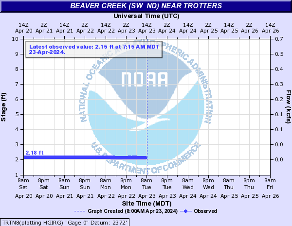
TRTN8:
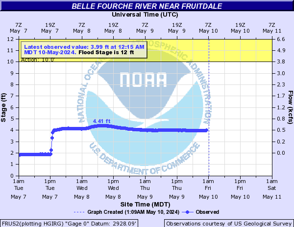
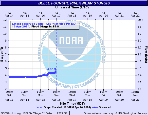
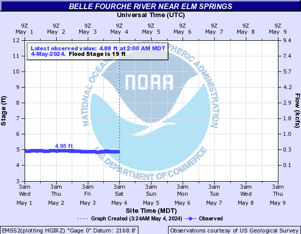
Belle Fourche River (Click on an image to go to hydrograph webpage)
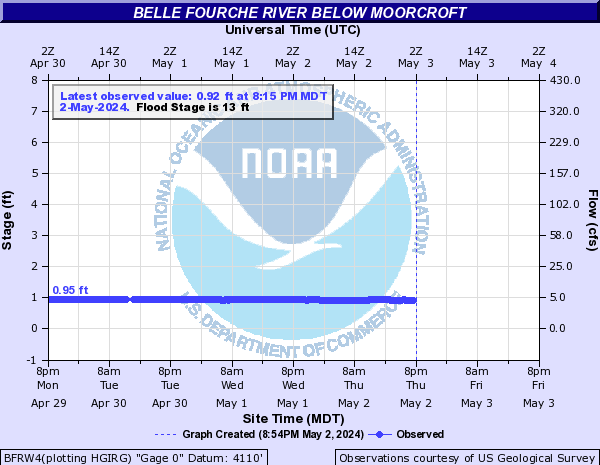
BFRW4:
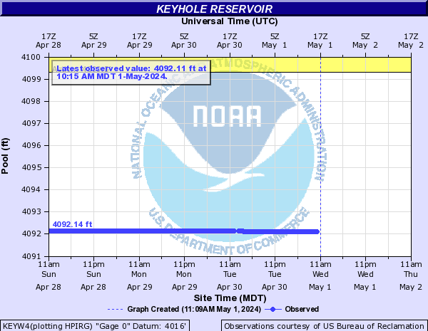
KEYW4:
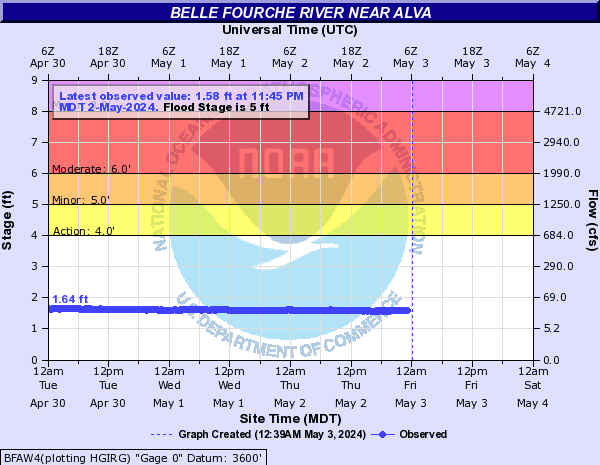
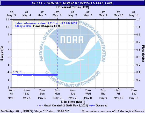
BFAW4:
BWSW4:
BLES2:

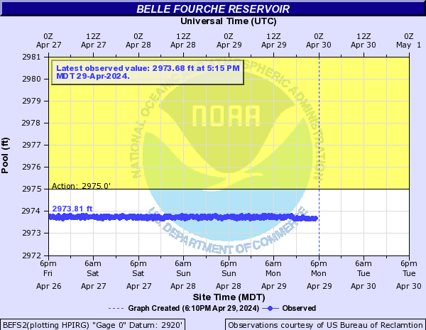
BEFS2:
FRUS2:
SBFS2:
EMSS2:
Big Bear Creek (Click on an image to go to hydrograph webpage)
LADI4:

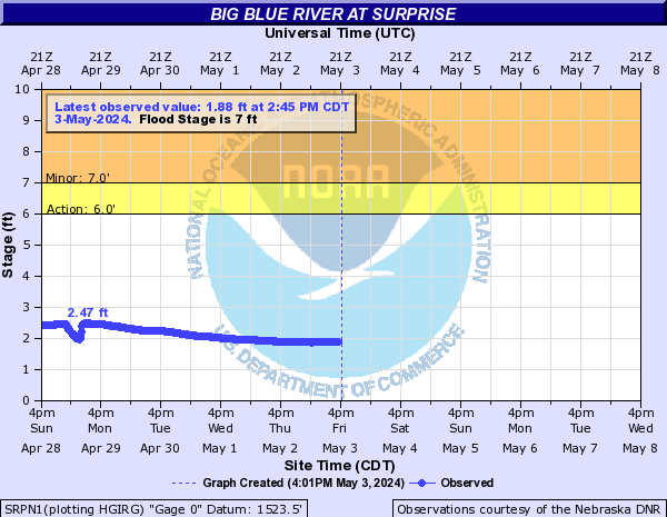
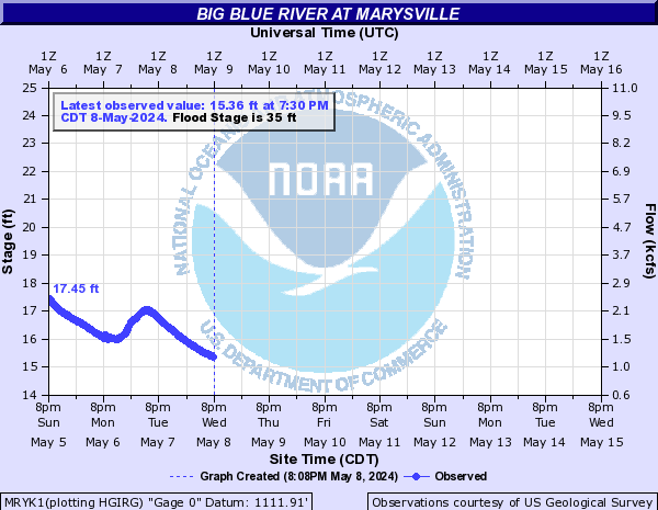
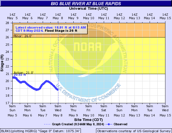
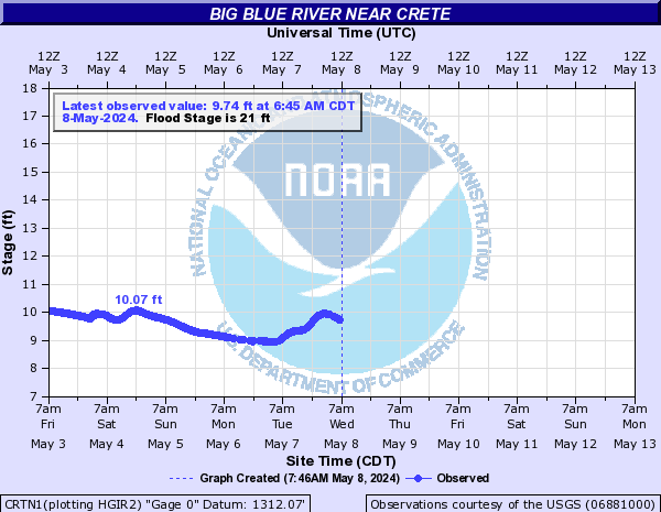
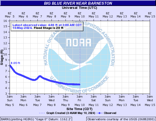
Big Blue River (Click on an image to go to hydrograph webpage)
SRPN1:
MRYK1:
BLRK1:
SWRN1:

CRTN1:
BEAN1:

BARN1:
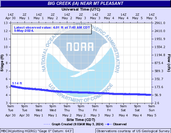
Big Creek (IA) (Click on an image to go to hydrograph webpage)
MBCI4:
Big Creek Lake (Central IA) (Click on an image to go to hydrograph webpage)
PLKI4:

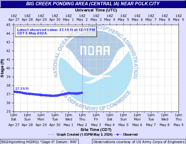
Big Creek Ponding Area (Central IA) (Click on an image to go to hydrograph webpage)
BIGI4:
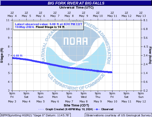
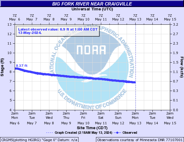
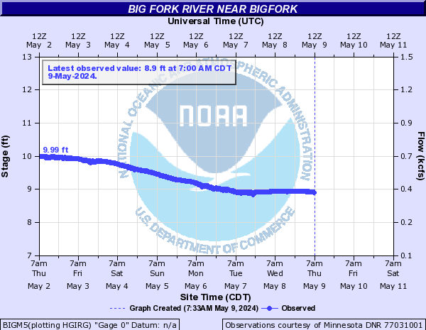
Big Fork River (Click on an image to go to hydrograph webpage)
BIFM5:
CRGM5:
BIGM5:
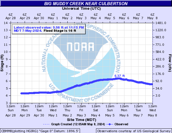
Big Muddy Creek (Click on an image to go to hydrograph webpage)
BGCM8:

CBMM8:
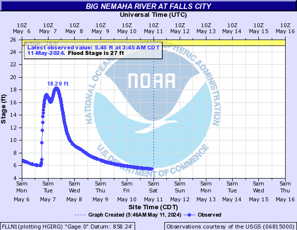
Big Nemaha River (Click on an image to go to hydrograph webpage)
FLLN1:
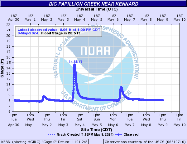
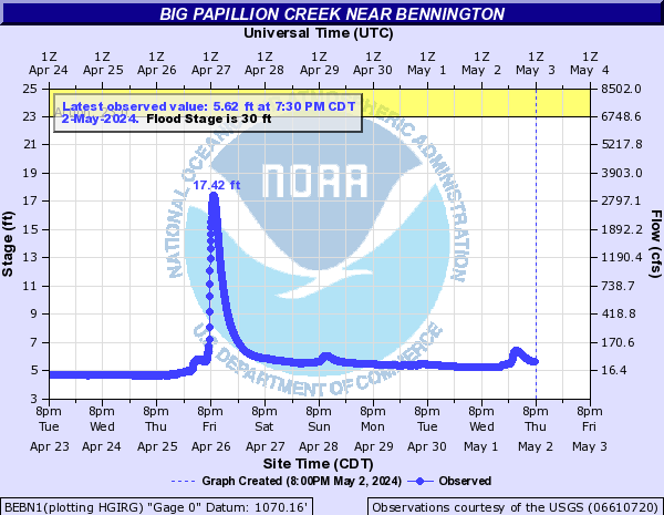
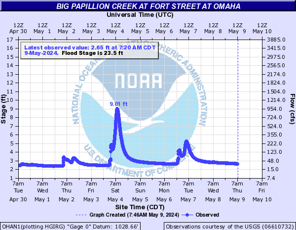
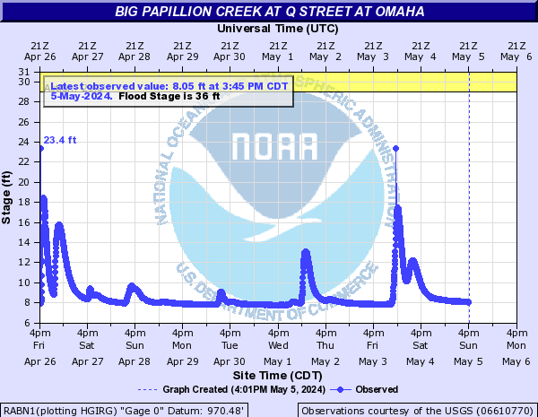
Big Papillion Creek (Click on an image to go to hydrograph webpage)
BLBN1:
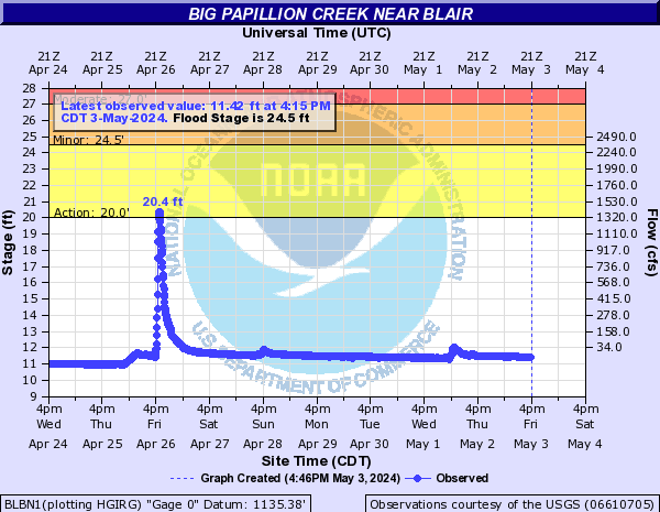
KEBN1:
BEBN1:
OHAN1:
OMBN1:
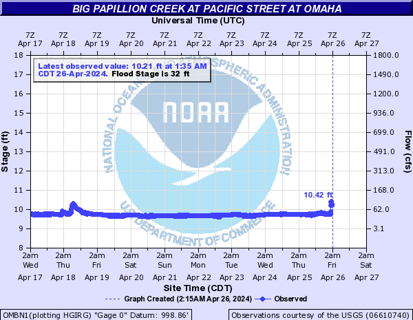
RABN1:
OMAN1:

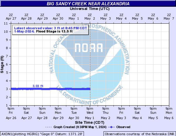
Big Sandy Creek (Click on an image to go to hydrograph webpage)
AXDN1:
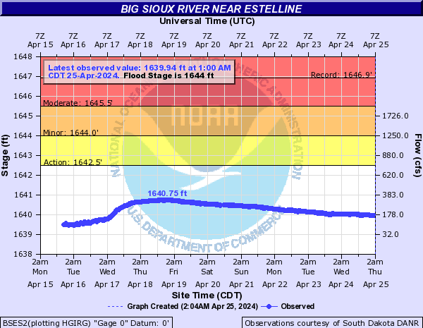
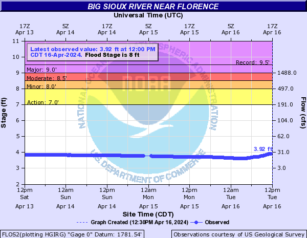
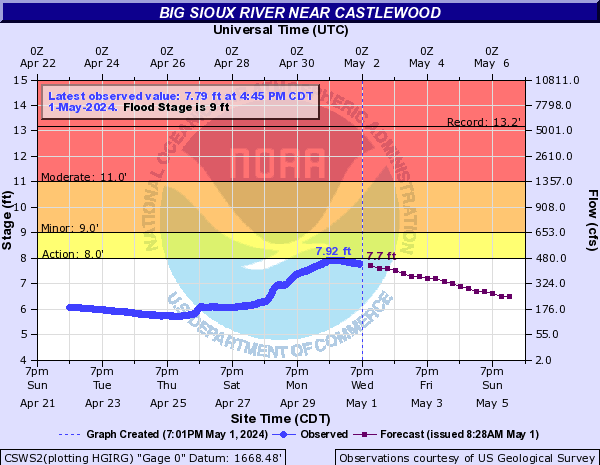
Big Sioux River (Click on an image to go to hydrograph webpage)
BSES2:
FLOS2:
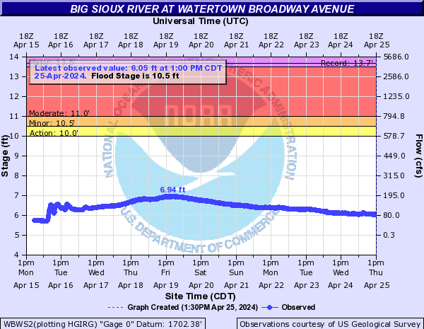
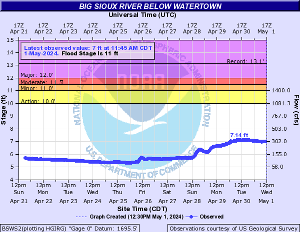
WTRS2:

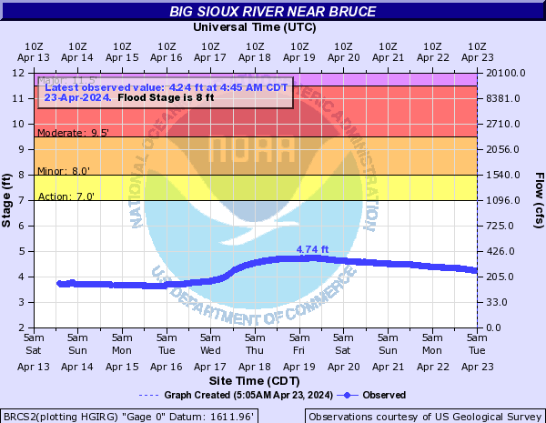
BRCS2:
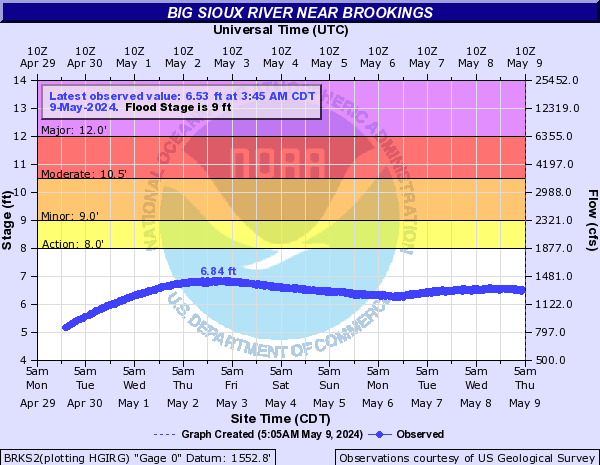
BRKS2:
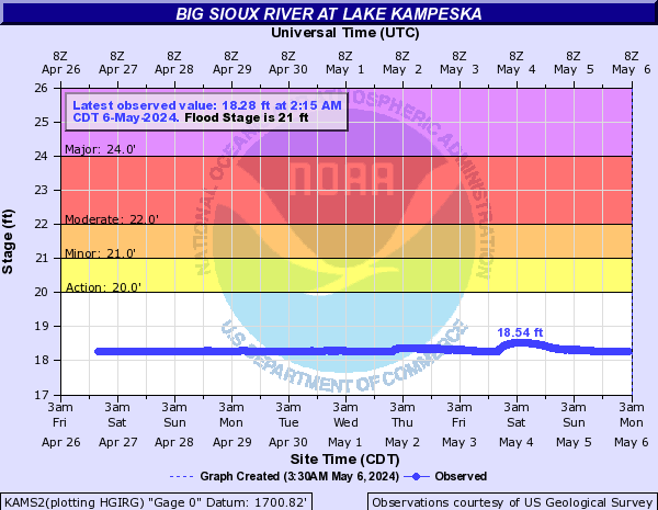
KAMS2:
WBSS2:

BSFS2:

WBWS2:
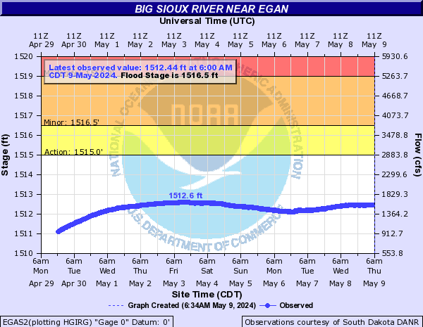
EGAS2:
BSWS2:
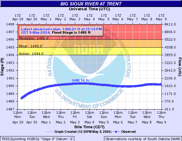
TRES2:
CSWS2:
DRBS2:

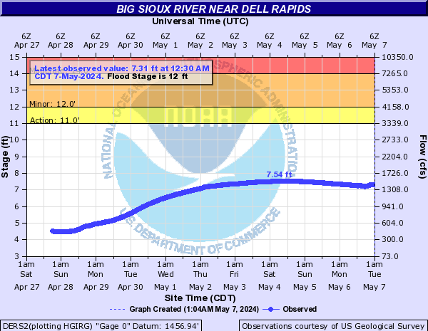
DERS2:
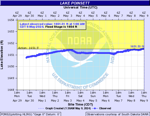
PONS2:
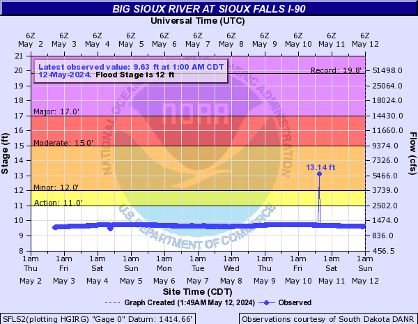
SFLS2:
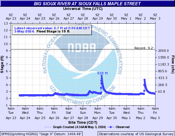
SFMS2:
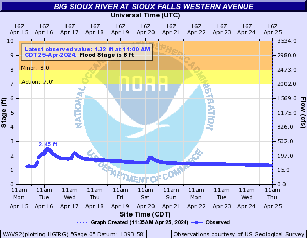
WAVS2:
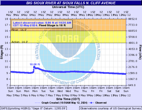
SXFS2:
BBSS2:

CBSS2:

FVWS2:

FVWS2:
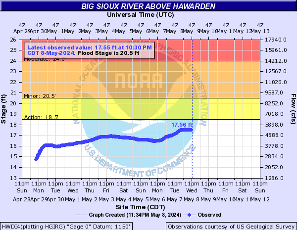
HWDI4:
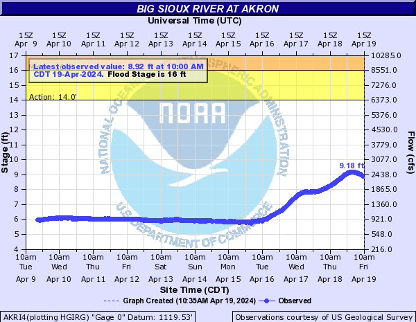
AKRI4:
BSRS2:

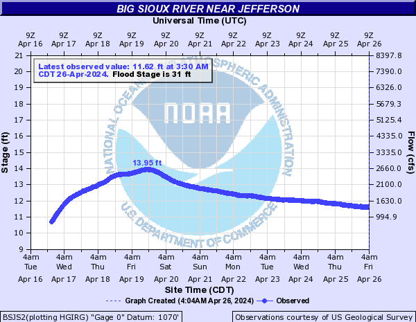
BSJS2:
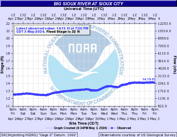
SXCI4:
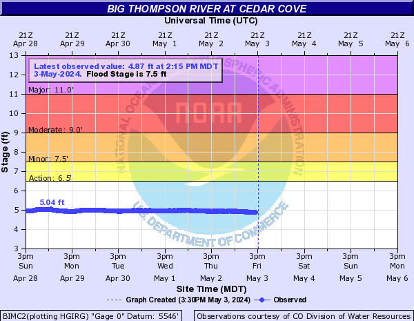
Big Thompson River (CO) (Click on an image to go to hydrograph webpage)
ESSC2:
BIMC2:
BTBC2:
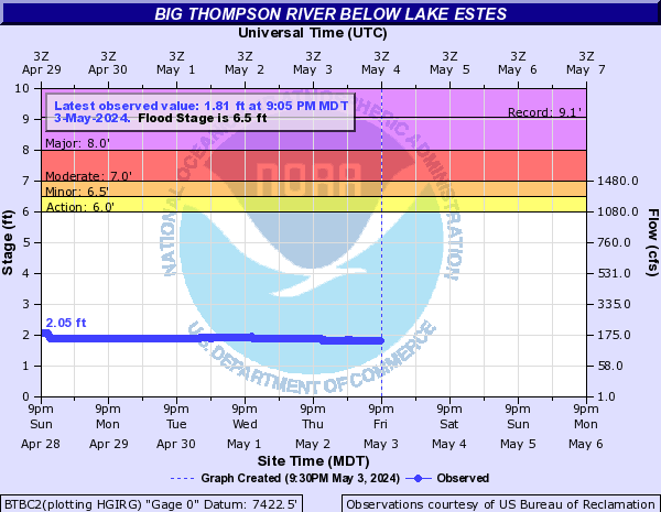
BTLC2:
LSLC2:
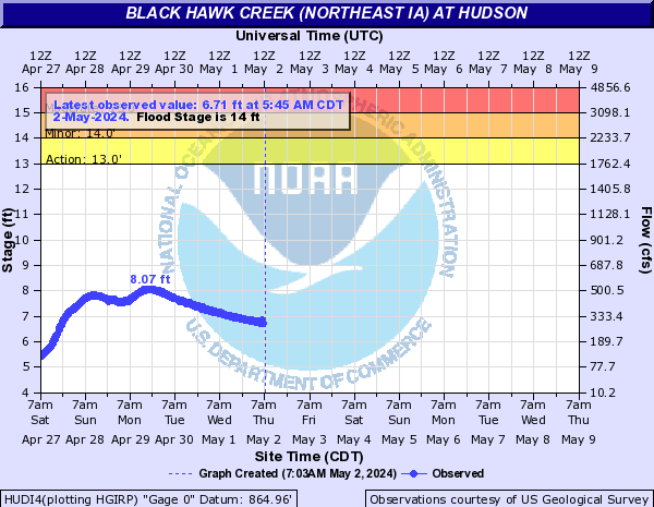
Black Hawk Creek (Northeast IA) (Click on an image to go to hydrograph webpage)
HUDI4:
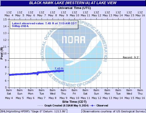
Black Hawk Lake (Western IA) (Click on an image to go to hydrograph webpage)
BHLI4:
Black Vermillion River (Click on an image to go to hydrograph webpage)
FKFK1:

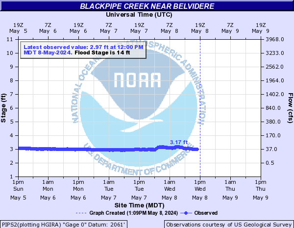
Blackpipe Creek (Click on an image to go to hydrograph webpage)
PIPS2:
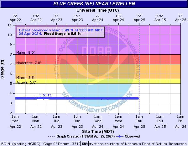
Blue Creek (NE) (Click on an image to go to hydrograph webpage)
BCLN1:
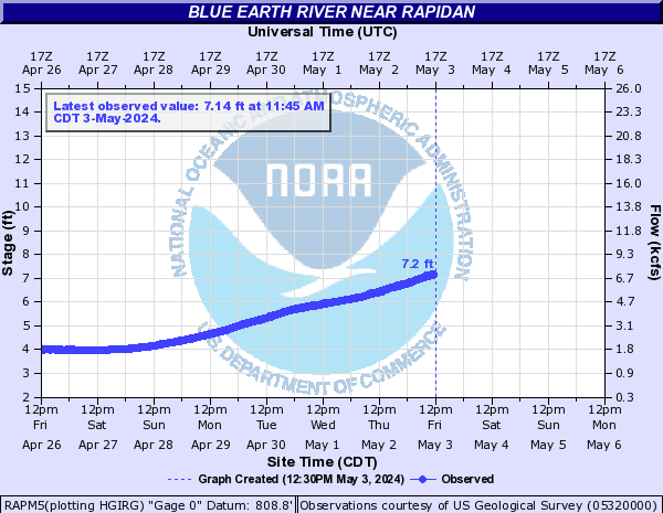
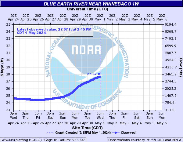
Blue Earth River (Click on an image to go to hydrograph webpage)
BEHM5:

RAPM5:
WBOM5:
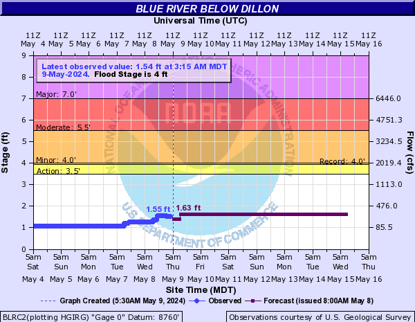
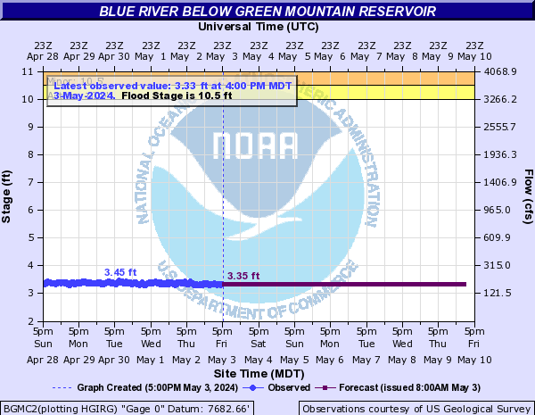
Blue River (CO) (Click on an image to go to hydrograph webpage)
BLRC2:
BGMC2:
BSWC2:
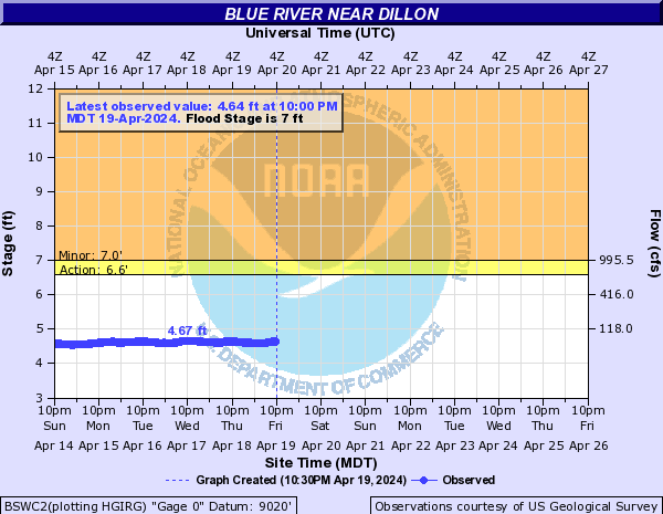
BSWC2:
GMRC2:

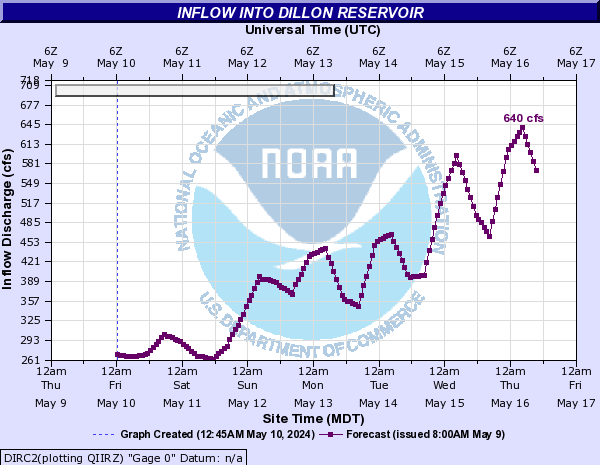
DIRC2:
Bluff Creek (Central IA) (Click on an image to go to hydrograph webpage)
PMDI4:

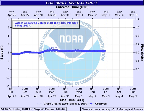
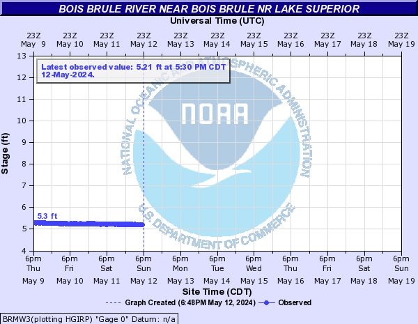
Bois Brule River (Click on an image to go to hydrograph webpage)
BRSW3:
BRMW3:
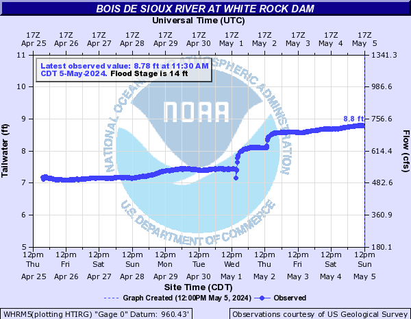
Bois de Sioux River (Click on an image to go to hydrograph webpage)
WHRM5:
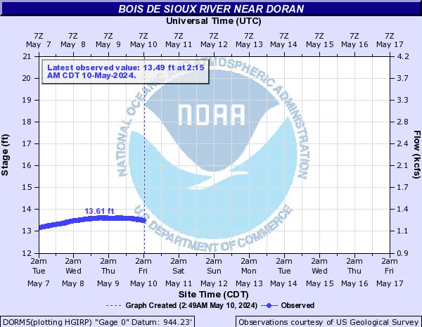
DORM5:
Boone River (North Central IA) (Click on an image to go to hydrograph webpage)
GLDI4:

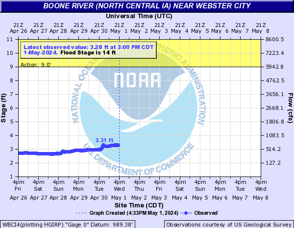
WBCI4:
Boulder Creek (CO) (Click on an image to go to hydrograph webpage)
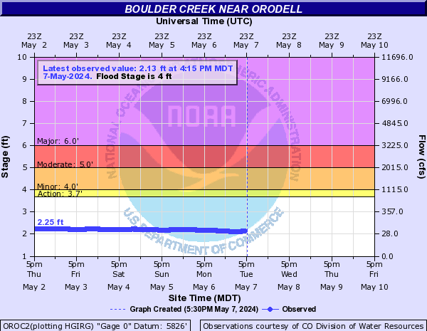
OROC2:
BOCC2:

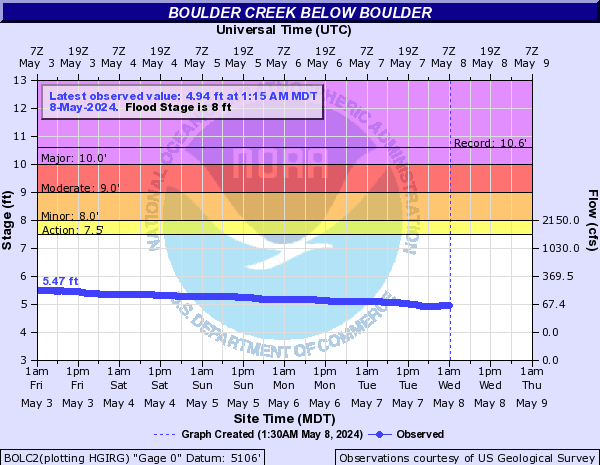
BOLC2:
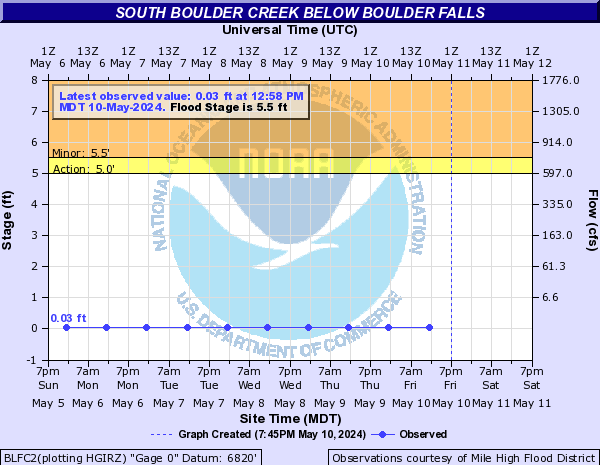
BLFC2:
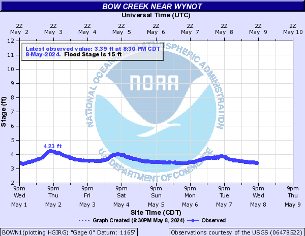
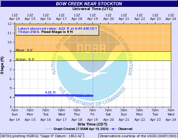
Bow Creek (Click on an image to go to hydrograph webpage)
BOWN1:
SKTK1:
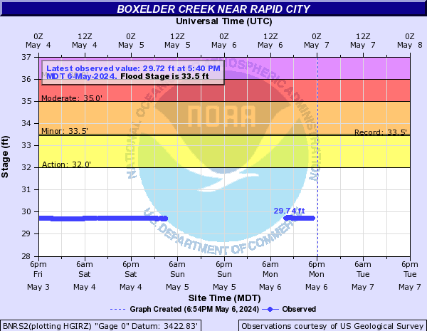
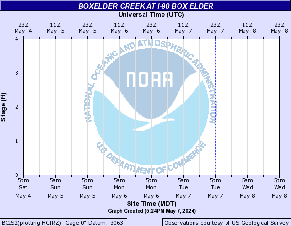
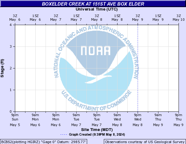
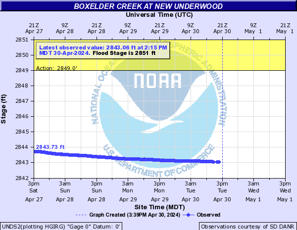
Boxelder Creek (Click on an image to go to hydrograph webpage)
BNNS2:

OAAN1:

BNRS2:
BCIS2:
BCBS2:
UNDS2:
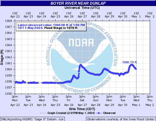
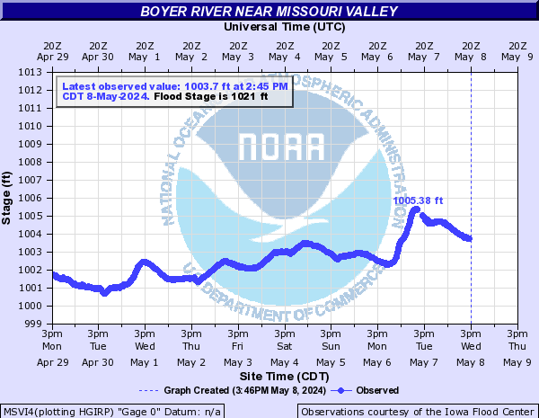
Boyer River (Click on an image to go to hydrograph webpage)
DNLI4:
LGNI4:

MSVI4:
Brockcamp Creek (Click on an image to go to hydrograph webpage)
FSTI4:

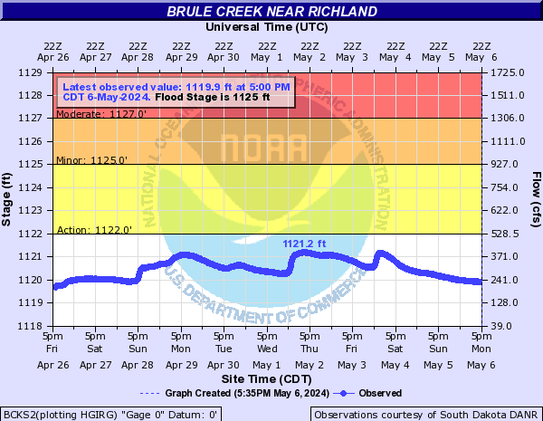
Brule Creek (Click on an image to go to hydrograph webpage)
BCKS2:
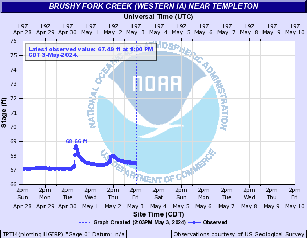
Brushy Fork Creek (Western IA) (Click on an image to go to hydrograph webpage)
TPTI4:
Buckhorn Creek (CO) (Click on an image to go to hydrograph webpage)
BKHC2:
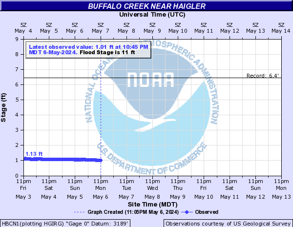
Buffalo Creek (Click on an image to go to hydrograph webpage)
HBCN1:
OVEN1:

Buffalo Creek (IA) (Click on an image to go to hydrograph webpage)
PRAI4:

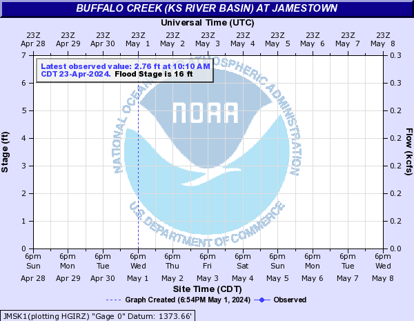
Buffalo Creek (KS River Basin) (Click on an image to go to hydrograph webpage)
JMSK1:
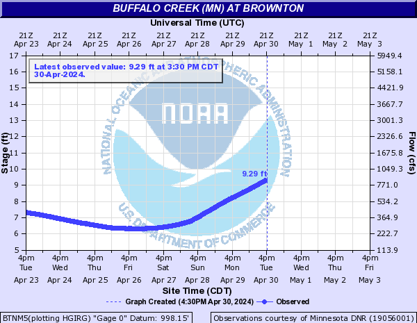
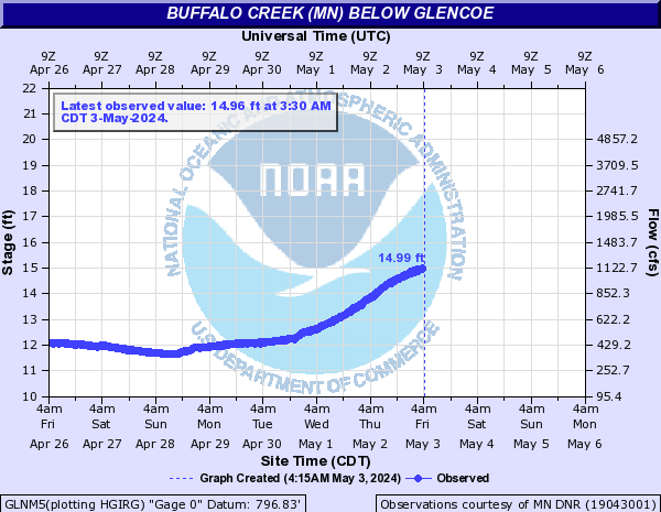
Buffalo Creek (MN) (Click on an image to go to hydrograph webpage)
BTNM5:
GLNM5:
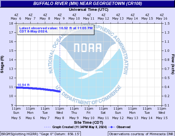
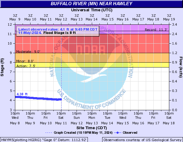
Buffalo River (MN) (Click on an image to go to hydrograph webpage)
BRGM5:
DILM5:

HWYM5:
BGLM5:

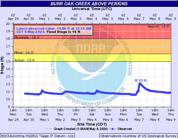
Burr Oak Creek (Click on an image to go to hydrograph webpage)
BOCI4:
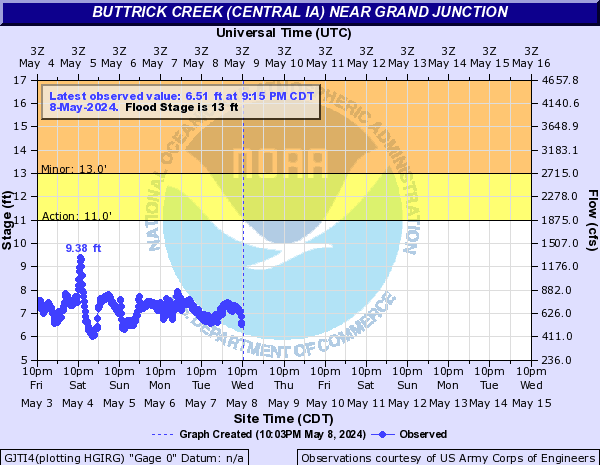
Buttrick Creek (Central IA) (Click on an image to go to hydrograph webpage)
GJTI4:
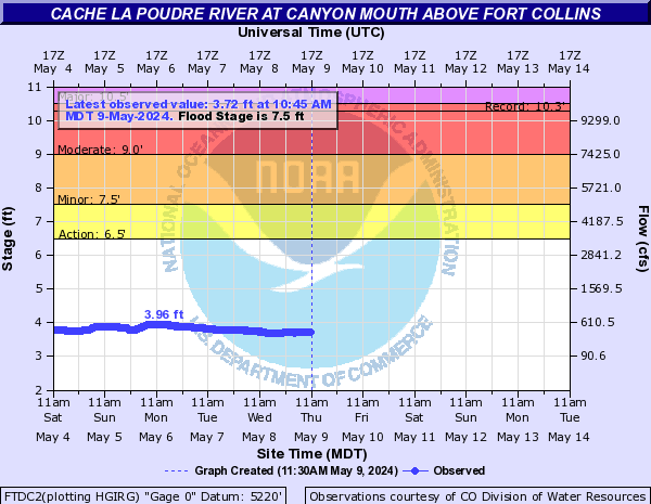
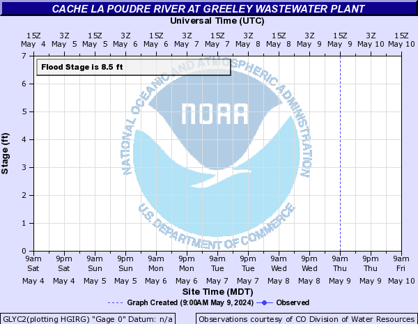
Cache La Poudre River (CO) (Click on an image to go to hydrograph webpage)
FTDC2:
POUC2:

GRPC2:
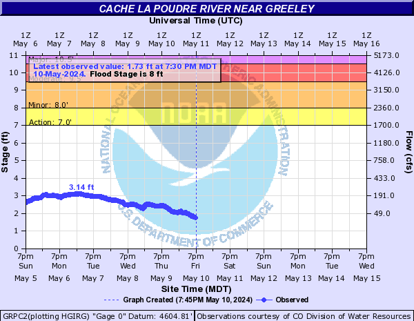
GLYC2:
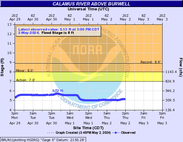
Calamus River (Click on an image to go to hydrograph webpage)
BRLN1:
TLRN1:
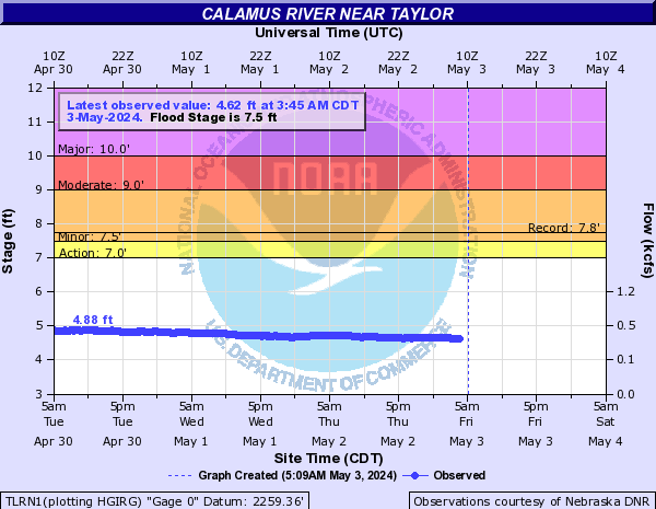
CALN1:

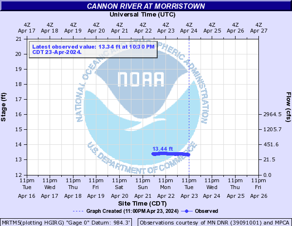
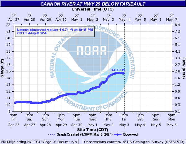
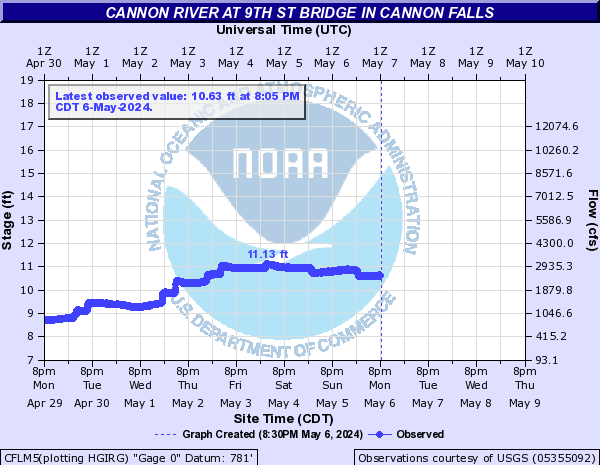
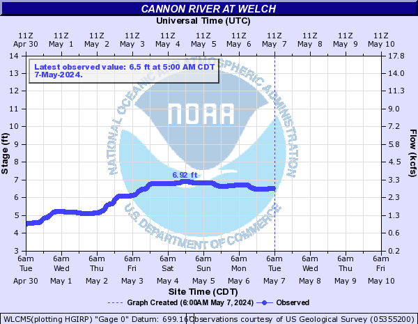
Cannon River (Click on an image to go to hydrograph webpage)
MRTM5:
FRLM5:
NRFM5:

CFLM5:
WLCM5:
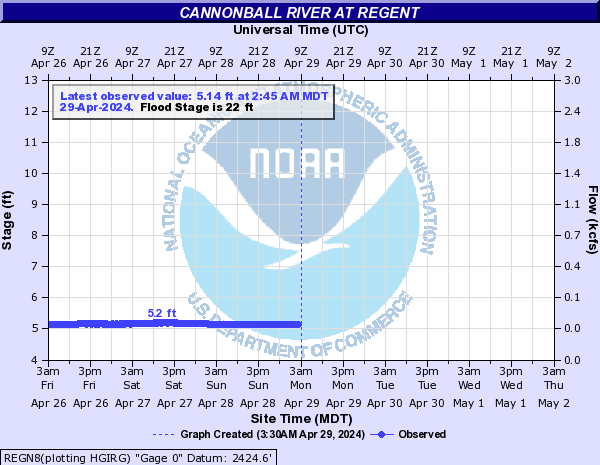
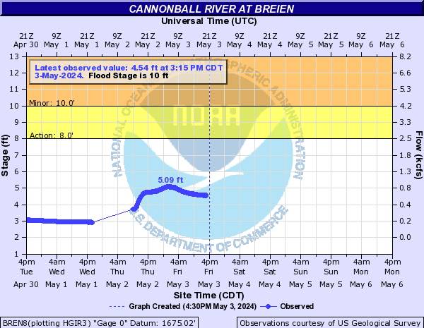
Cannonball River (Click on an image to go to hydrograph webpage)
REGN8:
BREN8:
Cardwell Branch (Click on an image to go to hydrograph webpage)
DENN1:
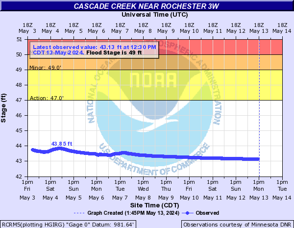
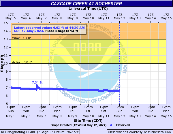
Cascade Creek (Click on an image to go to hydrograph webpage)
RCRM5:
RCCM5:
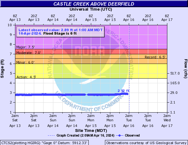
Castle Creek (Click on an image to go to hydrograph webpage)
CTCS2:
DRFS2:

DFBS2:

Cedar Creek (Central SD) (Click on an image to go to hydrograph webpage)
CCPS2:

Cedar Creek (IA) (Click on an image to go to hydrograph webpage)
OKMI4:

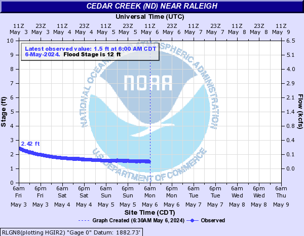
Cedar Creek (ND) (Click on an image to go to hydrograph webpage)
RLGN8:
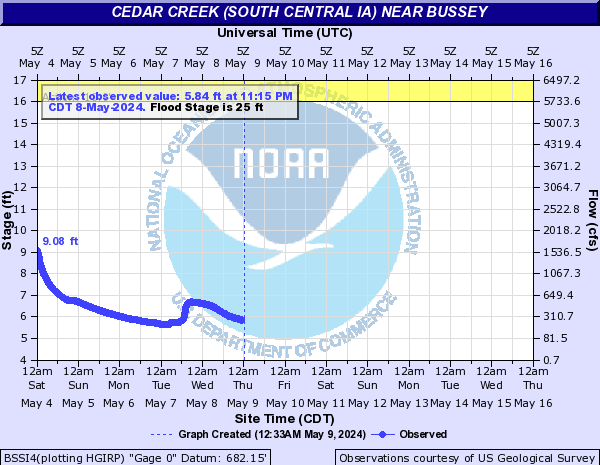
Cedar Creek (South Central IA) (Click on an image to go to hydrograph webpage)
BSSI4:
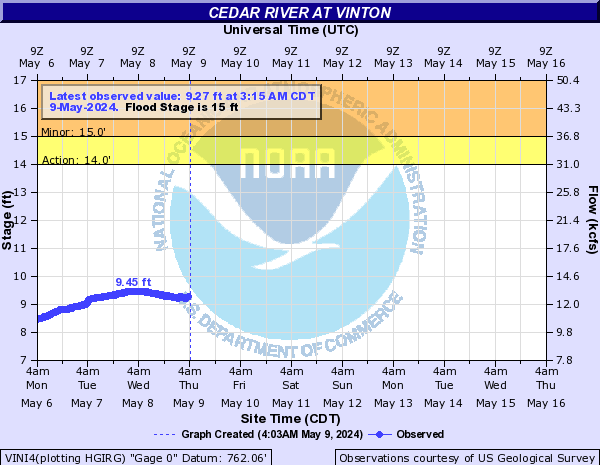
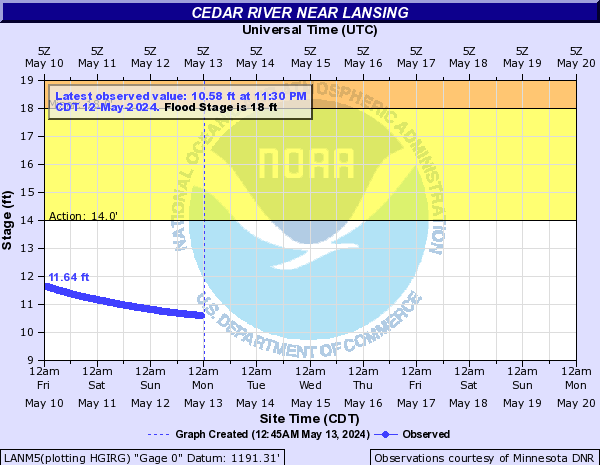
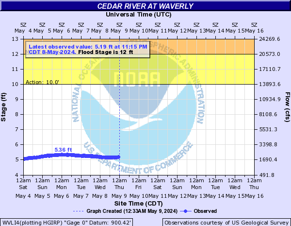
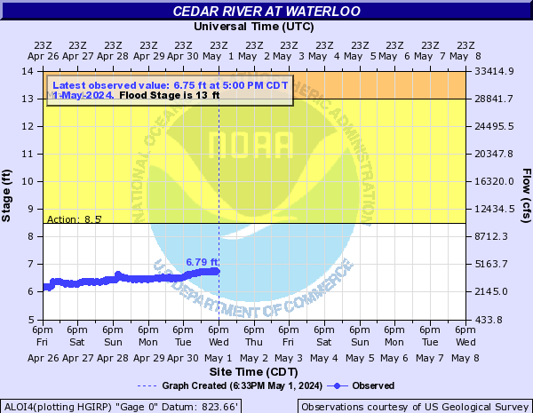
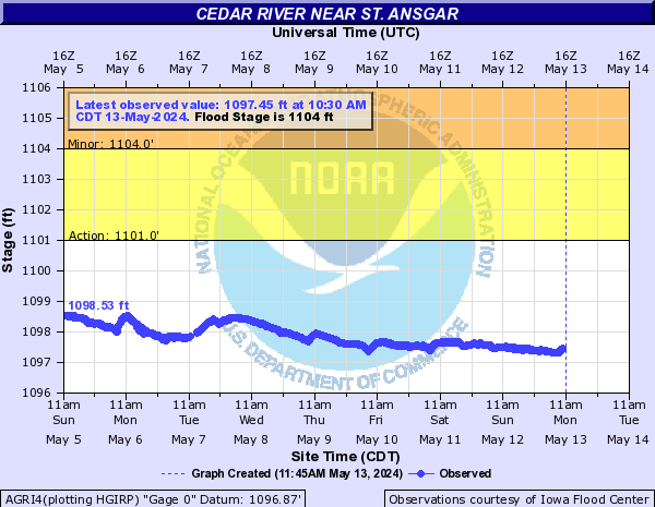
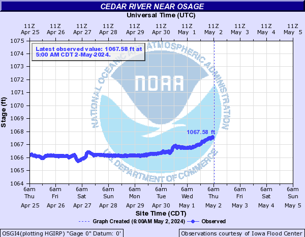
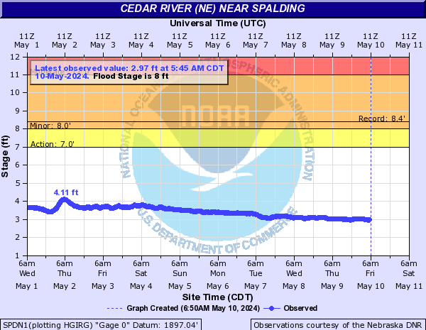
Cedar River (Click on an image to go to hydrograph webpage)
VINI4:
LANM5:
WVLI4:
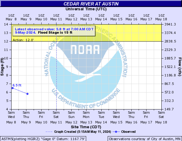
ASTM5:
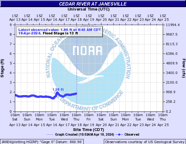
JANI4:
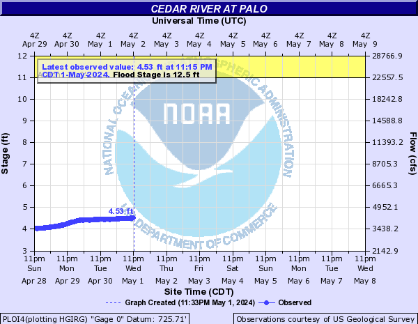
PLOI4:
CIDI4:

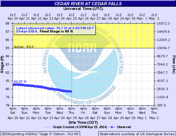
CEDI4:
OTRI4:

ALOI4:
AGRI4:
CROI4:

OSGI4:
CCYI4:

ASNM5:

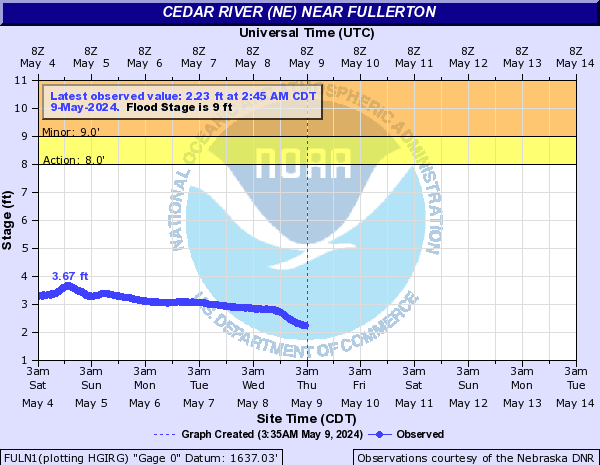
Cedar River (NE) (Click on an image to go to hydrograph webpage)
FULN1:
SPDN1:
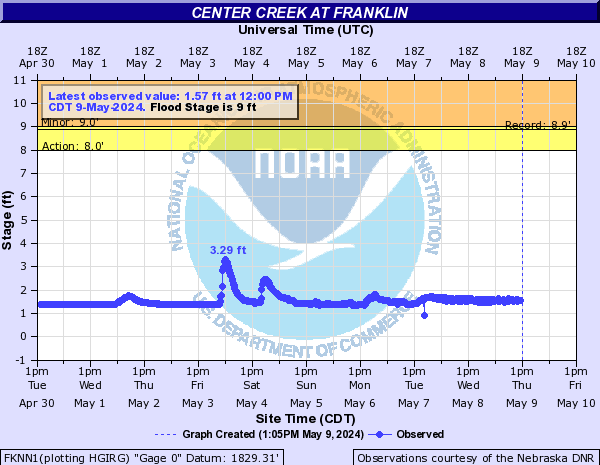
Center Creek (Click on an image to go to hydrograph webpage)
FKNN1:
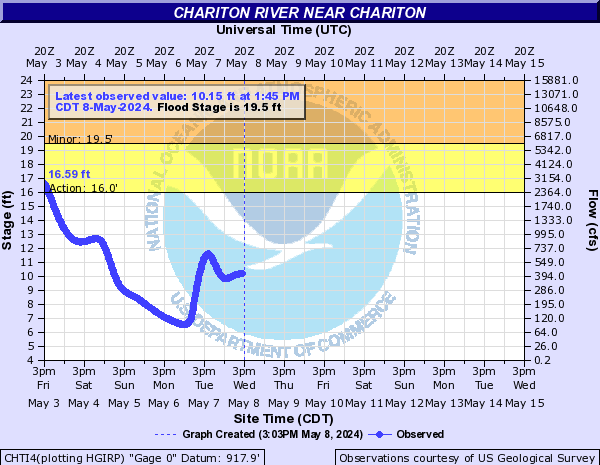
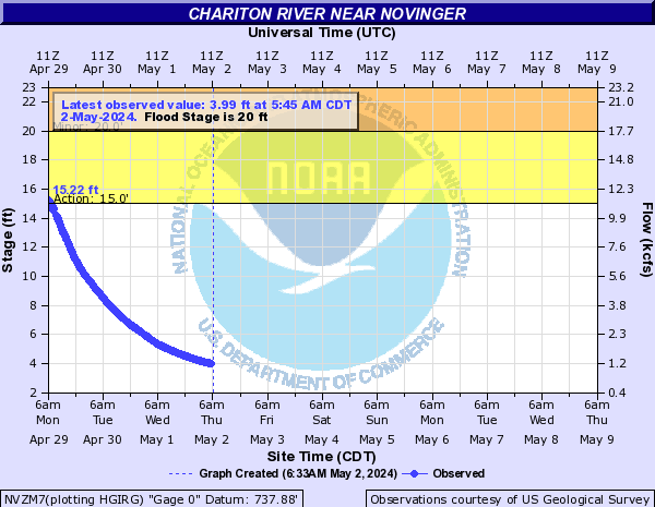
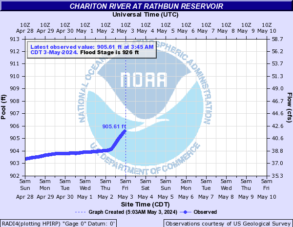
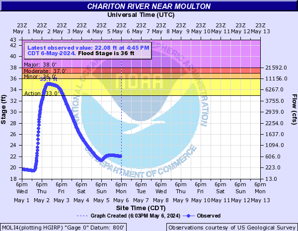
Chariton River (Click on an image to go to hydrograph webpage)
CHTI4:
NVZM7:
RADI4:
RABI4:

MOLI4:
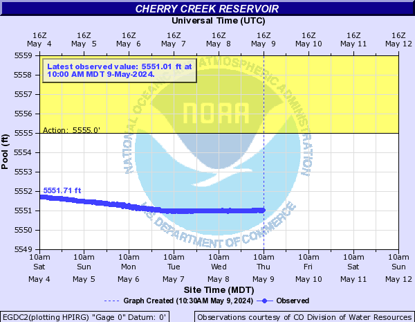
Cherry Creek (CO) (Click on an image to go to hydrograph webpage)
EGDC2:
CDVC2:

CCSC2:

Cherry Creek (SD) (Click on an image to go to hydrograph webpage)
CHCS2:

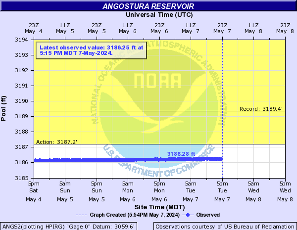
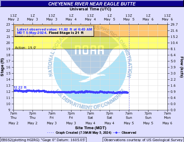
Cheyenne River (Click on an image to go to hydrograph webpage)
EDGS2:

ANGS2:
BFGS2:
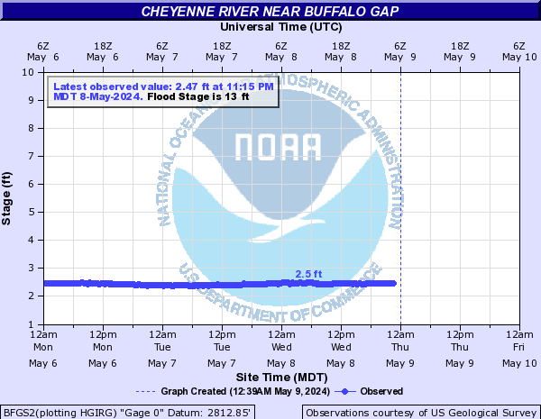
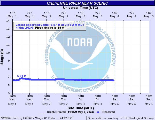
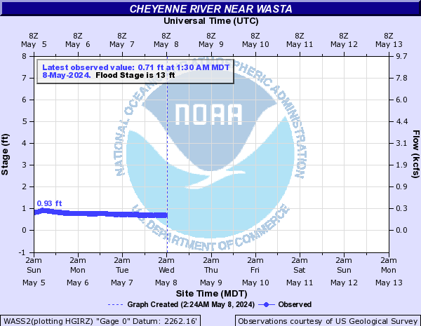
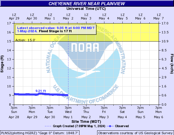
CHRS2:

SCNS2:
WASS2:
PLNS2:
EBSS2:
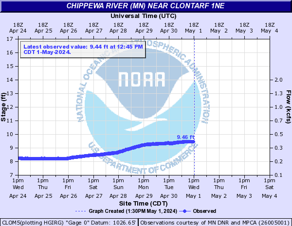
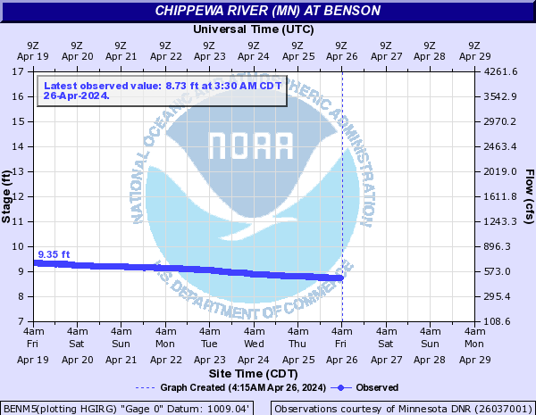
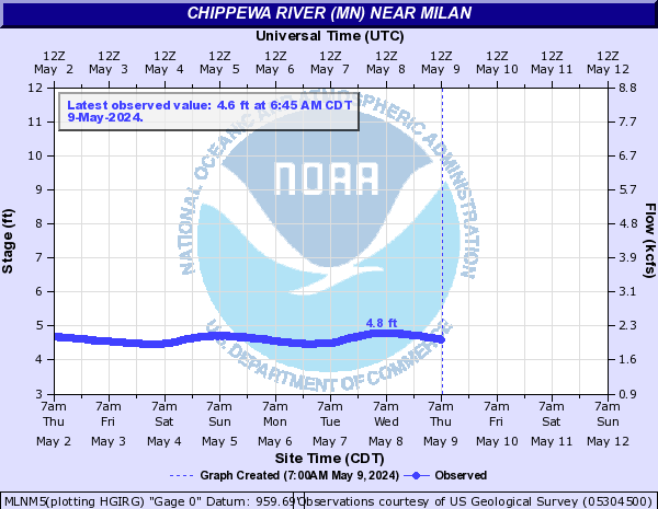
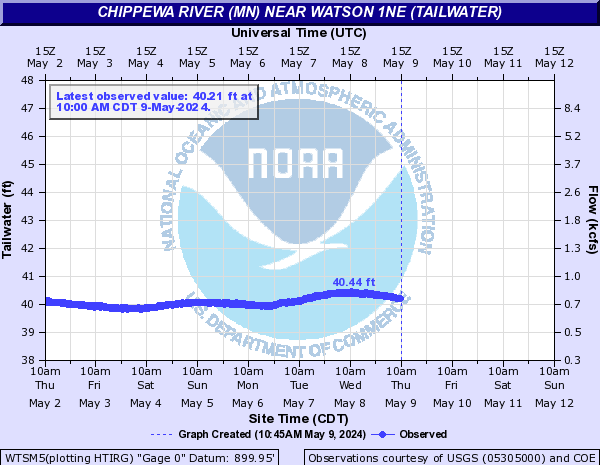
Chippewa River (MN) (Click on an image to go to hydrograph webpage)
CLOM5:
BENM5:
MLNM5:
WTSM5:
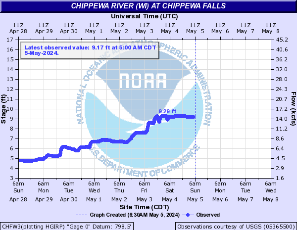
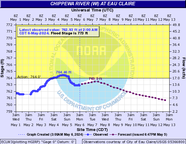
Chippewa River (WI) (Click on an image to go to hydrograph webpage)
CHFW3:
ECTW3:

ECLW3:
DURW3:

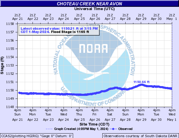
Choteau Creek (Click on an image to go to hydrograph webpage)
CCAS2:
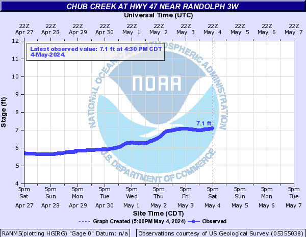
Chub Creek (Click on an image to go to hydrograph webpage)
RANM5:
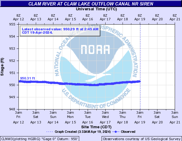
Clam River (Click on an image to go to hydrograph webpage)
CLNW3:
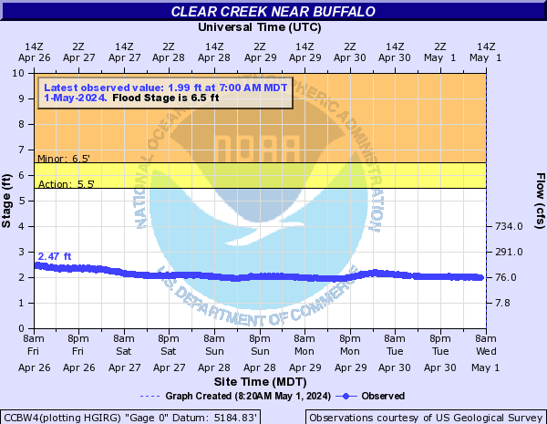
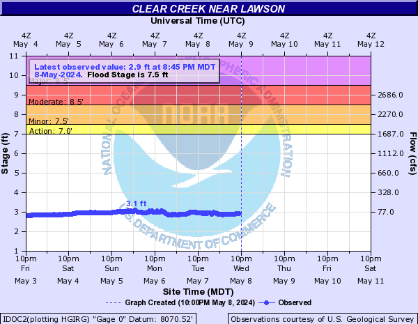
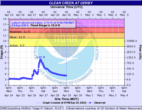
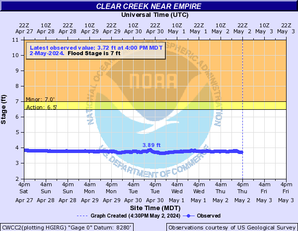
Clear Creek (Click on an image to go to hydrograph webpage)
CCAW4:

SHEN1:

CCBW4:
BCCW4:

Clear Creek (CO) (Click on an image to go to hydrograph webpage)
IDOC2:
GLDC2:

DRBC2:
CWCC2:
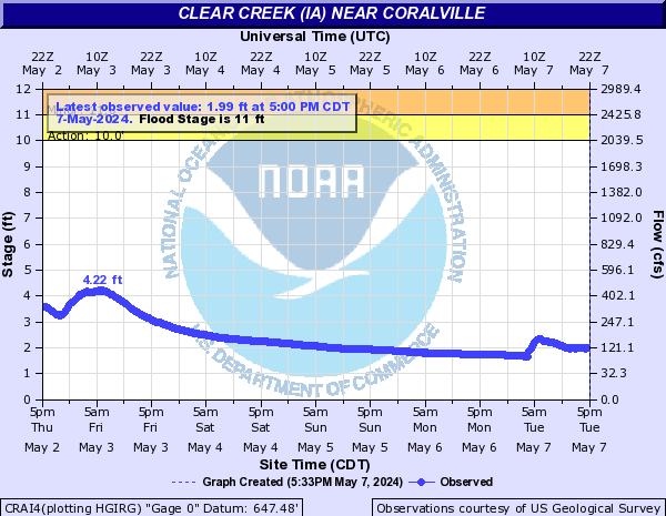
Clear Creek (IA) (Click on an image to go to hydrograph webpage)
OXFI4:

CRAI4:
Clear Lake (North Central IA) (Click on an image to go to hydrograph webpage)
CLKI4:

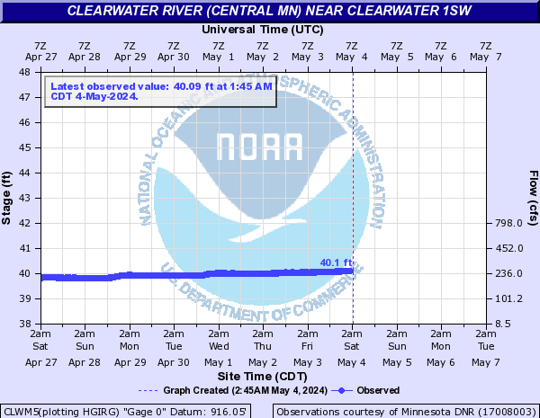
Clearwater River (Central MN) (Click on an image to go to hydrograph webpage)
CLWM5:
Clearwater River (MN) (Click on an image to go to hydrograph webpage)
PLUM5:

RDLM5:

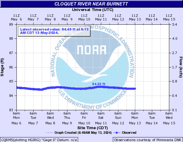
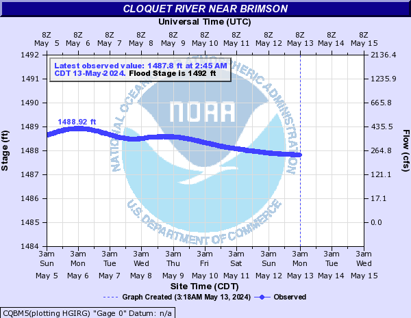
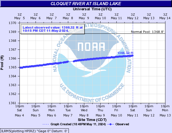
Cloquet River (Click on an image to go to hydrograph webpage)
CQRM5:
CQBM5:
ILRM5:
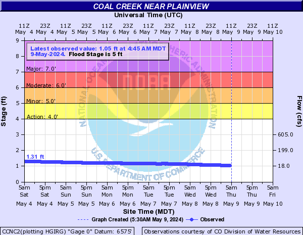
Coal Creek (CO) (Click on an image to go to hydrograph webpage)
CCNC2:
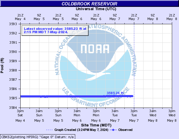
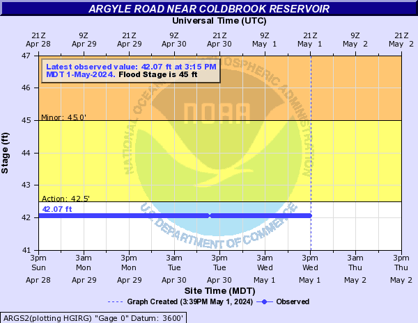
Cold Brook Creek (Click on an image to go to hydrograph webpage)
CBKS2:
ARGS2:
Cole Creek (Click on an image to go to hydrograph webpage)
OMCN1:

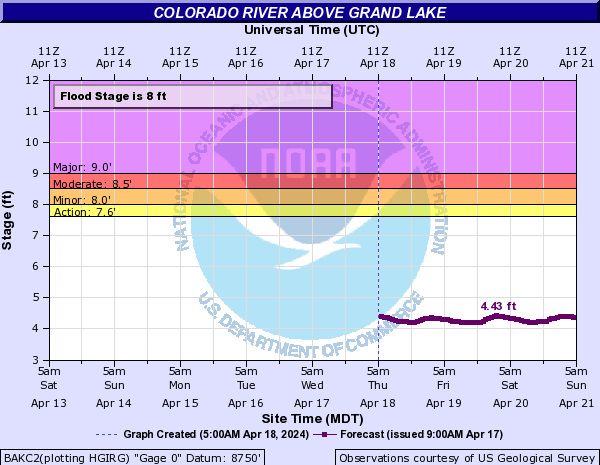
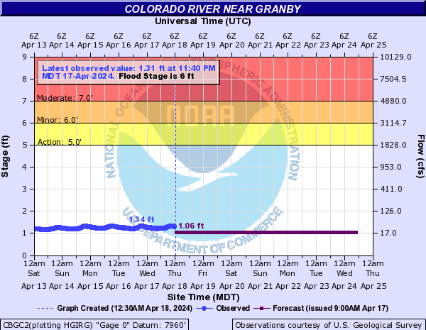
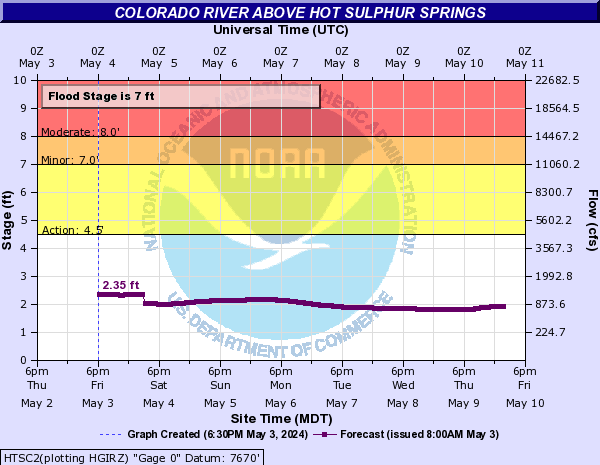
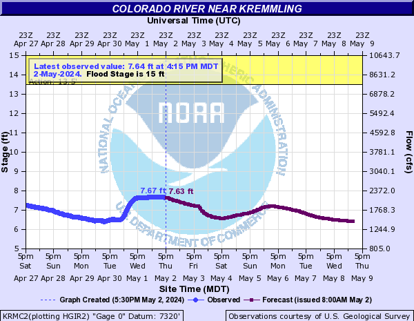
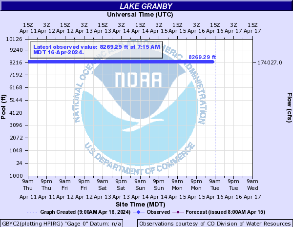
Colorado River (Click on an image to go to hydrograph webpage)
BAKC2:
CBGC2:
HTSC2:
KRMC2:
CAWC2:

GBYC2:
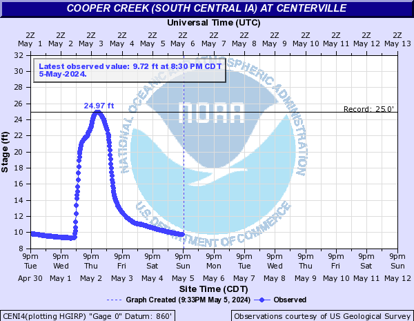
Cooper Creek (South Central IA) (Click on an image to go to hydrograph webpage)
CENI4:
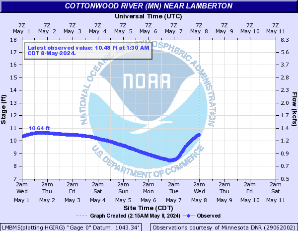
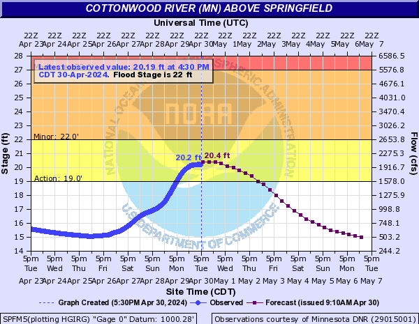
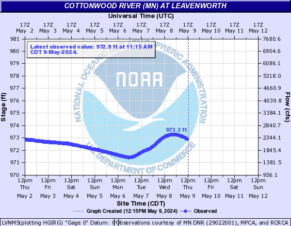
Cottonwood River (MN) (Click on an image to go to hydrograph webpage)
LMBM5:
SPFM5:
LVNM5:
NWUM5:

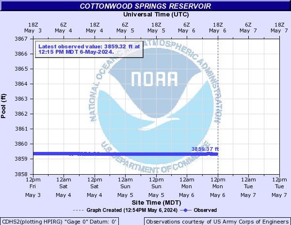
Cottonwood Springs Creek (SD) (Click on an image to go to hydrograph webpage)
CDHS2:
Coulee Creek (Click on an image to go to hydrograph webpage)
BCPS2:

Crow Creek (Click on an image to go to hydrograph webpage)
FEWW4:

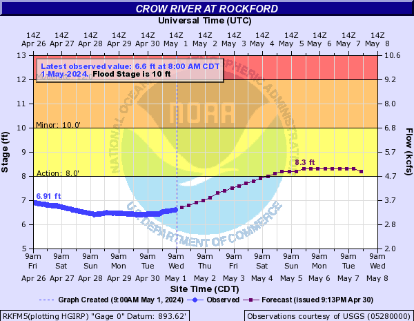
Crow River (Click on an image to go to hydrograph webpage)
RKFM5:
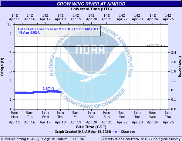
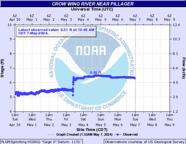
Crow Wing River (Click on an image to go to hydrograph webpage)
NIMM5:
PLGM5:
Crystal Creek (Click on an image to go to hydrograph webpage)
PCCM5:
Davis Creek (Click on an image to go to hydrograph webpage)
DCDN1:

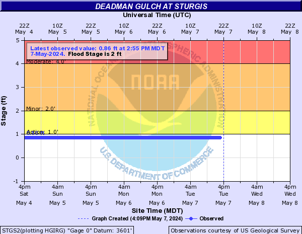
Deadman Gulch (Click on an image to go to hydrograph webpage)
STGS2:
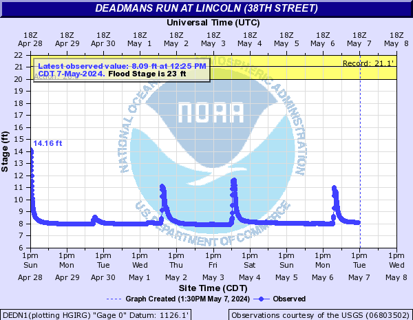
Deadmans Run (Click on an image to go to hydrograph webpage)
DEDN1:
Deep River (IA) (Click on an image to go to hydrograph webpage)
DEPI4:

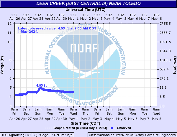
Deer Creek (East Central IA) (Click on an image to go to hydrograph webpage)
TOLI4:
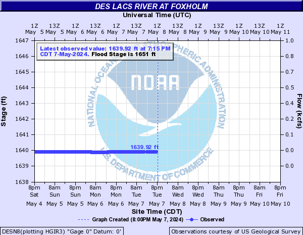
Des Lacs River (Click on an image to go to hydrograph webpage)
DESN8:
Des Moines River (Click on an image to go to hydrograph webpage)
KEQI4:
FODI4:

STRI4:

SFLM7:
SAYI4:
SDTI4:
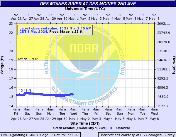
DMOI4:
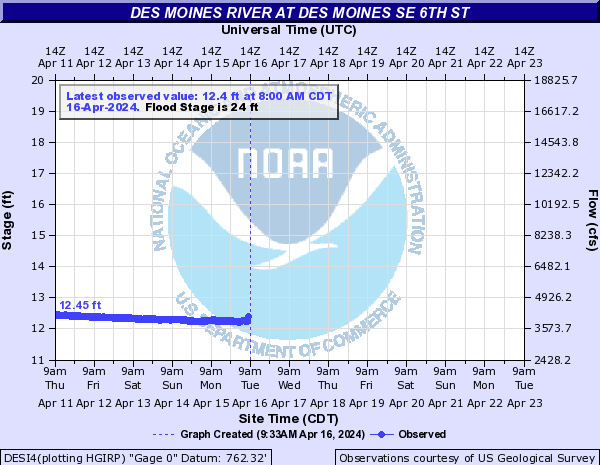
DESI4:
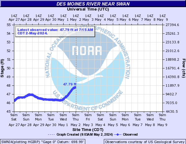
SWNI4:
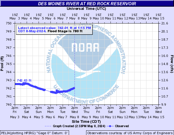
PELI4:
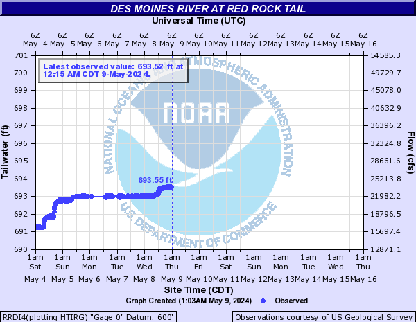
RRDI4:
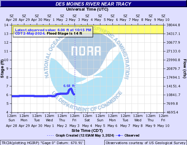
TRCI4:
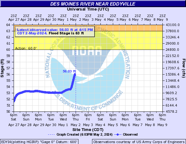
EDYI4:
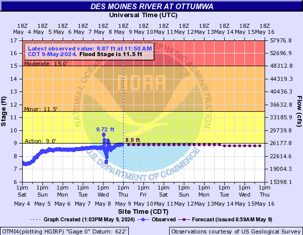
OTMI4:
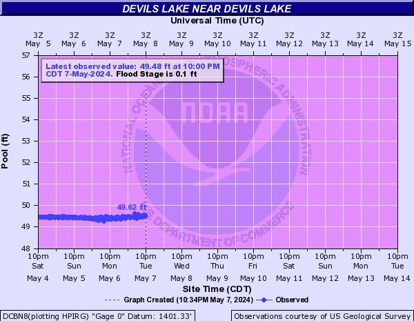
Devils Lake (Click on an image to go to hydrograph webpage)
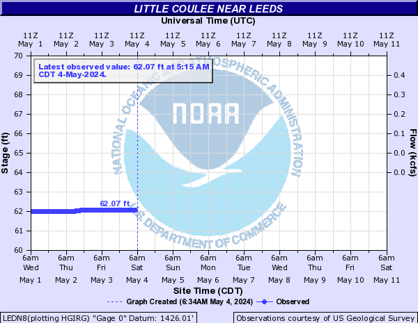
LEDN8:
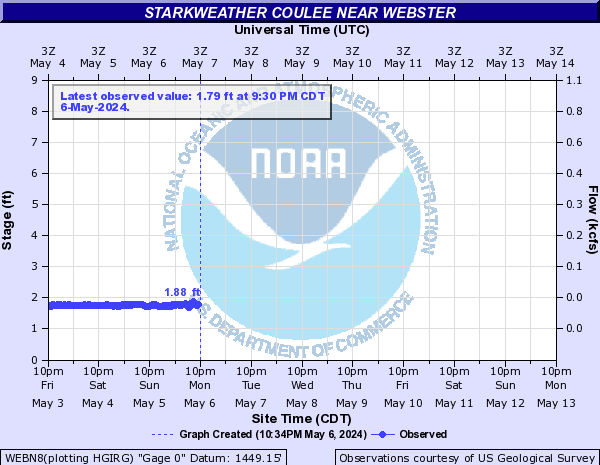
WEBN8:
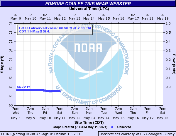
ECTN8:
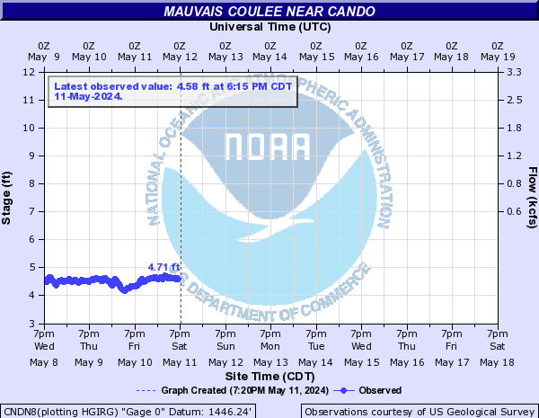
CNDN8:
MCTN8:
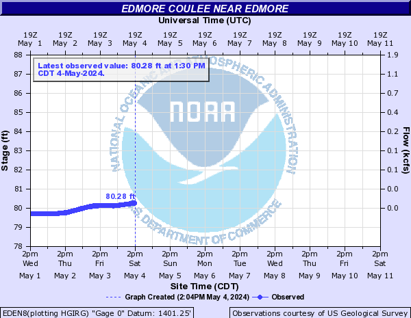
EDEN8:
DLBN8:
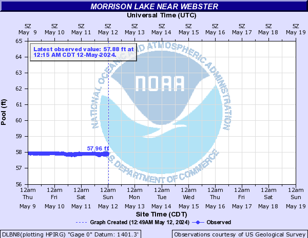
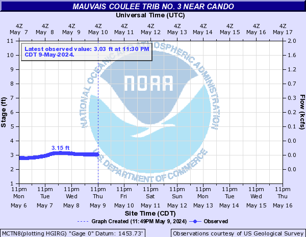
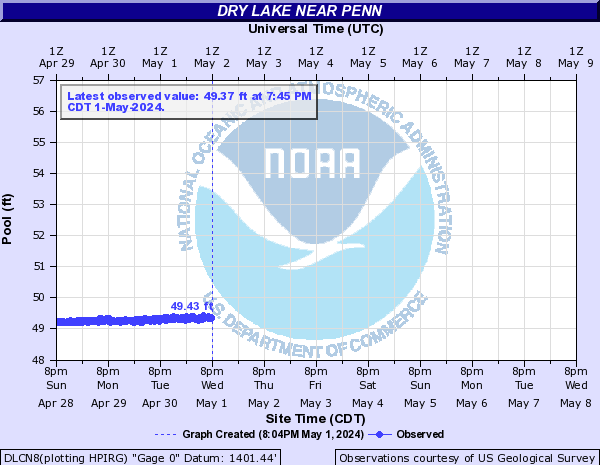
DLCN8:
IRVN8:

DCBN8:
CFCN8:
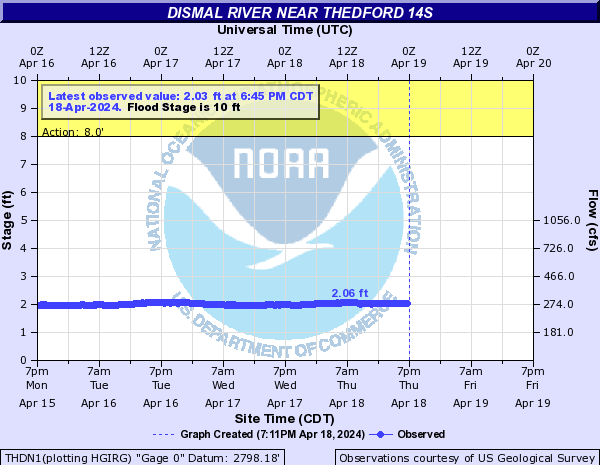
Dismal River (Click on an image to go to hydrograph webpage)
THDN1:
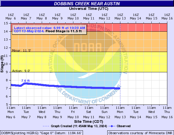
Dobbins Creek (Click on an image to go to hydrograph webpage)
DOBM5:
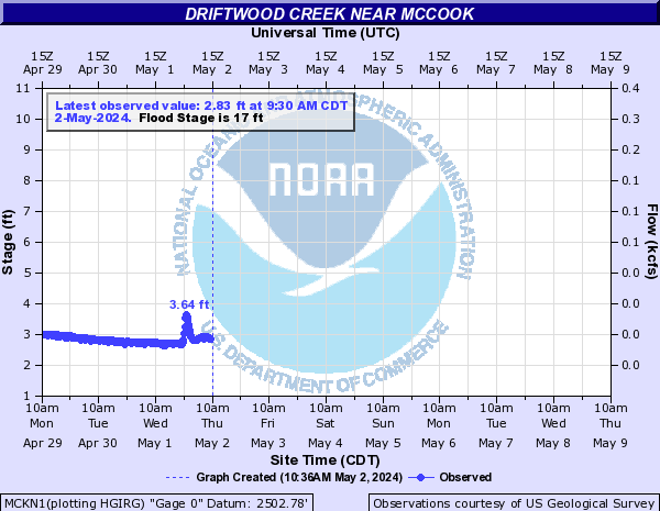
Driftwood Creek (Click on an image to go to hydrograph webpage)
MCKN1:
Dry Creek (CO) (Click on an image to go to hydrograph webpage)
SHDC2:

Dry Run Creek (IA) (Click on an image to go to hydrograph webpage)
DRCI4:

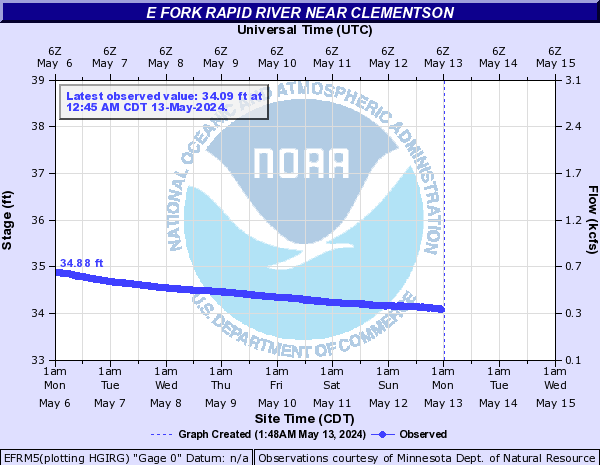
E Fork Rapid River (Click on an image to go to hydrograph webpage)
EFRM5:
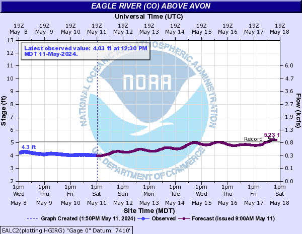
Eagle River (CO) (Click on an image to go to hydrograph webpage)
CSSC2:
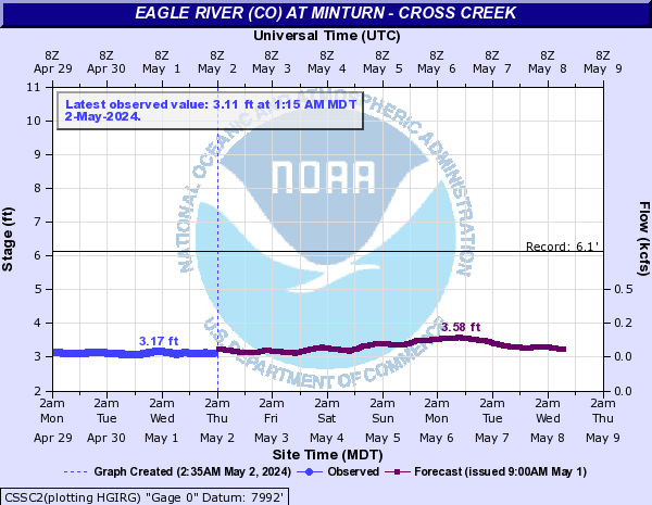
EALC2:
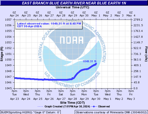
East Branch Blue Earth River (Click on an image to go to hydrograph webpage)
BUEM5:
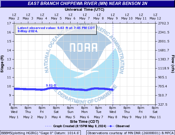
East Branch Chippewa River (MN) (Click on an image to go to hydrograph webpage)
BBBM5:
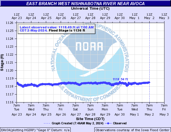
East Branch West Nishnabotna River (Click on an image to go to hydrograph webpage)
EAVI4:
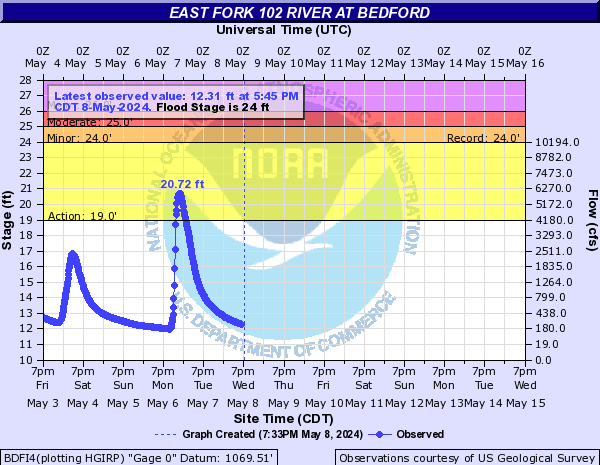
East Fork 102 River (Click on an image to go to hydrograph webpage)
BDFI4:
East Fork Des Moines River (Click on an image to go to hydrograph webpage)
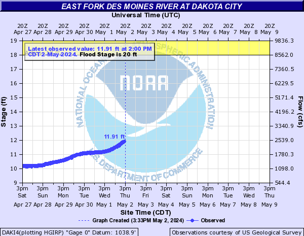
AGNI4:
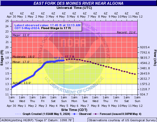
DAKI4:
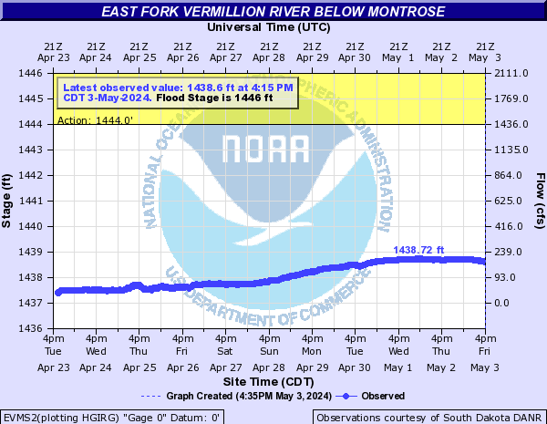
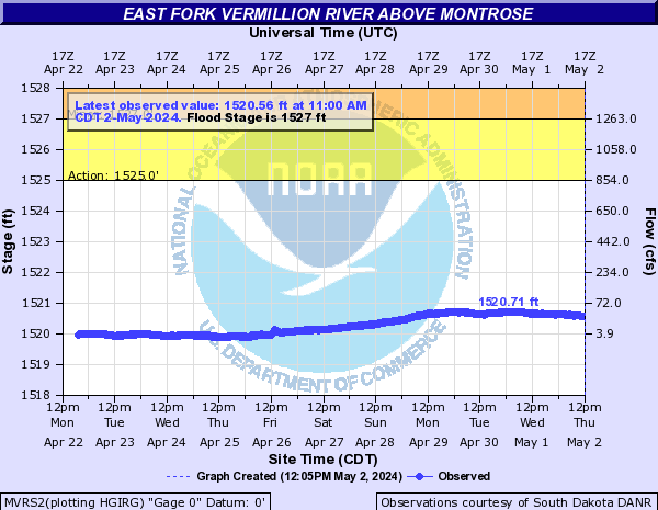
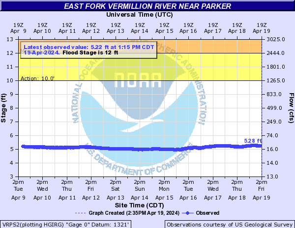
East Fork Vermillion River (Click on an image to go to hydrograph webpage)
EVMS2:
MVRS2:
VRPS2:
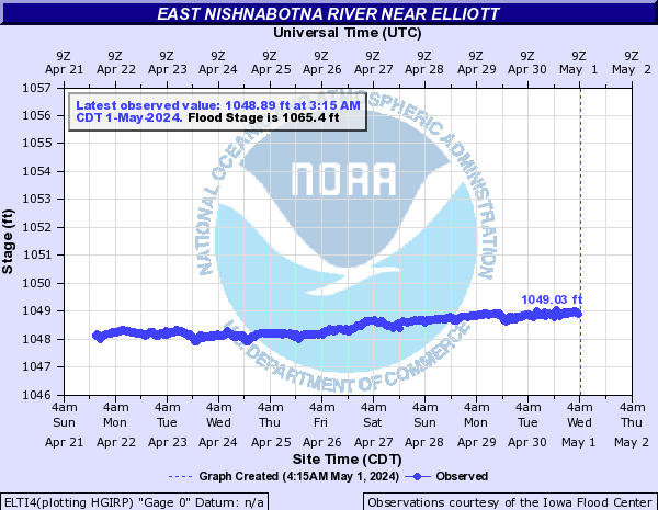
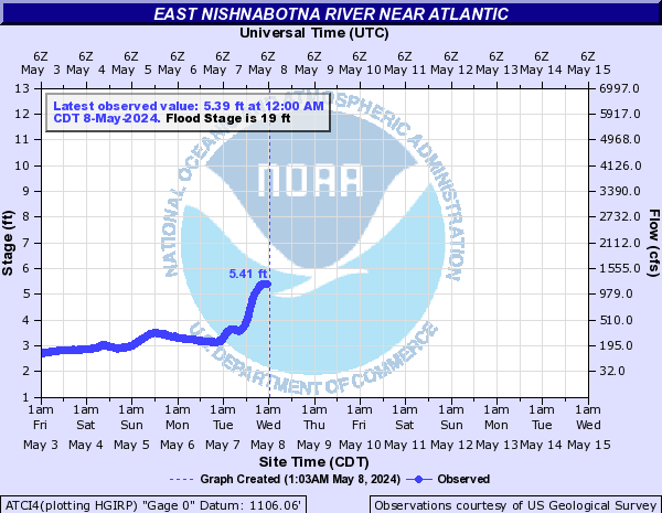
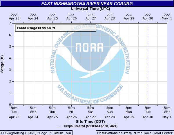
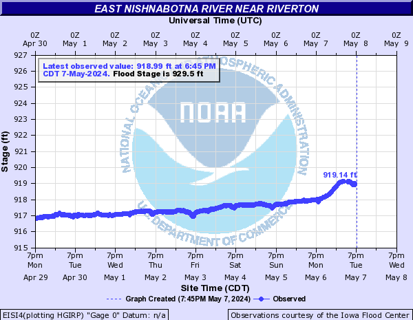
East Nishnabotna River (Click on an image to go to hydrograph webpage)
ELTI4:
ATCI4:
RDOI4:

COBI4:
SHNI4:

EISI4:
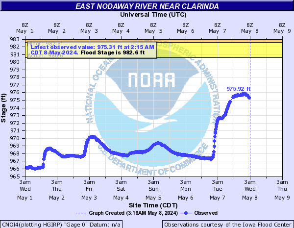
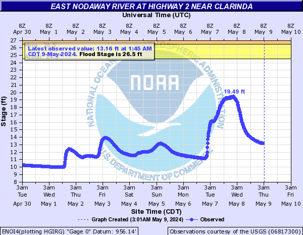
East Nodaway River (Click on an image to go to hydrograph webpage)
CNOI4:
ENOI4:
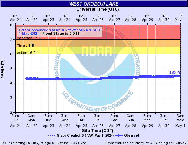
East Okoboji Lake (Click on an image to go to hydrograph webpage)
EOLI4:

EWOI4:

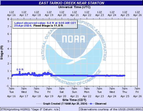
East Tarkio Creek (Click on an image to go to hydrograph webpage)
ETRI4:
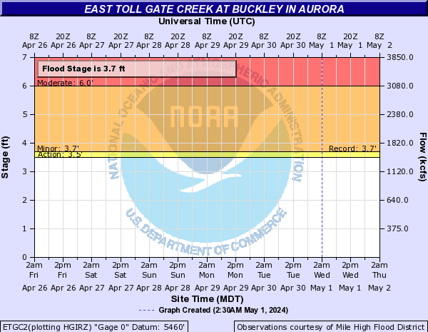
East Toll Gate Creek (CO) (Click on an image to go to hydrograph webpage)
ETGC2:
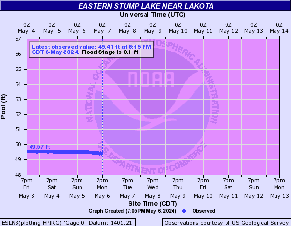
Eastern Stump Lake (Click on an image to go to hydrograph webpage)
ESLN8:
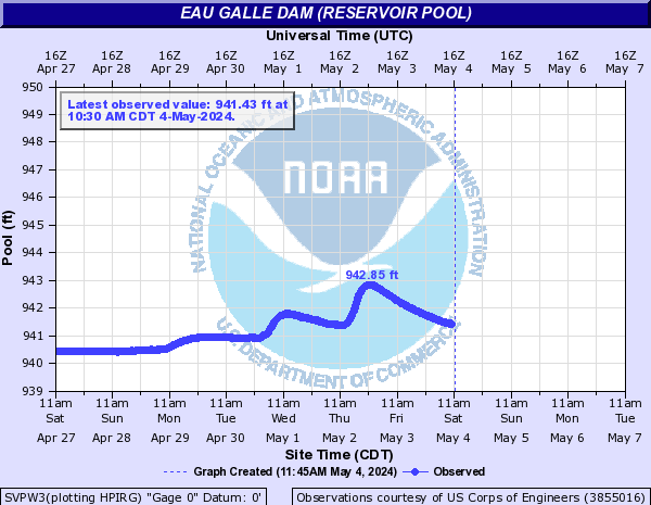
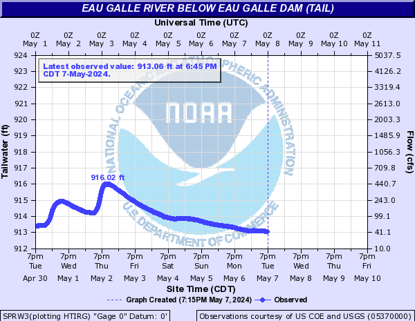
Eau Galle River (Click on an image to go to hydrograph webpage)
SVPW3:
SPRW3:
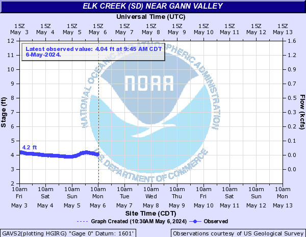
Elk Creek (Click on an image to go to hydrograph webpage)
SUMM7:

Elk Creek (KS) (Click on an image to go to hydrograph webpage)
CLDK1:

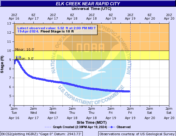
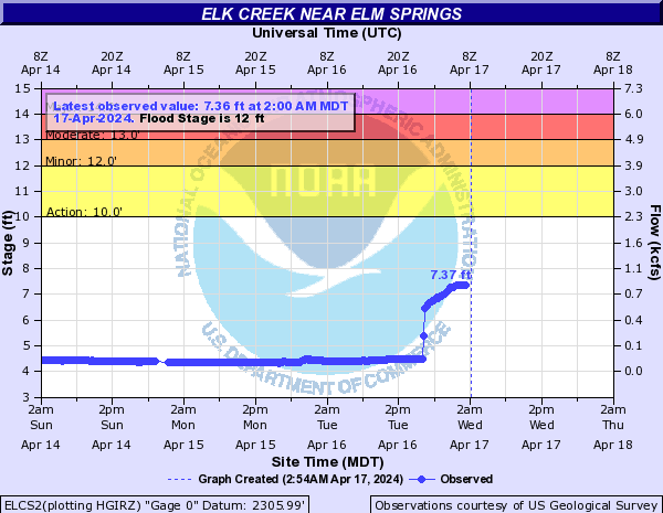
Elk Creek (SD) (Click on an image to go to hydrograph webpage)
GAVS2:
EKCS2:
ELCS2:
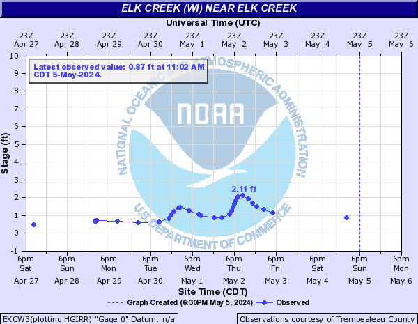
Elk Creek (WI) (Click on an image to go to hydrograph webpage)
EKCW3:
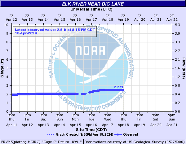
Elk River (Click on an image to go to hydrograph webpage)
ERVM5:
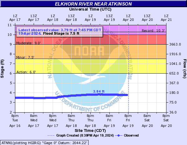
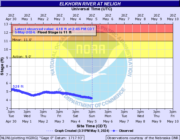
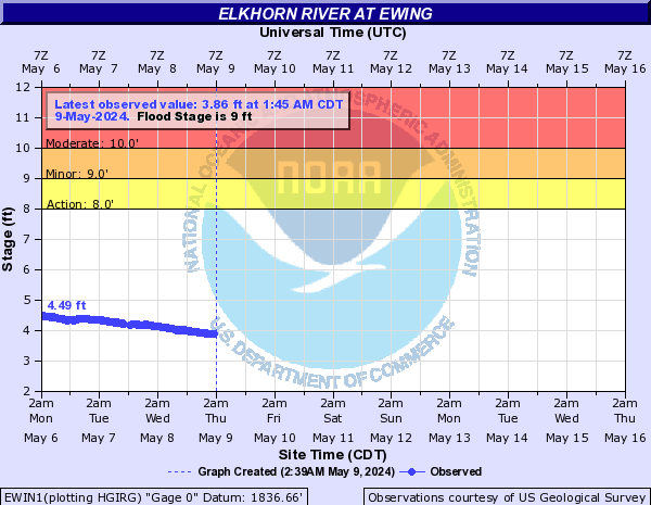
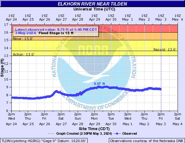
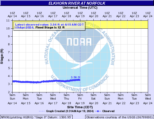
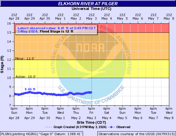
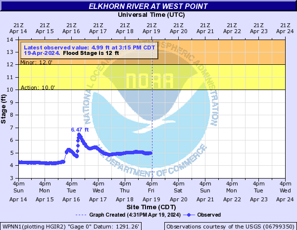
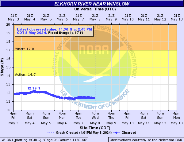
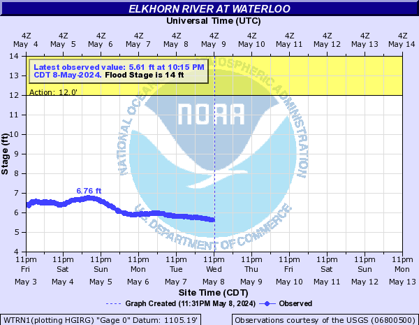
Elkhorn River (Click on an image to go to hydrograph webpage)
ATNN1:
NLIN1:
EWIN1:
TLDN1:
NFKN1:
PLGN1:
WPNN1:
WLON1:
WTRN1:
Elliott Creek (Click on an image to go to hydrograph webpage)
ECLI4:

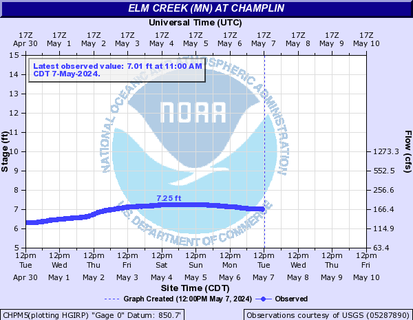
Elm Creek (MN) (Click on an image to go to hydrograph webpage)
CHPM5:
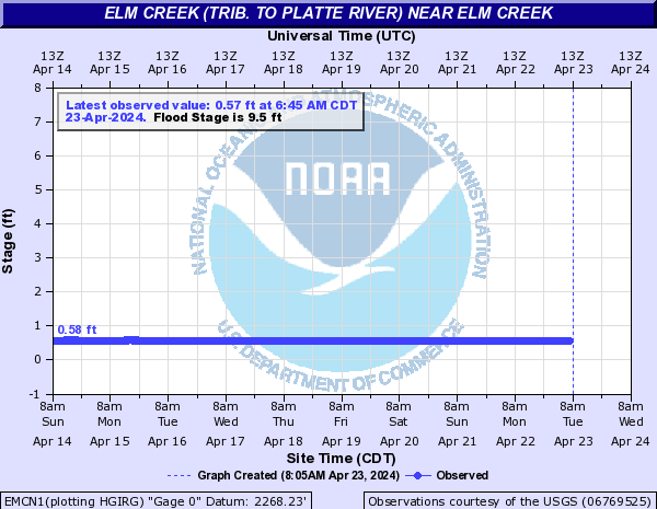
Elm Creek (trib. to Platte River) (Click on an image to go to hydrograph webpage)
EMCN1:
Elm Creek (trib. to Republican River) (Click on an image to go to hydrograph webpage)
AMBN1:

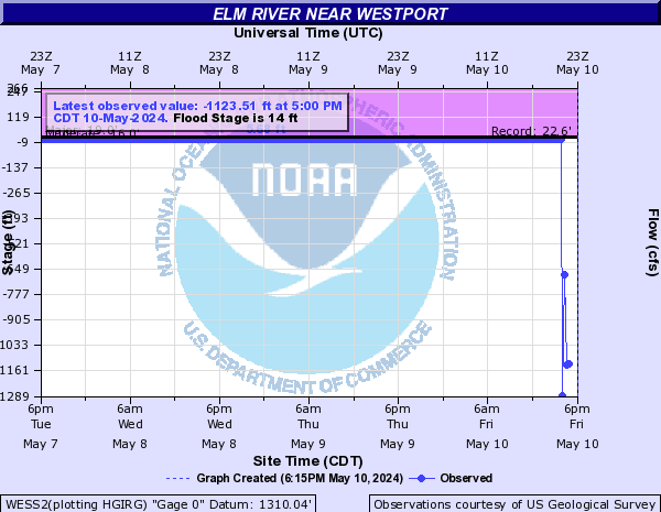
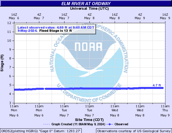
Elm River (Click on an image to go to hydrograph webpage)
ERFS2:

ELMN8:

NBEN8:

WESS2:
ORDS2:
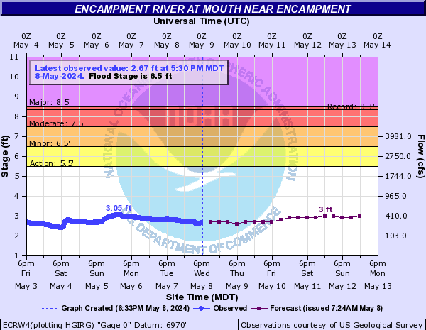
Encampment River (Click on an image to go to hydrograph webpage)
ECRW4:
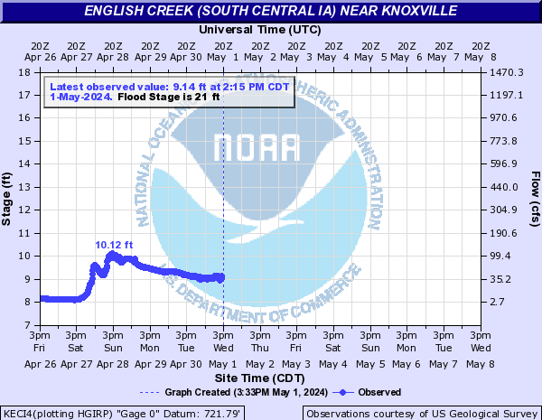
English Creek (South Central IA) (Click on an image to go to hydrograph webpage)
KECI4:
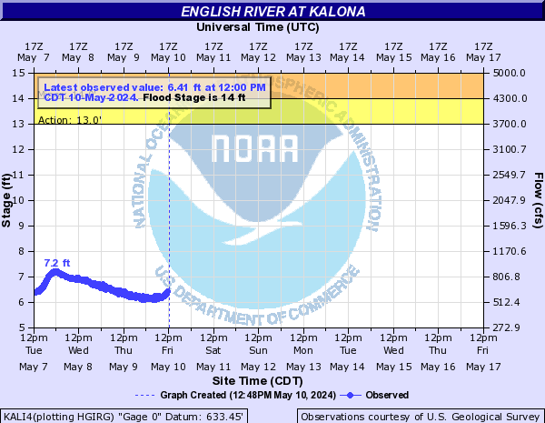
English River (Click on an image to go to hydrograph webpage)
KALI4:
NEPI4:

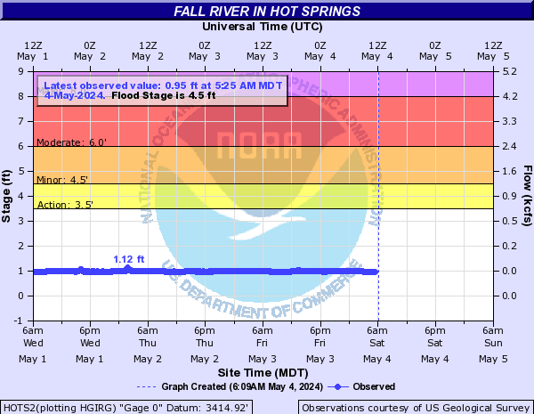
Fall River (SD) (Click on an image to go to hydrograph webpage)
HOTS2:
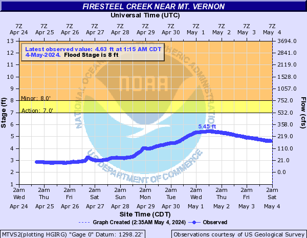
Firesteel Creek (Click on an image to go to hydrograph webpage)
MTVS2:
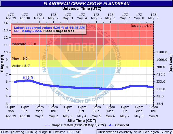
Flandreau Creek (Click on an image to go to hydrograph webpage)
FCRS2:
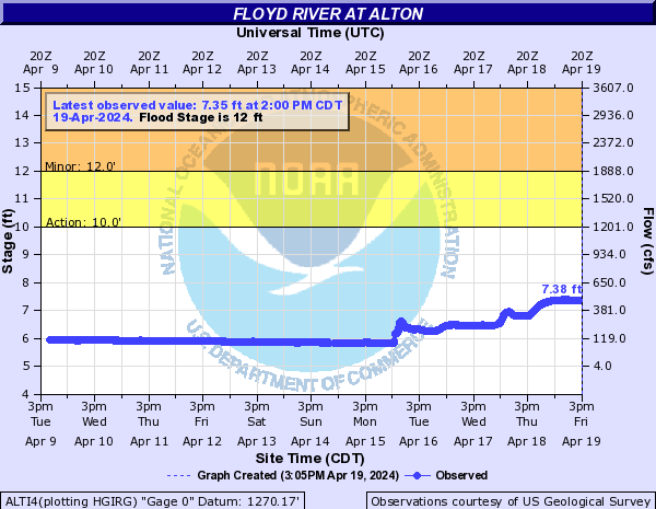
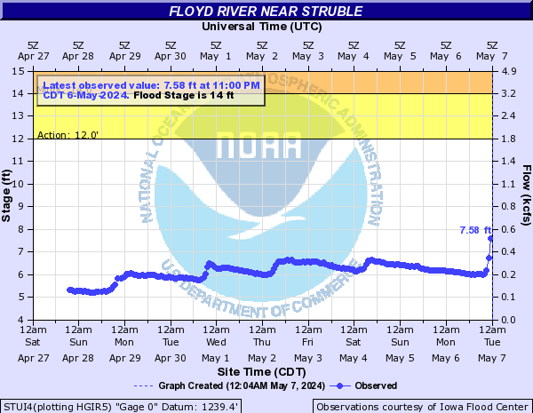
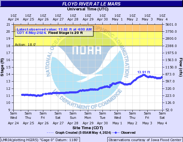
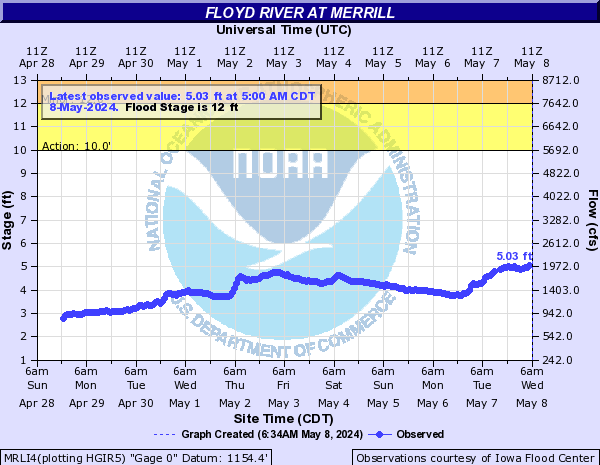
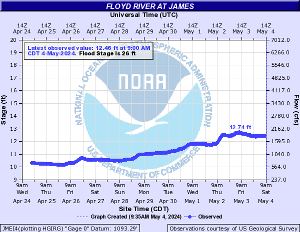
Floyd River (Click on an image to go to hydrograph webpage)
SHLI4:

SFRI4:

ALTI4:
STUI4:
LMRI4:
MRLI4:
JMEI4:
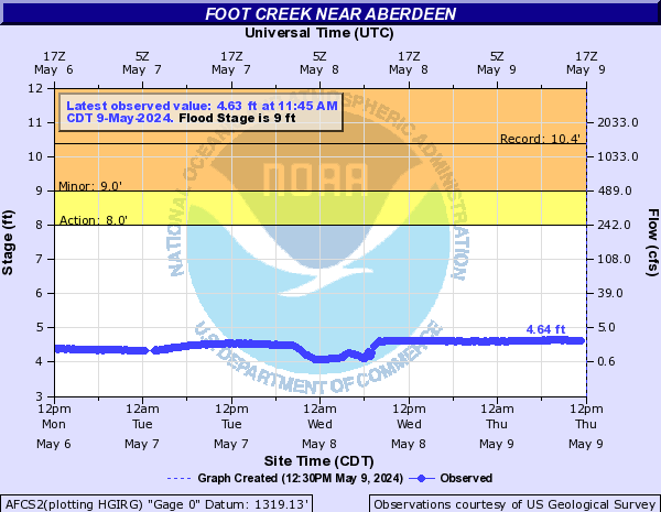
Foot Creek (Click on an image to go to hydrograph webpage)
AFCS2:
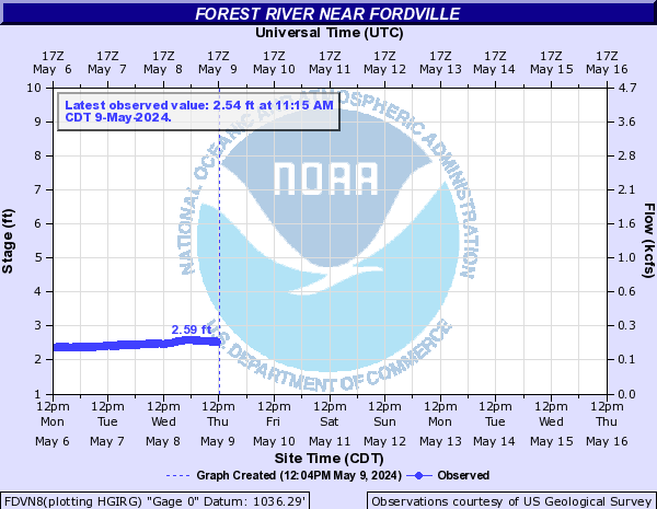
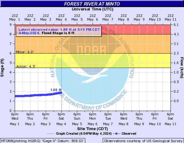
Forest River (Click on an image to go to hydrograph webpage)
FDVN8:
MTON8:
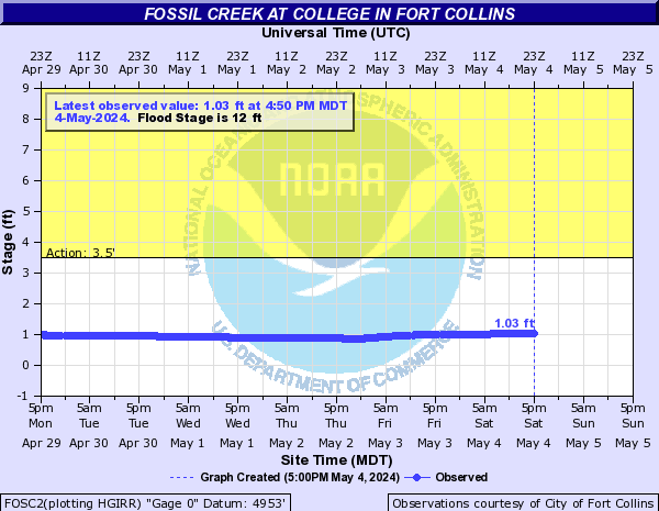
Fossil Creek (CO) (Click on an image to go to hydrograph webpage)
FOSC2:
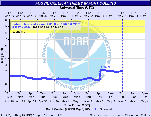
FSSC2:
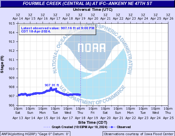
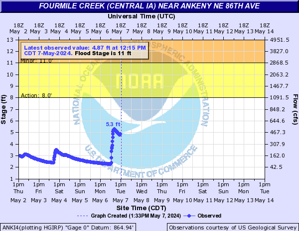
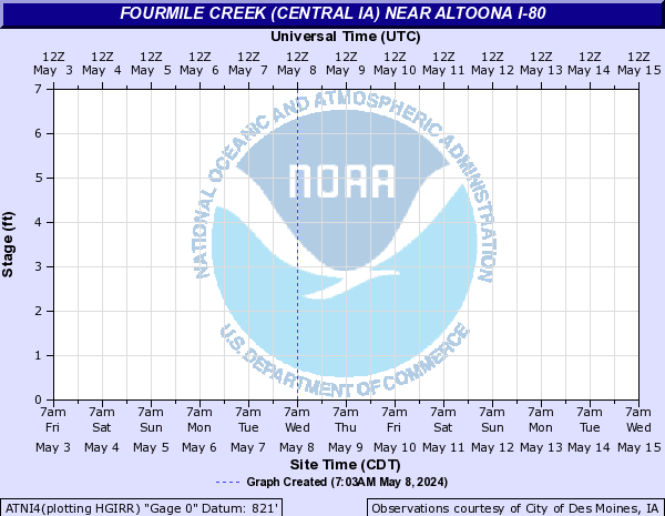
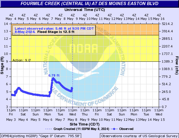
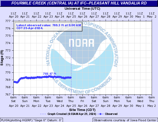
Fourmile Creek (Central IA) (Click on an image to go to hydrograph webpage)
AKNI4:

ANFI4:
ANKI4:
ALFI4:

ATNI4:
DFMI4:
PLHI4:
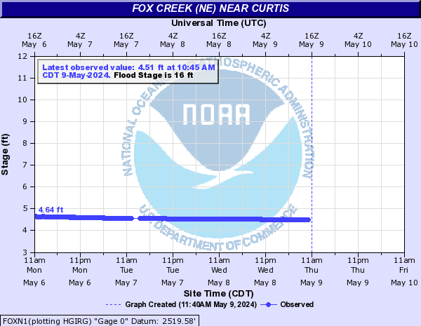
Fox Creek (NE) (Click on an image to go to hydrograph webpage)
FOXN1:
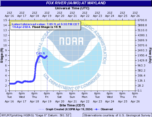
Fox River (IA/MO) (Click on an image to go to hydrograph webpage)
BMFI4:

WYLM7:
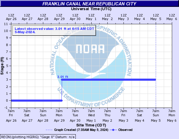
Franklin Canal (Click on an image to go to hydrograph webpage)
RECN1:
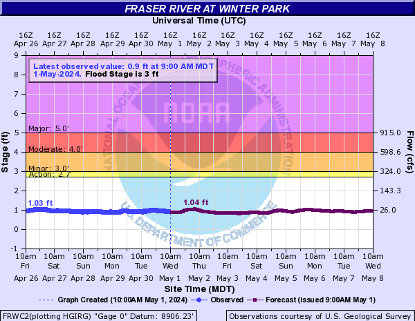
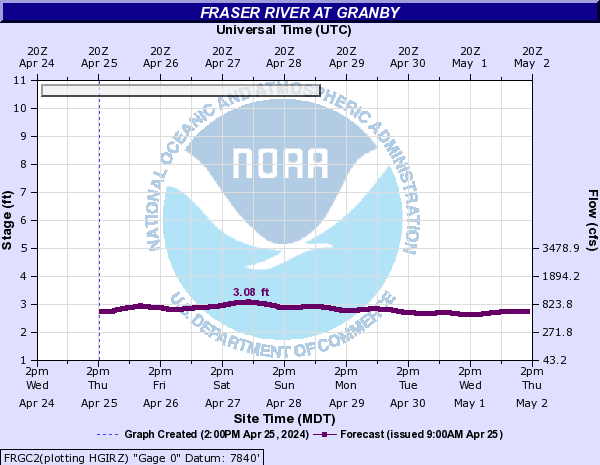
Fraser River (CO) (Click on an image to go to hydrograph webpage)
FRWC2:
FRGC2:
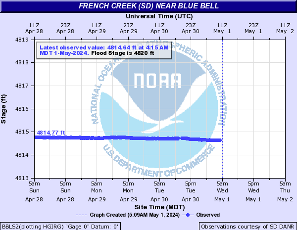
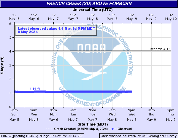
French Creek (SD) (Click on an image to go to hydrograph webpage)
BBLS2:
FRNS2:
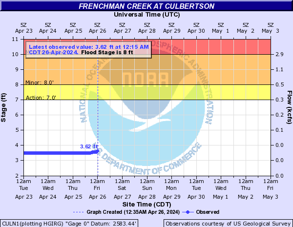
Frenchman Creek (Click on an image to go to hydrograph webpage)
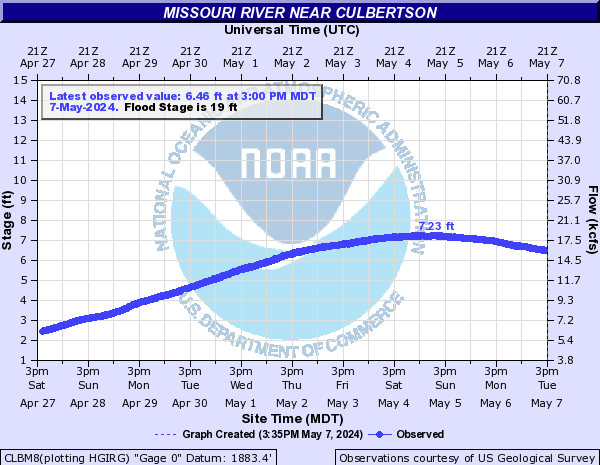
CULN1:
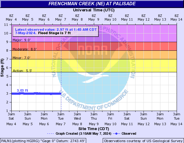
Frenchman Creek (NE) (Click on an image to go to hydrograph webpage)
PALN1:
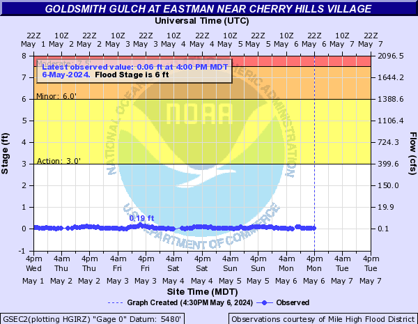
Goldsmith Gulch (CO) (Click on an image to go to hydrograph webpage)
GSEC2:
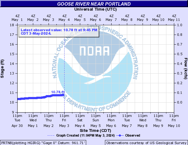
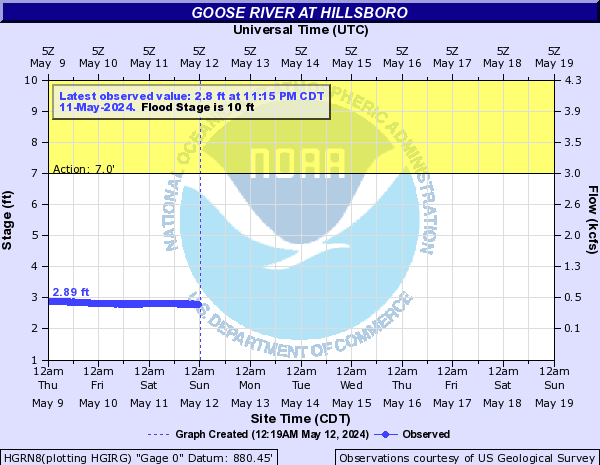
Goose River (Click on an image to go to hydrograph webpage)
PRTN8:
HGRN8:
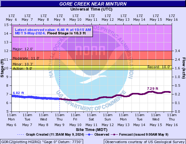
Gore Creek (Click on an image to go to hydrograph webpage)
GORC2:
GRVC2:

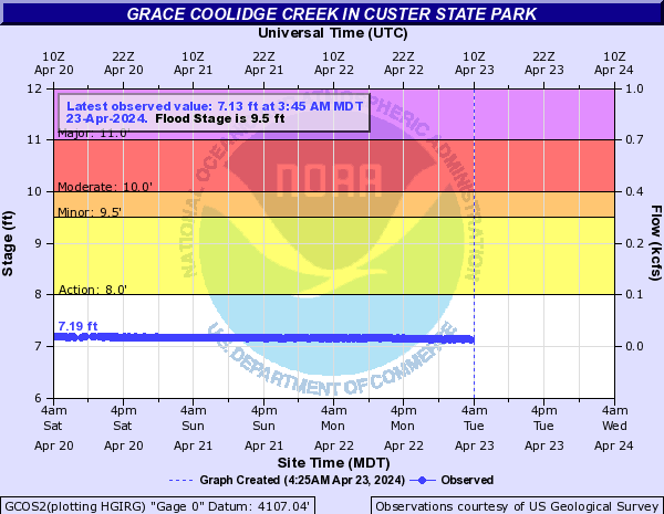
Grace Coolidge Creek (Click on an image to go to hydrograph webpage)
GCOS2:
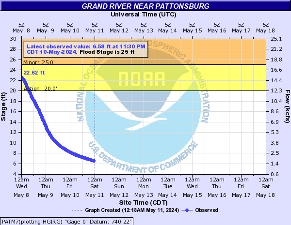
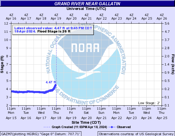
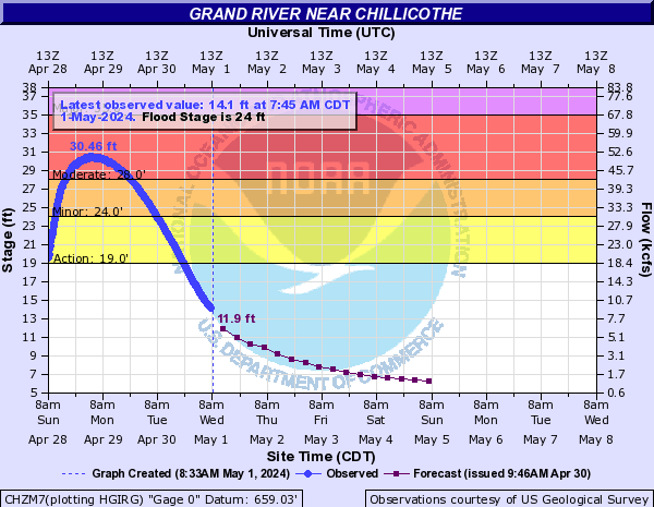
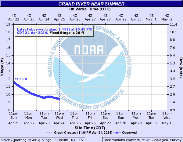
Grand River (Click on an image to go to hydrograph webpage)
PATM7:
GAZM7:
CHZM7:
SNZM7:
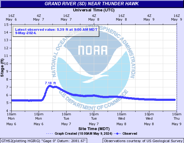
Grand River (SD) (Click on an image to go to hydrograph webpage)
SHAS2:
LIES2:

GTHS2:
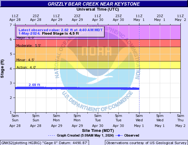
Grizzly Bear Creek (Click on an image to go to hydrograph webpage)
GNKS2:
Haines Branch (Click on an image to go to hydrograph webpage)
LHBN1:

Hanging Woman Creek (Click on an image to go to hydrograph webpage)
HWCM8:

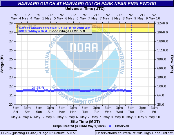
Harvard Gulch (CO) (Click on an image to go to hydrograph webpage)
HGPC2:
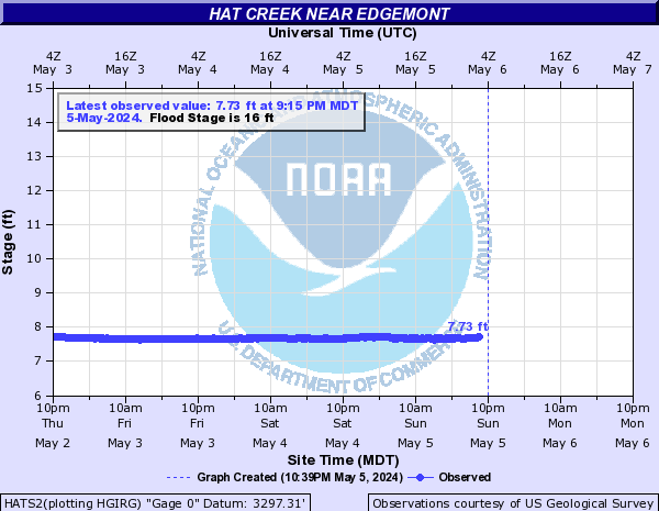
Hat Creek (Click on an image to go to hydrograph webpage)
HATS2:
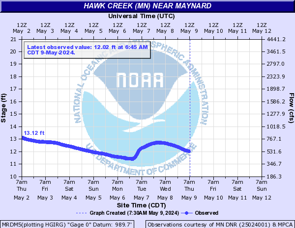
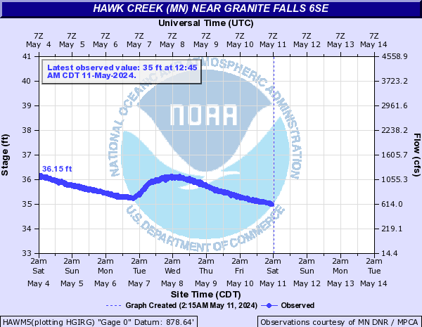
Hawk Creek (MN) (Click on an image to go to hydrograph webpage)
MRDM5:
HAWM5:
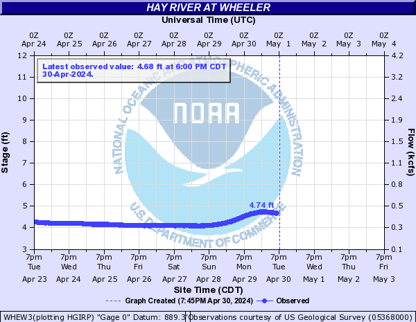
Hay River (Click on an image to go to hydrograph webpage)
WHEW3:
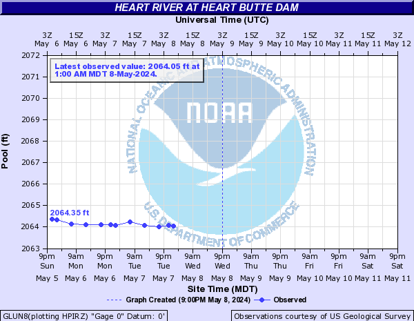
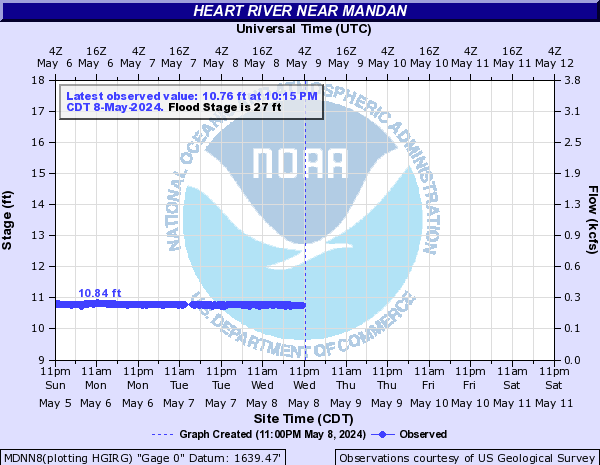
Heart River (Click on an image to go to hydrograph webpage)
DNDN8:

GLUN8:
MDNN8:
Hickman Branch (Click on an image to go to hydrograph webpage)
HKMN1:
HCKN1:

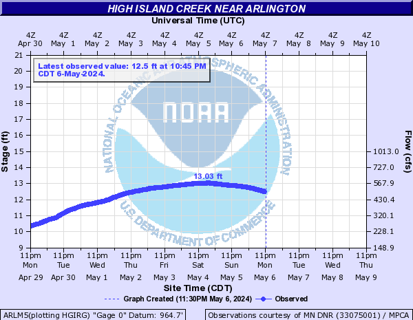
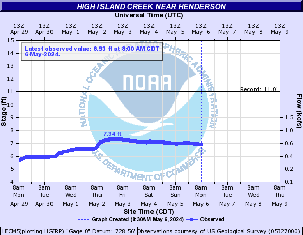
High Island Creek (Click on an image to go to hydrograph webpage)
ARLM5:
HICM5:
Holmes Creek (Click on an image to go to hydrograph webpage)
DTON1:

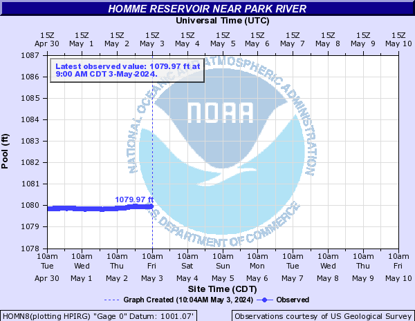
Homme Reservoir (Click on an image to go to hydrograph webpage)
HOMN8:
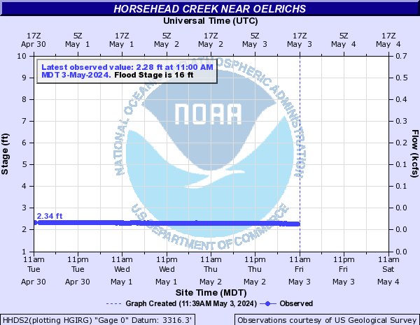
Horsehead Creek (Click on an image to go to hydrograph webpage)
HHDS2:
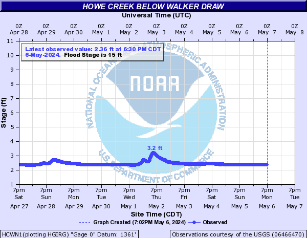
Howe Creek (Click on an image to go to hydrograph webpage)
HCWN1:
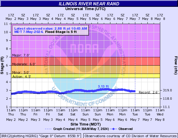
Illinois River (CO) (Click on an image to go to hydrograph webpage)
IRRC2:
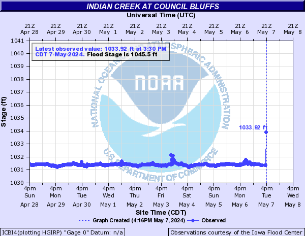
Indian Creek (Click on an image to go to hydrograph webpage)
EMNI4:

EMEI4:
ICBI4:
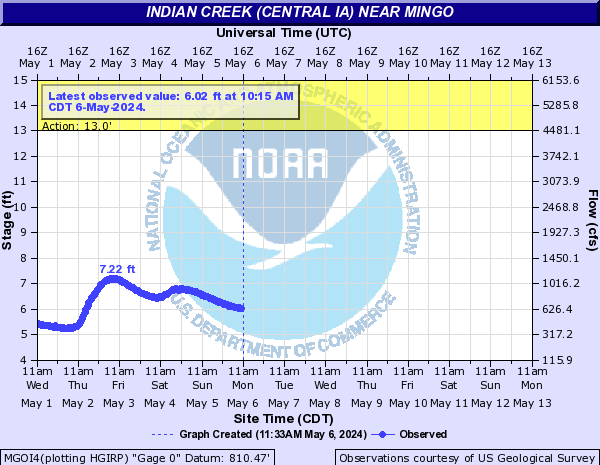
Indian Creek (Central IA) (Click on an image to go to hydrograph webpage)
MGOI4:
Indian Creek (Eastern IA) (Click on an image to go to hydrograph webpage)
MRNI4:

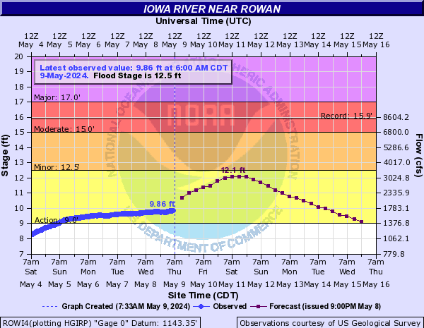
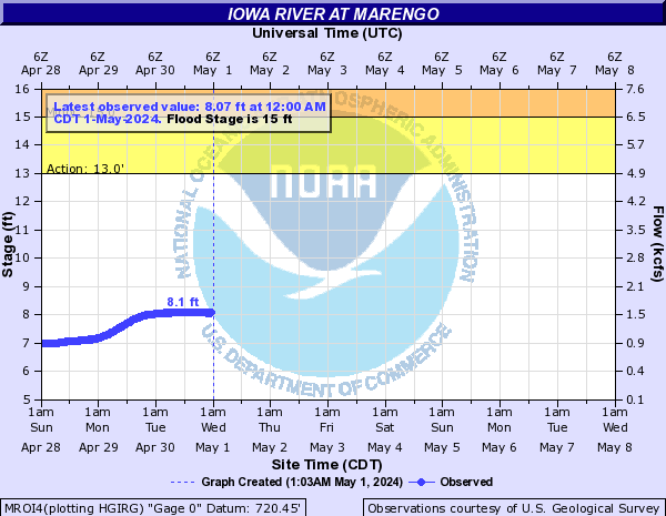
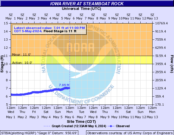
Iowa River (Click on an image to go to hydrograph webpage)
BPLI4:

ROWI4:
MROI4:
STBI4:
CRVI4:

MIWI4:

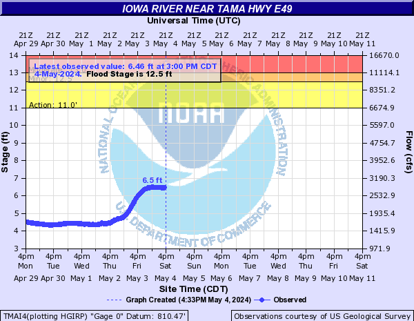
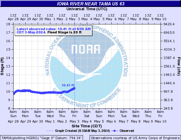
TMAI4:
IOWI4:

LNTI4:

TAMI4:
CHEI4:

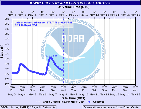
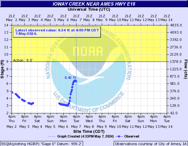
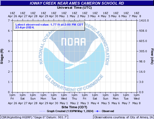
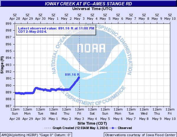
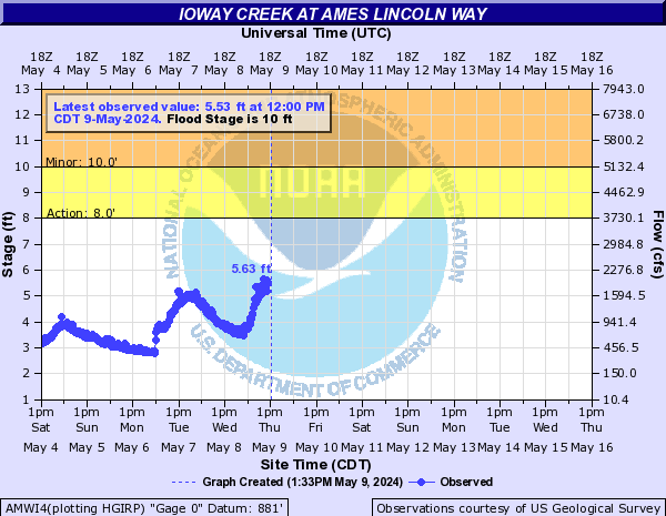
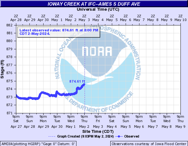
Ioway Creek (Click on an image to go to hydrograph webpage)
BSCI4:
ESQI4:
BSQI4:
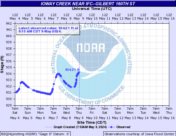
CSRI4:
AMQI4:
AMWI4:
AMDI4:
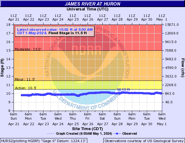
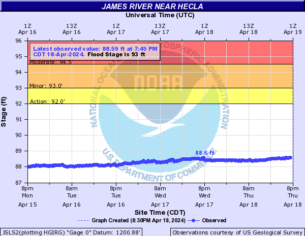
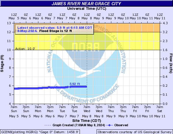
James River (Click on an image to go to hydrograph webpage)
HURS2:
JSLS2:
GCEN8:
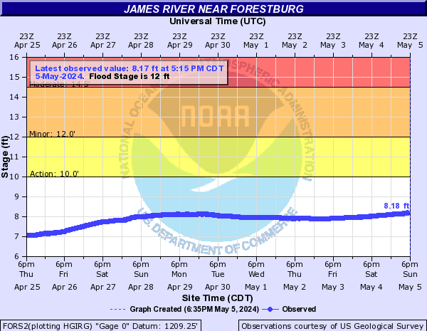
FORS2:
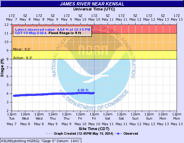
KSLN8:
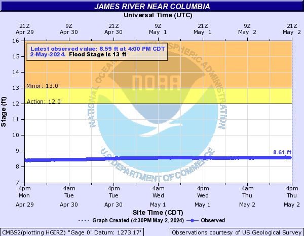
CMBS2:
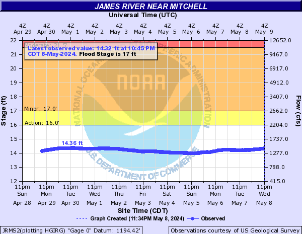
JRMS2:
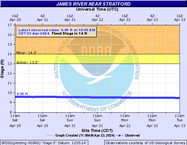
SFDS2:
JMDN8:

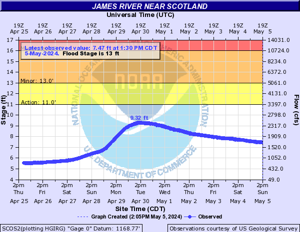
SCOS2:
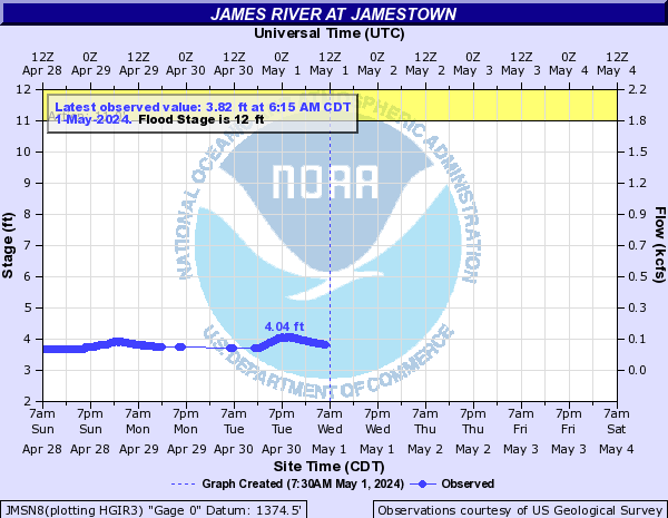
JMSN8:
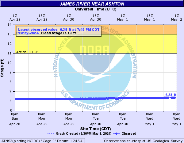
ATNS2:
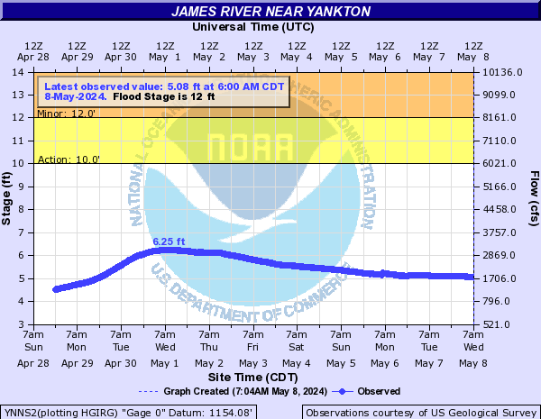
YNNS2:
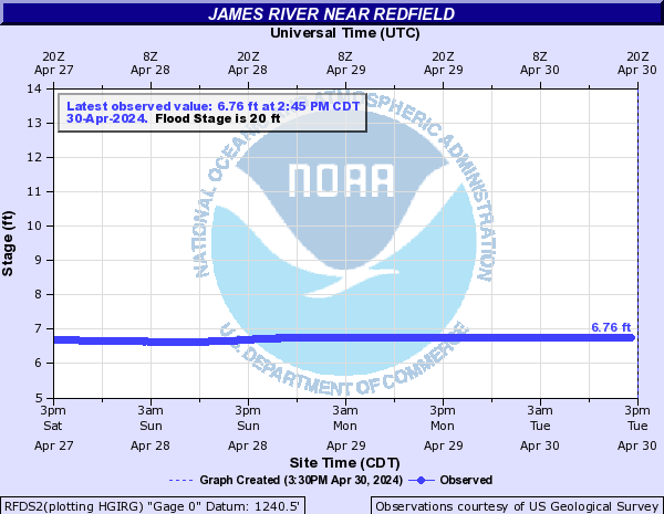
RFDS2:
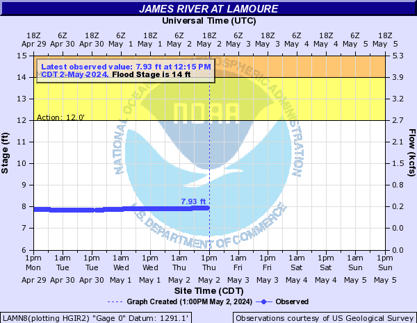
LAMN8:
Jordan Creek (Central IA) (Click on an image to go to hydrograph webpage)
JDAI4:

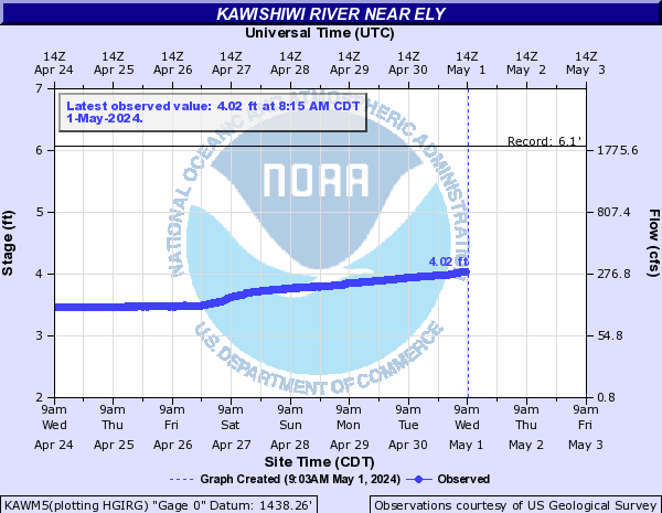
Kawishiwi River (Click on an image to go to hydrograph webpage)
KAWM5:
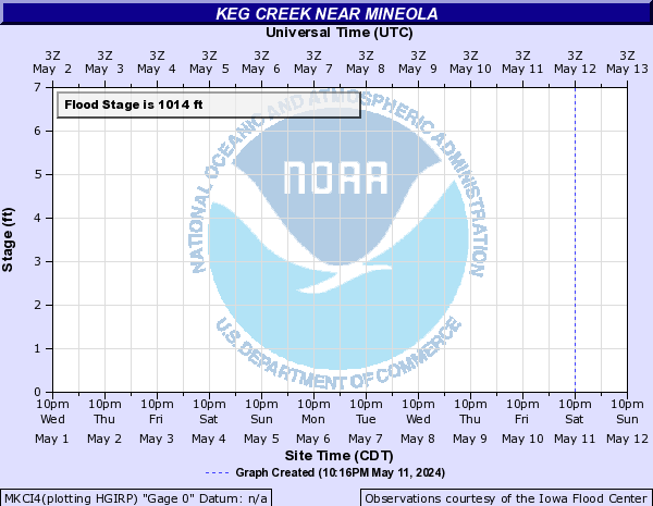
Keg Creek (Click on an image to go to hydrograph webpage)
MKCI4:
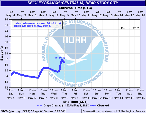
Keigley Branch (Central IA) (Click on an image to go to hydrograph webpage)
STCI4:
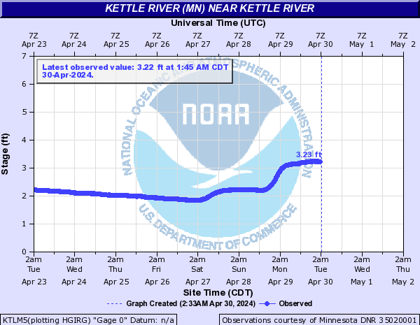
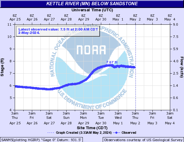
Kettle River (MN) (Click on an image to go to hydrograph webpage)
KTLM5:
SANM5:
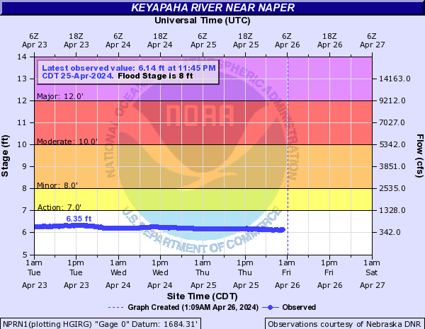
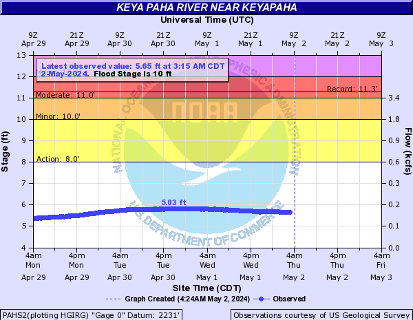
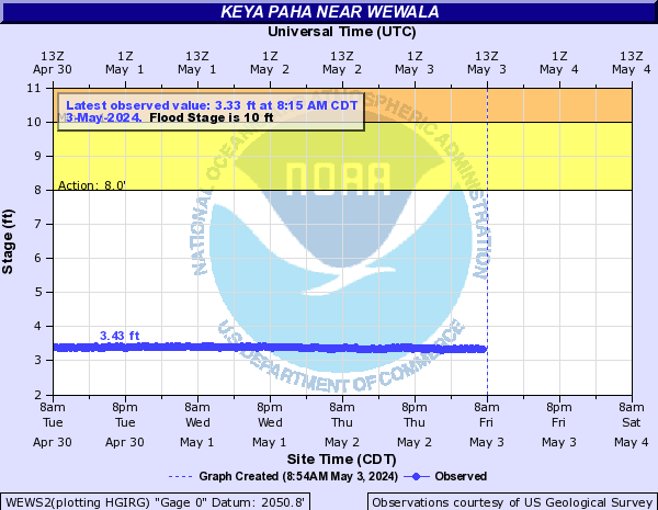
Keyapaha River (Click on an image to go to hydrograph webpage)
NPRN1:
PAHS2:
WEWS2:
Kinnickinnic River (Click on an image to go to hydrograph webpage)
RFSW3:

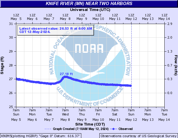
Knife River (MN) (Click on an image to go to hydrograph webpage)
KNIM5:
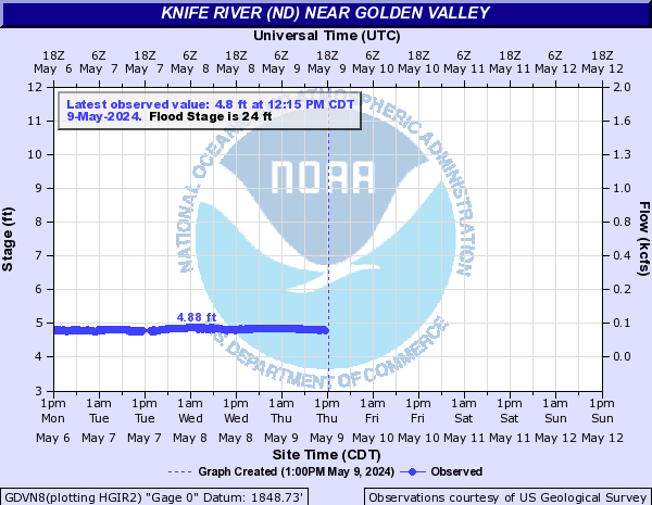
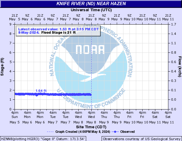
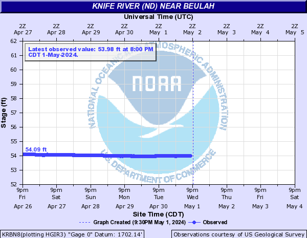
Knife River (ND) (Click on an image to go to hydrograph webpage)
MNGN8:

GDVN8:
HZNN8:
KRBN8:
Knight Creek (Click on an image to go to hydrograph webpage)
OAHN1:

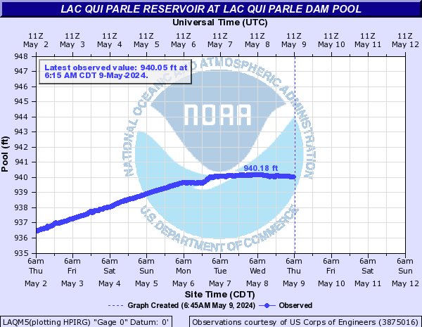
Lac Qui Parle Reservoir (Click on an image to go to hydrograph webpage)
LAQM5:
MILM5:

Lac Qui Parle River (Click on an image to go to hydrograph webpage)
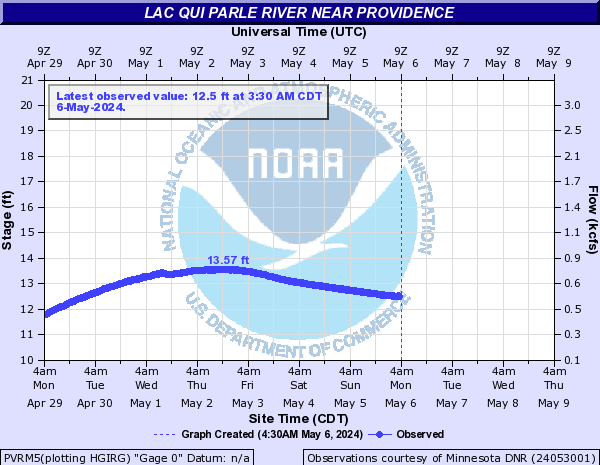
PVRM5:
LQPM5:

Lake Ashtabula (Click on an image to go to hydrograph webpage)
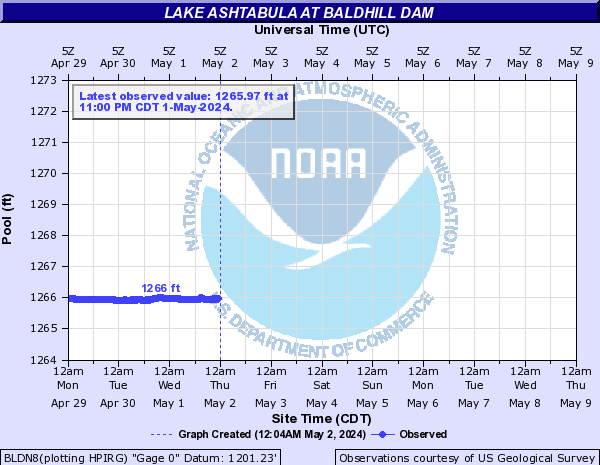
BLDN8:
Lake Creek (SD) (Click on an image to go to hydrograph webpage)
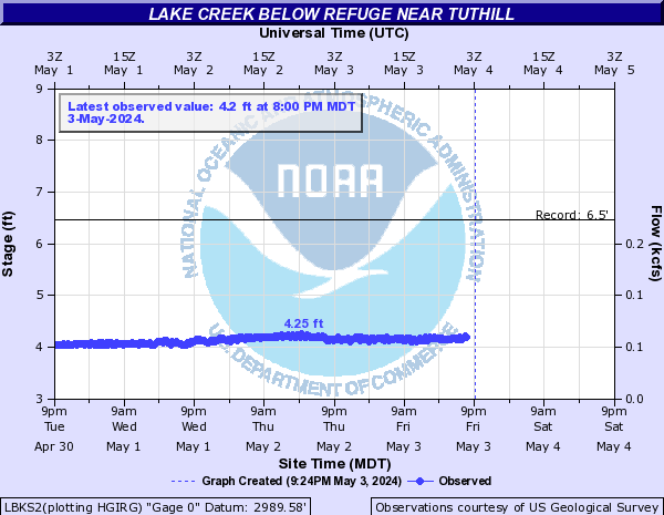
LBKS2:
Lake Kampeska (Click on an image to go to hydrograph webpage)
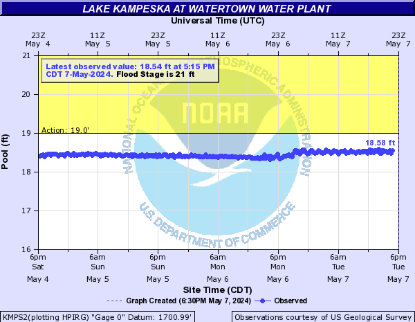
KMPS2:
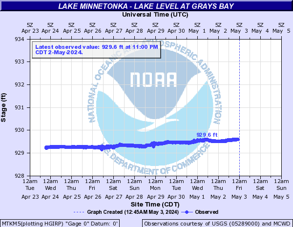
Lake Minnetonka (Click on an image to go to hydrograph webpage)
MTKM5:
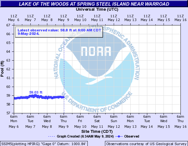
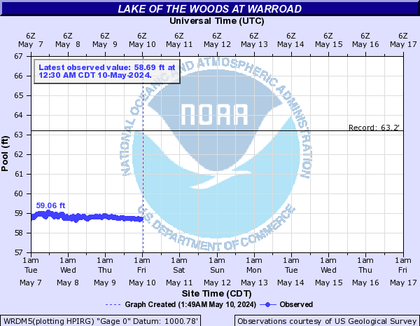
Lake of the Woods (Click on an image to go to hydrograph webpage)
SSIM5:
WRDM5:
Lake Panorama (Central IA) (Click on an image to go to hydrograph webpage)
PNLI4:

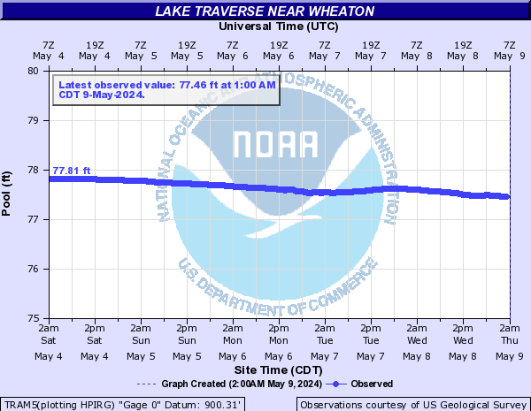
Lake Traverse (Click on an image to go to hydrograph webpage)
TRAM5:
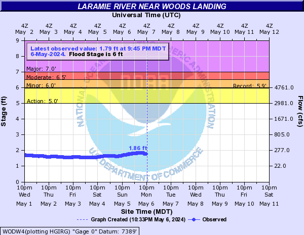
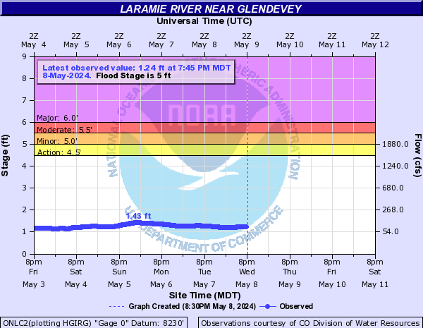
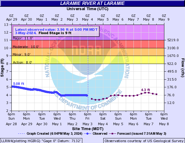
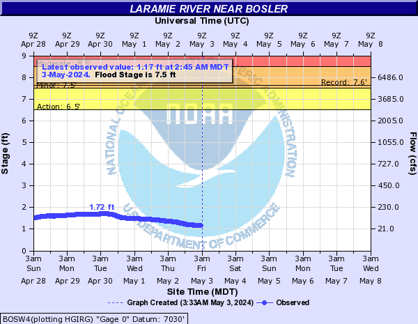
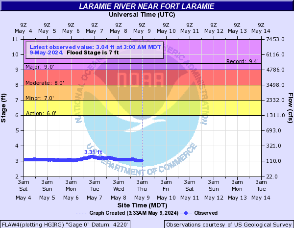
Laramie River (Click on an image to go to hydrograph webpage)
WODW4:
ONLC2:
LLRW4:
BOSW4:
FLAW4:
WTRW4:
Lateral 1 (Click on an image to go to hydrograph webpage)
TRDM5:
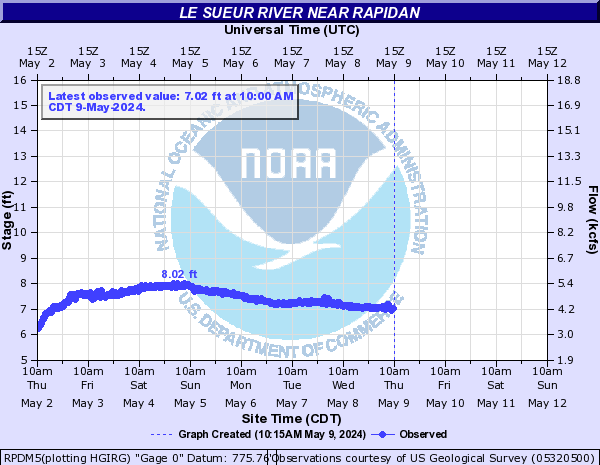
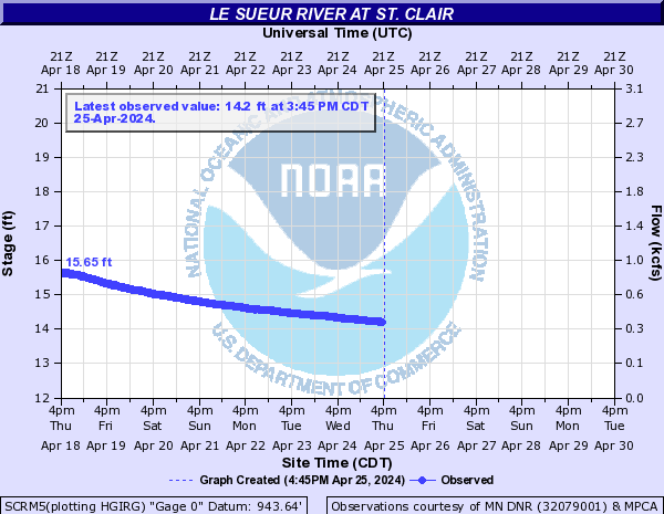
Le Sueur River (Click on an image to go to hydrograph webpage)
RPDM5:
SCRM5:
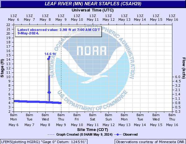
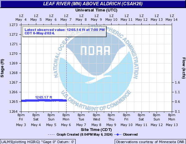
Leaf River (MN) (Click on an image to go to hydrograph webpage)
LFEM5:
LALM5:
Leavenworth Creek (CO) (Click on an image to go to hydrograph webpage)
LVMC2:

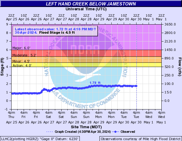
Left Hand Creek (CO) (Click on an image to go to hydrograph webpage)
LLHC2:
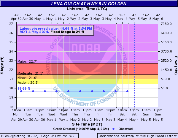
Lena Gulch (CO) (Click on an image to go to hydrograph webpage)
HIWC2:
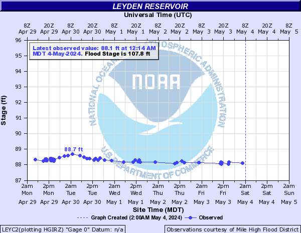
Leyden Creek (CO) (Click on an image to go to hydrograph webpage)
LEYC2:
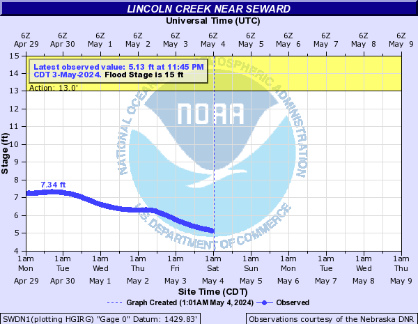
Lincoln Creek (Click on an image to go to hydrograph webpage)
SWDN1:
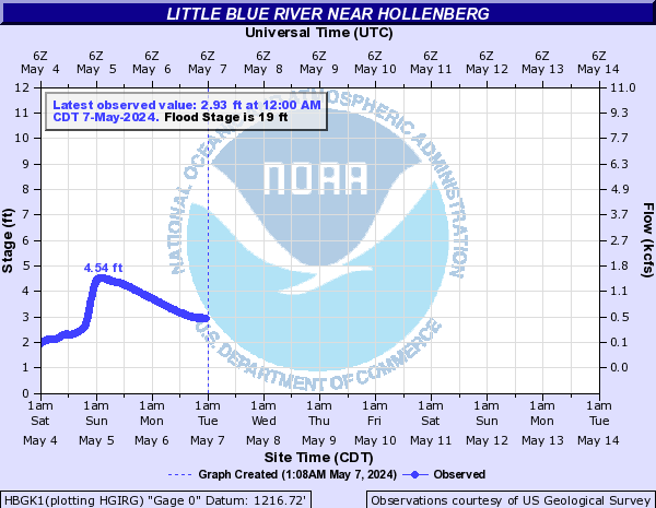
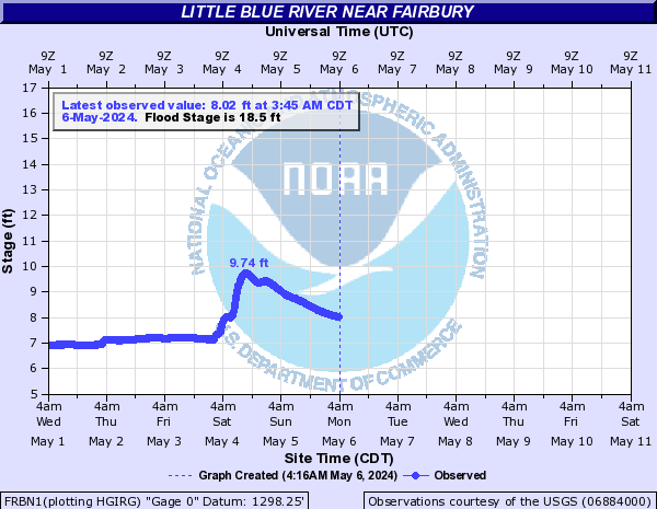
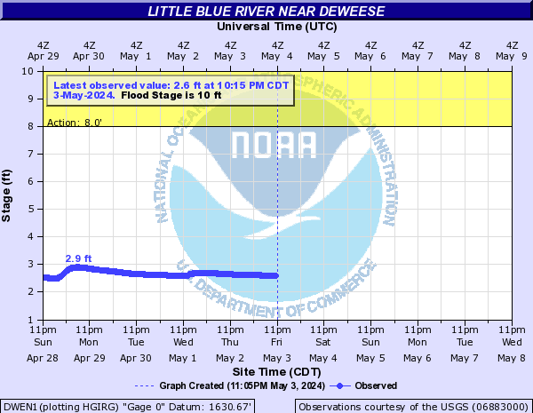
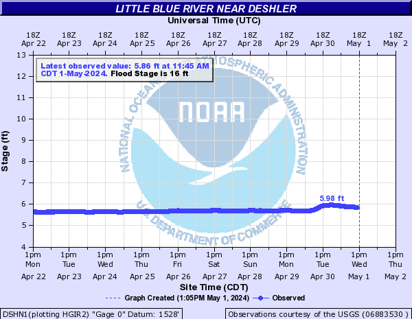
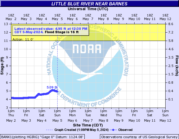
Little Blue River (Click on an image to go to hydrograph webpage)
HBGK1:
FRBN1:
DWEN1:
DSHN1:
BANK1:
HBON1:

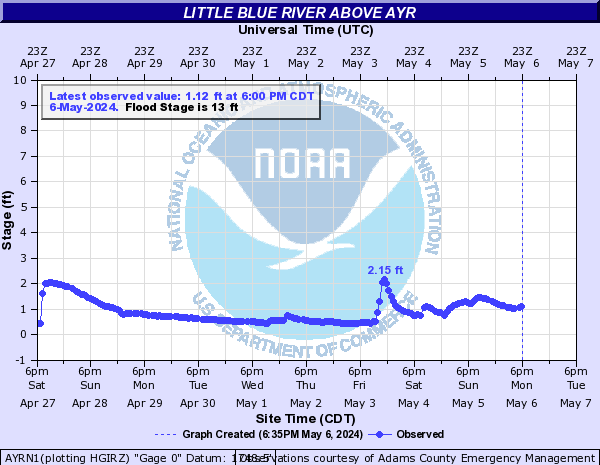
AYRN1:
Little Cannon River (Click on an image to go to hydrograph webpage)
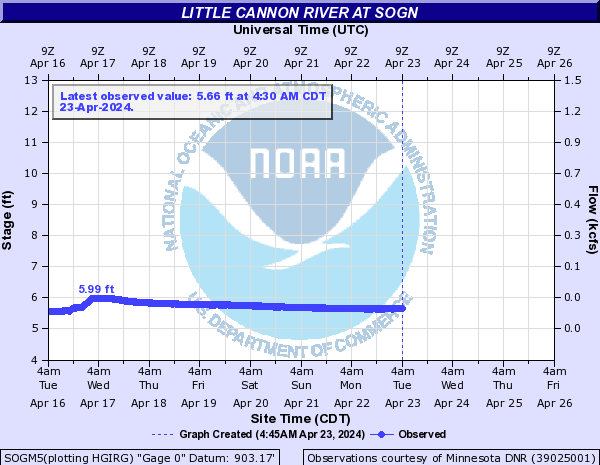
SOGM5:
CNFM5:

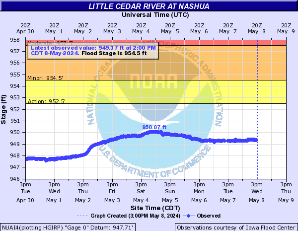
Little Cedar River (Click on an image to go to hydrograph webpage)
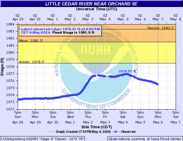
LCOI4:
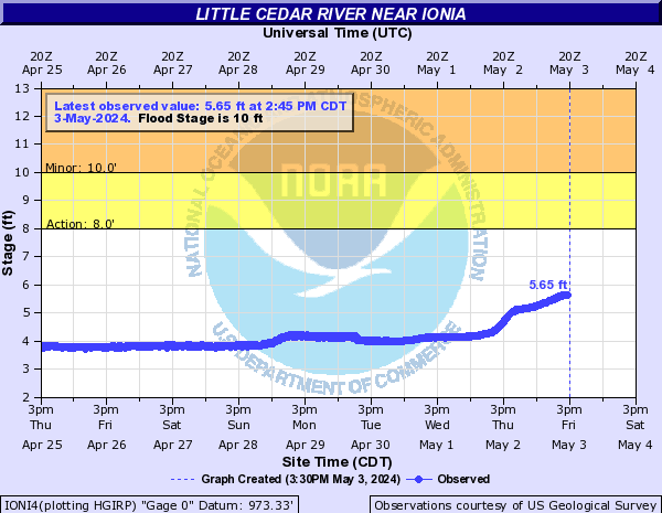
IONI4:
NUAI4:
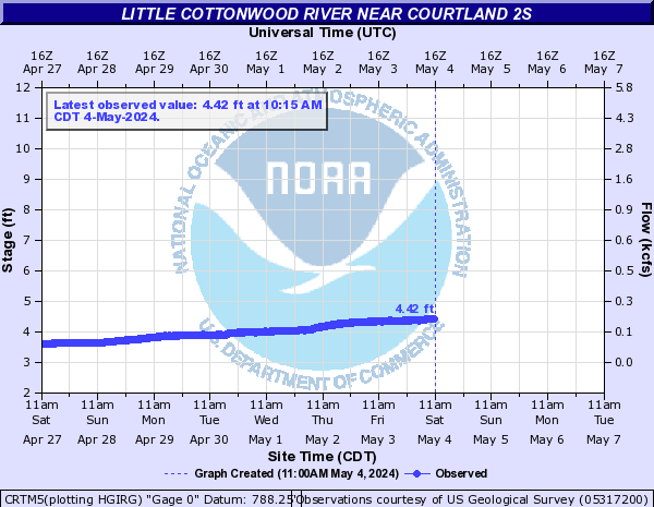
Little Cottonwood River (Click on an image to go to hydrograph webpage)
CRTM5:
Little Floyd River (Click on an image to go to hydrograph webpage)
LFSI4:

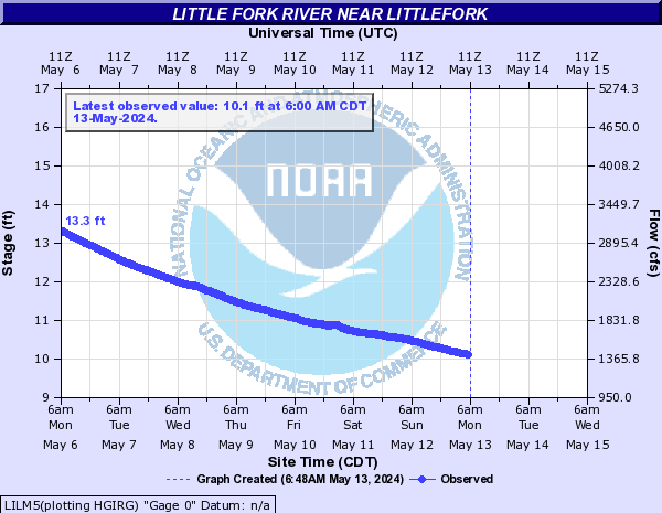
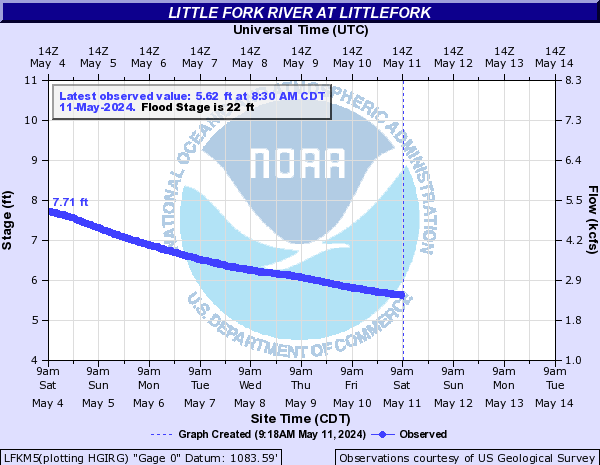
Little Fork River (Click on an image to go to hydrograph webpage)
LDNM5:
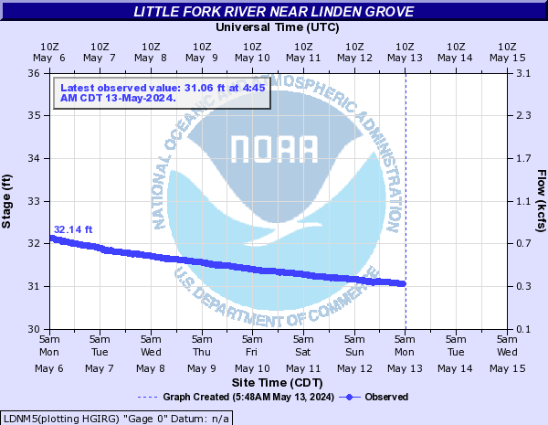
LTLM5:
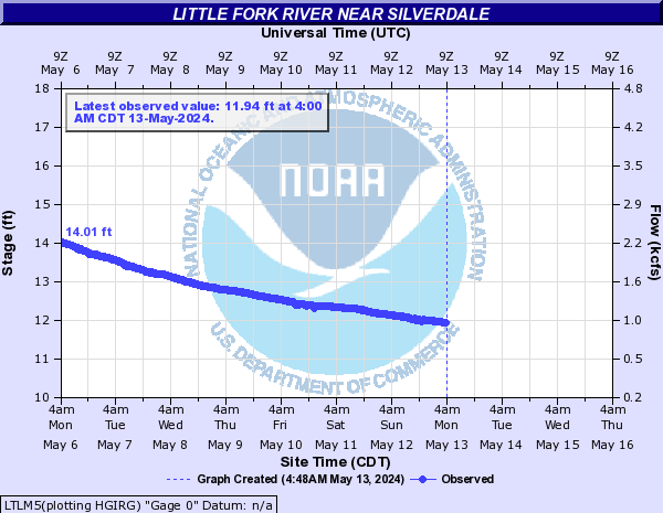
LILM5:
LFKM5:
Little Laramie River (Click on an image to go to hydrograph webpage)
SMTW4:

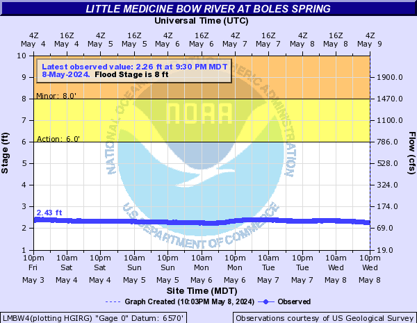
Little Medicine Bow River (Click on an image to go to hydrograph webpage)
LMBW4:
Little Minnesota River (Click on an image to go to hydrograph webpage)
PVRS2:

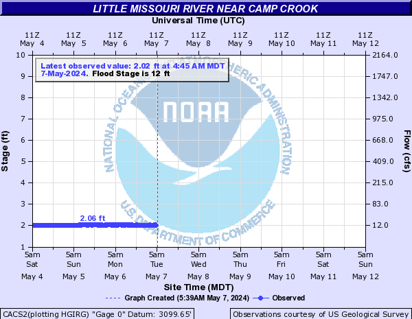
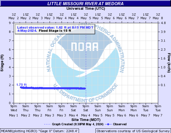
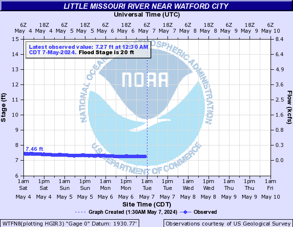
Little Missouri River (Click on an image to go to hydrograph webpage)
CACS2:
MTHN8:

MDAN8:
WTFN8:
Little Muddy River (Click on an image to go to hydrograph webpage)
LMCN8:

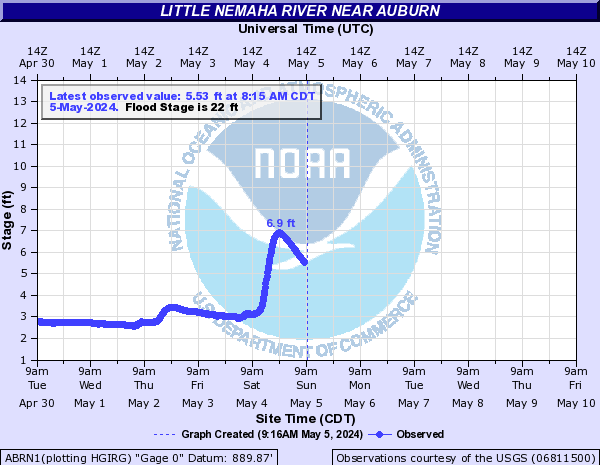
Little Nemaha River (Click on an image to go to hydrograph webpage)
ABRN1:
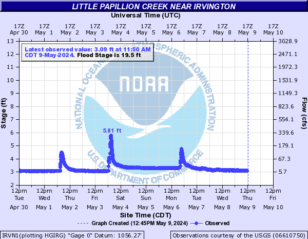
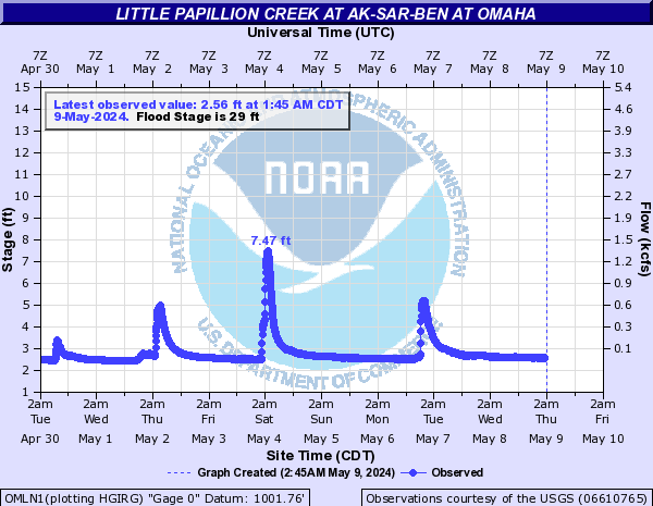
Little Papillion Creek (Click on an image to go to hydrograph webpage)
IRVN1:
OMLN1:
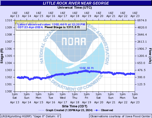
Little Rock River (Click on an image to go to hydrograph webpage)
LRGI4:
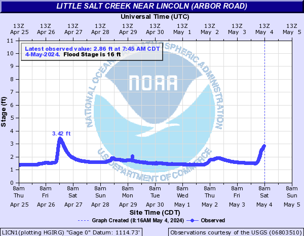
Little Salt Creek (Click on an image to go to hydrograph webpage)
LICN1:
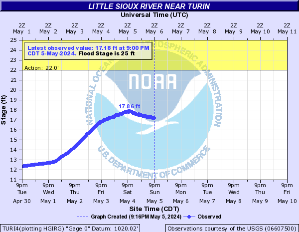
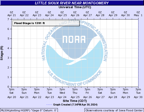
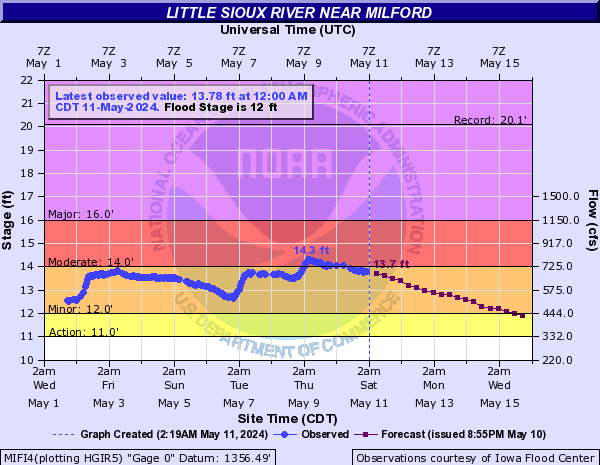
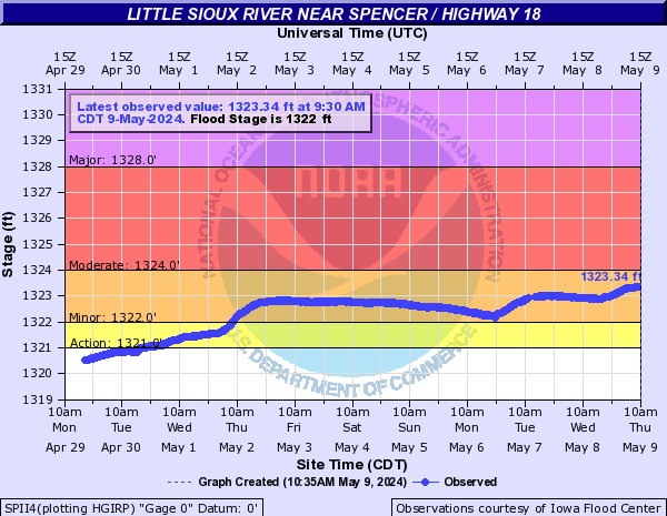
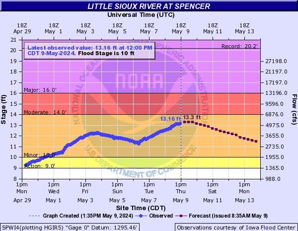
Little Sioux River (Click on an image to go to hydrograph webpage)
TURI4:
MLSI4:
MIFI4:
LSSI4:

SPII4:
SPWI4:
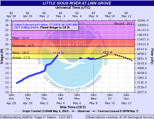
LNNI4:
CHKI4:

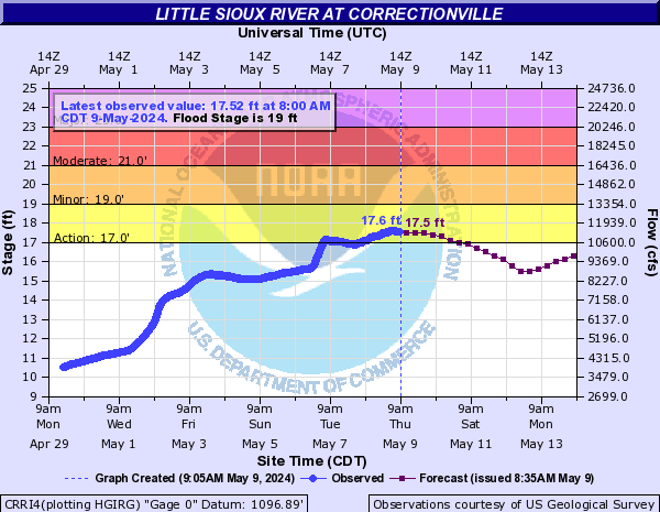
CRRI4:
Little South Pembina River (Click on an image to go to hydrograph webpage)
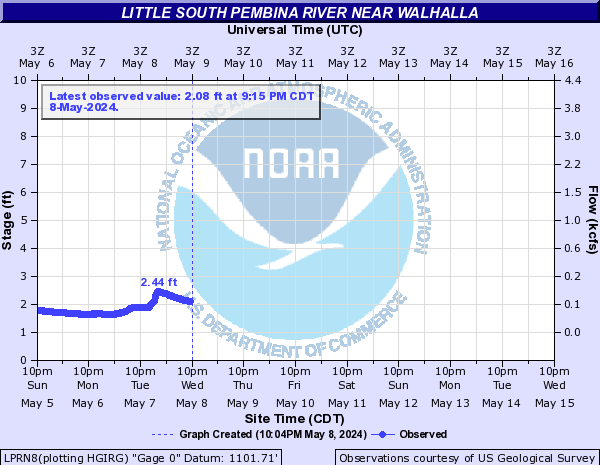
LPRN8:
Little Spearfish Creek (Click on an image to go to hydrograph webpage)
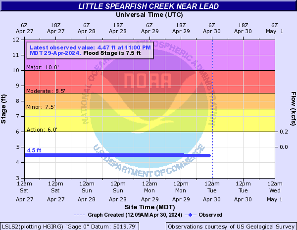
LSLS2:
Little Vermillion River (Click on an image to go to hydrograph webpage)
LVSS2:

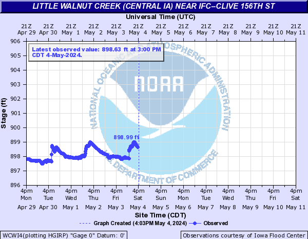
Little Walnut Creek (Central IA) (Click on an image to go to hydrograph webpage)
WCWI4:
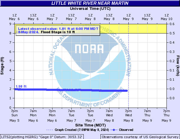
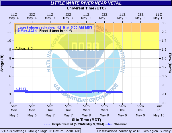
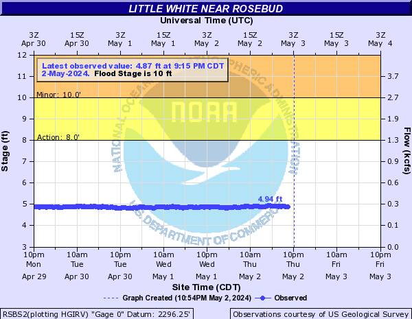
Little White River (Click on an image to go to hydrograph webpage)
LITS2:
VTLS2:
RSBS2:
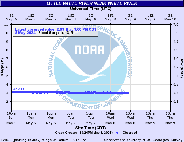
LWRS2:
Lizard Creek (Northern IA) (Click on an image to go to hydrograph webpage)
FLZI4:

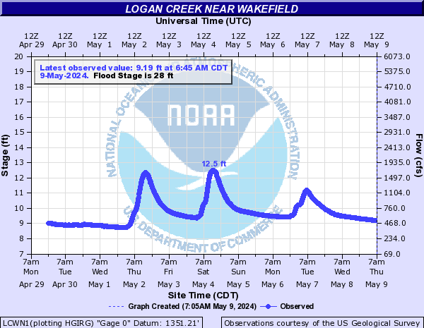
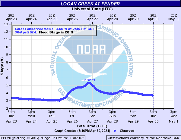
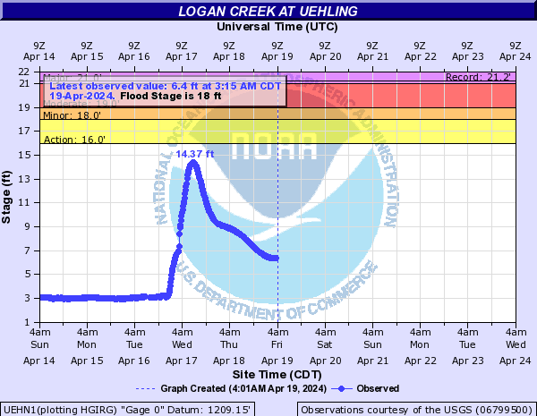
Logan Creek (Click on an image to go to hydrograph webpage)
LCWN1:
PEDN1:
UEHN1:
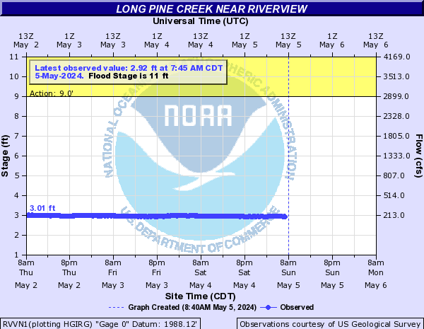
Long Pine Creek (Click on an image to go to hydrograph webpage)
RVVN1:
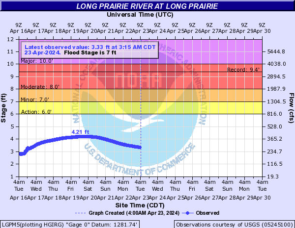
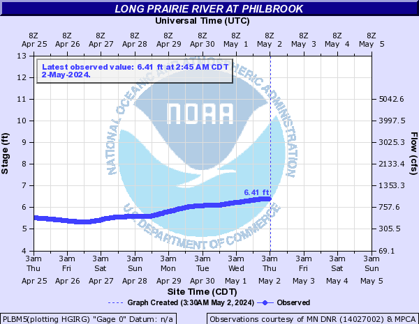
Long Prairie River (Click on an image to go to hydrograph webpage)
LGPM5:
PLBM5:
Loon Creek (Click on an image to go to hydrograph webpage)
LCKM5:

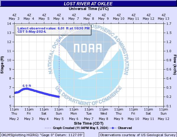
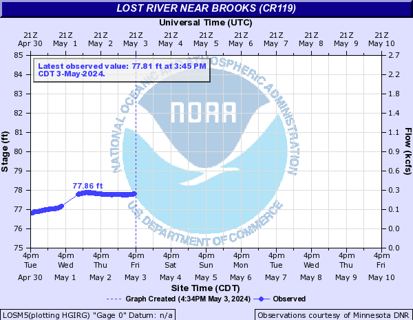
Lost River (Click on an image to go to hydrograph webpage)
OKLM5:
LOSM5:
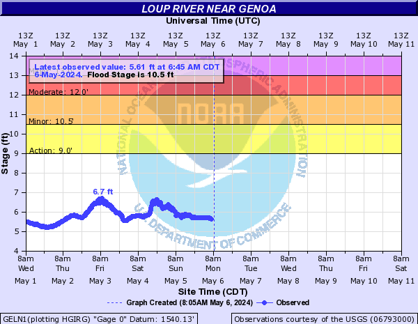
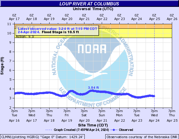
Loup River (Click on an image to go to hydrograph webpage)
GELN1:
CLMN1:
Loup River Power Canal (Click on an image to go to hydrograph webpage)
CLSN1:
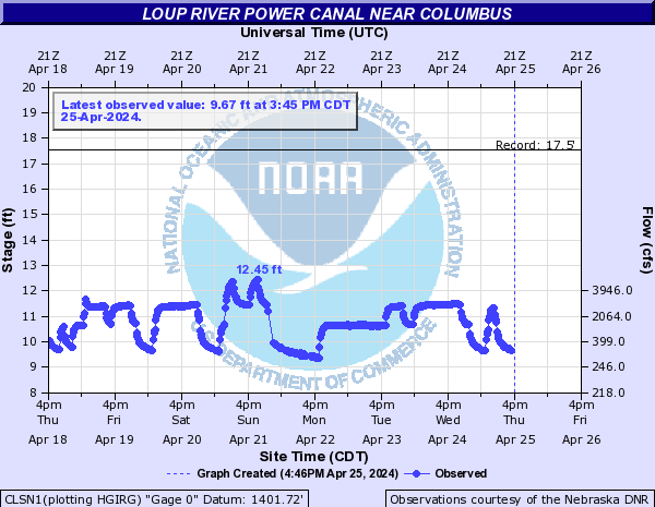
GEAN1:

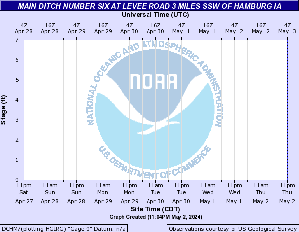
Main Ditch Number Six (Click on an image to go to hydrograph webpage)
DCHM7:
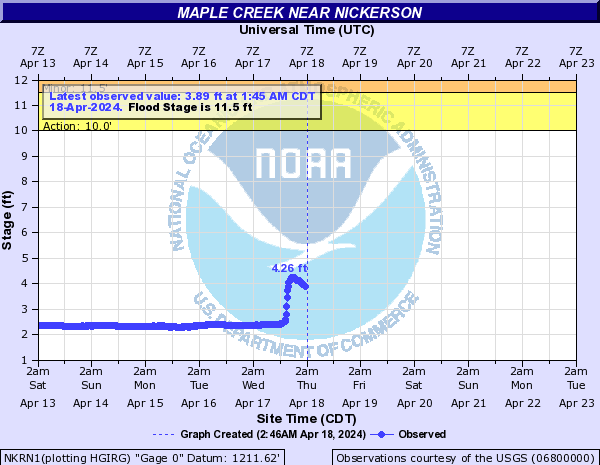
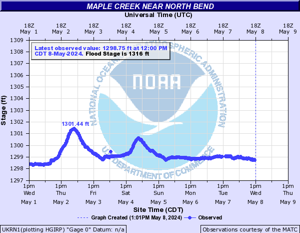
Maple Creek (Click on an image to go to hydrograph webpage)
NKRN1:
UKRN1:
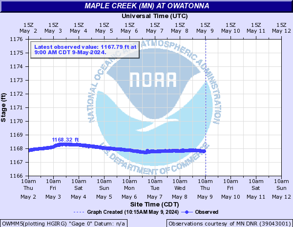
Maple Creek (MN) (Click on an image to go to hydrograph webpage)
OWMM5:
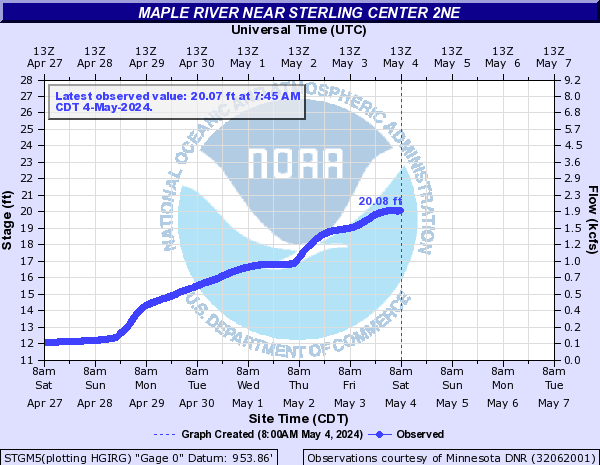
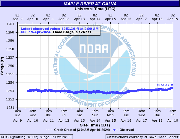
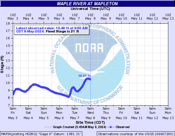
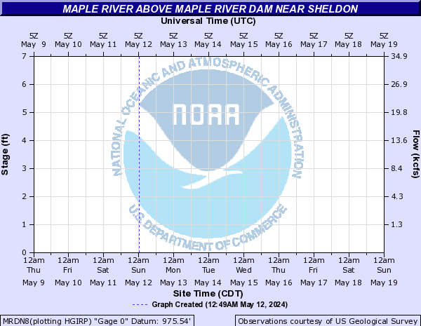
Maple River (Click on an image to go to hydrograph webpage)
STGM5:
MRGI4:
MAPI4:
MAPS2:
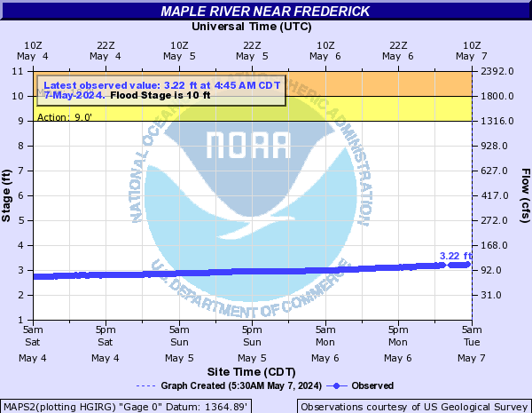
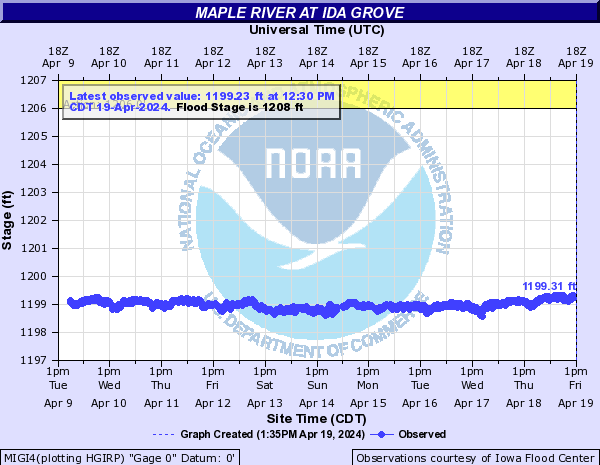
MIGI4:
Maple River (ND) (Click on an image to go to hydrograph webpage)
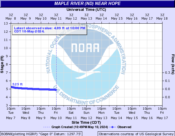
BOBN8:
ENDN8:

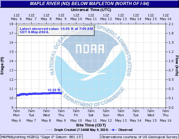
MAPN8:
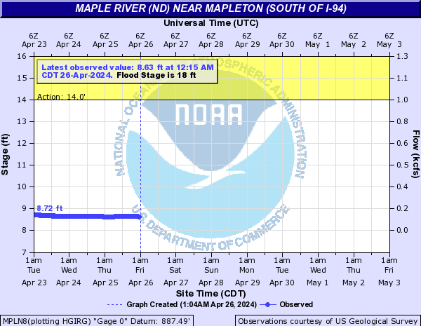
MPLN8:
MRDN8:
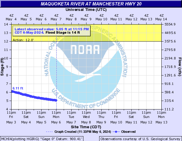
Maquoketa River (Click on an image to go to hydrograph webpage)
MCHI4:
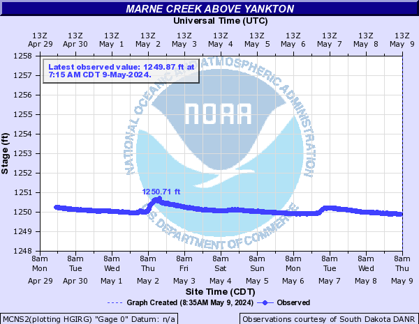
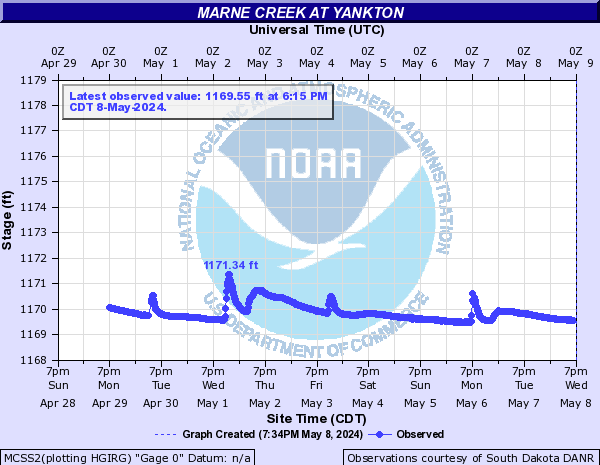
Marne Creek (Click on an image to go to hydrograph webpage)
MCNS2:
MCSS2:
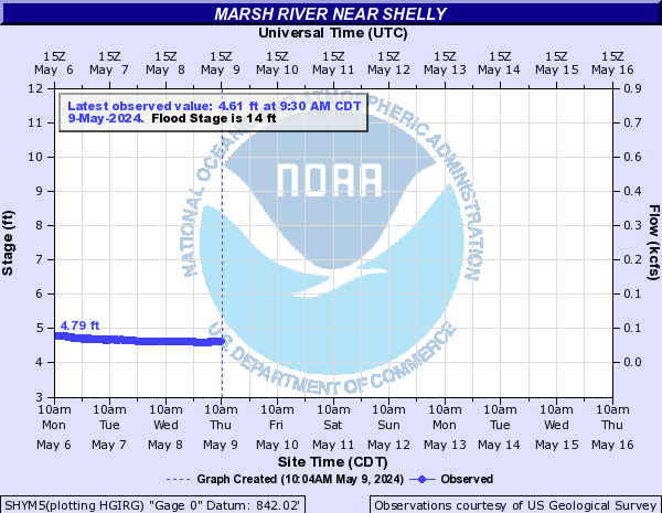
Marsh River (Click on an image to go to hydrograph webpage)
SHYM5:
Medary Creek (Click on an image to go to hydrograph webpage)
MDYS2:

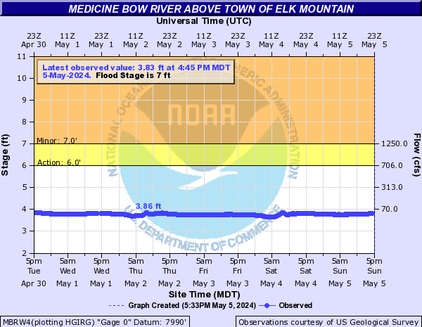
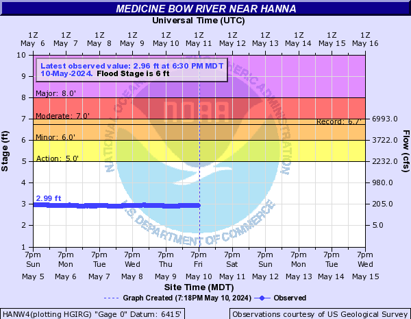
Medicine Bow River (Click on an image to go to hydrograph webpage)
MBRW4:
HANW4:
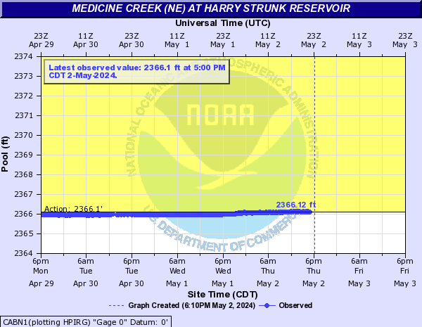
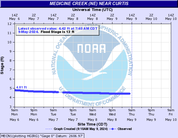
Medicine Creek (NE) (Click on an image to go to hydrograph webpage)
CABN1:
SOMN1:
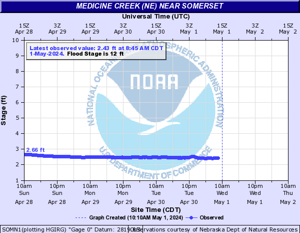
MECN1:
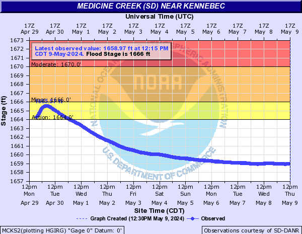
Medicine Creek (SD) (Click on an image to go to hydrograph webpage)
MCKS2:
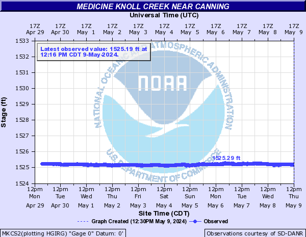
Medicine Knoll Creek (Click on an image to go to hydrograph webpage)
MKCS2:
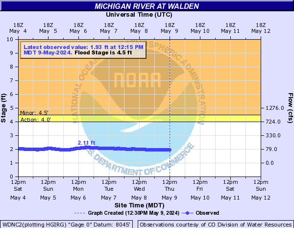
Michigan River (CO) (Click on an image to go to hydrograph webpage)
WDNC2:
Middle Boulder Creek (CO) (Click on an image to go to hydrograph webpage)
MBNC2:

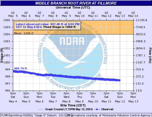
Middle Branch Root River (Click on an image to go to hydrograph webpage)
FLMM5:
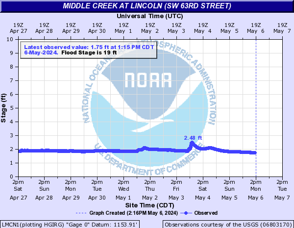
Middle Creek (Click on an image to go to hydrograph webpage)
LMCN1:
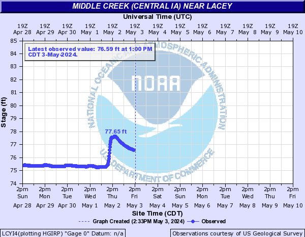
Middle Creek (Central IA) (Click on an image to go to hydrograph webpage)
LCYI4:
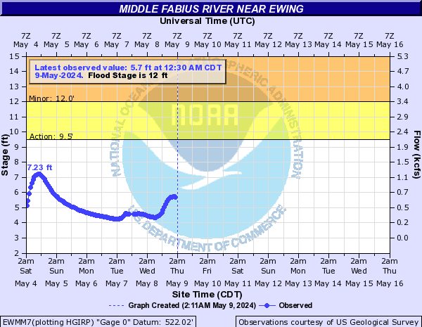
Middle Fabius River (Click on an image to go to hydrograph webpage)
EWMM7:
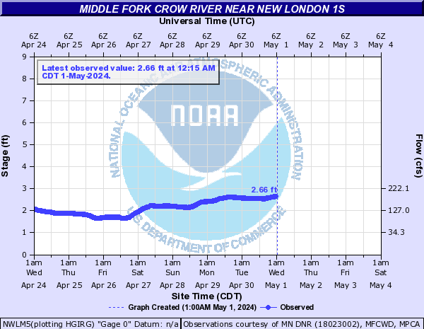
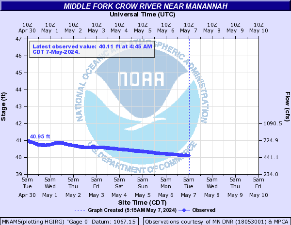
Middle Fork Crow River (Click on an image to go to hydrograph webpage)
NWLM5:
SPCM5:
MNAM5:
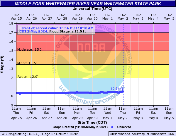
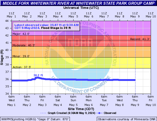
Middle Fork Whitewater River (Click on an image to go to hydrograph webpage)
WSPM5:
WWPM5:
Middle Fork Zumbro River (Click on an image to go to hydrograph webpage)
PNLM5:
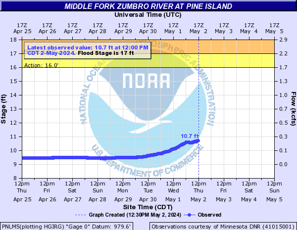
BNEM5:

Middle Loup River (Click on an image to go to hydrograph webpage)
SPLN1:
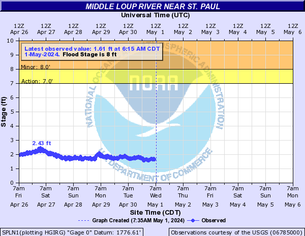
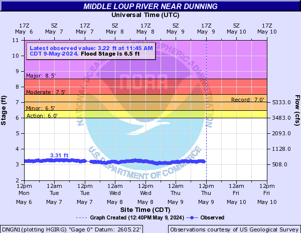
DNGN1:
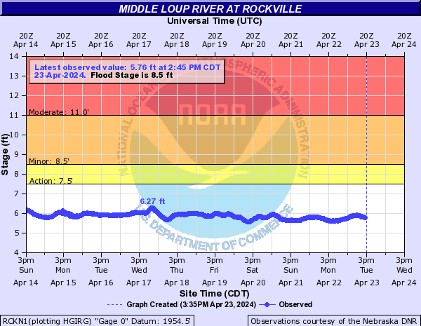
RCKN1:
Middle Raccoon River (IA) (Click on an image to go to hydrograph webpage)
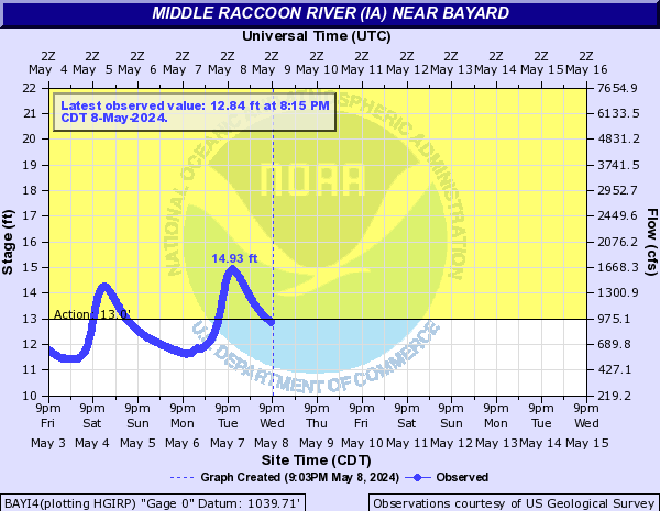
BAYI4:
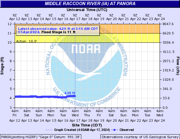
PANI4:
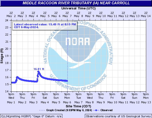
Middle Raccoon River Tributary (IA) (Click on an image to go to hydrograph webpage)
CLLI4:
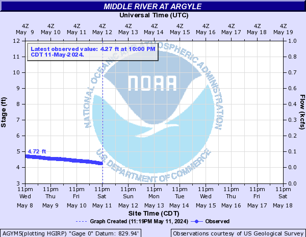
Middle River (Click on an image to go to hydrograph webpage)
AGYM5:
Middle River (Central IA) (Click on an image to go to hydrograph webpage)
IDNI4:

Milford Creek (Click on an image to go to hydrograph webpage)
OBJI4:
LGLI4:
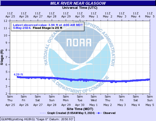
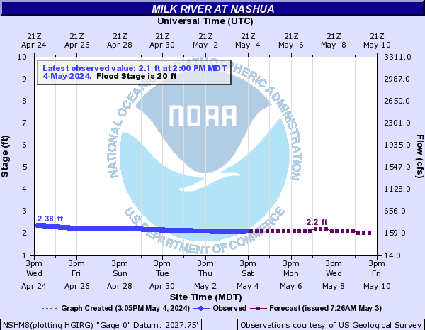
Milk River (Click on an image to go to hydrograph webpage)
GLWM8:
NSHM8:
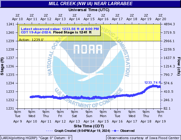
Mill Creek (NW IA) (Click on an image to go to hydrograph webpage)
LARI4:
Mill Creek (WSHK1) (Click on an image to go to hydrograph webpage)
WSHK1:

Mille Lacs Lake (Click on an image to go to hydrograph webpage)
MLLM5:

Minnehaha Creek (Click on an image to go to hydrograph webpage)
MHAM5:

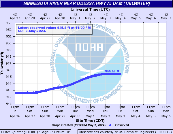
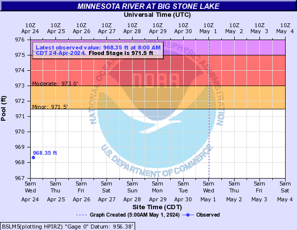
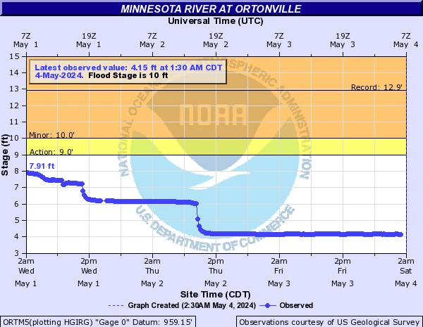
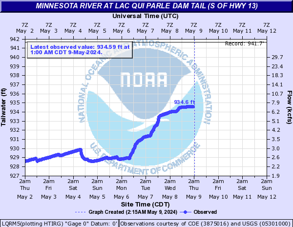
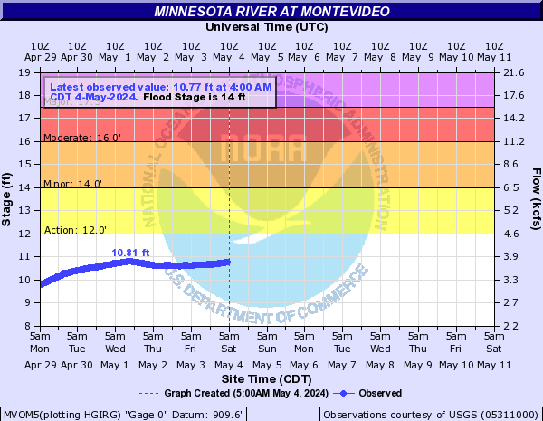
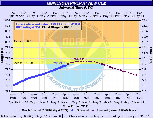
Minnesota River (Click on an image to go to hydrograph webpage)
ODAM5:
BSLM5:
MLDM5:

ORTM5:
LQRM5:
MVOM5:
GTEM5:

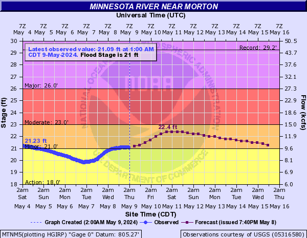
MTNM5:
NULM5:
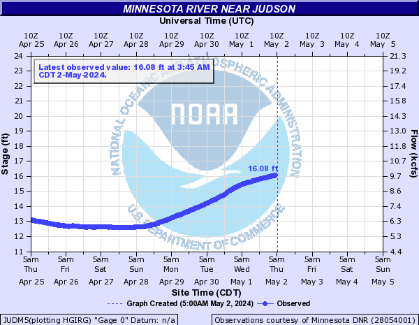
JUDM5:
MNKM5:

SPTM5:

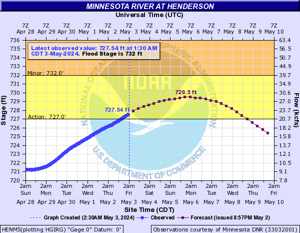
HENM5:
JDNM5:

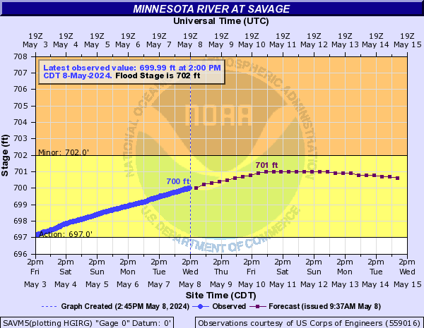
SAVM5:
Mira Creek (Click on an image to go to hydrograph webpage)
NLPN1:

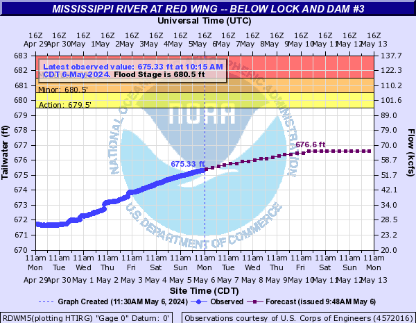
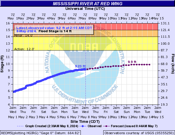
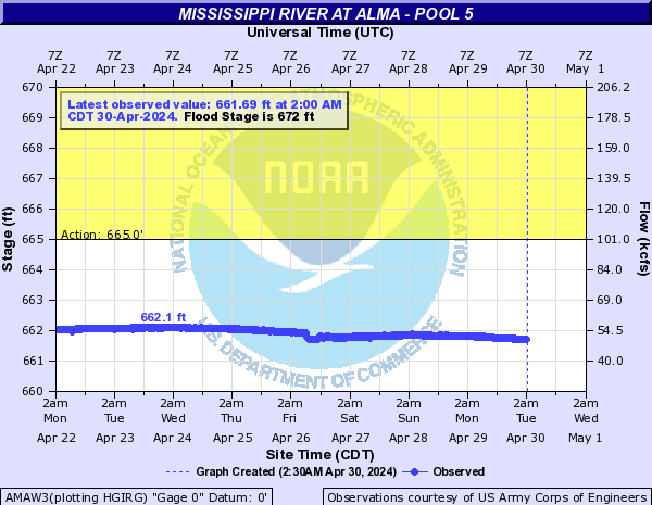
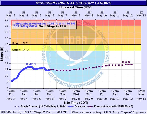
Mississippi River (Click on an image to go to hydrograph webpage)
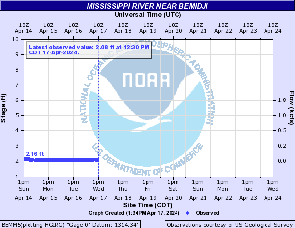
BEMM5:
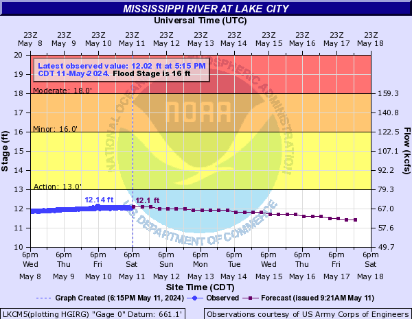
LKCM5:
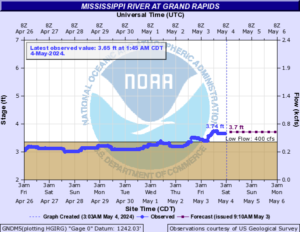
GNDM5:
BLHM5:

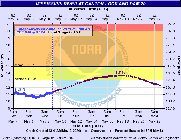
CANM7:
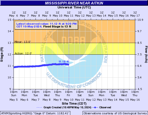
ATKM5:
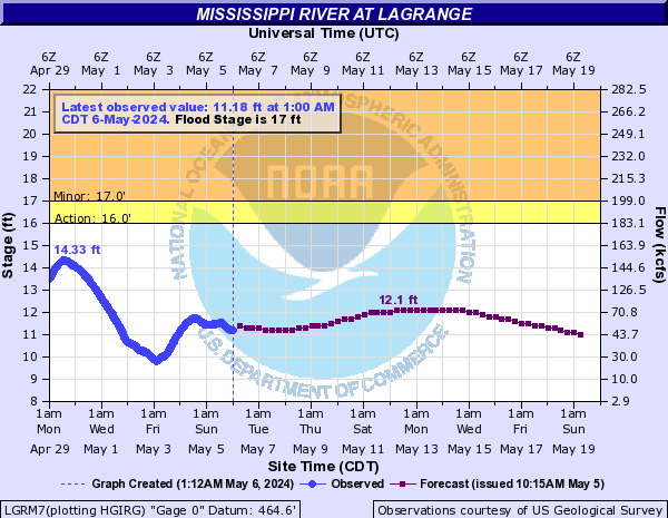
LGRM7:
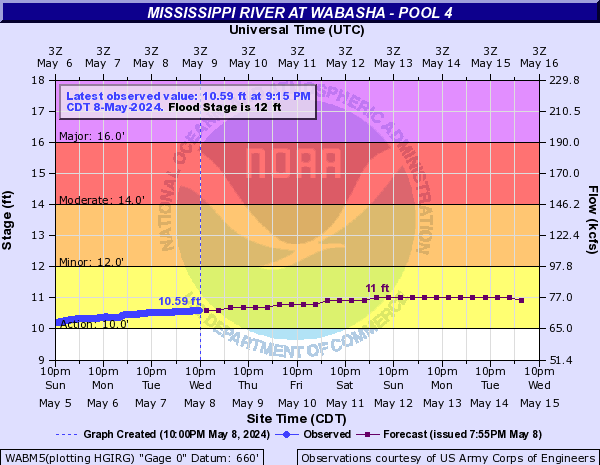
WABM5:
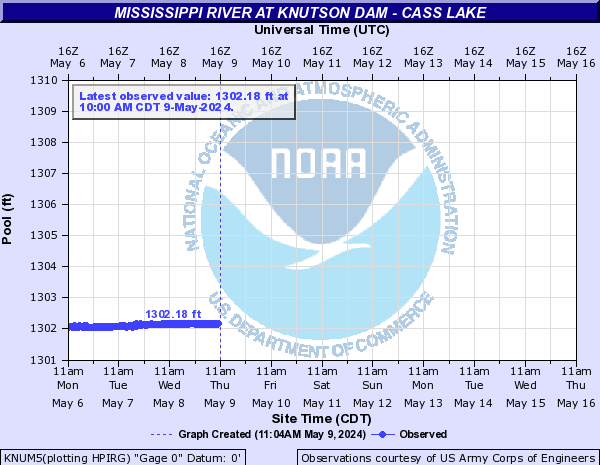
KNUM5:
SCOM5:

AKAM5:
MSWM5:
ALMW3:
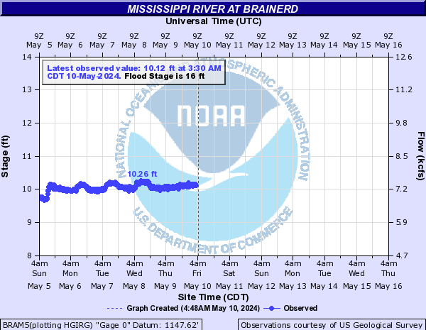
BRAM5:
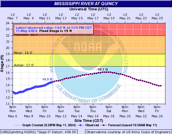
UINI2:
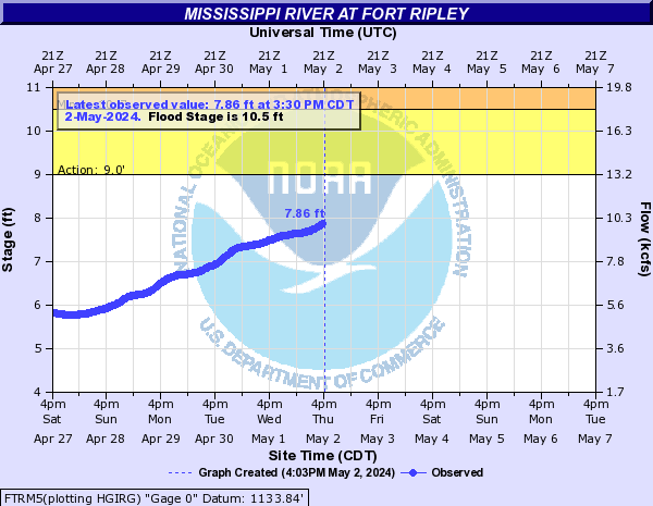
FTRM5:
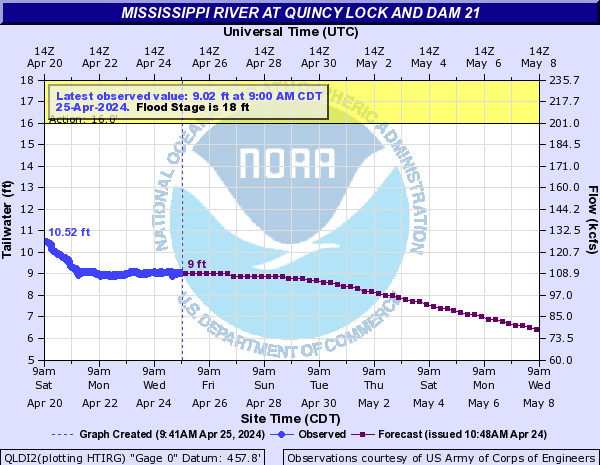
QLDI2:
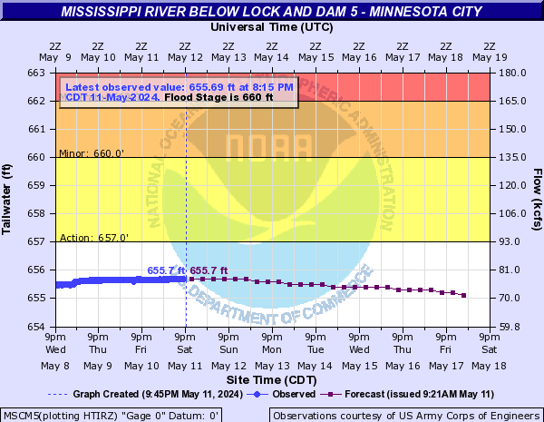
MSCM5:
ANKM5:
WIDM5:

MSPM5:
STPM5:
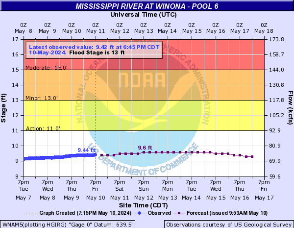
WNAM5:
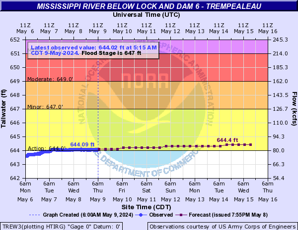
TREW3:
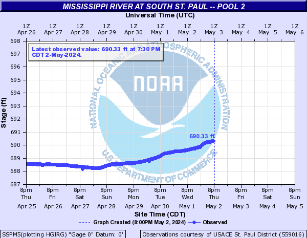
SSPM5:
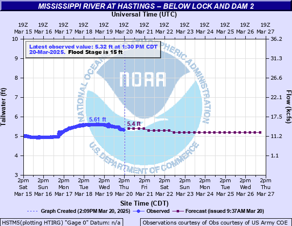
HSTM5:
PREW3:

RDWM5:
REDM5:
AMAW3:
GGYM7:
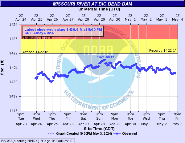
Missouri River (Click on an image to go to hydrograph webpage)
SJSM7:

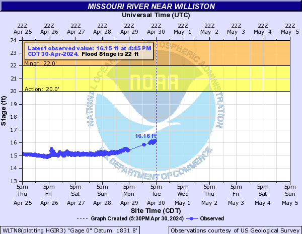
WLTN8:
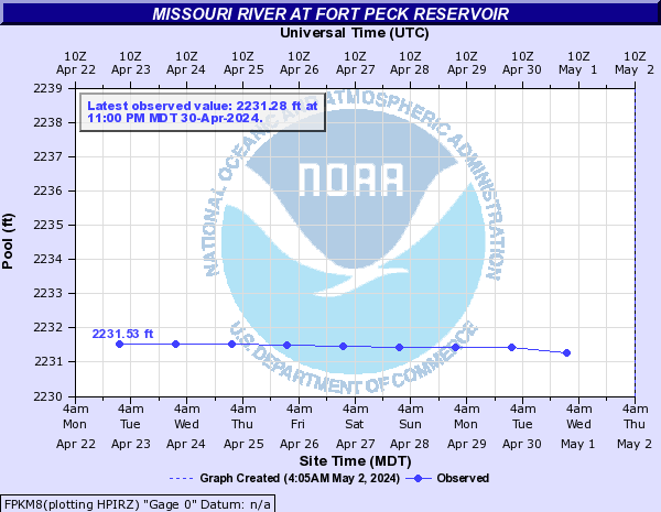
FPKM8:
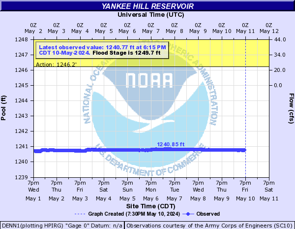
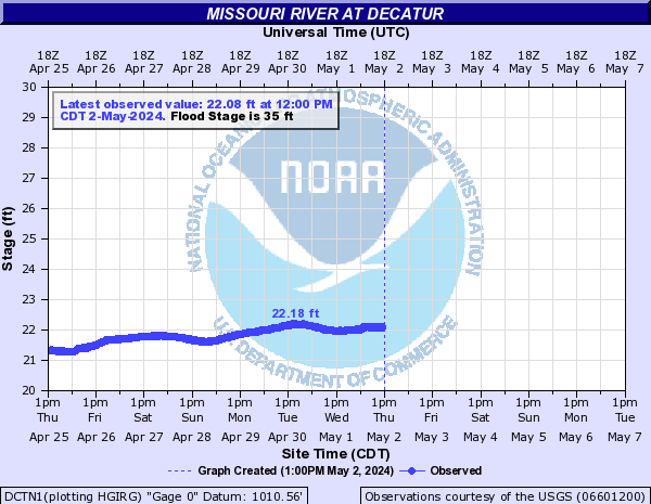
DCTN1:
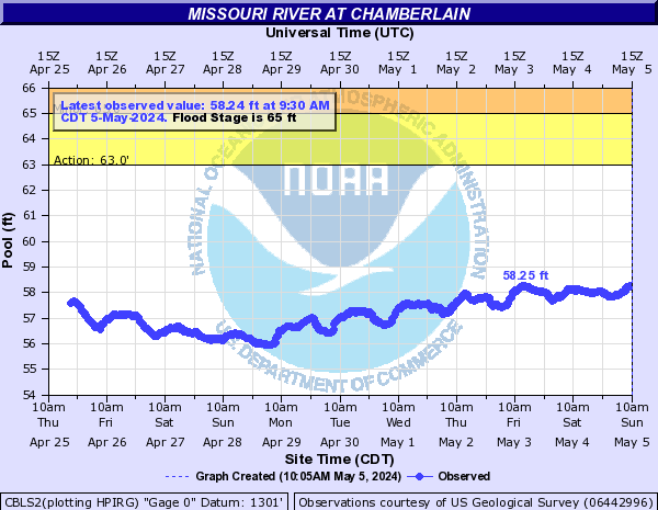
CBLS2:
PIES2:

BLAN1:
GARN8:
PIRS2:
WPTM8:

FRDS2:
ATCK1:

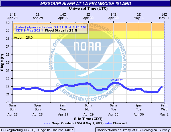
LFIS2:
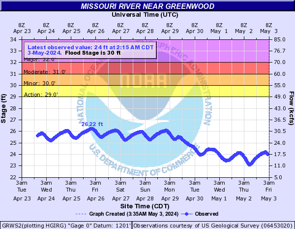
GRWS2:
BIWN8:

CLBM8:
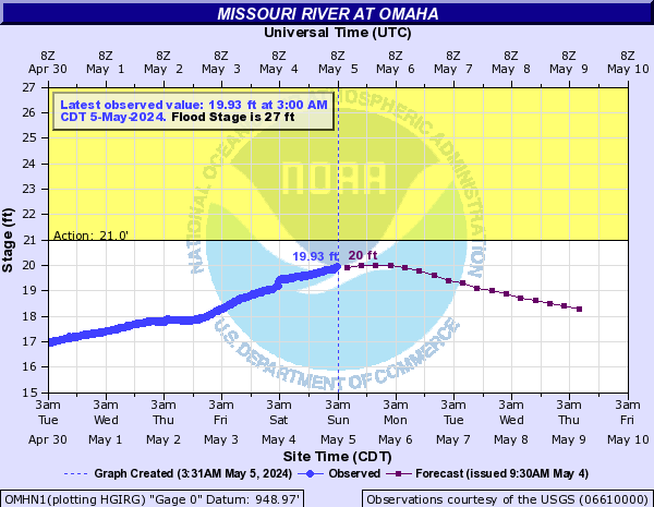
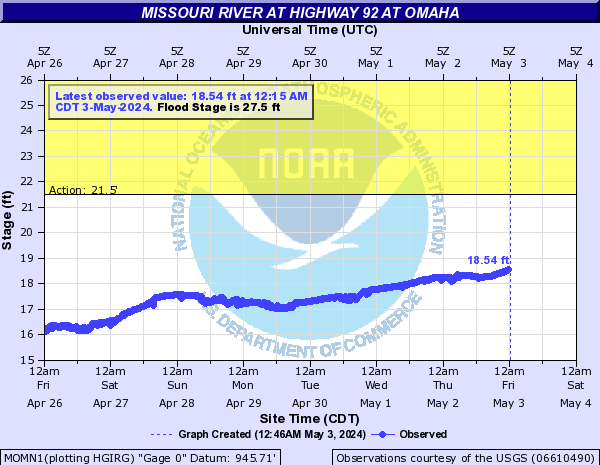
OMHN1:
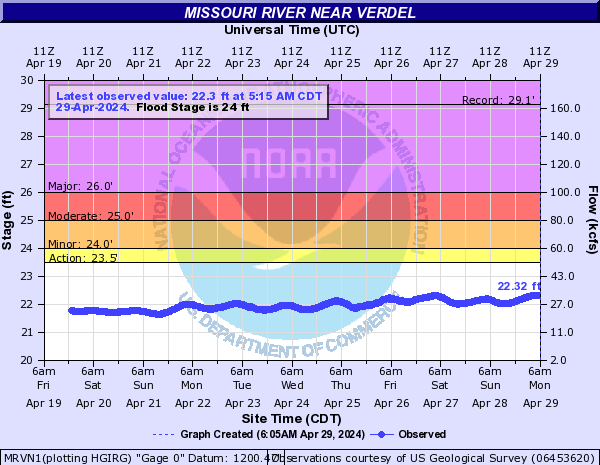
MRVN1:
MOMN1:
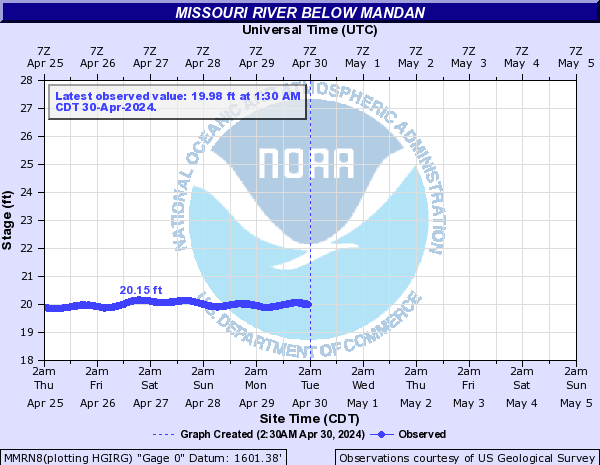
MMRN8:
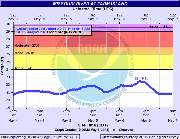
FRMS2:
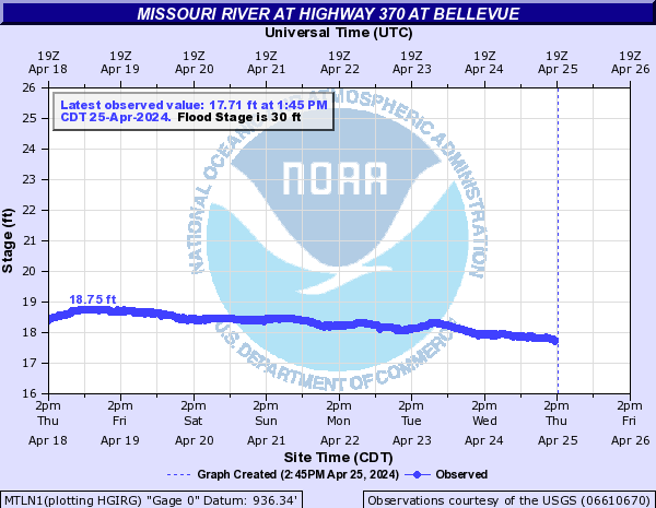
MTLN1:
BBDS2:
MRNN1:
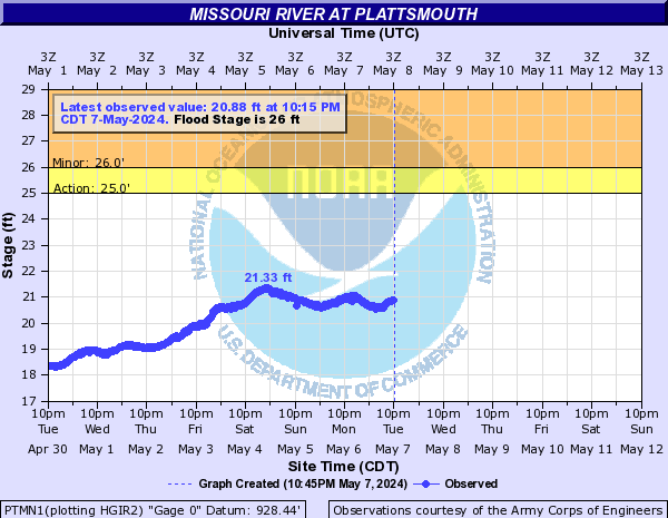
PTMN1:
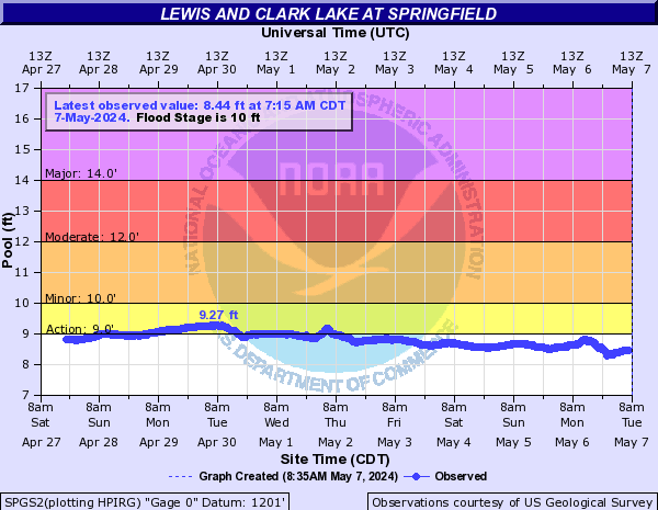
SPGS2:
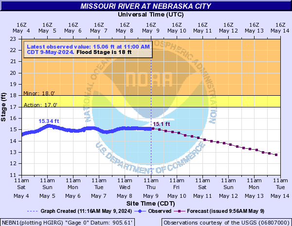
NEBN1:
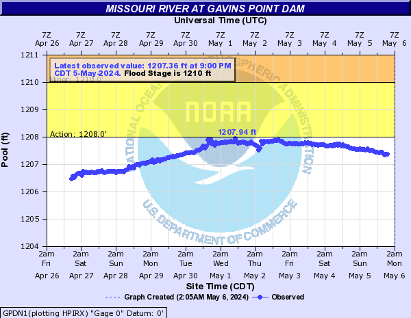
GPDN1:
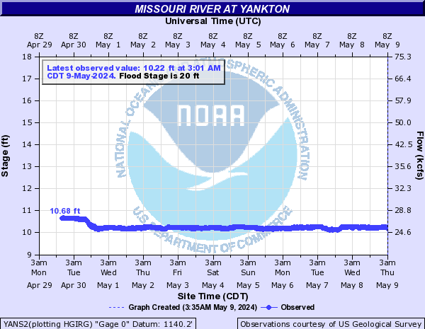
YANS2:
BRON1:

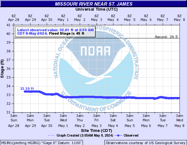
MSJN1:
RULN1:

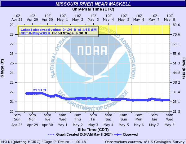
MKLN1:
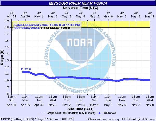
MRPN1:
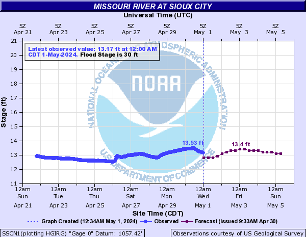
SSCN1:
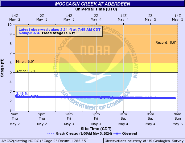
Moccasin Creek (Click on an image to go to hydrograph webpage)
AMCS2:
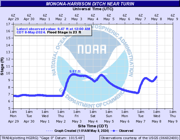
Monona-Harrison Ditch (Click on an image to go to hydrograph webpage)
TRNI4:
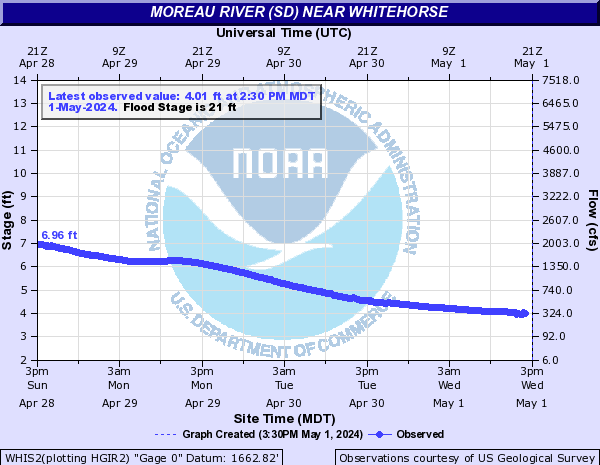
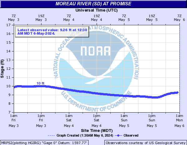
Moreau River (SD) (Click on an image to go to hydrograph webpage)
FTHS2:

WHIS2:
MRPS2:
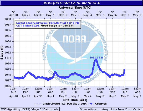
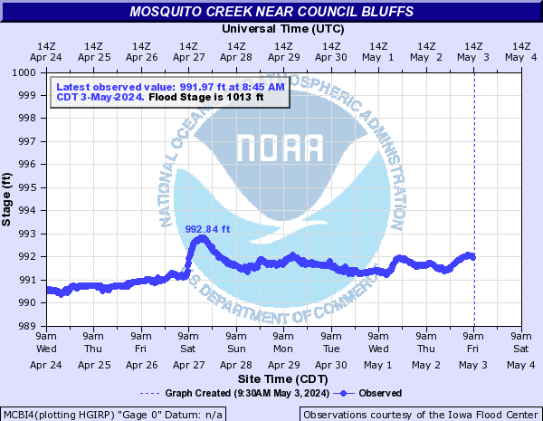
Mosquito Creek (Click on an image to go to hydrograph webpage)
MNEI4:
MCBI4:
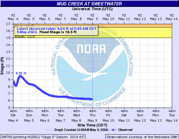
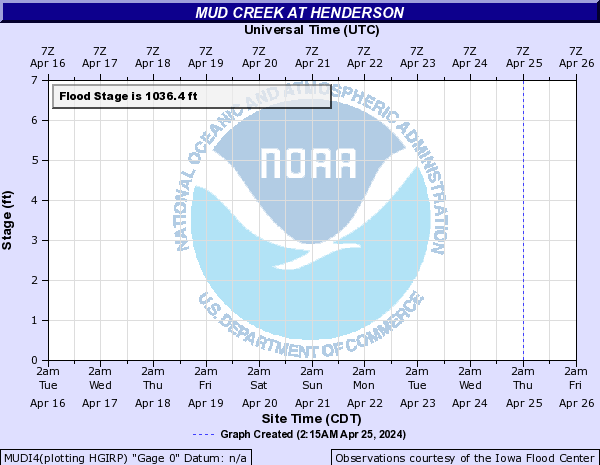
Mud Creek (Click on an image to go to hydrograph webpage)
SWTN1:
MUDI4:
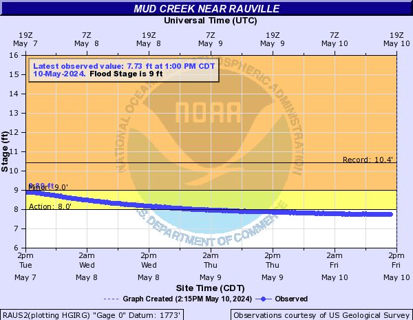
RAUS2:
Mud Creek (NE SD) (Click on an image to go to hydrograph webpage)
MCBS2:

Mud Creek (NW IA) (Click on an image to go to hydrograph webpage)
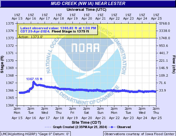
LMCI4:
Mud Lake (Click on an image to go to hydrograph webpage)
MLWM5:

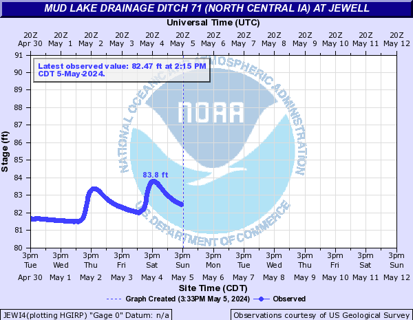
Mud Lake Drainage Ditch 71 (North Central IA) (Click on an image to go to hydrograph webpage)
JEWI4:
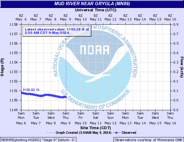
Mud River (Click on an image to go to hydrograph webpage)
MDRM5:
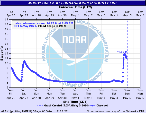
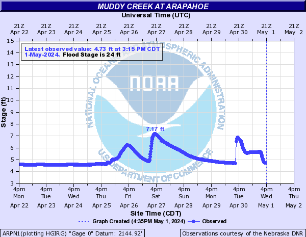
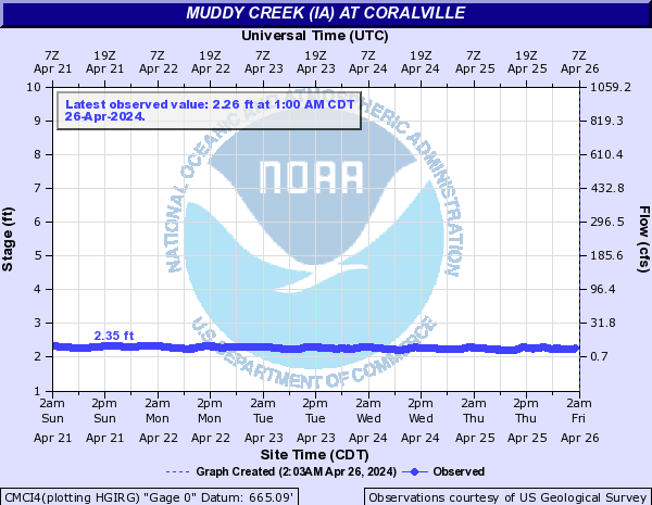
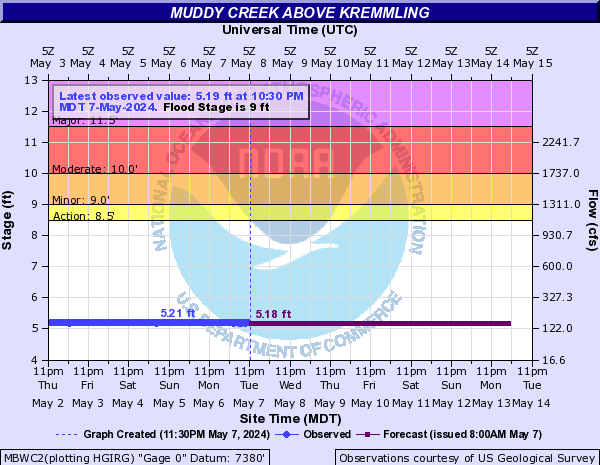
Muddy Creek (Click on an image to go to hydrograph webpage)
ARAN1:
ARPN1:
Muddy Creek (IA) (Click on an image to go to hydrograph webpage)
CMCI4:
Muddy Creek (NC CO) (Click on an image to go to hydrograph webpage)
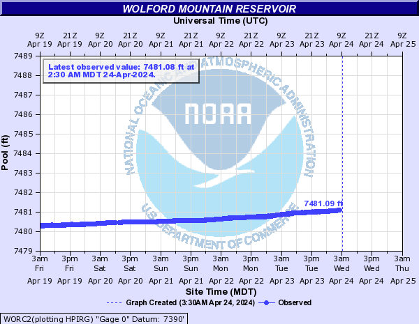
MBWC2:
WORC2:
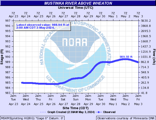
Mustinka River (Click on an image to go to hydrograph webpage)
NCMM5:
WEAM5:

MUSM5:

MSKM5:
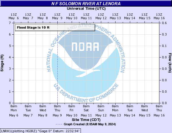
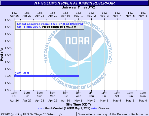
N F Solomon River (Click on an image to go to hydrograph webpage)
LNRK1:
GDEK1:

KRWK1:
PTIK1:

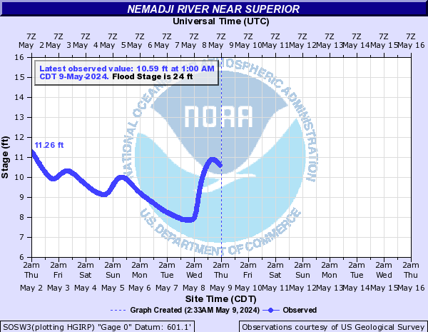
Nemadji River (Click on an image to go to hydrograph webpage)
SOSW3:
NEMM5:
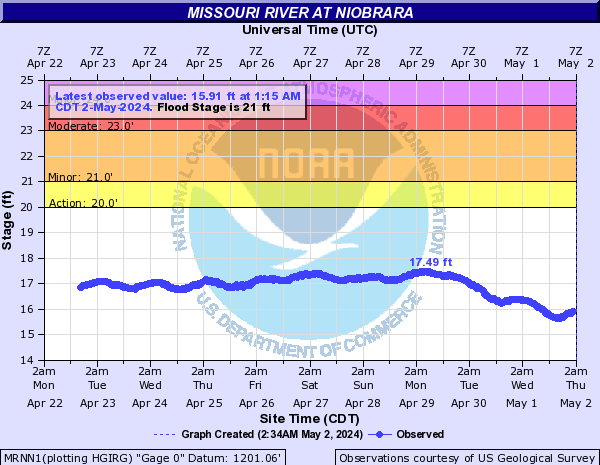
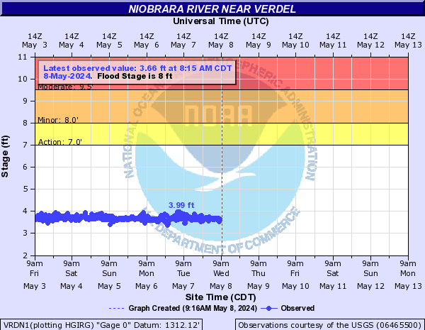
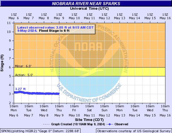
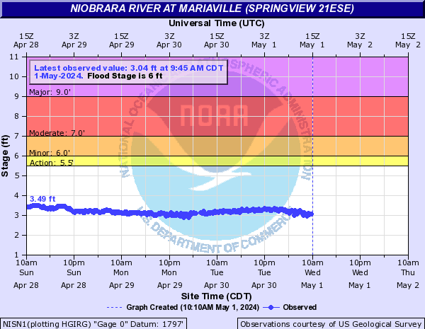
Niobrara River (Click on an image to go to hydrograph webpage)
VRDN1:
SPKN1:
BOXN1:
NISN1:
NRBN1:
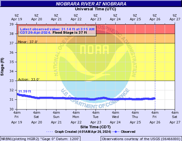
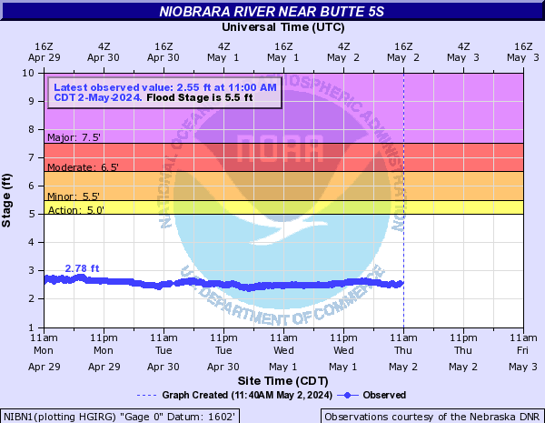
NIBN1:
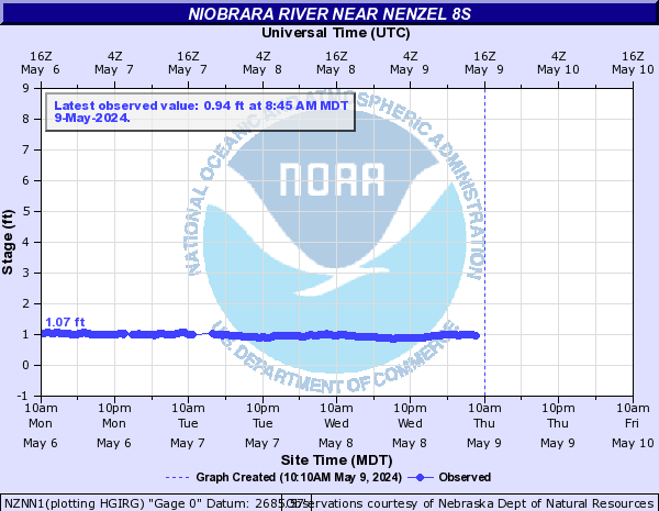
NZNN1:
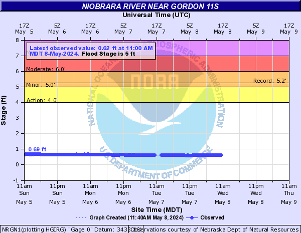
NRGN1:
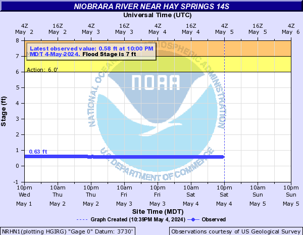
NRHN1:
Nishnabotna River (Click on an image to go to hydrograph webpage)
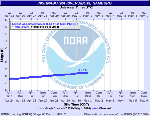
HMBI4:
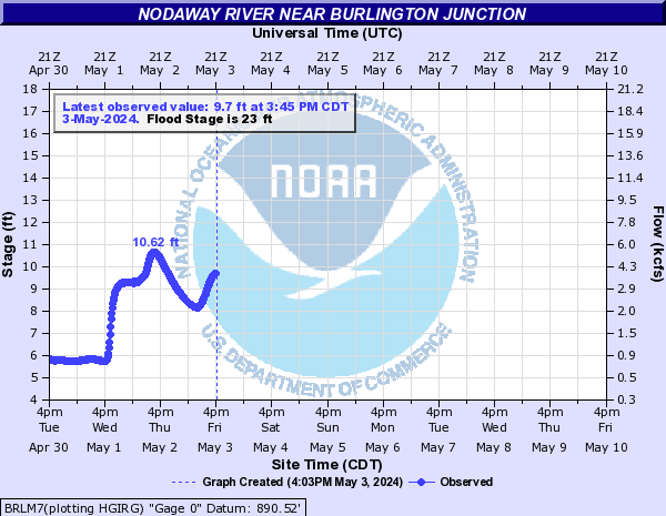
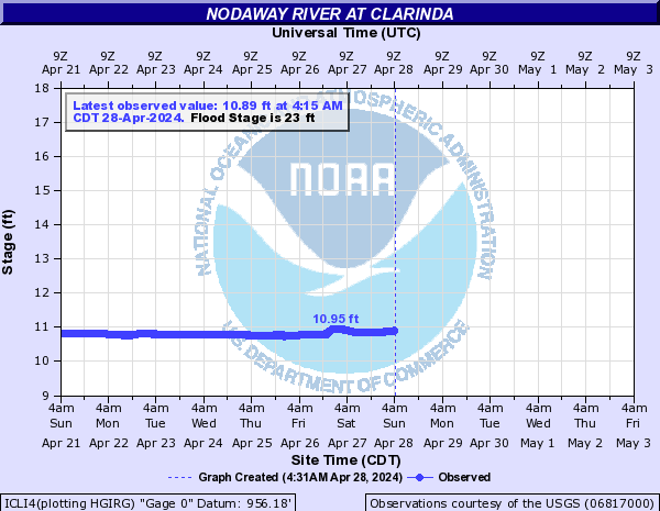
Nodaway River (Click on an image to go to hydrograph webpage)
BRLM7:
ICLI4:
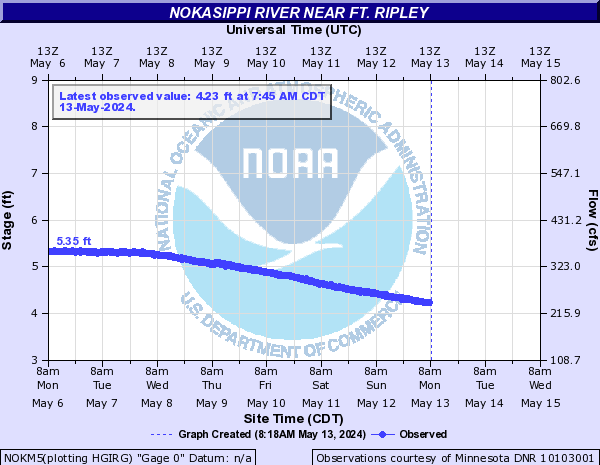
Nokasippi River (Click on an image to go to hydrograph webpage)
NOKM5:
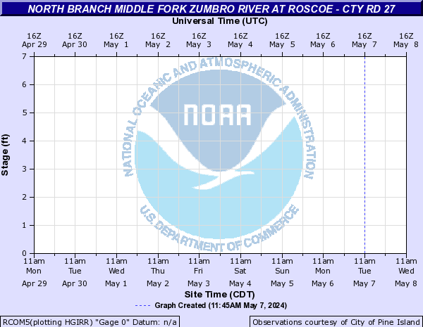
North Branch Middle Fork Zumbro River (Click on an image to go to hydrograph webpage)
PILM5:

ONOM5:
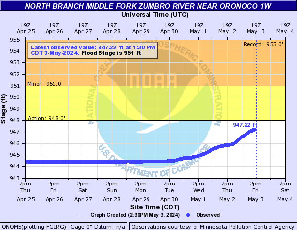
RCOM5:
North Branch of Middle Creek (Click on an image to go to hydrograph webpage)
ERLN1:
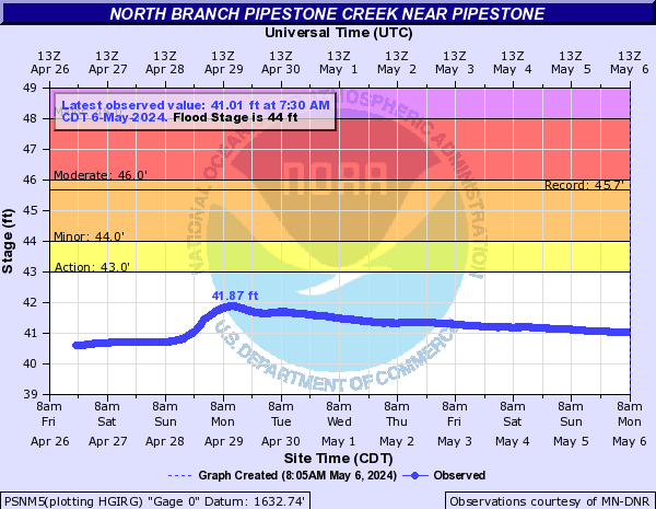
North Branch Pipestone Creek (Click on an image to go to hydrograph webpage)
PSNM5:
North Branch Two Rivers River (Click on an image to go to hydrograph webpage)
NCTM5:
NOTM5:

North Clear Creek (CO) (Click on an image to go to hydrograph webpage)
BHKC2:

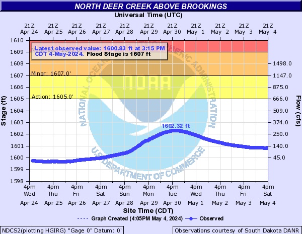
North Deer Creek (Click on an image to go to hydrograph webpage)
NDCS2:
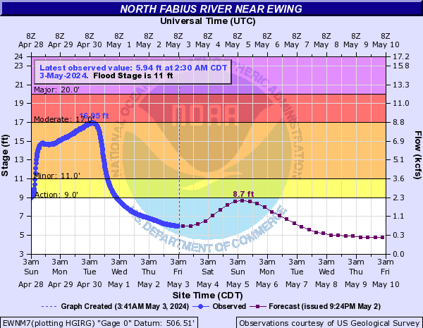
North Fabius River (Click on an image to go to hydrograph webpage)
EWNM7:
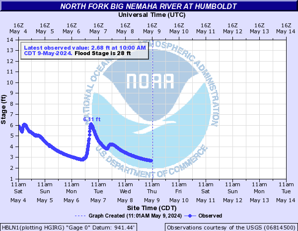
North Fork Big Nemaha River (Click on an image to go to hydrograph webpage)
HBLN1:
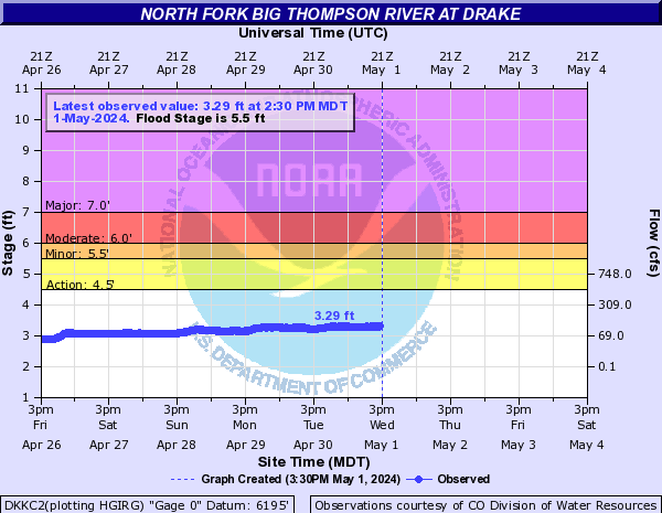
North Fork Big Thompson River (CO) (Click on an image to go to hydrograph webpage)
DKKC2:
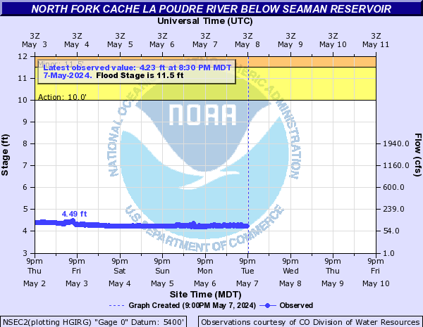
North Fork Cache La Poudre River (Click on an image to go to hydrograph webpage)
NCHC2:
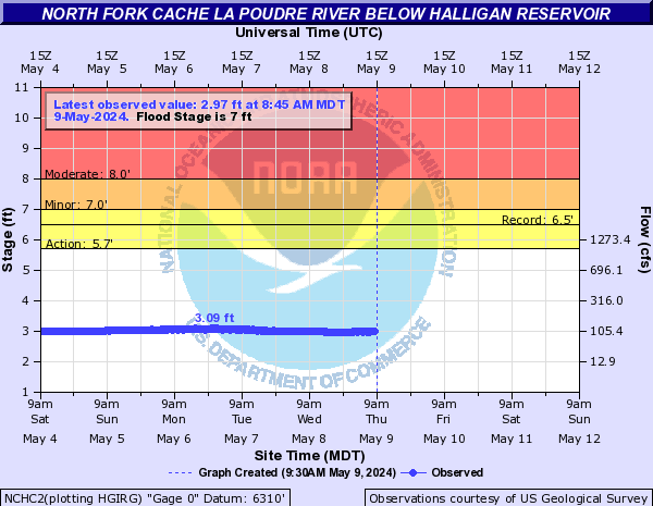
NSEC2:
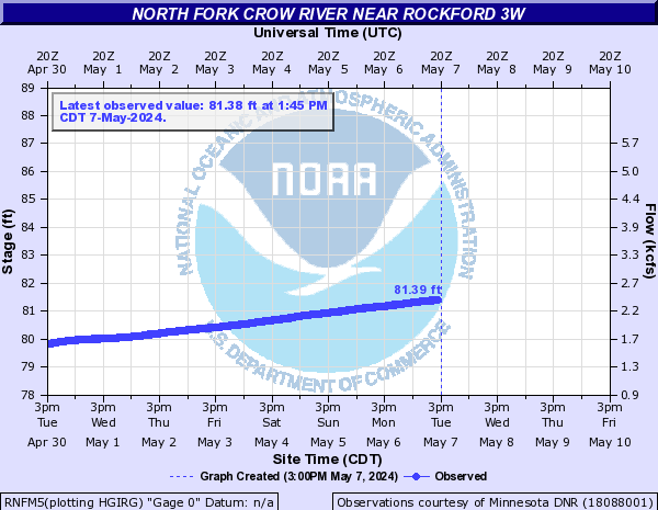
North Fork Crow River (Click on an image to go to hydrograph webpage)
MNHM5:

RNFM5:
PVLM5:

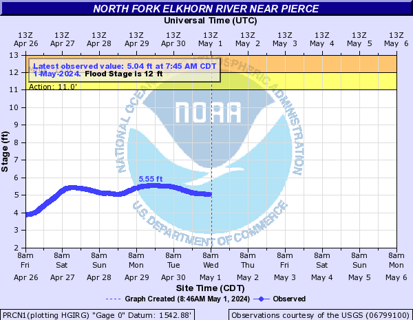
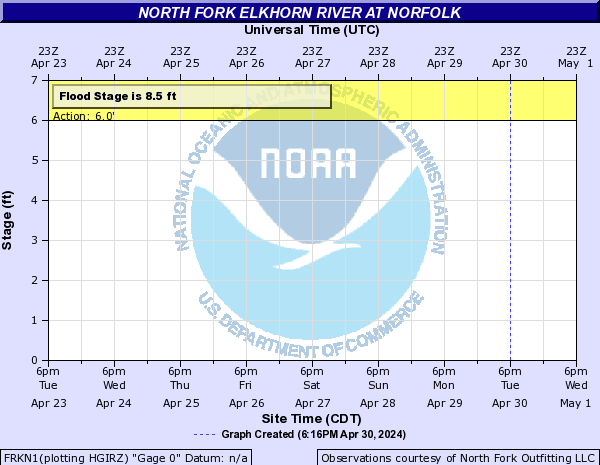
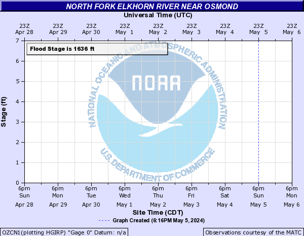
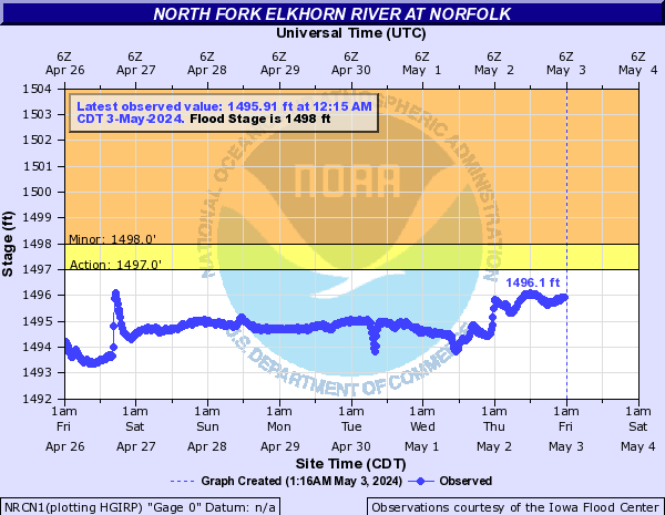
North Fork Elkhorn River (Click on an image to go to hydrograph webpage)
PRCN1:
FRKN1:
OZCN1:
NRCN1:
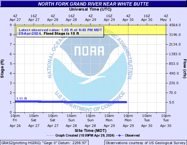
North Fork Grand River (SD) (Click on an image to go to hydrograph webpage)
GRAS2:
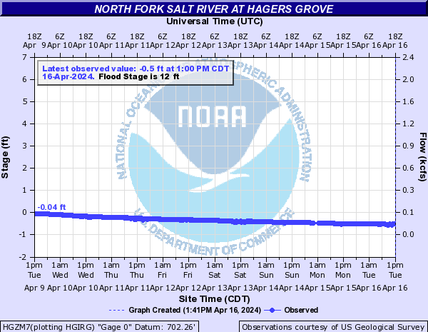
North Fork Salt River (Click on an image to go to hydrograph webpage)
HGZM7:
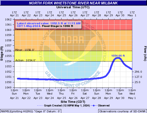
North Fork Whetstone River (Click on an image to go to hydrograph webpage)
NWMS2:
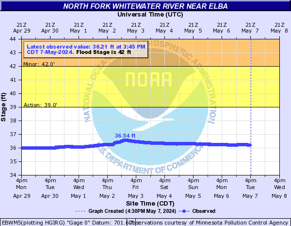
North Fork Whitewater River (Click on an image to go to hydrograph webpage)
EBWM5:
North Fork Yellow Bank River (Click on an image to go to hydrograph webpage)
MYBS2:

North Fork Zumbro River (Click on an image to go to hydrograph webpage)
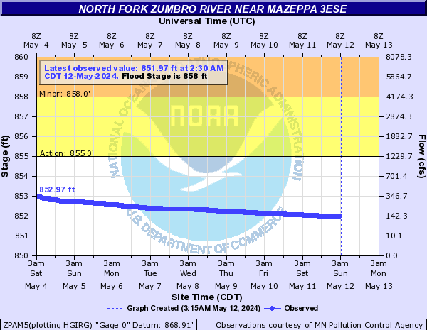
ZPAM5:
KENM5:

MAZM5:

WGOM5:

North Loup River (Click on an image to go to hydrograph webpage)
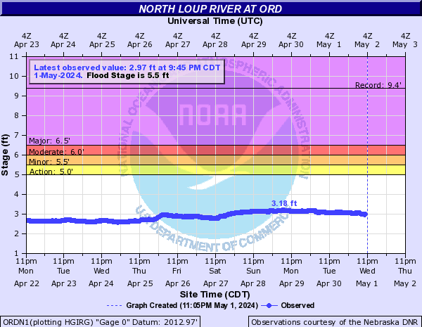
ORDN1:
TYLN1:

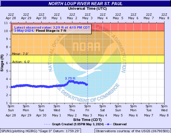
SPUN1:
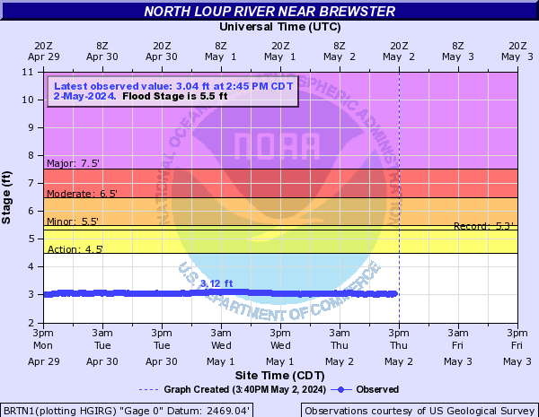
BRTN1:
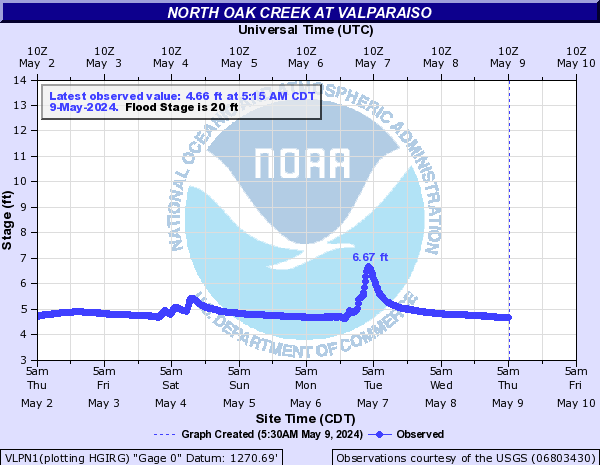
North Oak Creek (Click on an image to go to hydrograph webpage)
VLPN1:
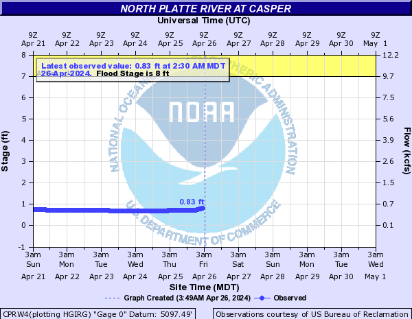
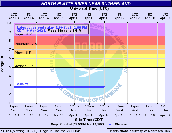
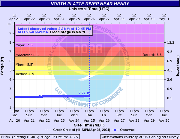
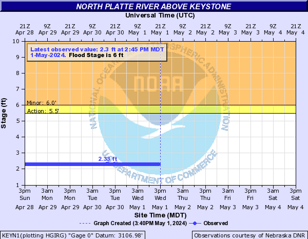
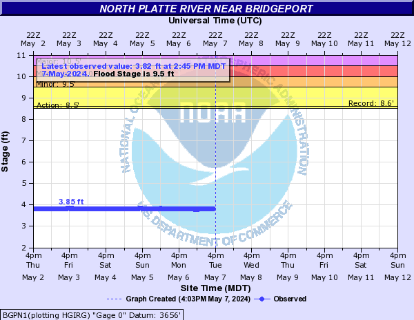
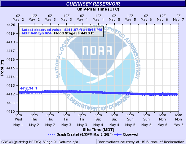
North Platte River (Click on an image to go to hydrograph webpage)
LSON1:

CPRW4:
NGTC2:

LEWN1:

GLNW4:

KNGN1:

ORIW4:

SUTN1:
HENN1:
NPTN1:

MICN1:

KEYN1:
SBRN1:

MNTN1:

BGPN1:
GLEW4:

GNSW4:
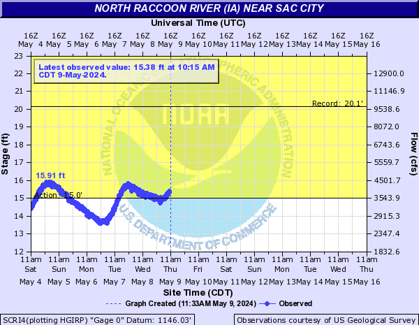
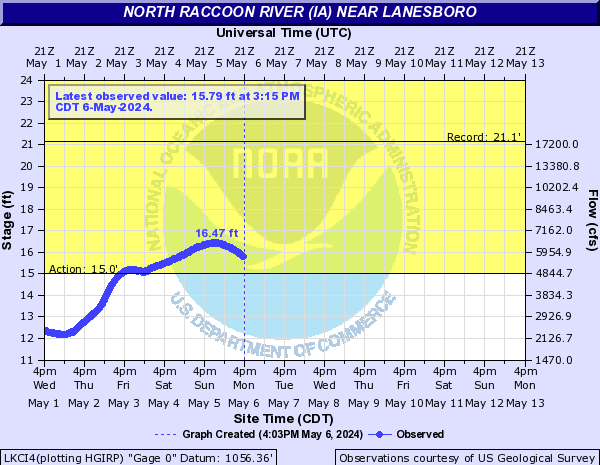
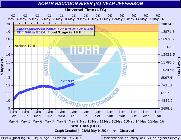
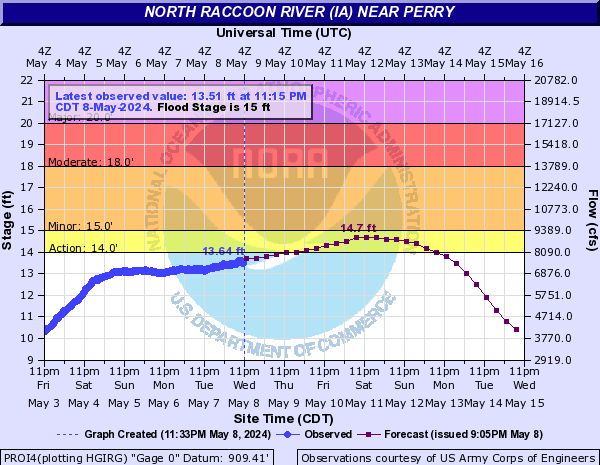
North Raccoon River (IA) (Click on an image to go to hydrograph webpage)
SCRI4:
LKCI4:
EFWI4:
PROI4:
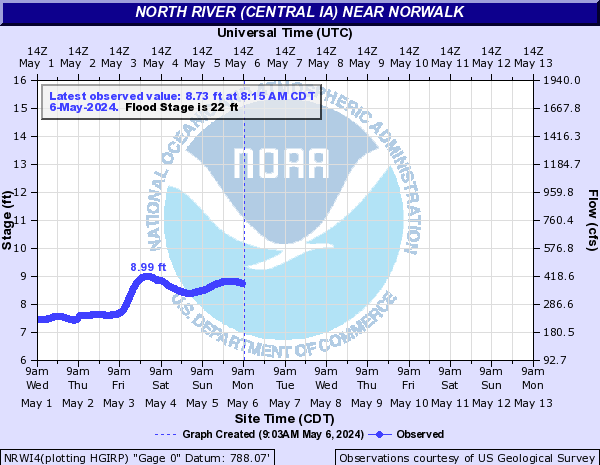
North River (Central IA) (Click on an image to go to hydrograph webpage)
NRWI4:
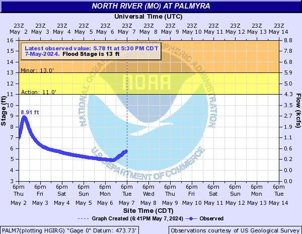
North River (MO) (Click on an image to go to hydrograph webpage)
PALM7:
North Saint Vrain Creek (CO) (Click on an image to go to hydrograph webpage)
NSVC2:

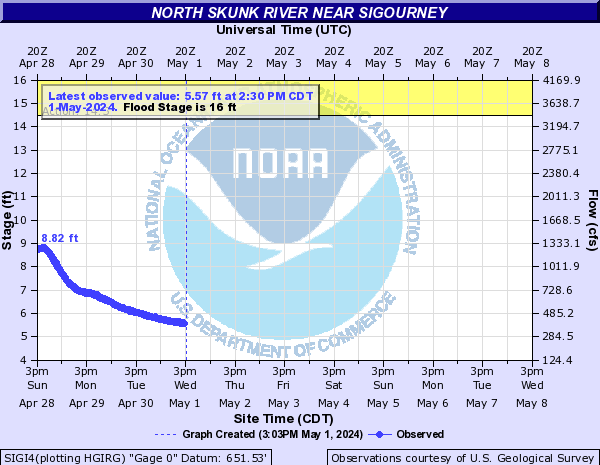
North Skunk River (Click on an image to go to hydrograph webpage)
SIGI4:
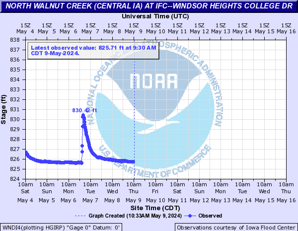
North Walnut Creek (Central IA) (Click on an image to go to hydrograph webpage)
UBNI4:

URBI4:
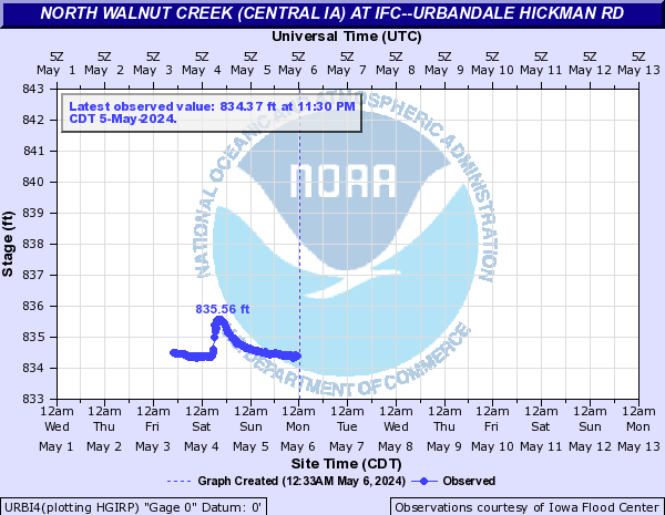
WNDI4:
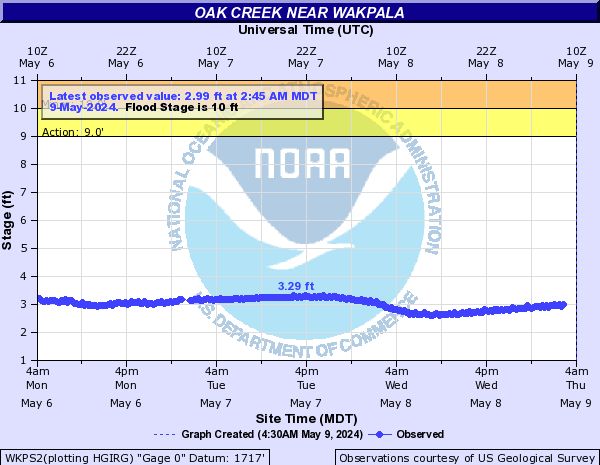
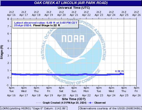
Oak Creek (Click on an image to go to hydrograph webpage)
WKPS2:
RAYN1:
LOKN1:
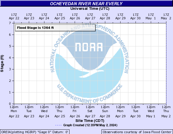
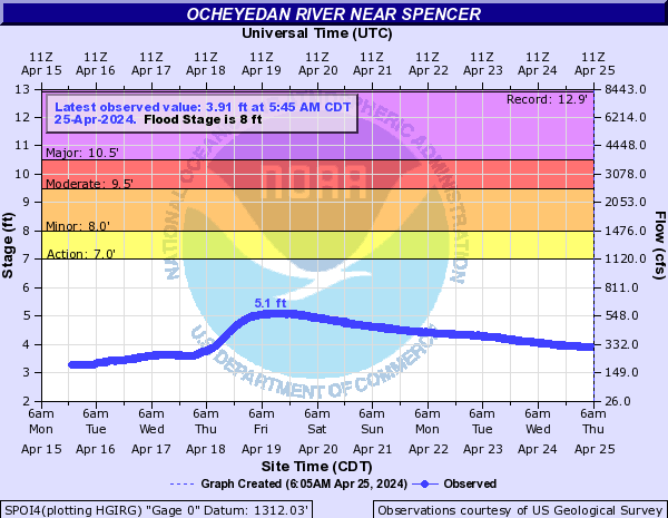
Ocheyedan River (Click on an image to go to hydrograph webpage)
MAYI4:
OREI4:
SPOI4:
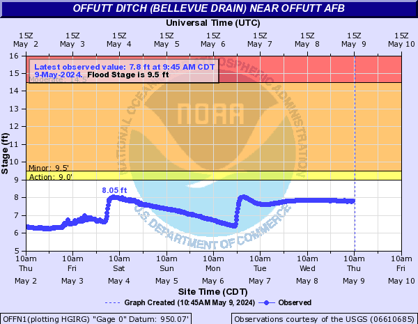
Offutt Ditch (Bellevue Drain) (Click on an image to go to hydrograph webpage)
OFFN1:
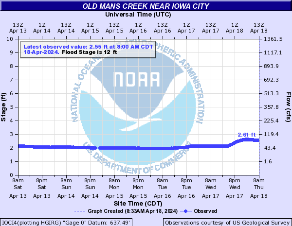
Old Mans Creek (Click on an image to go to hydrograph webpage)
IOCI4:
Olive Branch (Click on an image to go to hydrograph webpage)
SPGN1:
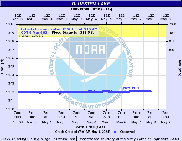
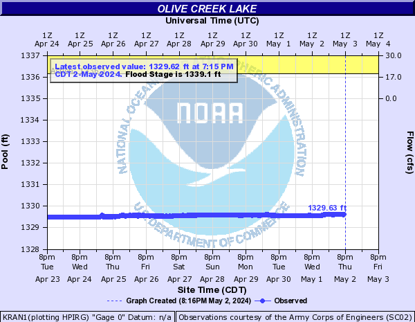
Olive Creek (Click on an image to go to hydrograph webpage)
KRAN1:
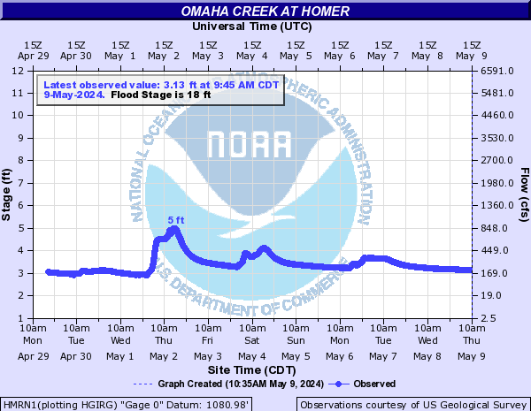
Omaha Creek (Click on an image to go to hydrograph webpage)
HMRN1:
Otter Creek (Click on an image to go to hydrograph webpage)
OCAM8:

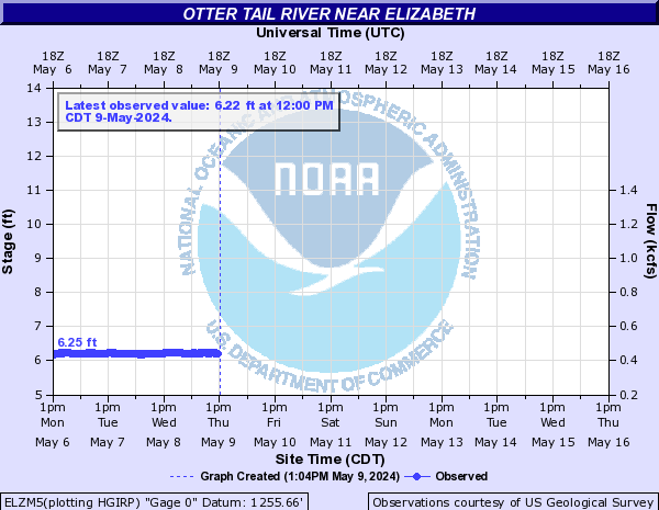
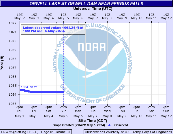
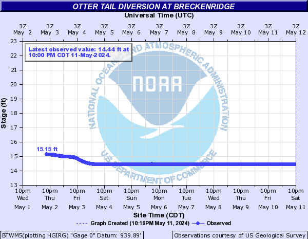
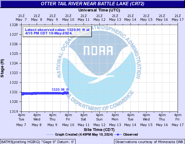
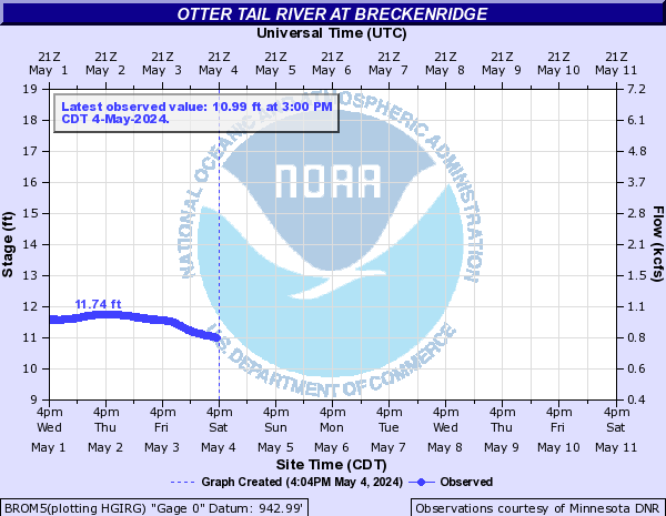
Otter Tail River (Click on an image to go to hydrograph webpage)
ELZM5:
ORWM5:
BTWM5:
BATM5:
BROM5:
RCTM5:

OTRM5:
Papillion Creek (Click on an image to go to hydrograph webpage)
FCKN1:
PHRN1:
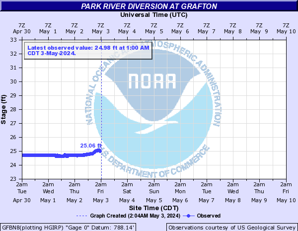
Park River (Click on an image to go to hydrograph webpage)
GRNN8:
GFBN8:
Pebble Creek (Click on an image to go to hydrograph webpage)
SRBN1:

PEBN1:

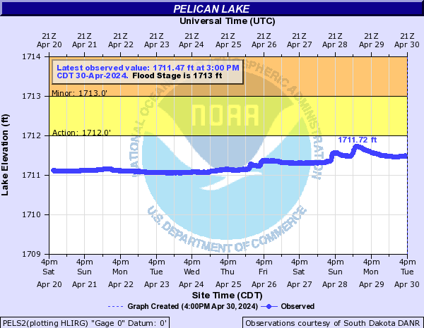
Pelican Lake (Click on an image to go to hydrograph webpage)
PELS2:
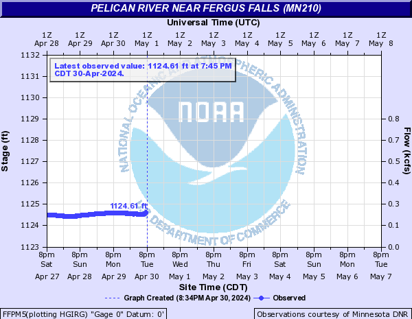
Pelican River (Click on an image to go to hydrograph webpage)
FFPM5:
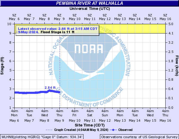
Pembina River (Click on an image to go to hydrograph webpage)
WLHN8:
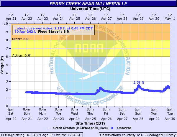
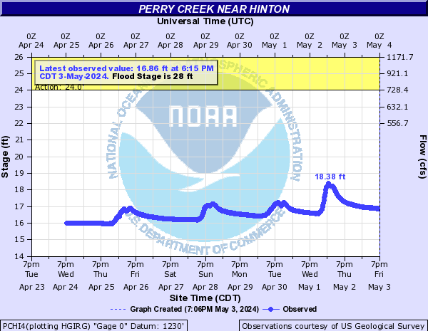
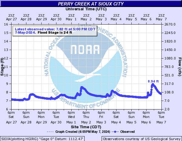
Perry Creek (Click on an image to go to hydrograph webpage)
PCMI4:
PCHI4:
SIOI4:
Pilot Creek (Central IA) (Click on an image to go to hydrograph webpage)
RLFI4:

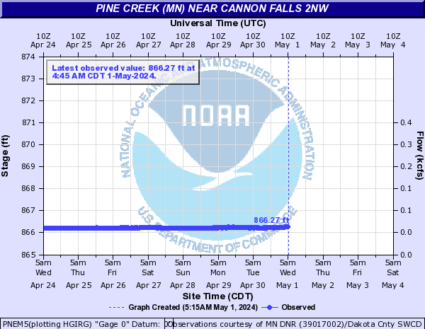
Pine Creek (MN) (Click on an image to go to hydrograph webpage)
PNEM5:
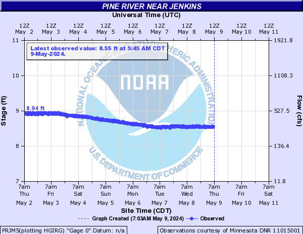
Pine River (Click on an image to go to hydrograph webpage)
PRJM5:
MISM5:

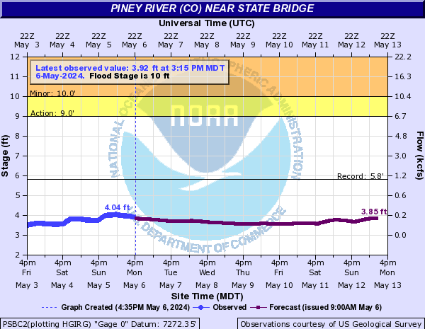
Piney River (CO) (Click on an image to go to hydrograph webpage)
PSBC2:
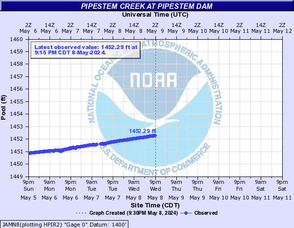
Pipestem Creek (Click on an image to go to hydrograph webpage)
PGEN8:
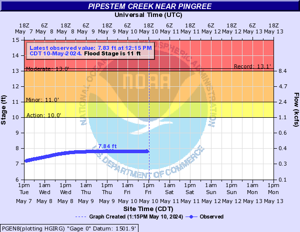
JAMN8:
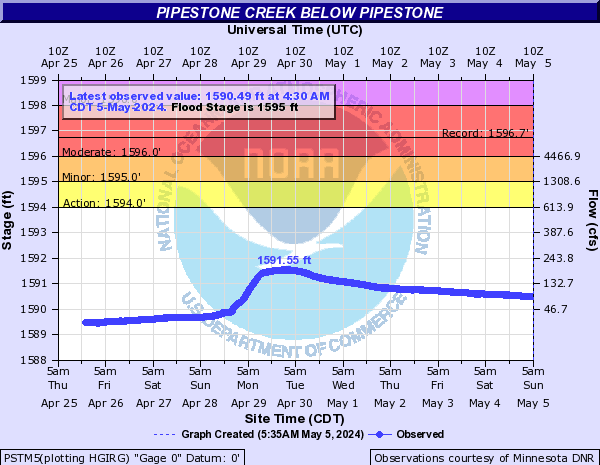
Pipestone Creek (Click on an image to go to hydrograph webpage)
PIPM5:
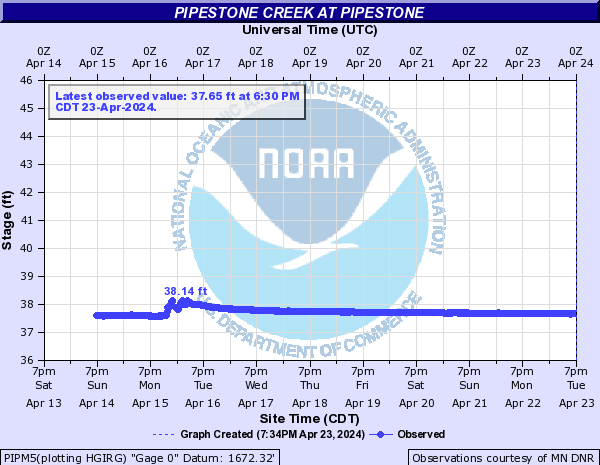
PSTM5:
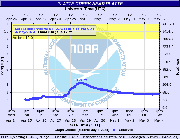
Platte Creek (Click on an image to go to hydrograph webpage)
PCPS2:
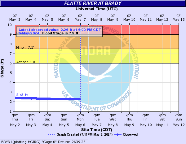
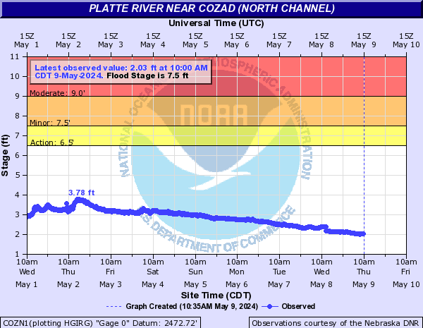
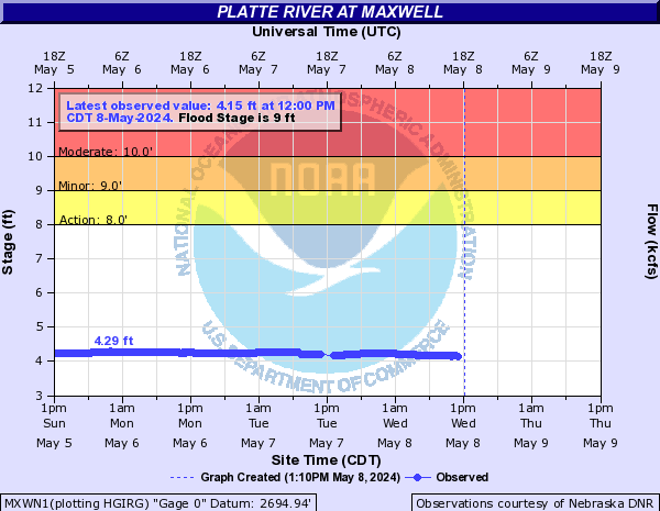
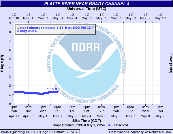
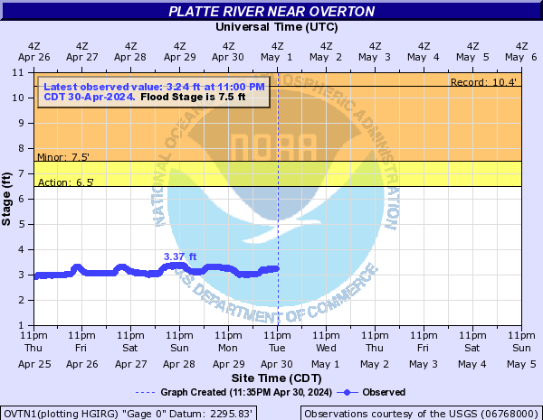
Platte River (Click on an image to go to hydrograph webpage)
BDYN1:
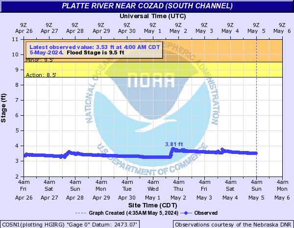
COSN1:
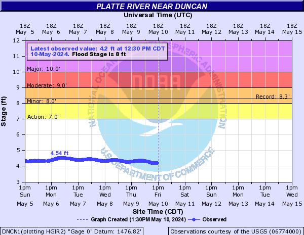
DNCN1:
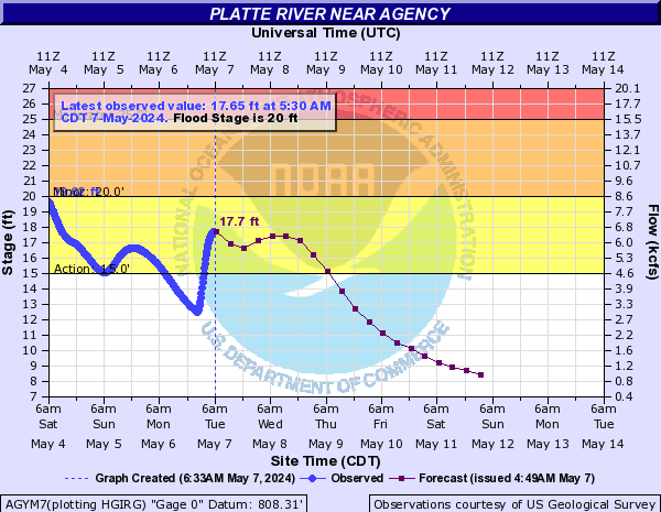
AGYM7:
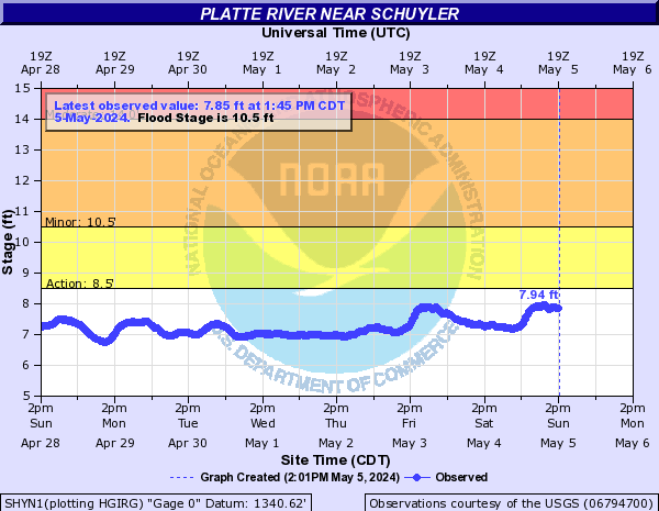
SHYN1:
COZN1:
DARN1:

MXWN1:
BRAN1:
NBDN1:

OVTN1:
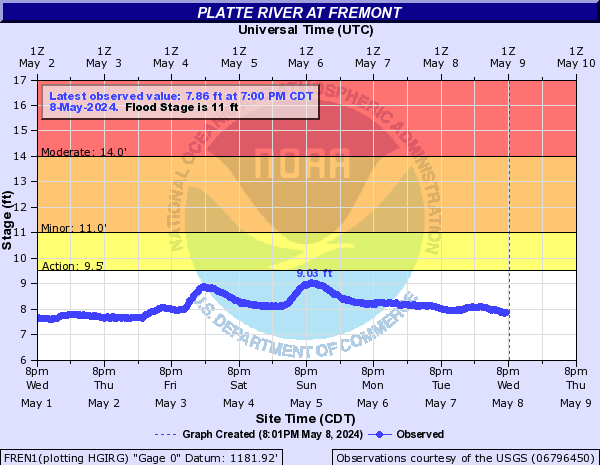
FREN1:
KEAN1:

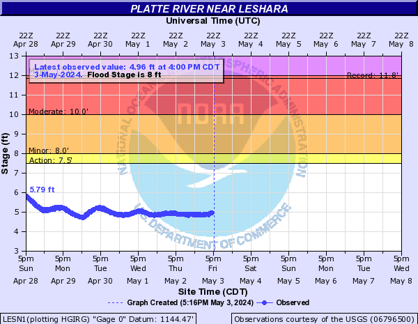
LESN1:
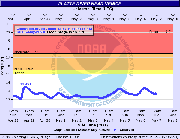
VENN1:
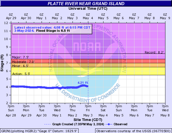
GRIN1:
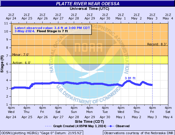
ODSN1:
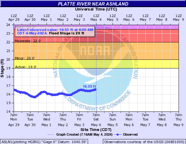
ASLN1:
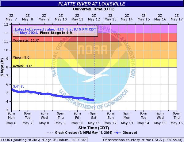
LOUN1:
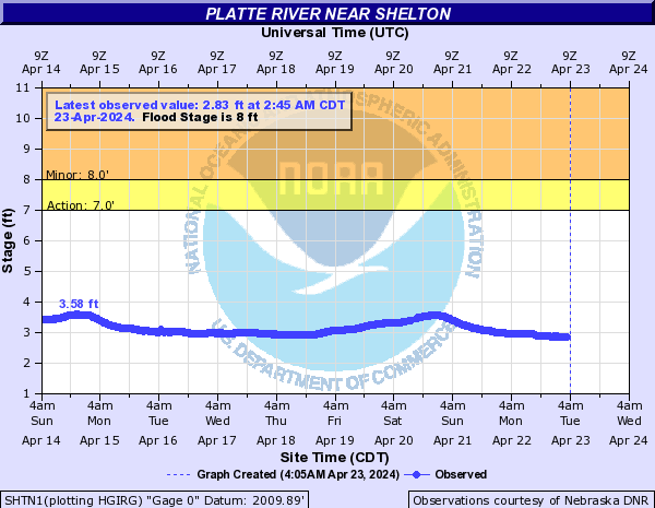
SHTN1:
Platte River (MN) (Click on an image to go to hydrograph webpage)
PLRM5:
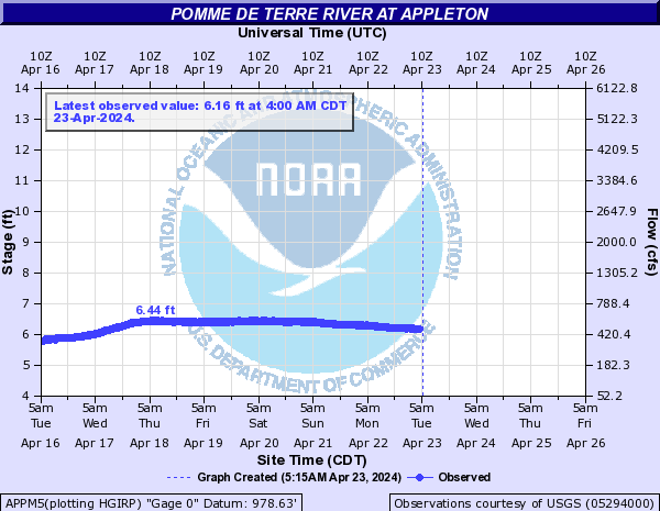
Pomme De Terre River (Click on an image to go to hydrograph webpage)
HOFM5:

APPM5:
Ponca Creek (Click on an image to go to hydrograph webpage)
VERN1:

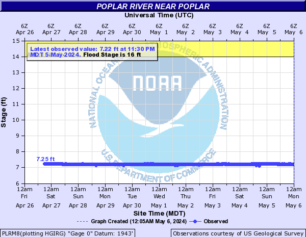
Poplar River (Click on an image to go to hydrograph webpage)
PLRM8:
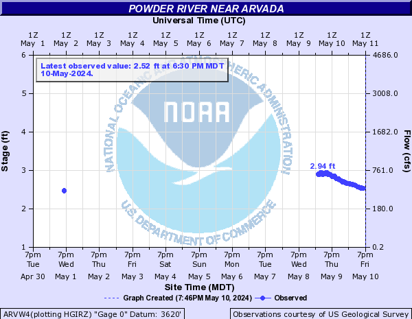
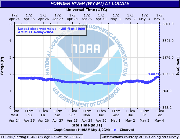
Powder River (WY-MT) (Click on an image to go to hydrograph webpage)
ARVW4:
MHDM8:

LOCM8:
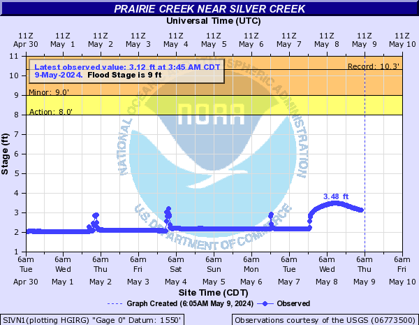
Prairie Creek (Click on an image to go to hydrograph webpage)
SIVN1:
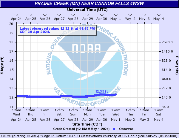
Prairie Creek (MN) (Click on an image to go to hydrograph webpage)
CNPM5:
Prairie Dog Creek (Click on an image to go to hydrograph webpage)
CLNK1:
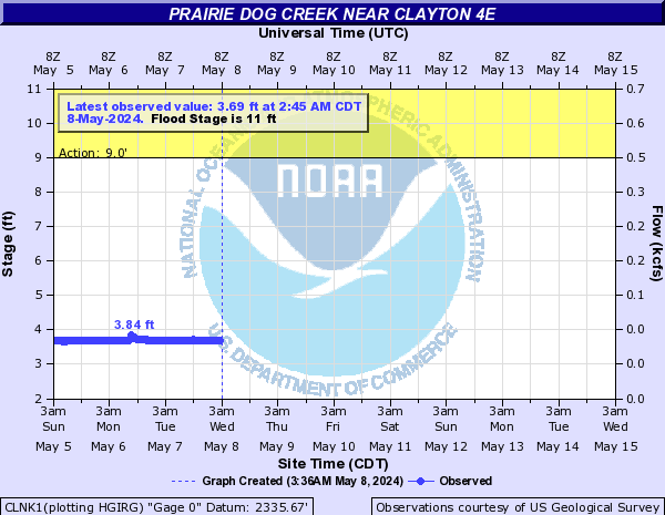
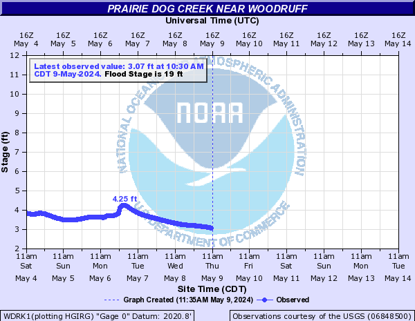
WDRK1:
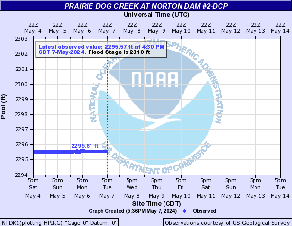
NTDK1:
Prairie River (MN) (Click on an image to go to hydrograph webpage)
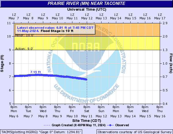
TACM5:
Pumpkin Creek (Click on an image to go to hydrograph webpage)
PMKM8:
Rabbit River (Click on an image to go to hydrograph webpage)
NOPM5:
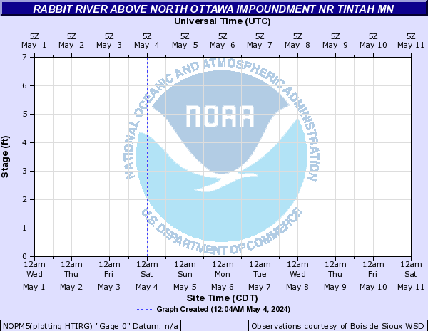
CSRM5:
JAHM5:

Raccoon River (Central IA) (Click on an image to go to hydrograph webpage)
VNMI4:

WDMI4:
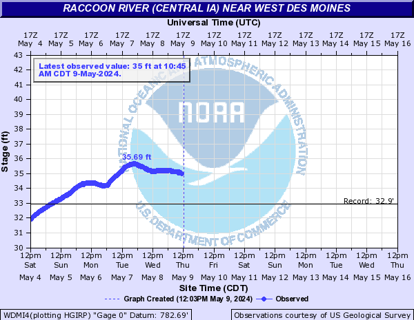
DMWI4:
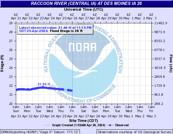
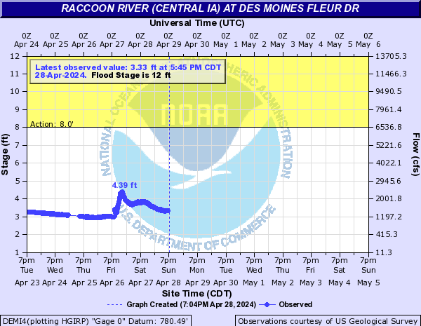
DEMI4:
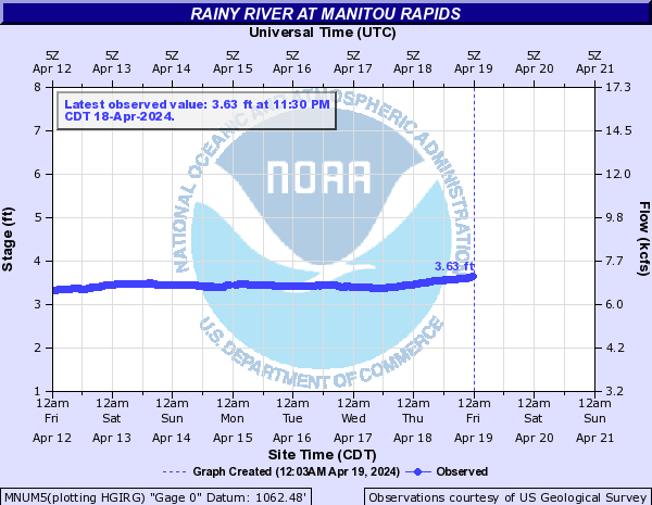
Rainy River (Click on an image to go to hydrograph webpage)
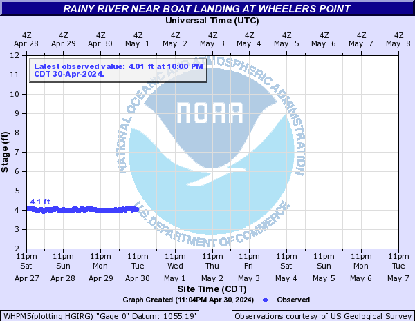
WHPM5:
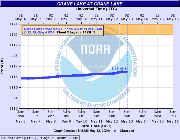
CNLM5:
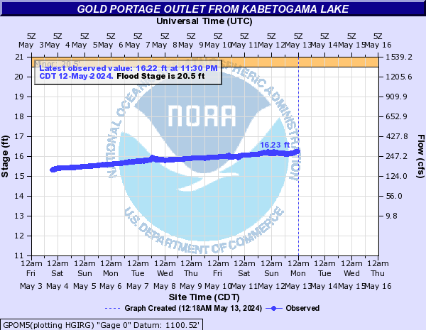
GPOM5:
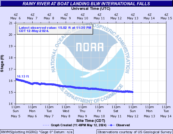
RNYM5:
MNUM5:
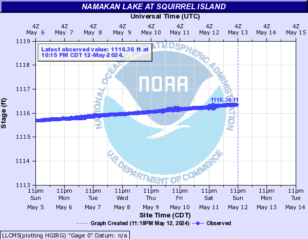
LLCM5:
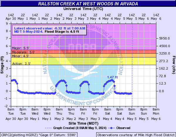
Ralston Creek (CO) (Click on an image to go to hydrograph webpage)
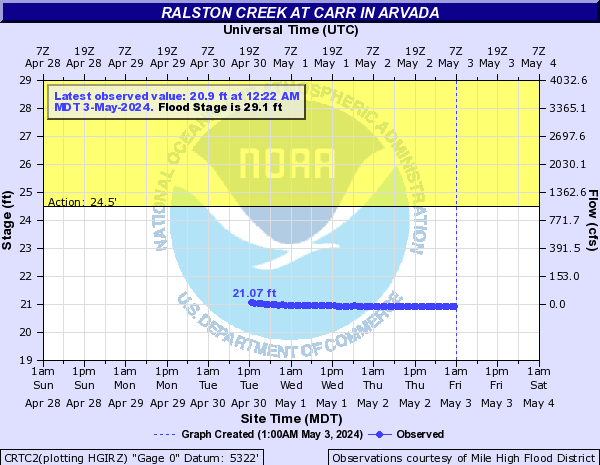
CRTC2:
CRPC2:
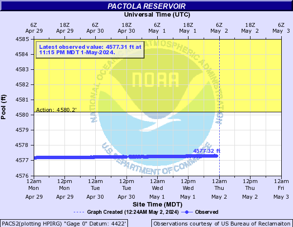
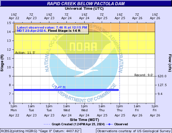
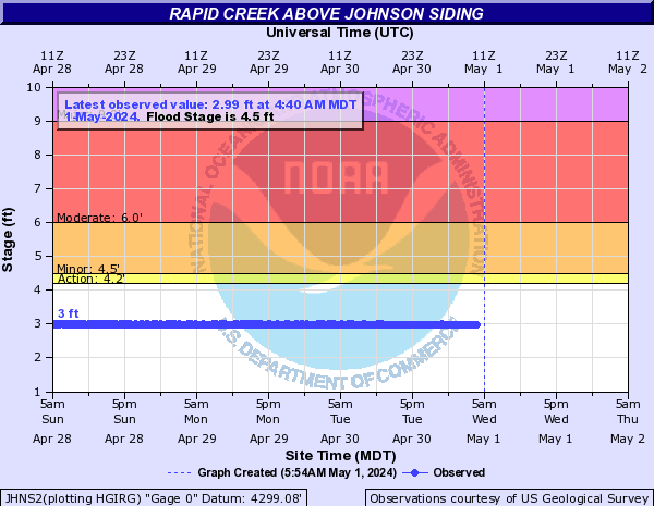
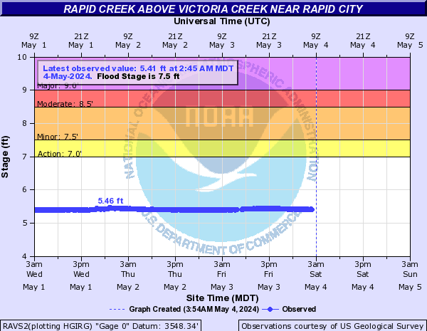
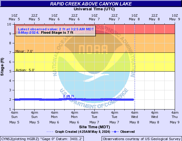
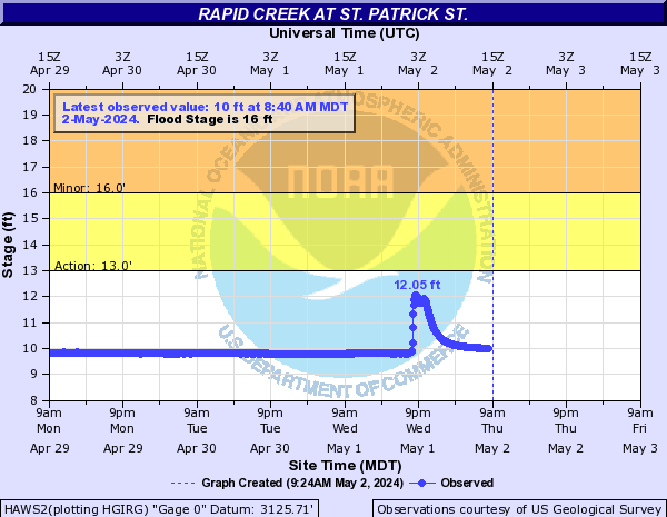
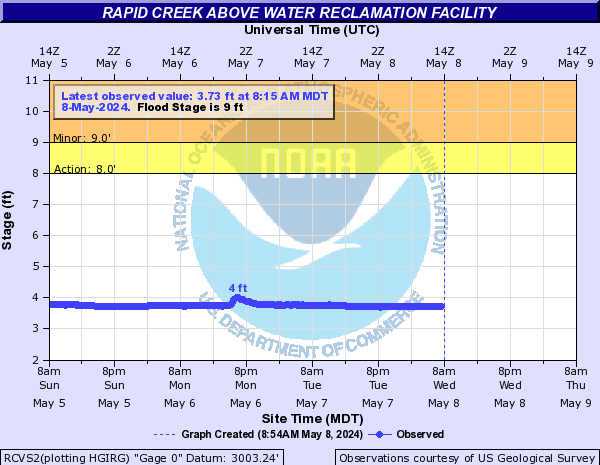
Rapid Creek (Click on an image to go to hydrograph webpage)
RSIS2:

PACS2:
RCBS2:
JHNS2:
BIGS2:

RAVS2:
CYNS2:
RCYS2:

HAWS2:
RCVS2:
FARS2:

Rapid Creek (IA) (Click on an image to go to hydrograph webpage)
IRCI4:

Rapid River (Click on an image to go to hydrograph webpage)
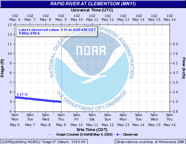
CLEM5:
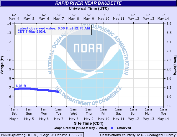
BRRM5:
Red Cedar River (Click on an image to go to hydrograph webpage)
MENW3:

CLXW3:

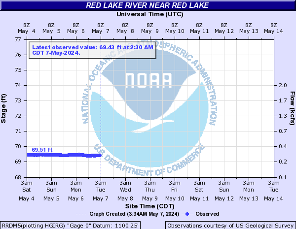
Red Lake River (Click on an image to go to hydrograph webpage)
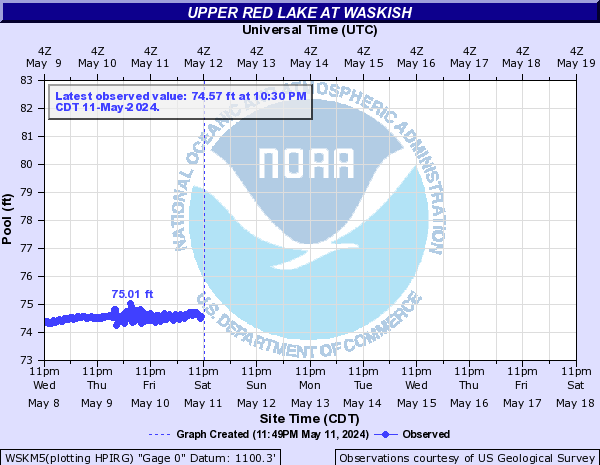
WSKM5:
RRDM5:
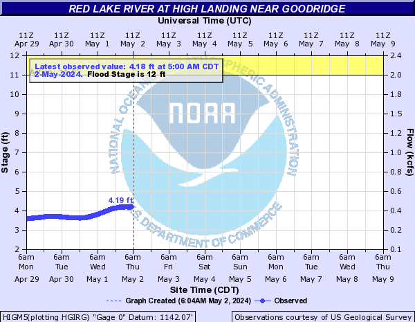
HIGM5:
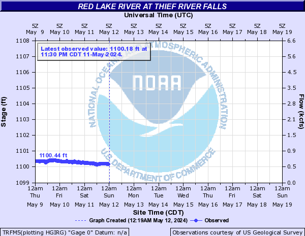
TRFM5:
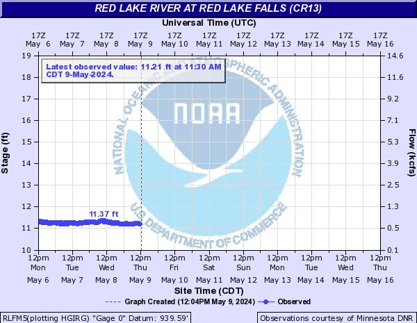
RLFM5:
CRKM5:

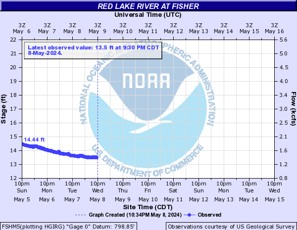
FSHM5:
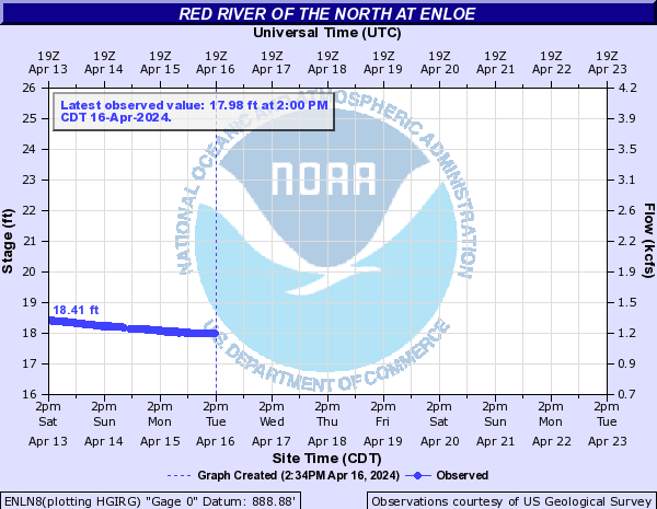
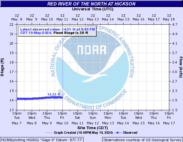
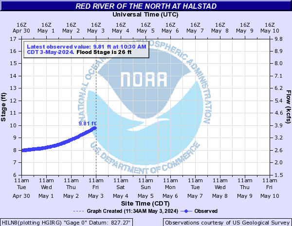
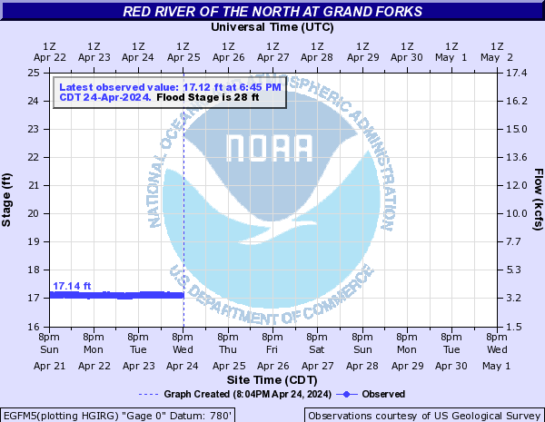
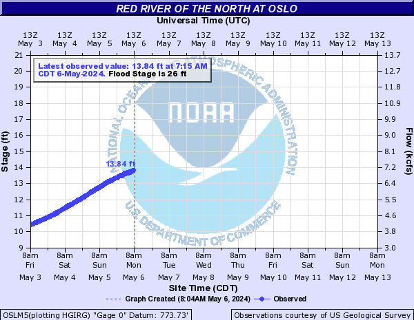
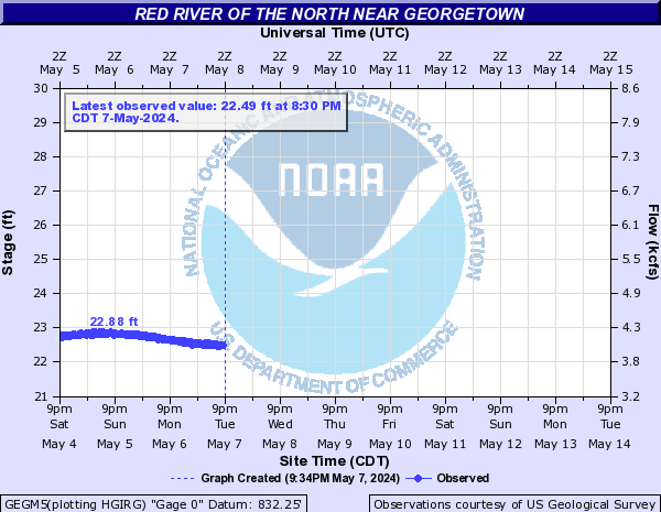
Red River of the North (Click on an image to go to hydrograph webpage)
WHNN8:

ENLN8:
HICN8:
FGON8:

HILN8:
TPNN8:

EGFM5:
OSLM5:
DRTN8:

GEGM5:
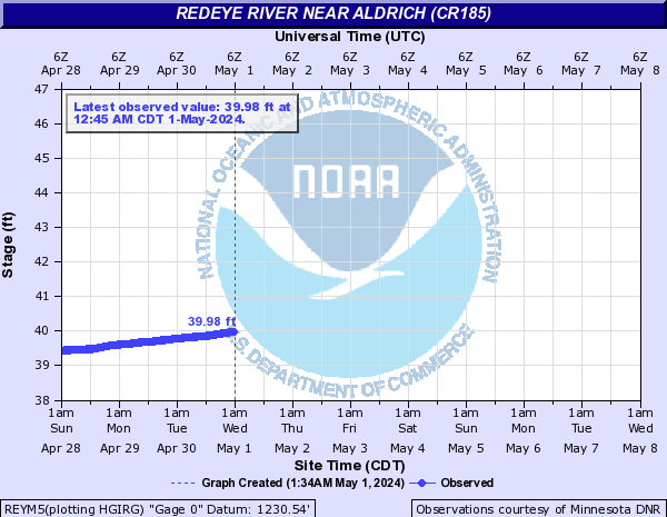
Redeye River (Click on an image to go to hydrograph webpage)
REYM5:
Redwater Creek (WY) (Click on an image to go to hydrograph webpage)
RDWS2:
Redwater River (MT) (Click on an image to go to hydrograph webpage)
RRCM8:

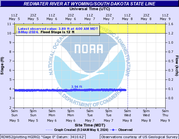
Redwater River (SD) (Click on an image to go to hydrograph webpage)
RWRS2:

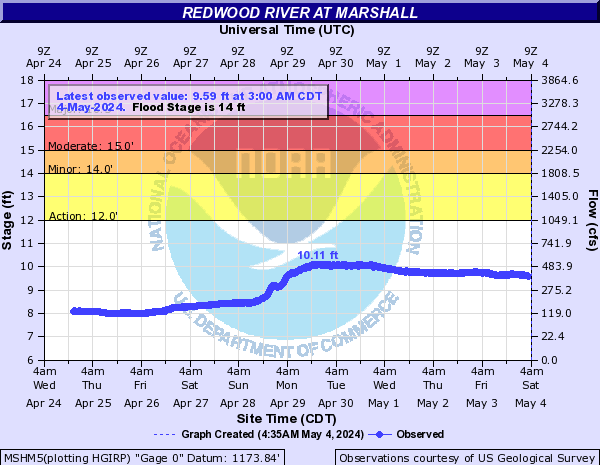
Redwood River (Click on an image to go to hydrograph webpage)
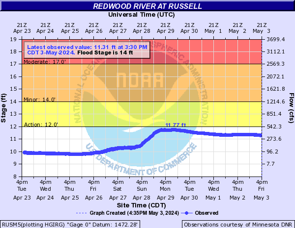
RUSM5:
RWDM5:

MSHM5:
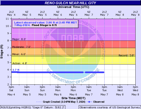
Reno Gulch (Click on an image to go to hydrograph webpage)
RGUS2:
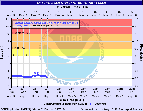
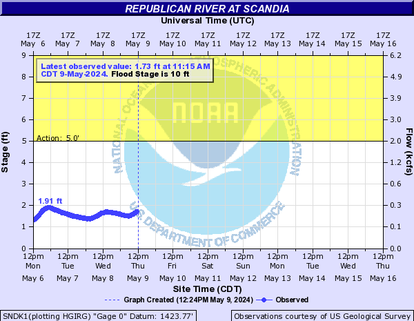
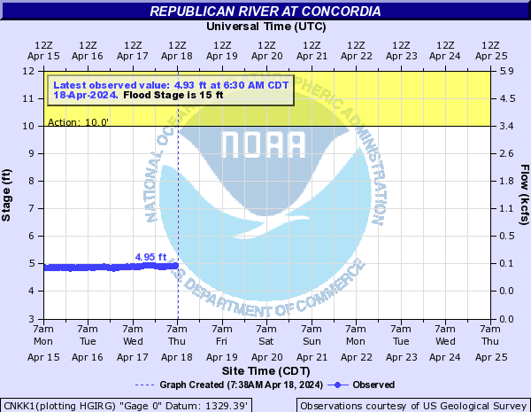
Republican River (Click on an image to go to hydrograph webpage)
BENN1:
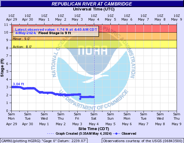
CAMN1:
SNDK1:
CNKK1:
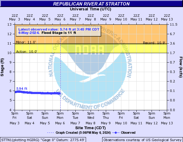
STTN1:
ORNN1:

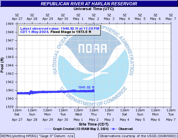
REPN1:
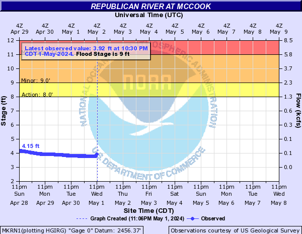
MKRN1:
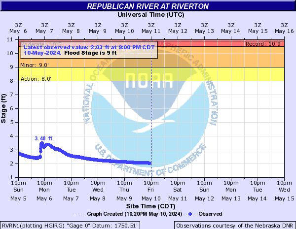
RVRN1:
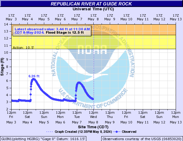
GUIN1:
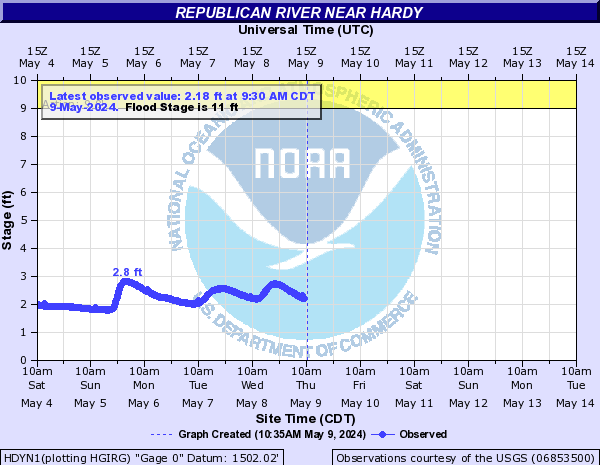
HDYN1:
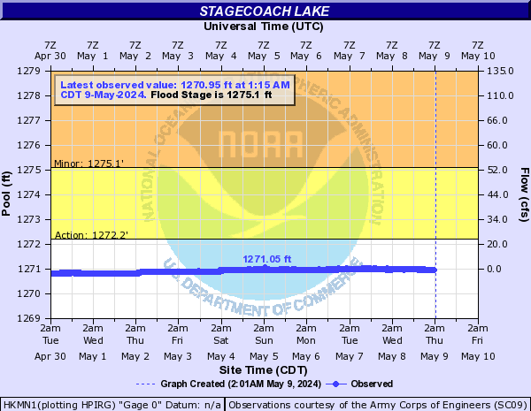
Reservoirs (Click on an image to go to hydrograph webpage)
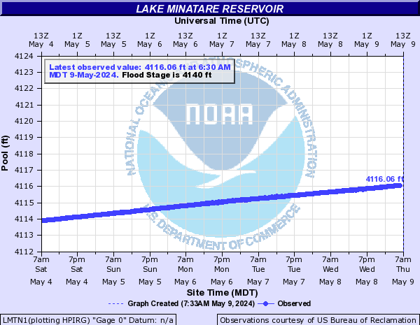
LMTN1:
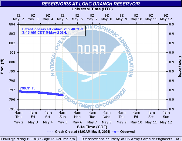
LBRM7:
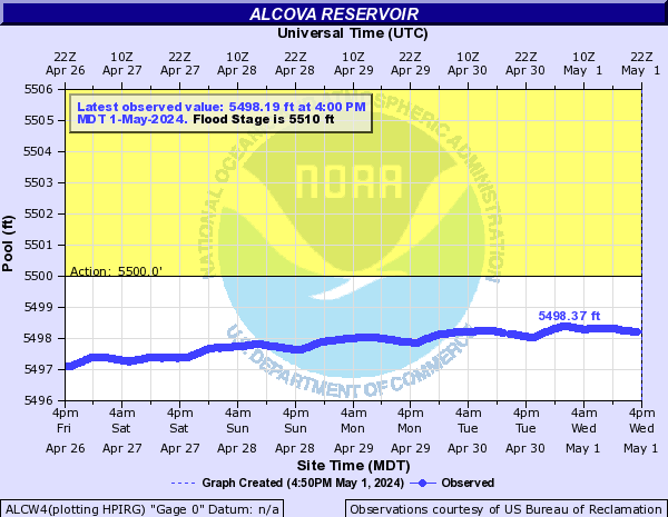
ALCW4:
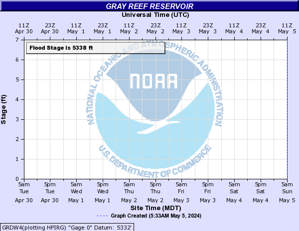
GRDW4:
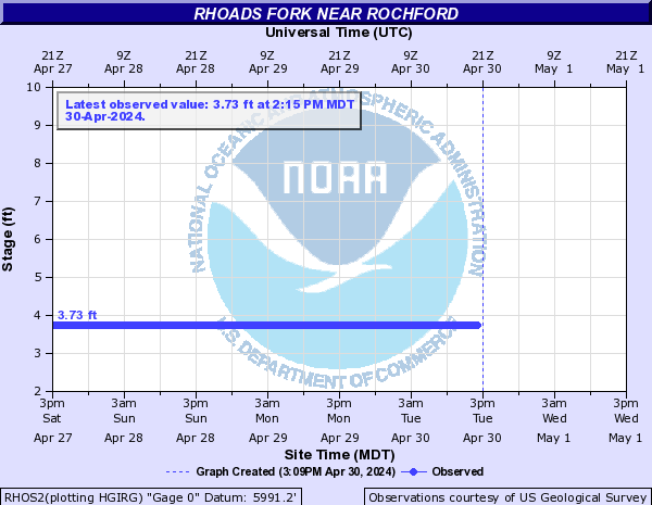
Rhoads Fork (Click on an image to go to hydrograph webpage)
RHOS2:
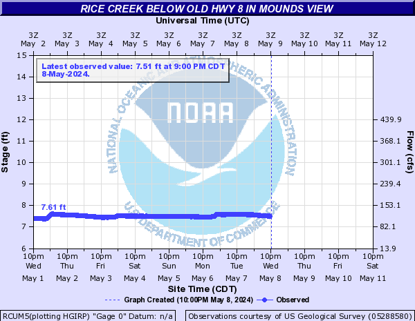
Rice Creek (Click on an image to go to hydrograph webpage)
RCUM5:
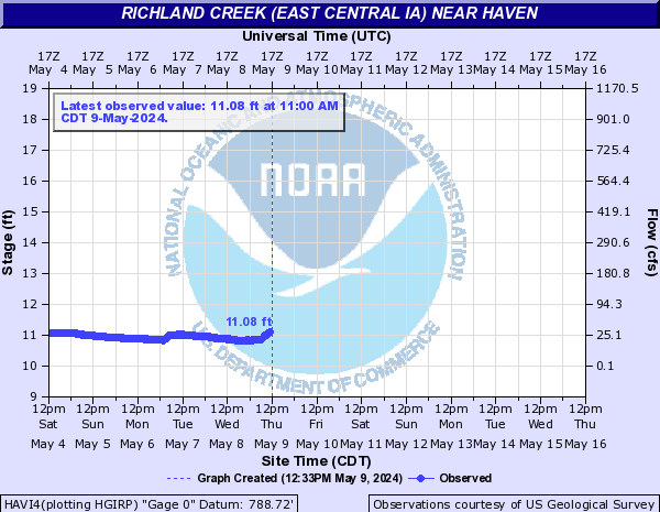
Richland Creek (East Central IA) (Click on an image to go to hydrograph webpage)
HAVI4:
Rock Creek (Click on an image to go to hydrograph webpage)
CERN1:

KCRW4:

Rock River (Click on an image to go to hydrograph webpage)
HRDM5:

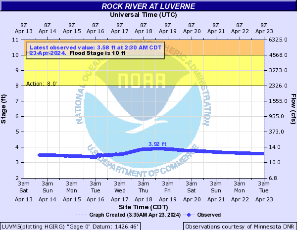
LUVM5:
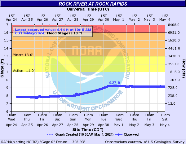
RAPI4:
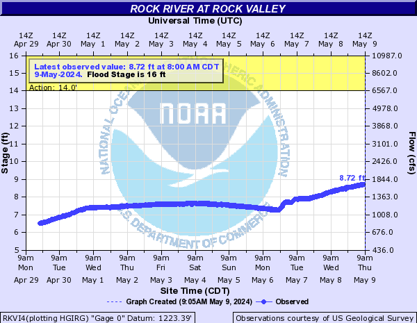
RKVI4:
Rogers Creek (Click on an image to go to hydrograph webpage)
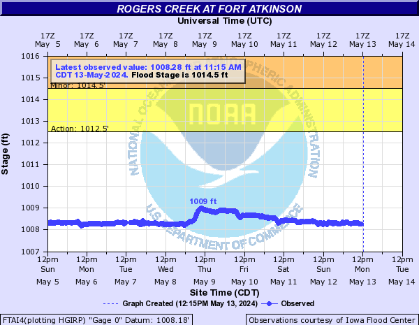
FTAI4:
Root River (MN) (Click on an image to go to hydrograph webpage)
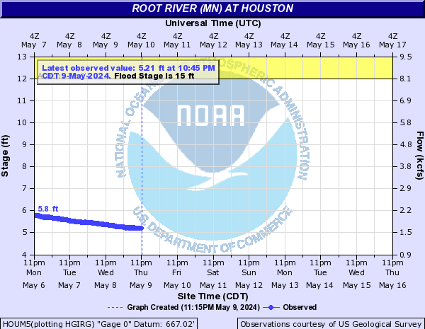
HOUM5:
RPMM5:
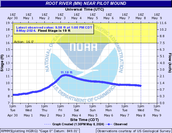
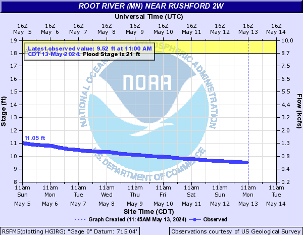
RSFM5:
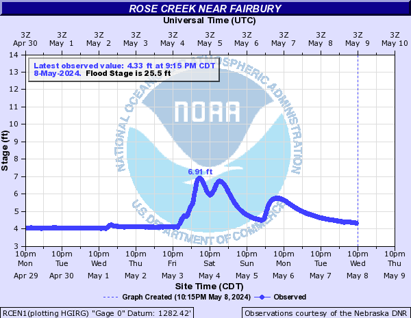
Rose Creek (Click on an image to go to hydrograph webpage)
RCEN1:
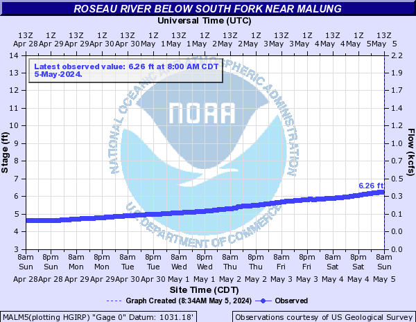
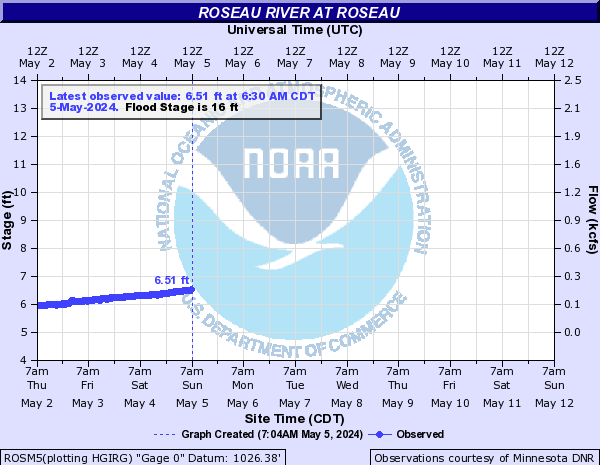
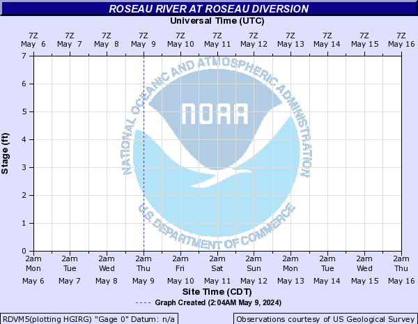
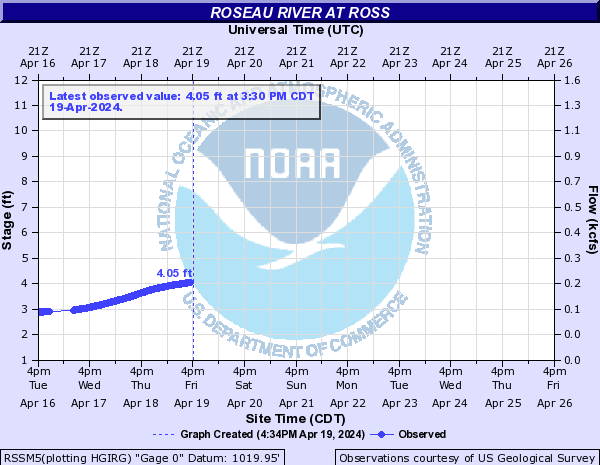
Roseau River (Click on an image to go to hydrograph webpage)
MALM5:
ROSM5:
RDVM5:
RSSM5:
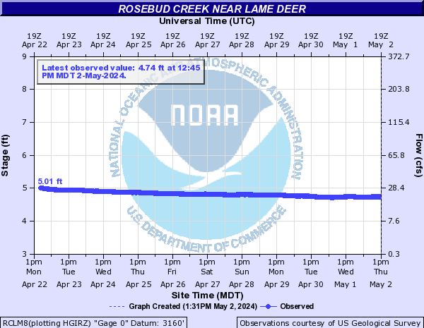
Rosebud Creek (Click on an image to go to hydrograph webpage)
RBDM8:
RCLM8:
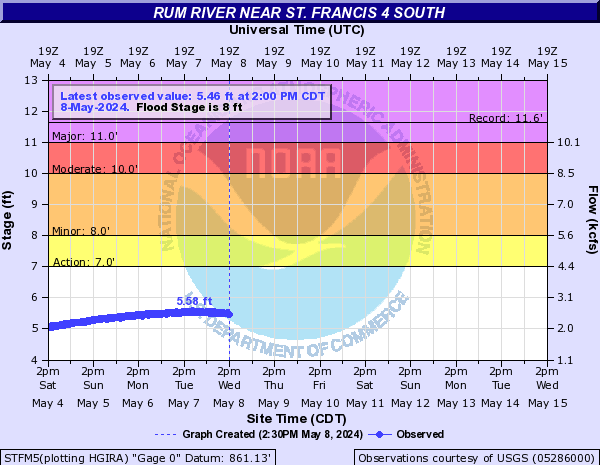
Rum River (Click on an image to go to hydrograph webpage)
ONIM5:
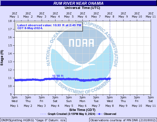
MCAM5:

STFM5:
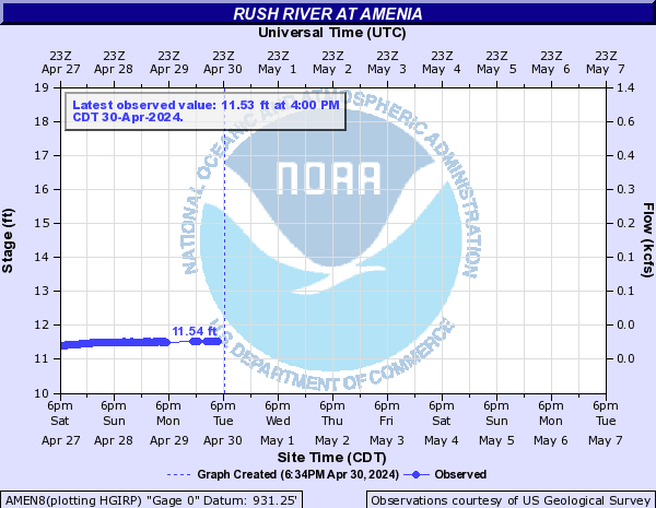
Rush River (Click on an image to go to hydrograph webpage)
AMEN8:
S. Fork Republican River (Click on an image to go to hydrograph webpage)
BEKN1:

Saint Vrain Creek (Click on an image to go to hydrograph webpage)
LNSC2:
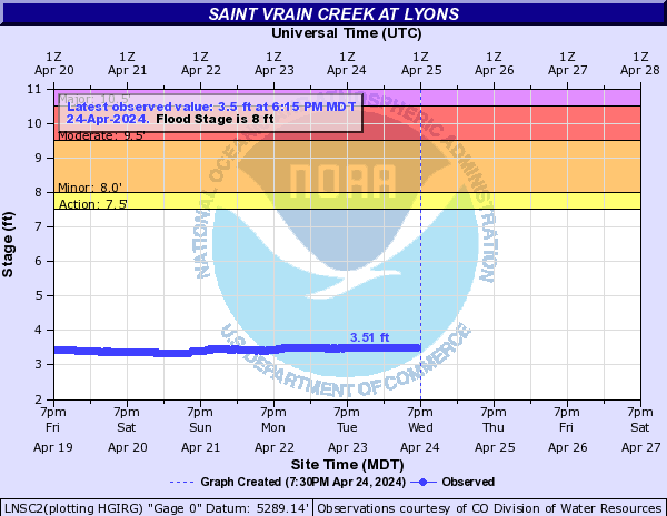
SVCC2:
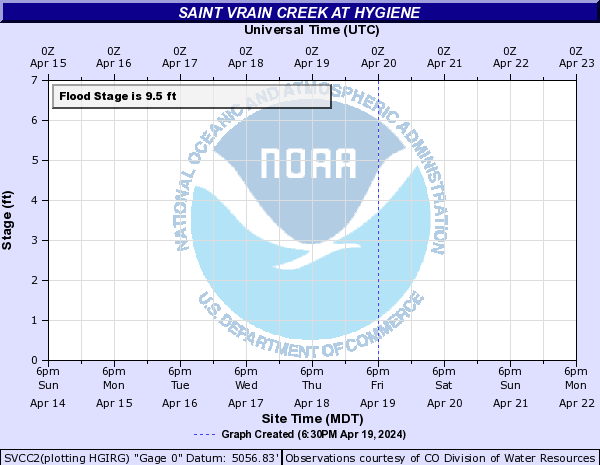
SVLC2:
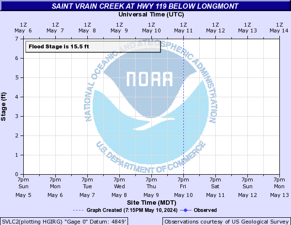
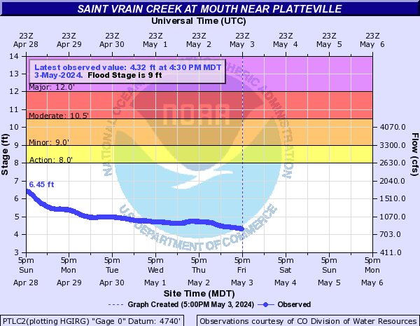
PTLC2: