Au Sable River (Click on an image to go to hydrograph webpage)
RDOM4:

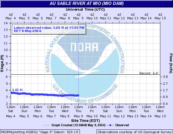
MIOM4:
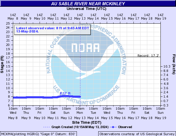
MCKM4:
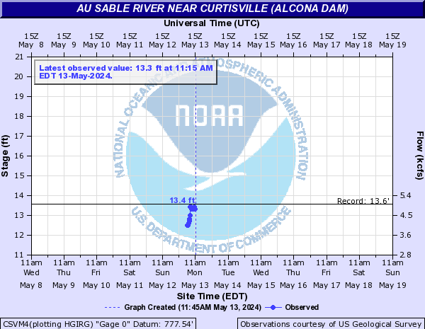
CSVM4:
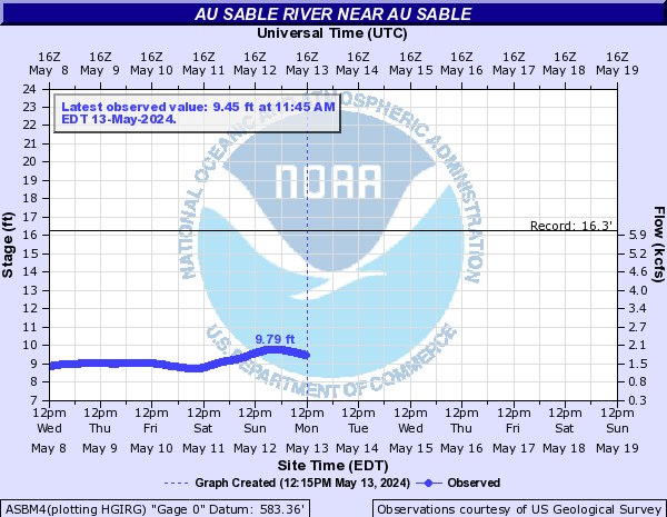
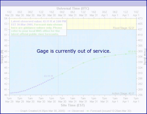
ASBM4:
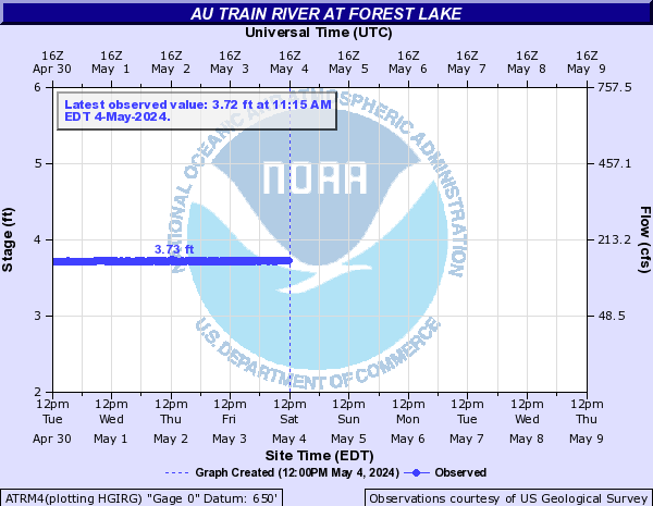
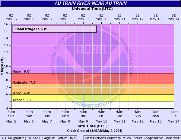
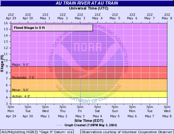
Au Train River (Click on an image to go to hydrograph webpage)
ATRM4:
AUTM4:
AULM4:
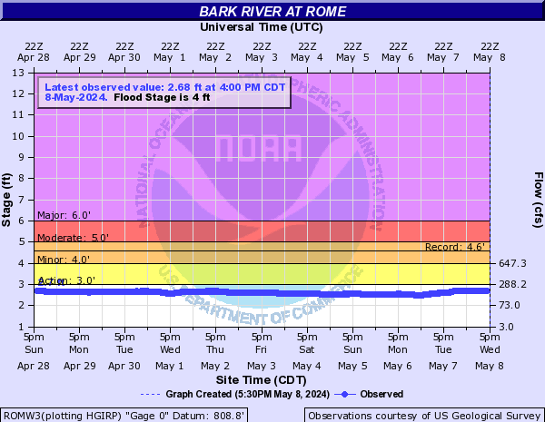
Bark River (Click on an image to go to hydrograph webpage)
ROMW3:
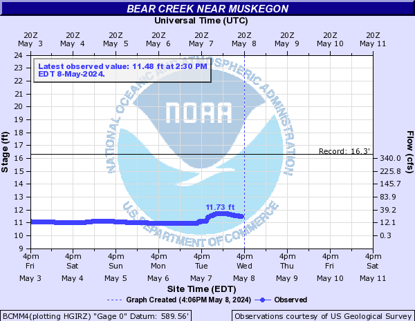
Bear Creek (Click on an image to go to hydrograph webpage)
BCMM4:
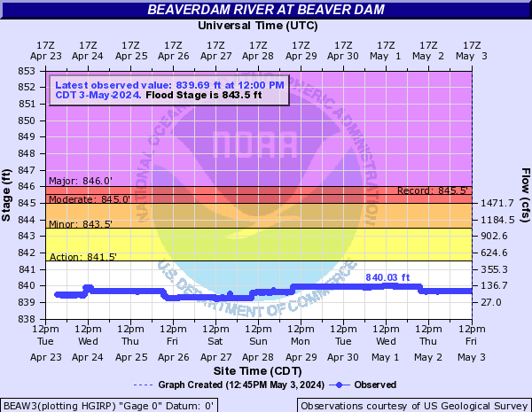
Beaverdam River (Click on an image to go to hydrograph webpage)
BEAW3:
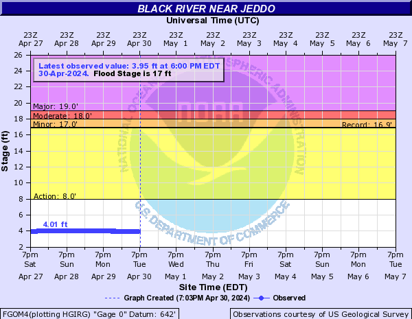
Black River (Click on an image to go to hydrograph webpage)
FGOM4:
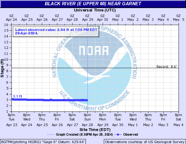
Black River (E Upper MI) (Click on an image to go to hydrograph webpage)
BGTM4:
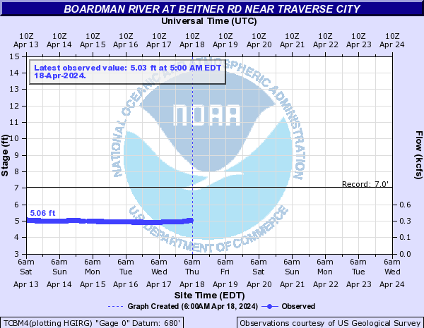
Boardman River (Click on an image to go to hydrograph webpage)
MYFM4:

TCBM4:
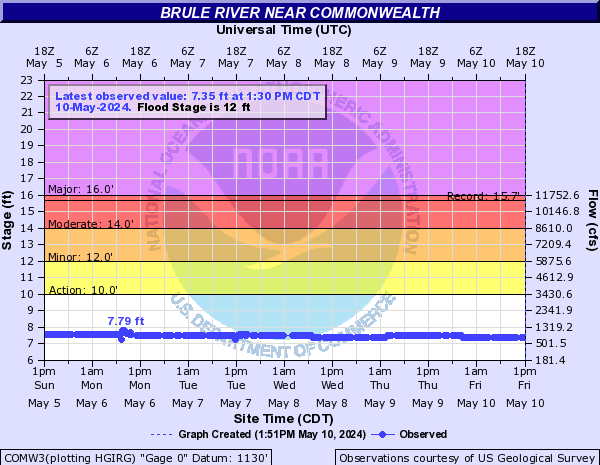
Brule River (Click on an image to go to hydrograph webpage)
FLRW3:

COMW3:
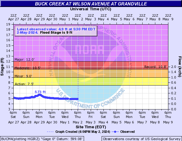
Buck Creek (Click on an image to go to hydrograph webpage)
BUCM4:
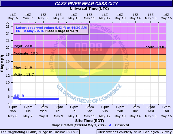
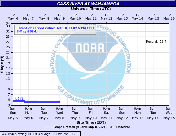
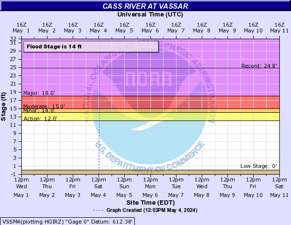
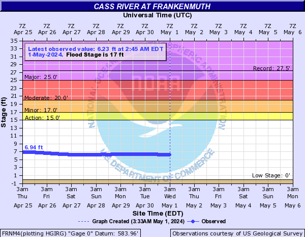
Cass River (Click on an image to go to hydrograph webpage)
CSSM4:
WAHM4:
VSSM4:
FRNM4:
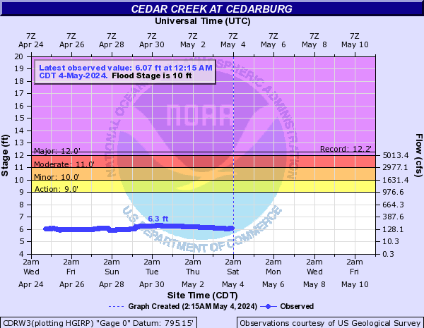
Cedar Creek (Click on an image to go to hydrograph webpage)
CDRW3:
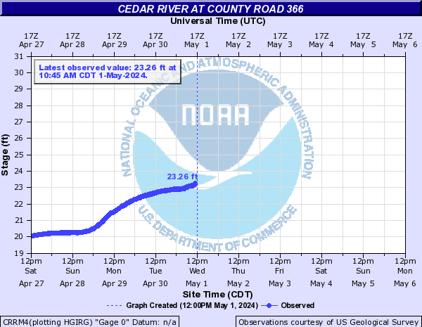
Cedar River (Click on an image to go to hydrograph webpage)
CRRM4:
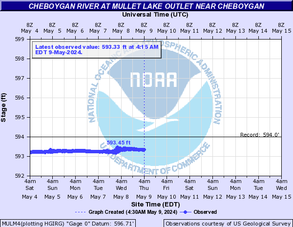
Cheboygan River (Click on an image to go to hydrograph webpage)
MULM4:
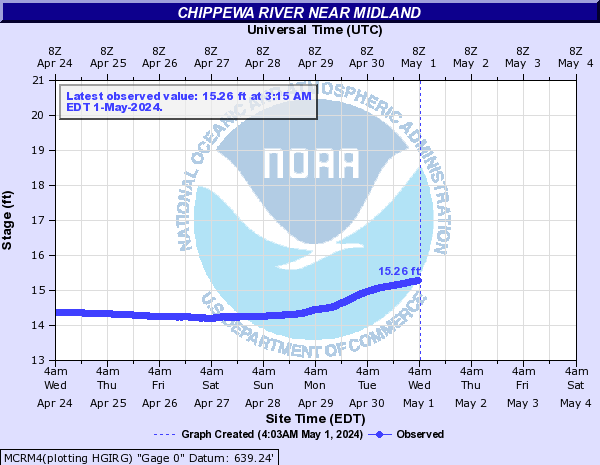
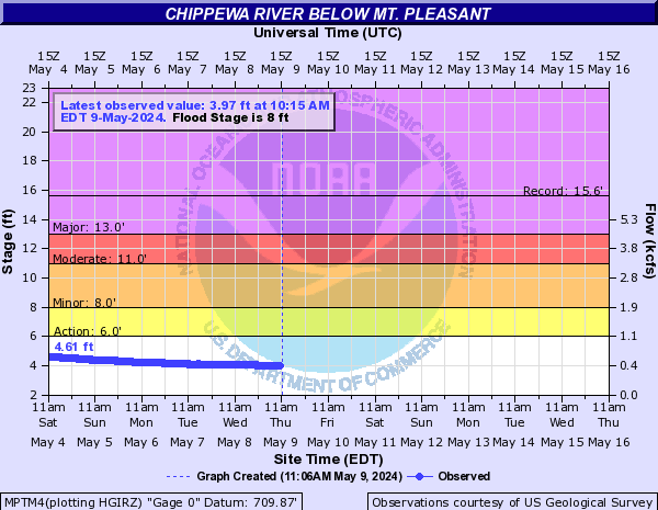
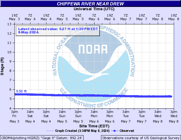
Chippewa River (Click on an image to go to hydrograph webpage)
MCRM4:
MPTM4:
CRDM4:
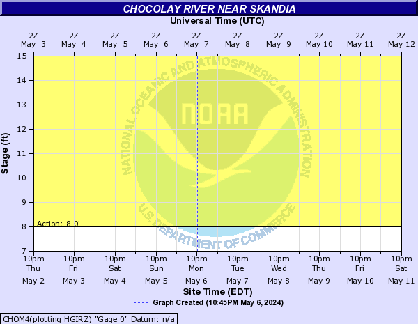
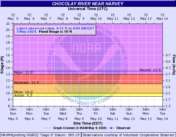
Chocolay River (Click on an image to go to hydrograph webpage)
CHOM4:
HRVM4:
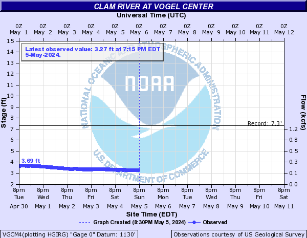
Clam River (Click on an image to go to hydrograph webpage)
VGCM4:
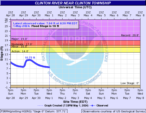
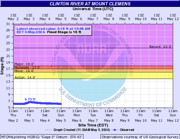
Clinton River (Click on an image to go to hydrograph webpage)
FSRM4:
MTCM4:
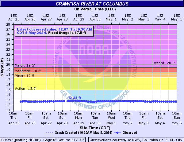
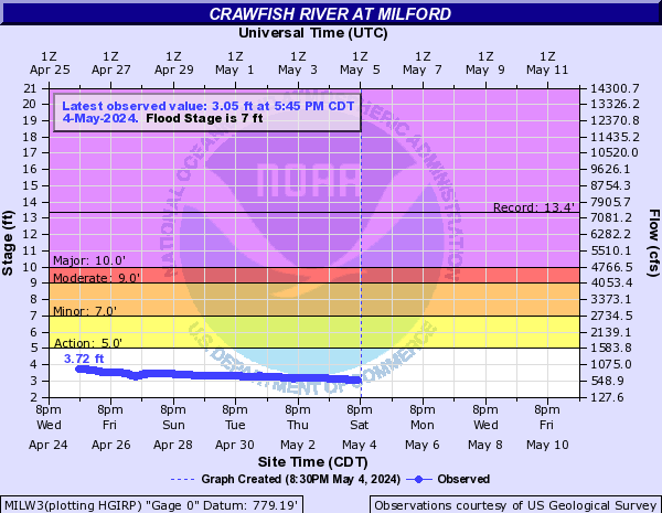
Crawfish River (Click on an image to go to hydrograph webpage)
CUSW3:
MILW3:
Dead River (Click on an image to go to hydrograph webpage)
DRMM4:

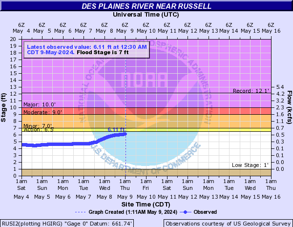
Des Plaines River (Click on an image to go to hydrograph webpage)
RUSI2:
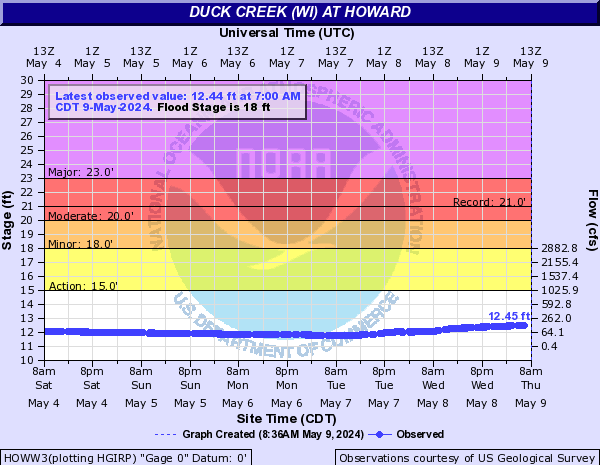
Duck Creek (WI) (Click on an image to go to hydrograph webpage)
HOWW3:
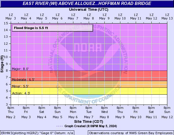
East River (WI) (Click on an image to go to hydrograph webpage)
GGGW3:

ERHW3:
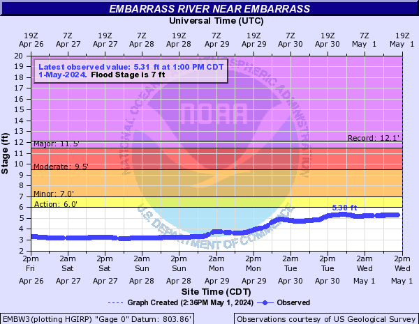
Embarrass River (Click on an image to go to hydrograph webpage)
EMBW3:
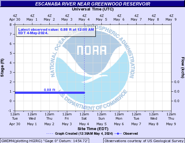
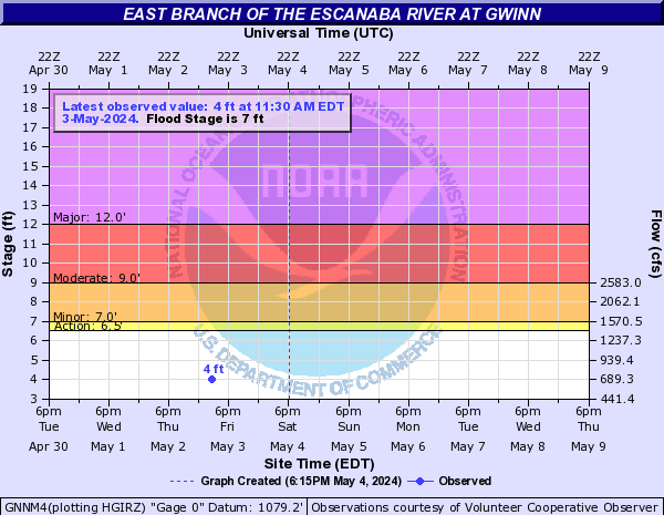
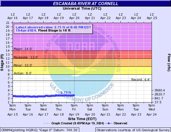
Escanaba River (Click on an image to go to hydrograph webpage)
GWDM4:
GNNM4:
CRNM4:
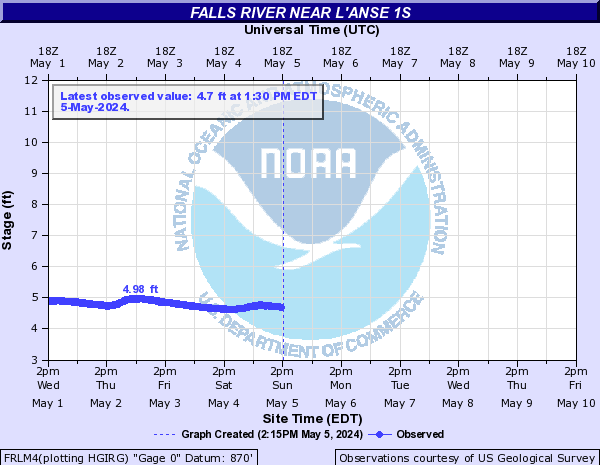
Falls River (Click on an image to go to hydrograph webpage)
FRLM4:
Fish Creek (Click on an image to go to hydrograph webpage)
FCRM4:

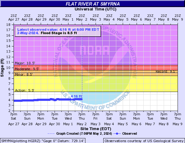
Flat River (Click on an image to go to hydrograph webpage)
SMYM4:
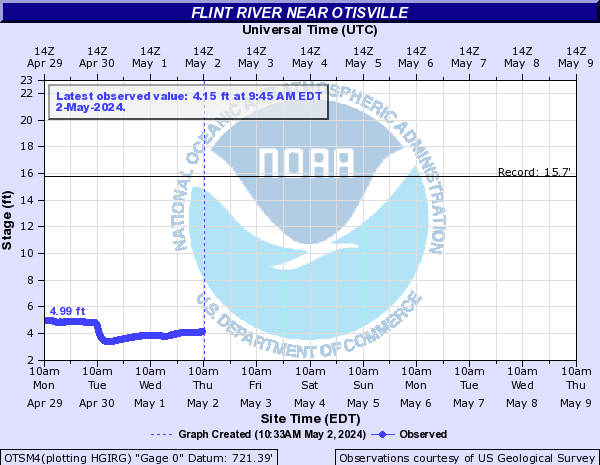
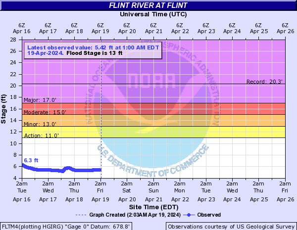
Flint River (Click on an image to go to hydrograph webpage)
OTSM4:
FLTM4:
FOSM4:

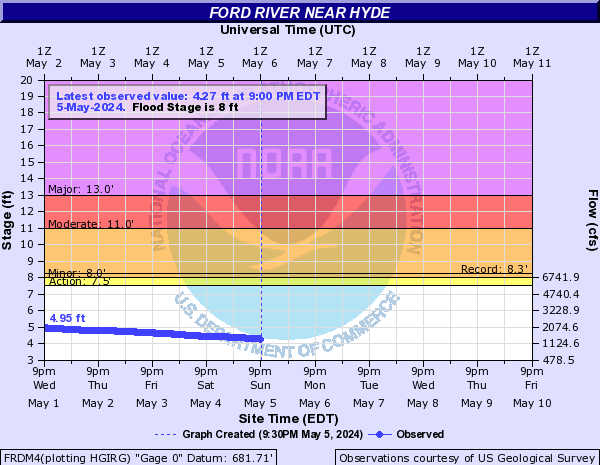
Ford River (Click on an image to go to hydrograph webpage)
FRDM4:
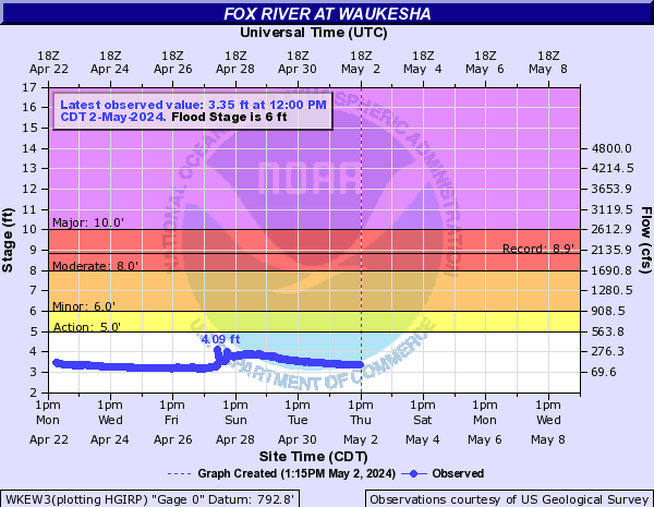
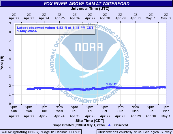
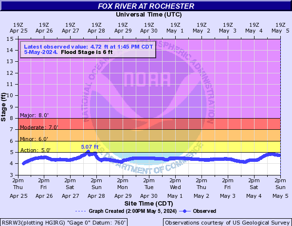
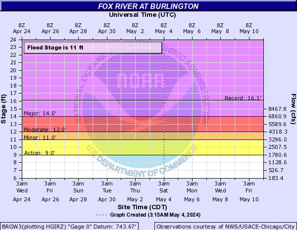
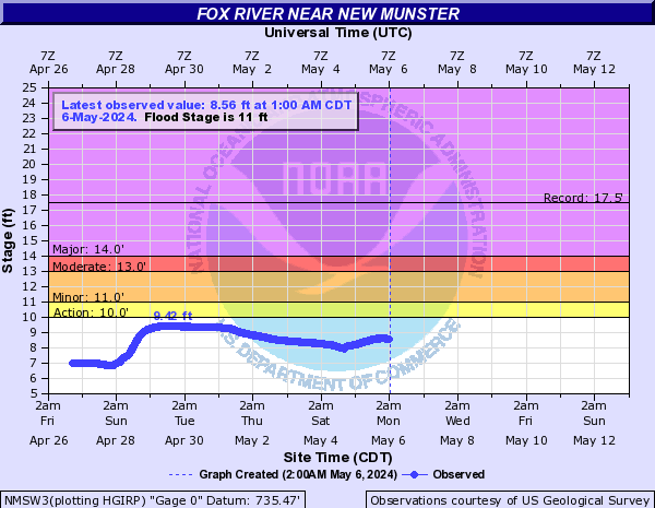
Fox River (Click on an image to go to hydrograph webpage)
WKEW3:
WADW3:
RSRW3:
BRGW3:
NMSW3:
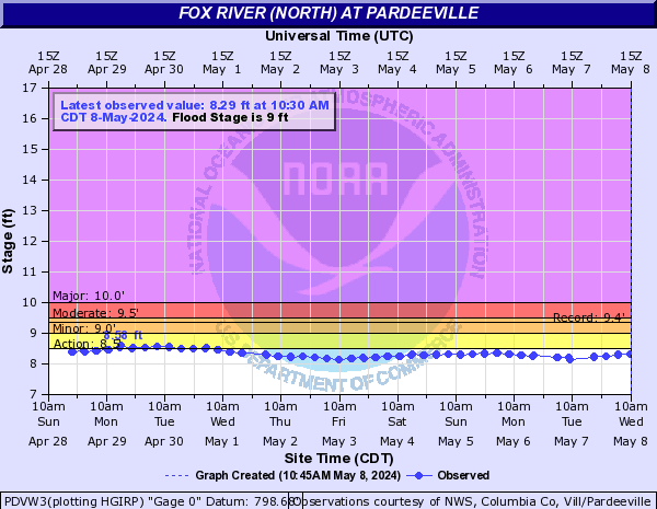
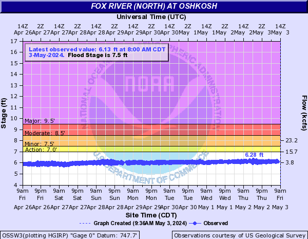
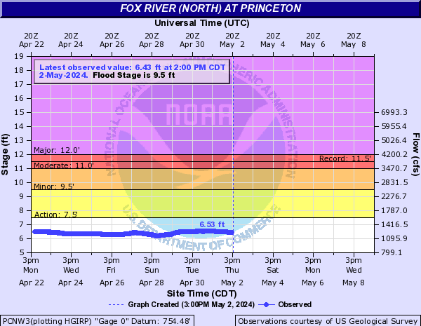
Fox River (North) (Click on an image to go to hydrograph webpage)
PDVW3:
OSSW3:
PCNW3:
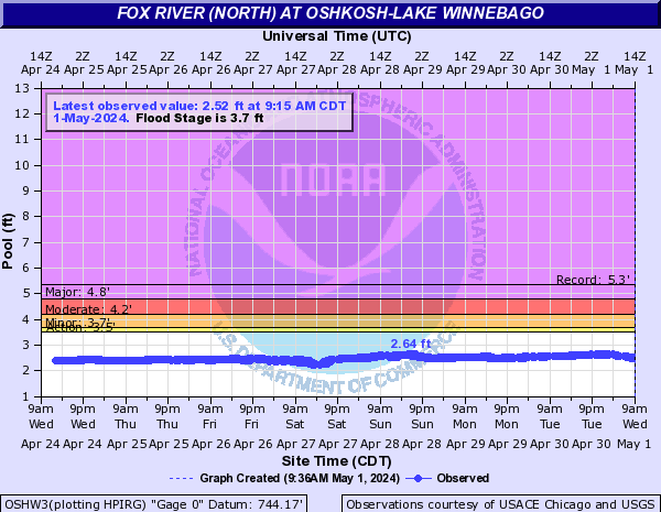
OSHW3:
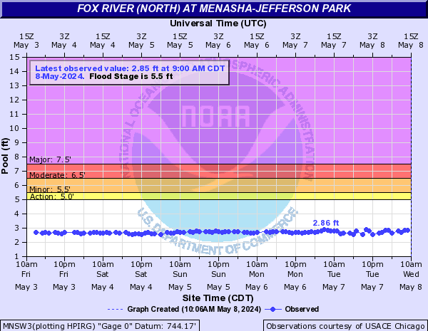
MNSW3:
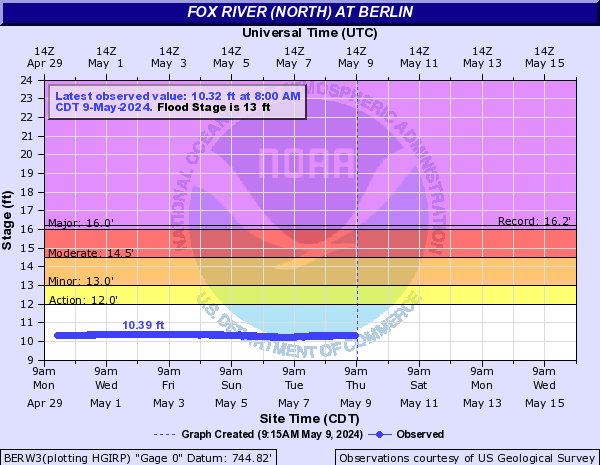
BERW3:
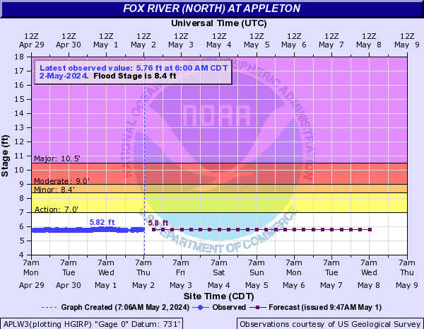
APLW3:
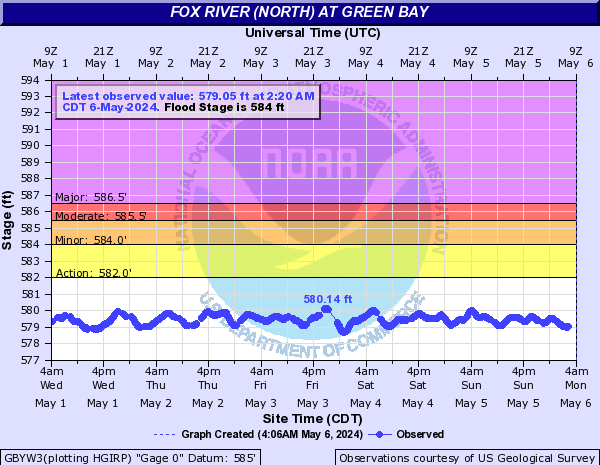
GBYW3:
WRGW3:

STKW3:

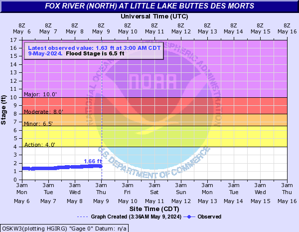
OSKW3:
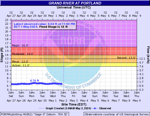
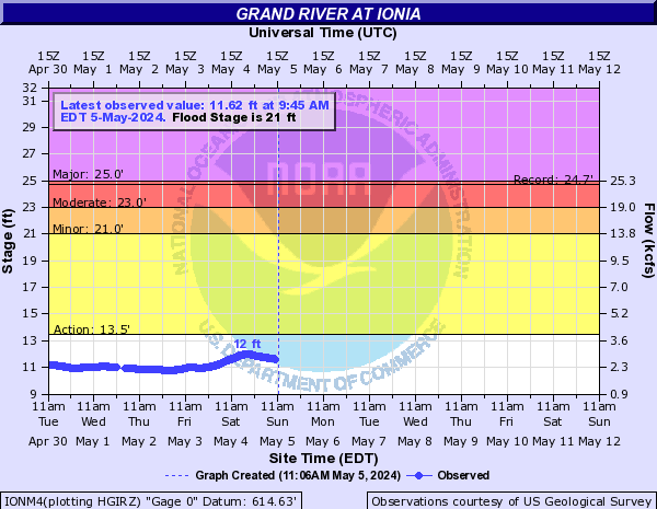
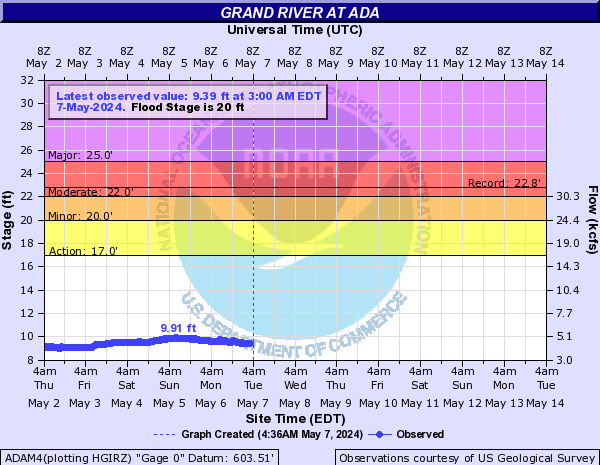
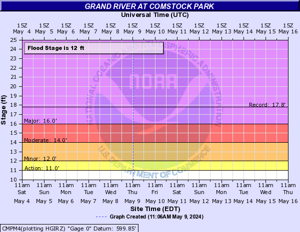
Grand River (Click on an image to go to hydrograph webpage)
EATM4:

ETNM4:

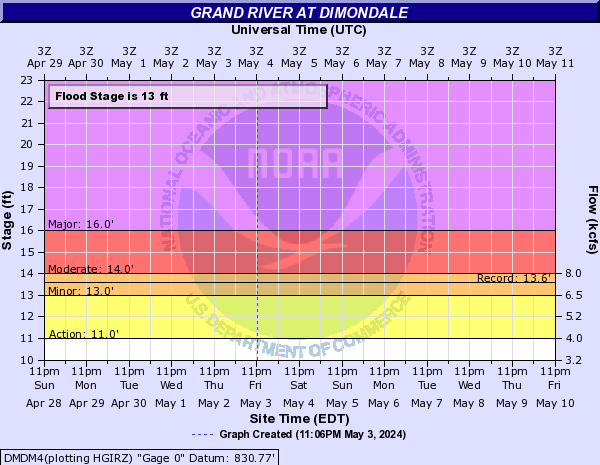
DMDM4:
LNSM4:

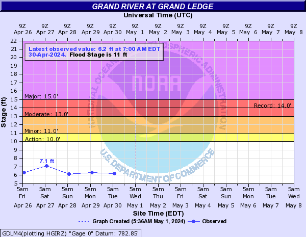
GDLM4:
PORM4:
IONM4:
LWLM4:

ADAM4:
CMPM4:
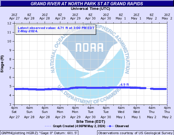
GNPM4:
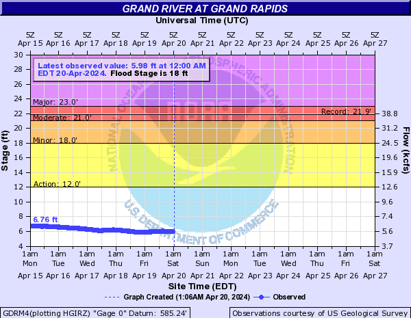
GDRM4:
GNDM4:

EASM4:

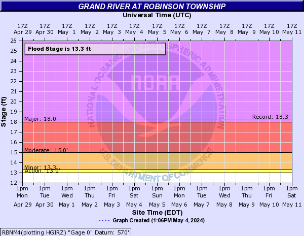
RBNM4:
Huron River (Click on an image to go to hydrograph webpage)
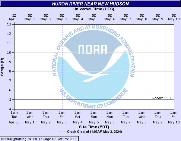
NHHM4:
MFHM4:
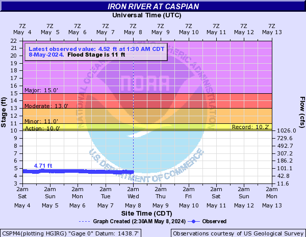
Iron River (Click on an image to go to hydrograph webpage)
CSPM4:
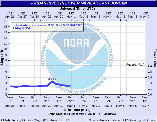
Jordan River (N Lower MI) (Click on an image to go to hydrograph webpage)
EJJM4:
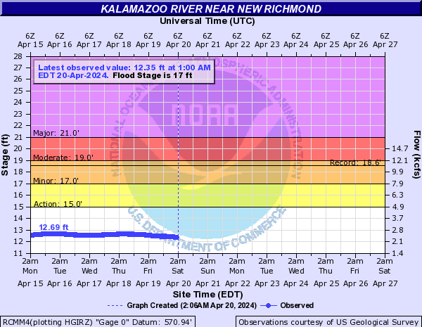
Kalamazoo River (Click on an image to go to hydrograph webpage)
RCMM4:
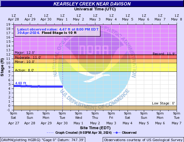
Kearsley Creek (Click on an image to go to hydrograph webpage)
DAVM4:
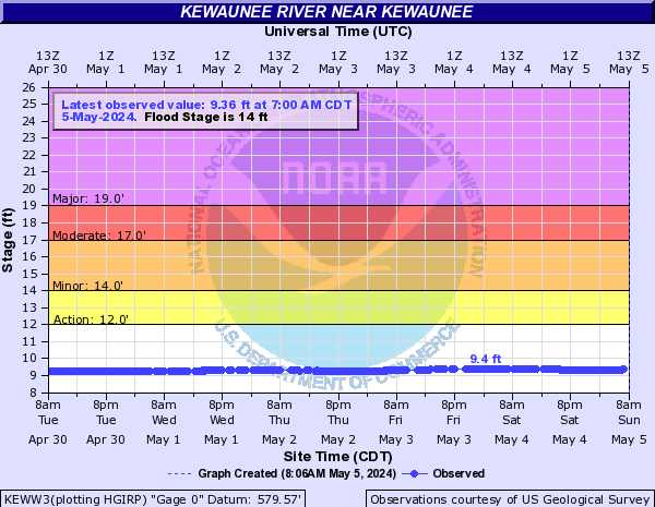
Kewaunee River (Click on an image to go to hydrograph webpage)
KEWW3:
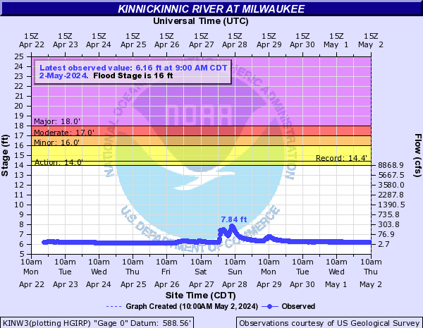
Kinnickinnic River (Click on an image to go to hydrograph webpage)
KINW3:
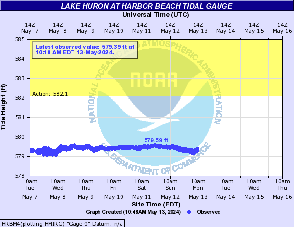
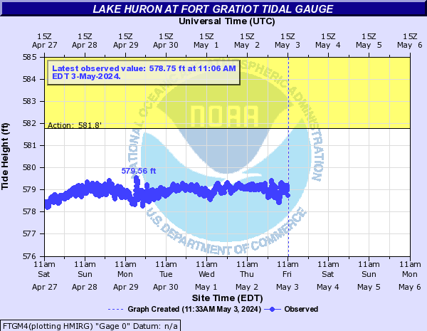
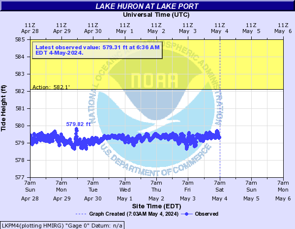
Lake Huron (Click on an image to go to hydrograph webpage)
HRBM4:
FTGM4:
LKPM4:
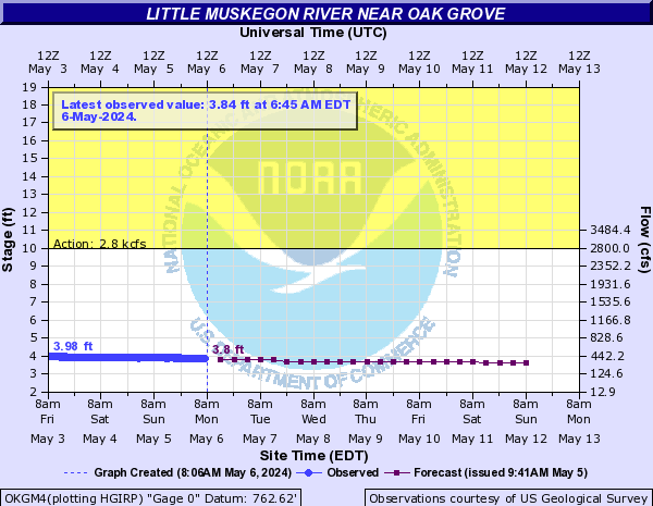
Little Muskegon River (Click on an image to go to hydrograph webpage)
MORM4:

OKGM4:
Little Wolf River (Click on an image to go to hydrograph webpage)
ROYW3:

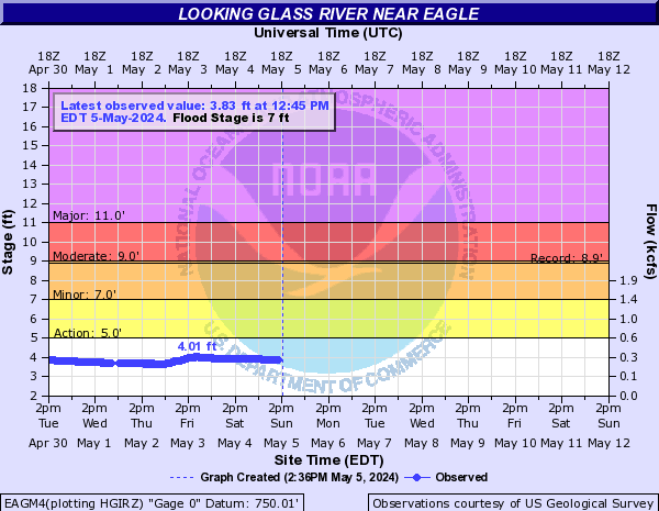
Looking Glass River (Click on an image to go to hydrograph webpage)
EAGM4:
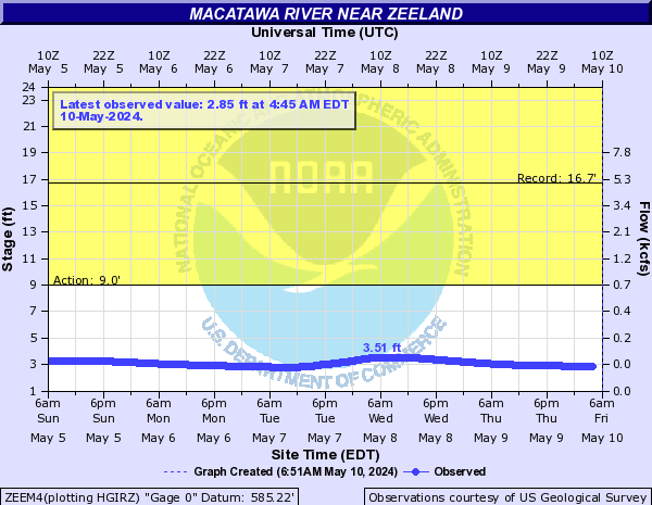
Macatawa River (Click on an image to go to hydrograph webpage)
ZEEM4:
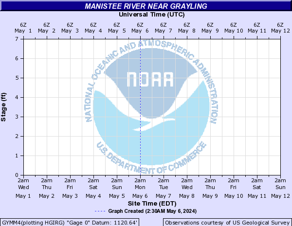
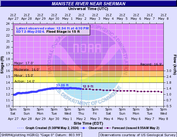
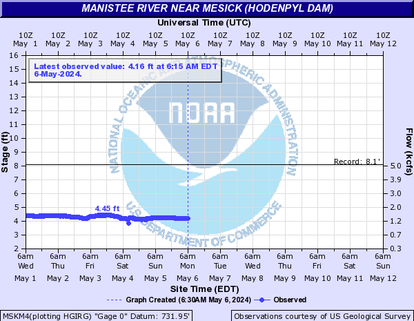
Manistee River (Click on an image to go to hydrograph webpage)
GYMM4:
SHRM4:
MSKM4:
WLSM4:

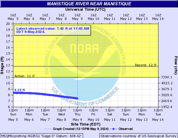
Manistique River (Click on an image to go to hydrograph webpage)
MSQM4:
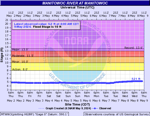
Manitowoc River (Click on an image to go to hydrograph webpage)
MTWW3:
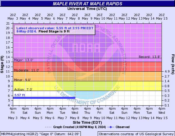
Maple River (Click on an image to go to hydrograph webpage)
MRPM4:
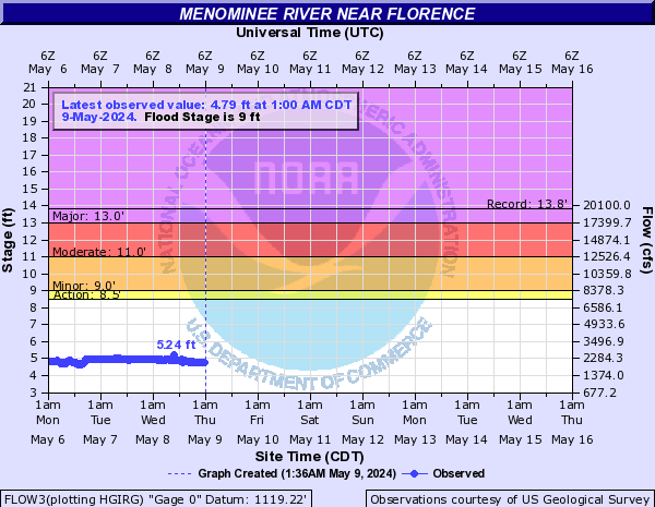
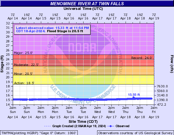
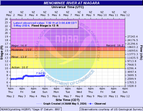
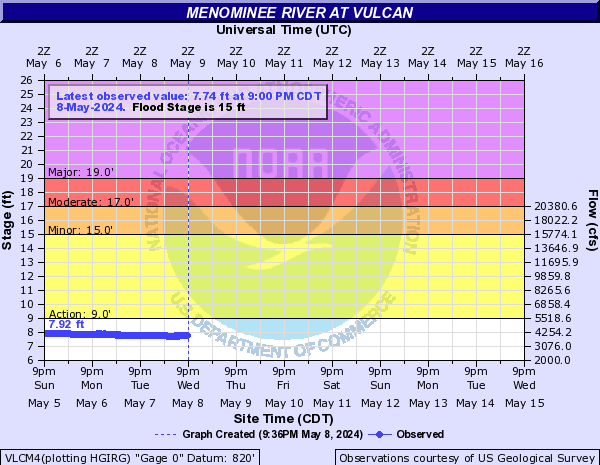
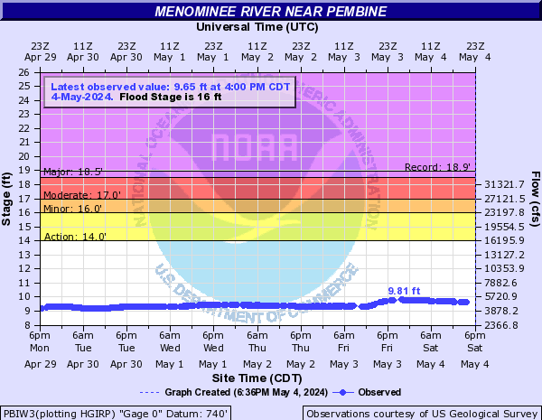
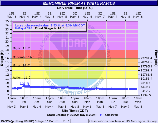
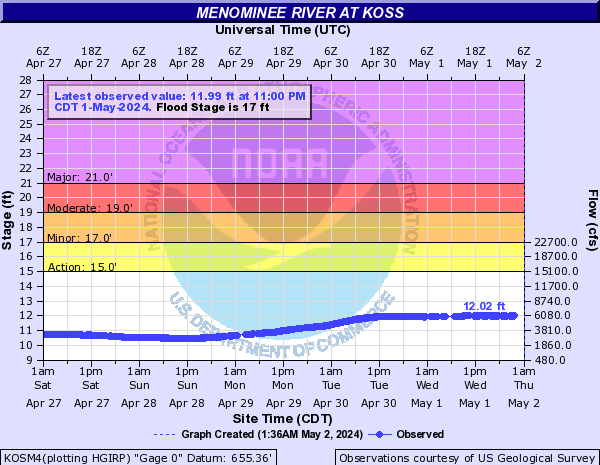
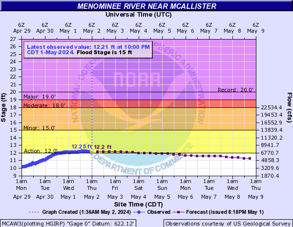
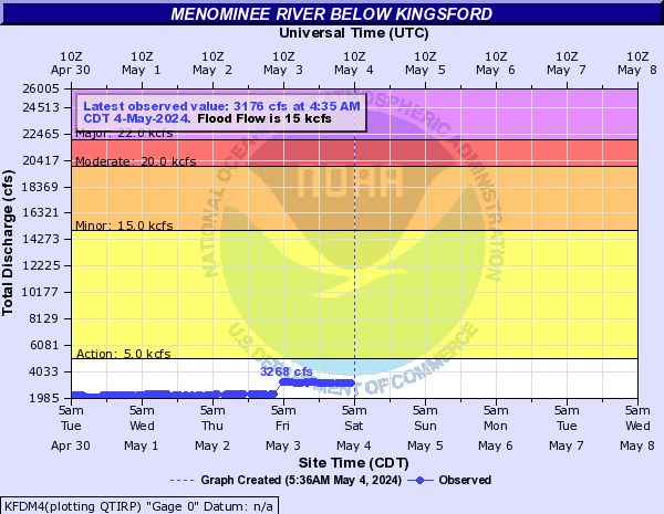
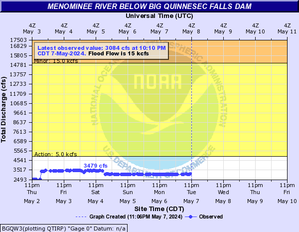
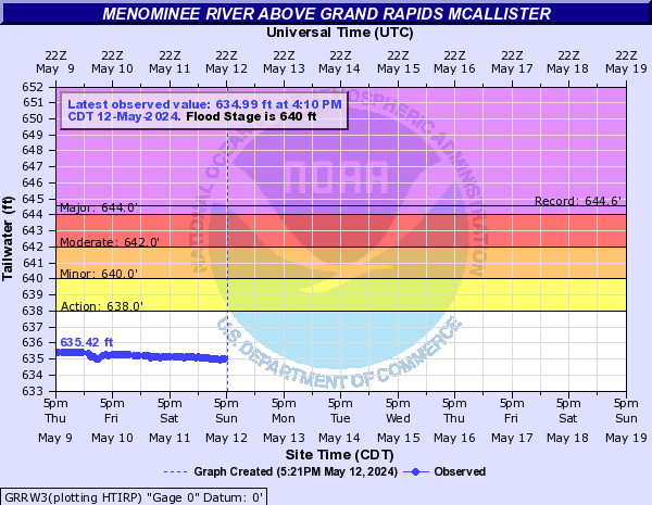
Menominee River (Click on an image to go to hydrograph webpage)
FLOW3:
TWFM4:
NIAW3:
VLCM4:
PBIW3:
BANM4:
KOSM4:
MCAW3:
KFDM4:
BGQW3:
GRRW3:
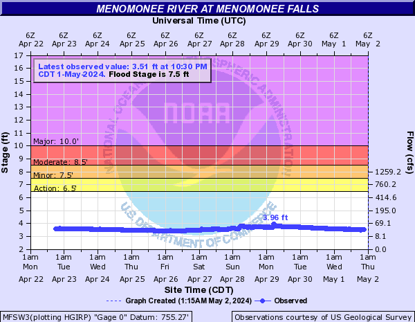
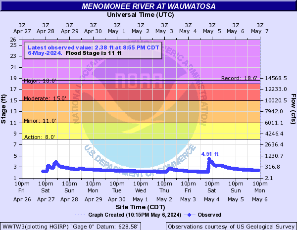
Menomonee River (Click on an image to go to hydrograph webpage)
MFSW3:
WWTW3:
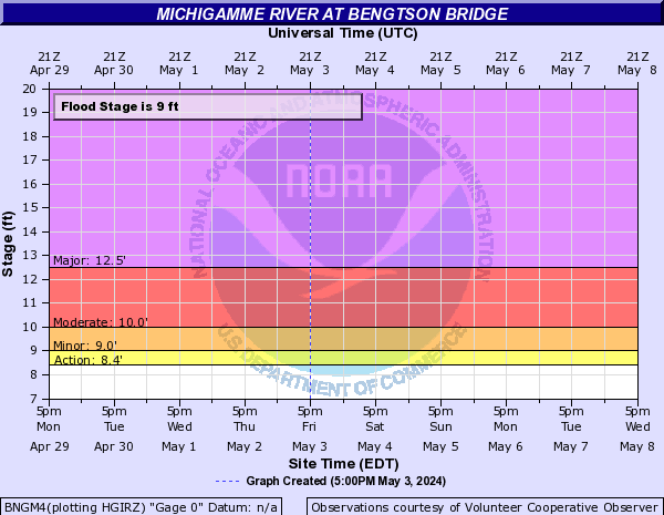
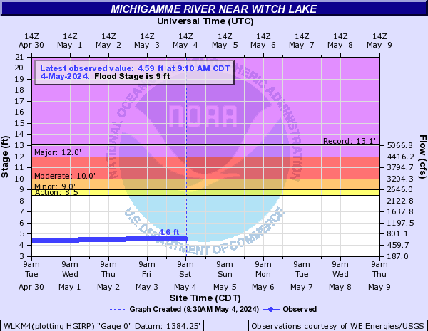
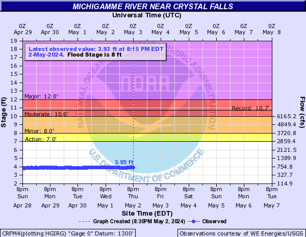
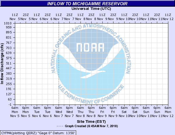
Michigamme River (Click on an image to go to hydrograph webpage)
BNGM4:
WLKM4:
CRFM4:
CYFM4:
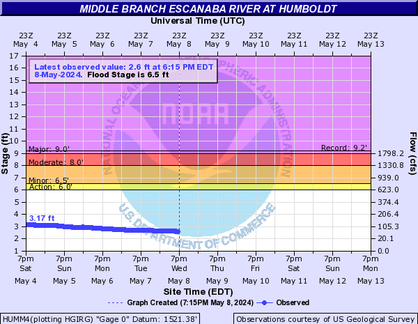
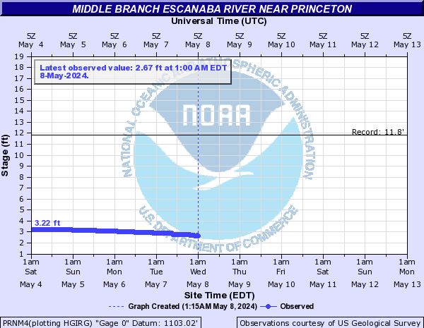
Middle Branch Escanaba River (Click on an image to go to hydrograph webpage)
HUMM4:
PRNM4:
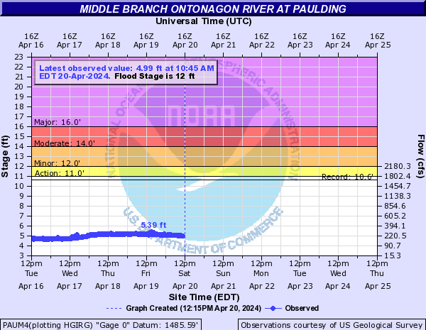
Middle Branch Ontonagon River (Click on an image to go to hydrograph webpage)
PAUM4:
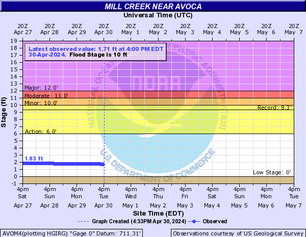
Mill Creek (Click on an image to go to hydrograph webpage)
AVOM4:
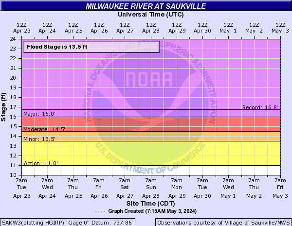
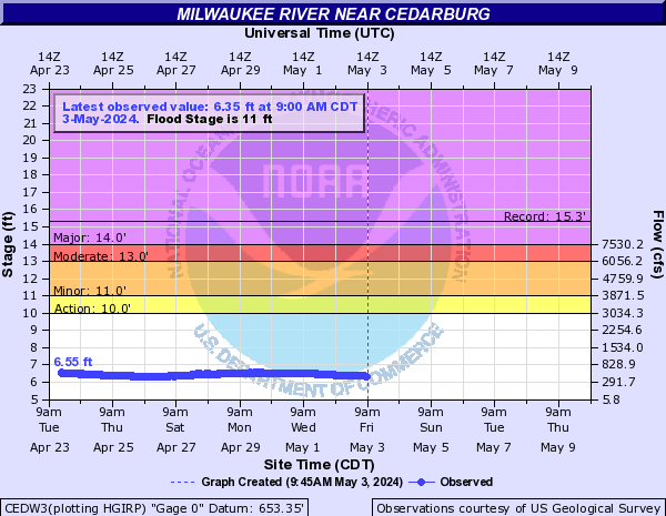
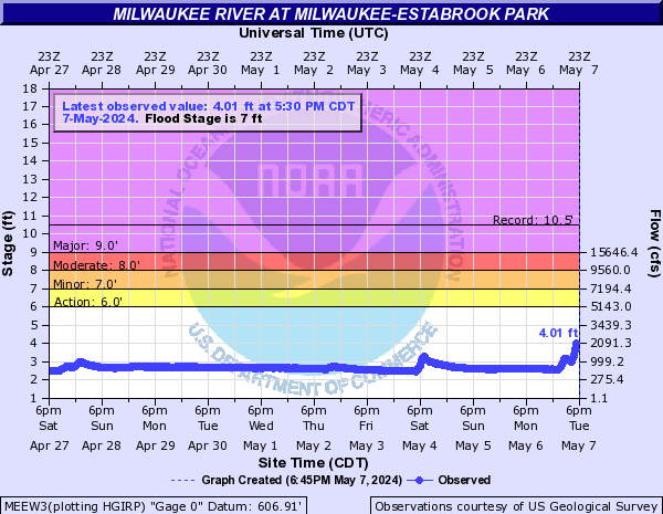
Milwaukee River (Click on an image to go to hydrograph webpage)
WAUW3:

SAKW3:
CEDW3:
MEEW3:
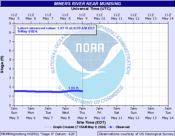
Miners River (Click on an image to go to hydrograph webpage)
MRMM4:
Mukwonago River (Click on an image to go to hydrograph webpage)
MUKW3:

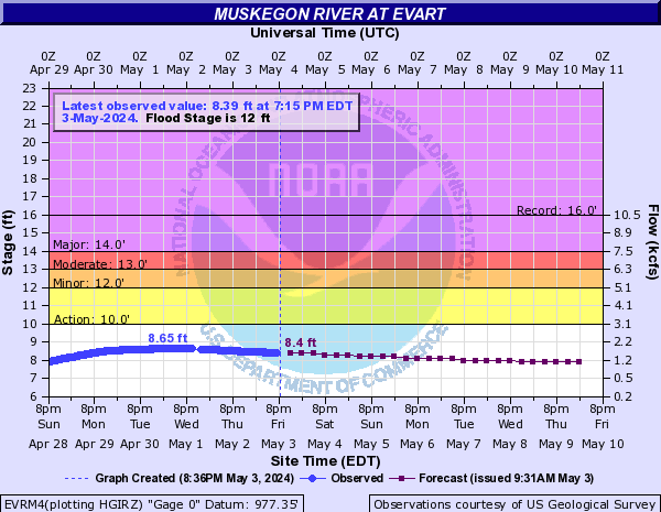
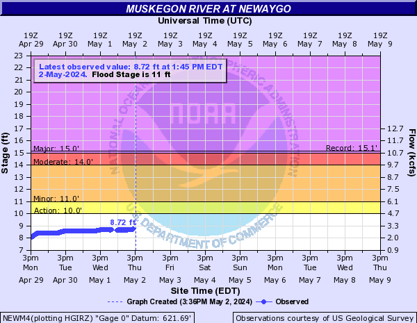
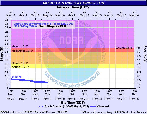
Muskegon River (Click on an image to go to hydrograph webpage)
EVRM4:
CROM4:

NEWM4:
BDGM4:
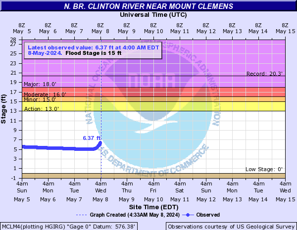
N. Br. Clinton River (Click on an image to go to hydrograph webpage)
MCLM4:
North Branch Au Sable River (Click on an image to go to hydrograph webpage)
KBLM4:

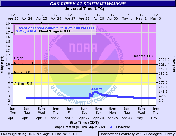
Oak Creek (Click on an image to go to hydrograph webpage)
OAKW3:
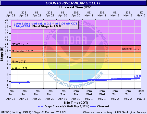
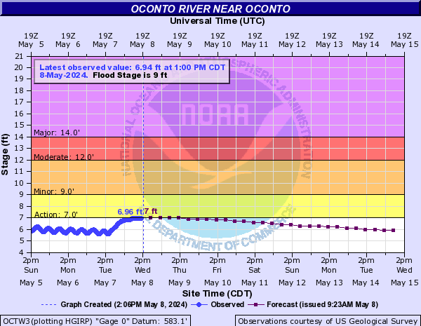
Oconto River (Click on an image to go to hydrograph webpage)
GILW3:
OCTW3:
Ontonagon River (Click on an image to go to hydrograph webpage)
RKLM4:

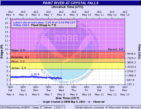
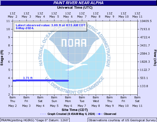
Paint River (Click on an image to go to hydrograph webpage)
CRYM4:
PRAM4:
Pere Marquette River (Click on an image to go to hydrograph webpage)
SCTM4:

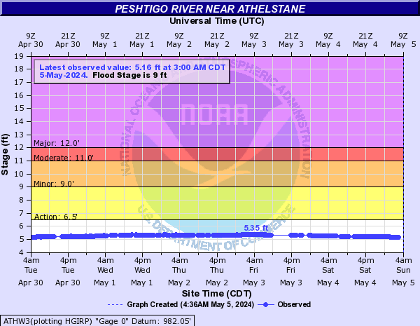
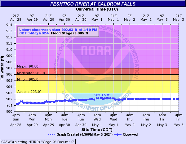
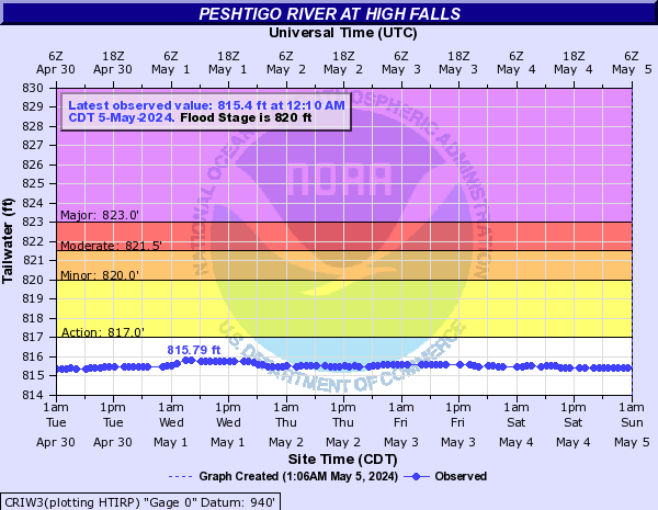
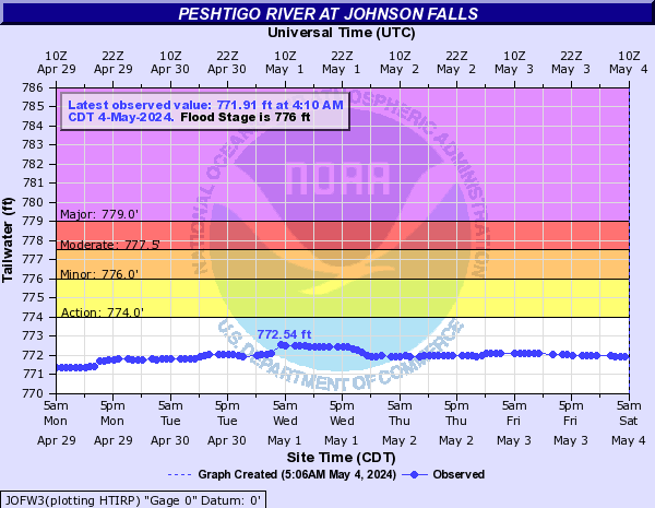
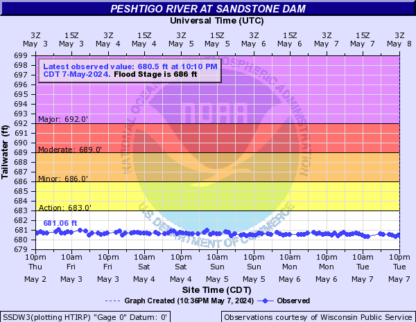
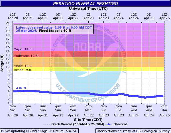
Peshtigo River (Click on an image to go to hydrograph webpage)
ATHW3:
CAFW3:
CRIW3:
JOFW3:
SSDW3:
PFDW3:

PESW3:
Pigeon River (N Lower MI) (Click on an image to go to hydrograph webpage)
SVRM4:

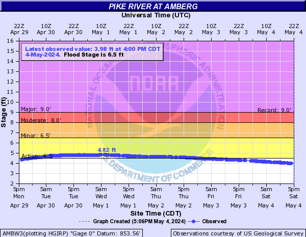
Pike River (Click on an image to go to hydrograph webpage)
AMBW3:
Pilgrim River (Click on an image to go to hydrograph webpage)
PLGM4:

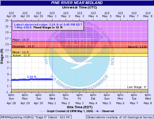
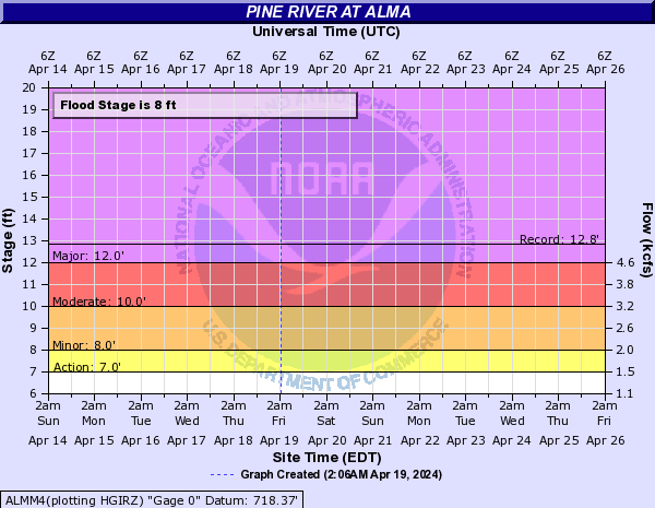
Pine River (Click on an image to go to hydrograph webpage)
MPRM4:
ALMM4:
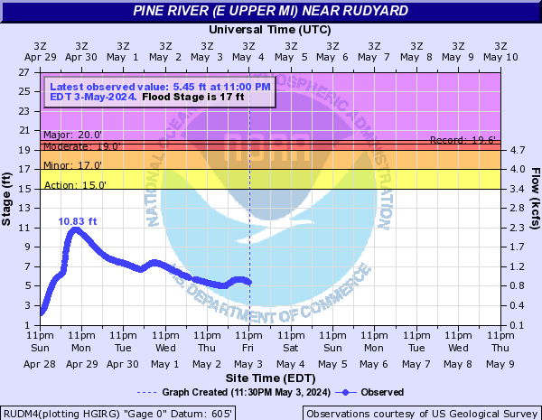
Pine River (E Upper MI) (Click on an image to go to hydrograph webpage)
RUDM4:
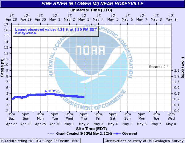
Pine River (N Lower MI) (Click on an image to go to hydrograph webpage)
HOXM4:
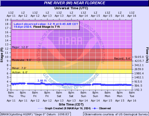
Pine River (WI) (Click on an image to go to hydrograph webpage)
BRKW3:
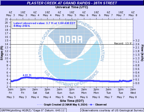
Plaster Creek (Click on an image to go to hydrograph webpage)
GRPM4:
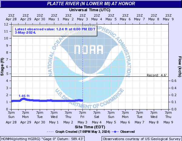
Platte River (N Lower MI) (Click on an image to go to hydrograph webpage)
HONM4:
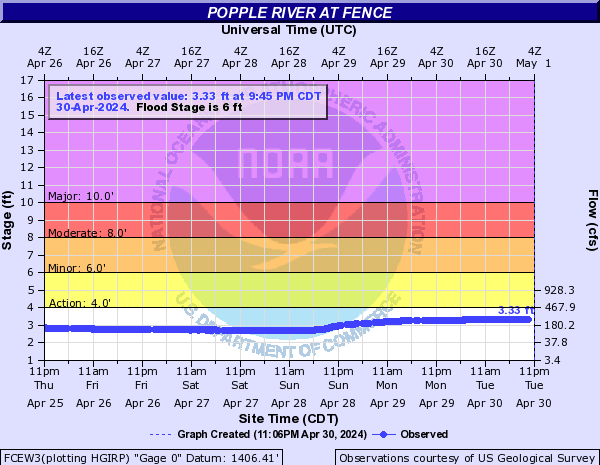
Popple River (Click on an image to go to hydrograph webpage)
FCEW3:
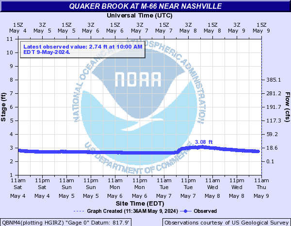
Quaker Brook (Click on an image to go to hydrograph webpage)
QBNM4:
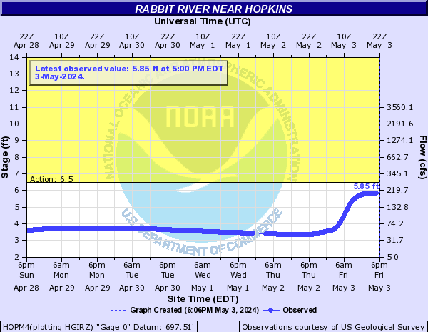
Rabbit River (Click on an image to go to hydrograph webpage)
HOPM4:
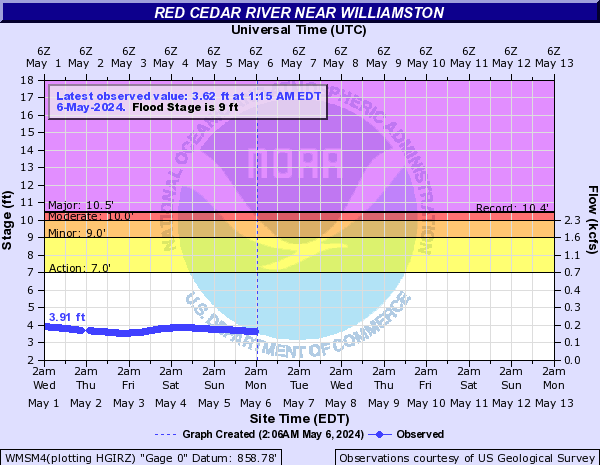
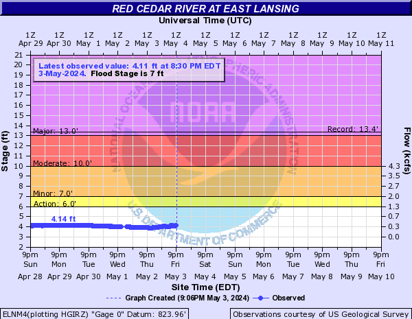
Red Cedar River (Click on an image to go to hydrograph webpage)
WMSM4:
ELNM4:
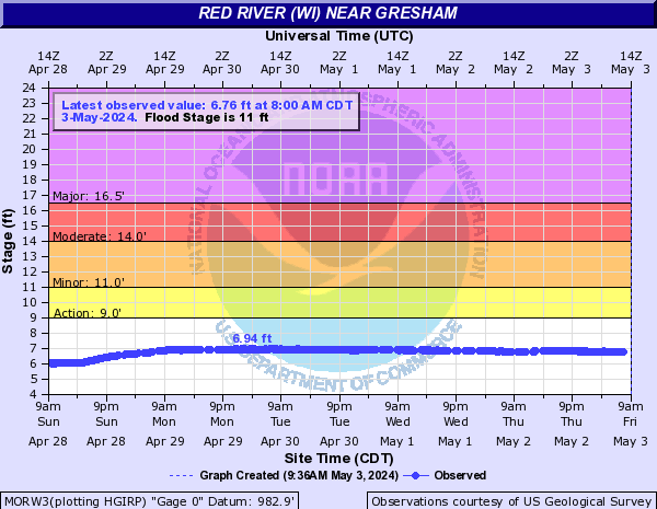
Red River (WI) (Click on an image to go to hydrograph webpage)
MORW3:
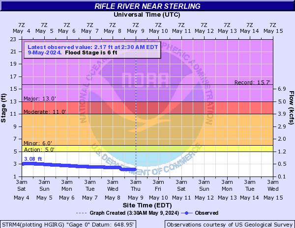
Rifle River (Click on an image to go to hydrograph webpage)
STRM4:
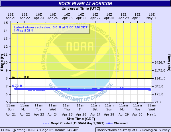
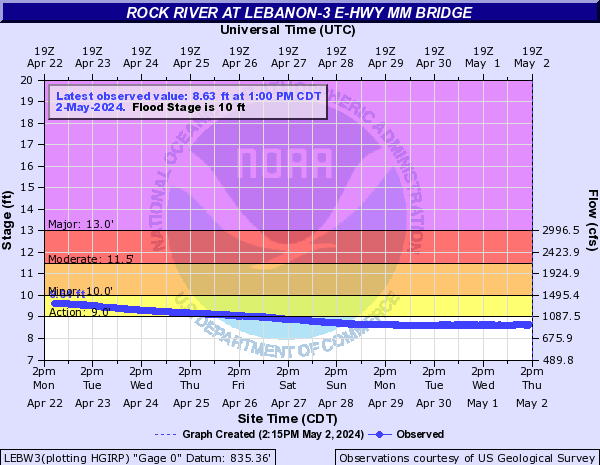
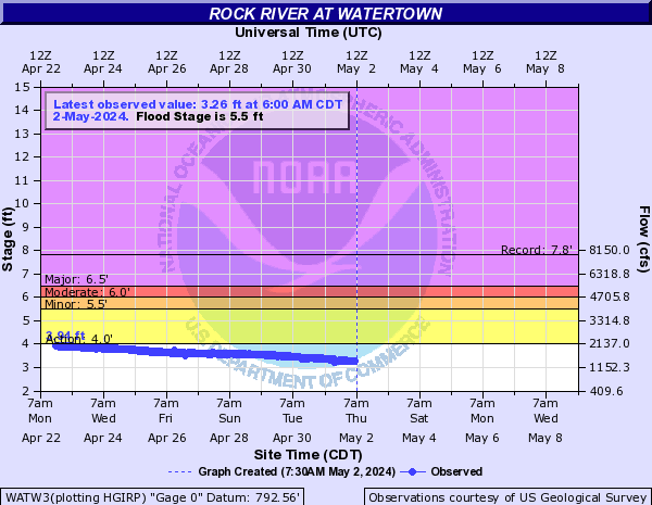
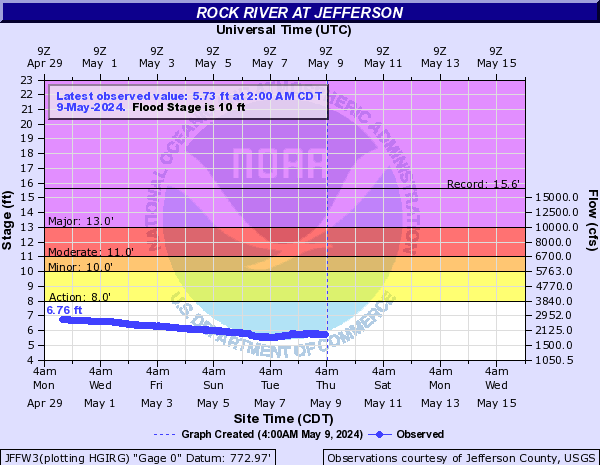
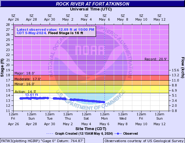
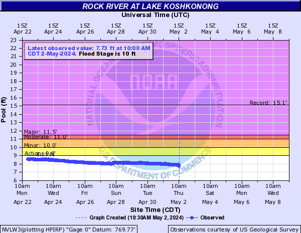
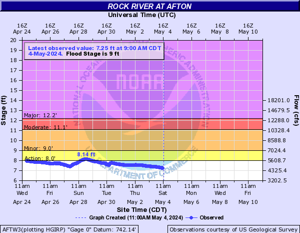
Rock River (Click on an image to go to hydrograph webpage)
HCNW3:
HDMW3:
LEBW3:
WATW3:
JFFW3:
FATW3:
NVLW3:
NVEW3:

AFTW3:
NVIW3:

Rogue River (Click on an image to go to hydrograph webpage)
ROCM4:

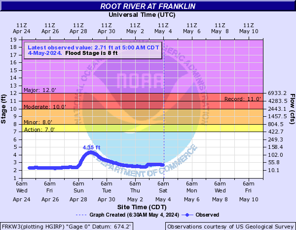
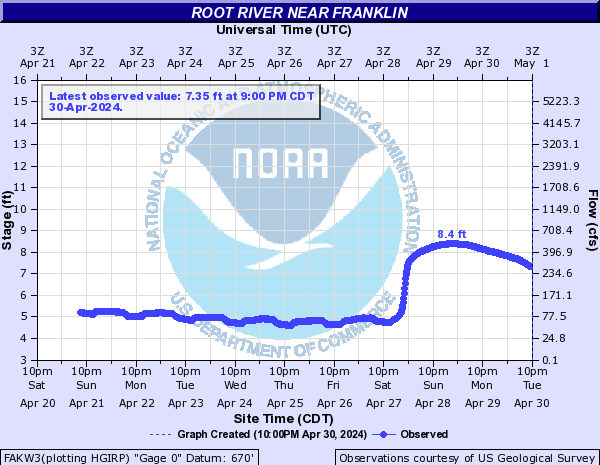
Root River (Click on an image to go to hydrograph webpage)
FRKW3:
RACW3:

FAKW3:
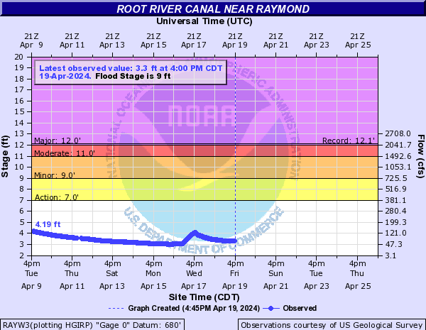
Root River Canal (Click on an image to go to hydrograph webpage)
RAYW3:
Rouge River (Click on an image to go to hydrograph webpage)
BHRM4:
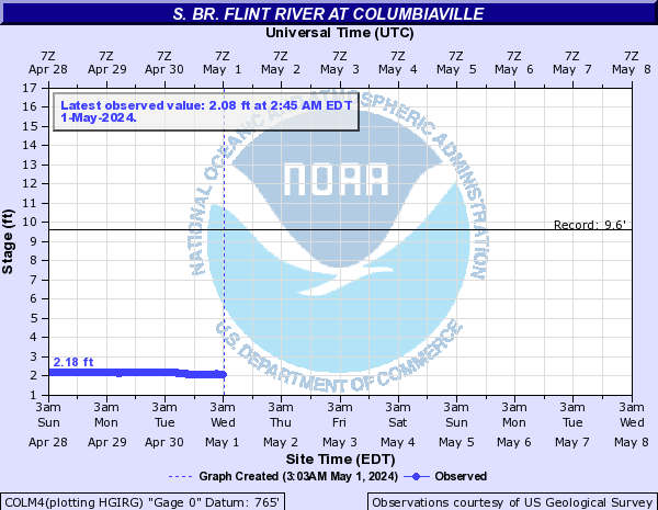
S. Br. Flint River (Click on an image to go to hydrograph webpage)
COLM4:
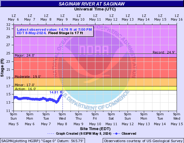
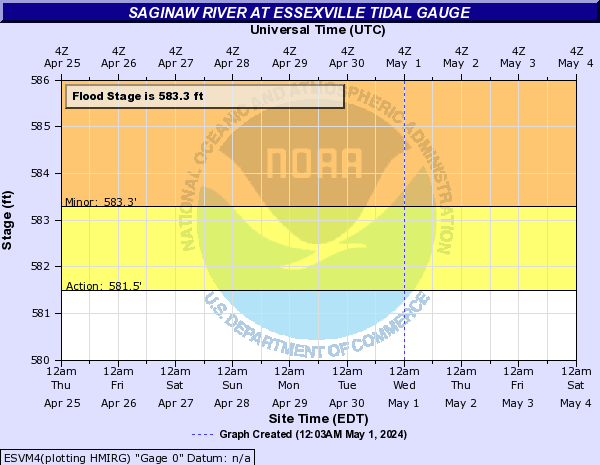
Saginaw River (Click on an image to go to hydrograph webpage)
SAGM4:
ESVM4:
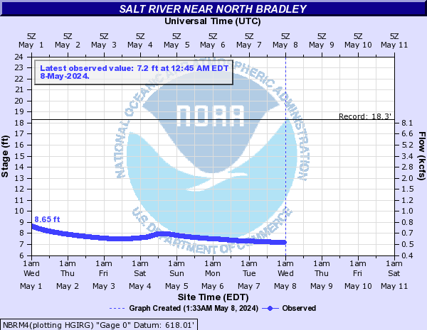
Salt River (Click on an image to go to hydrograph webpage)
NBRM4:
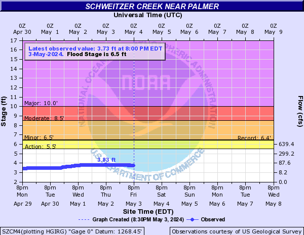
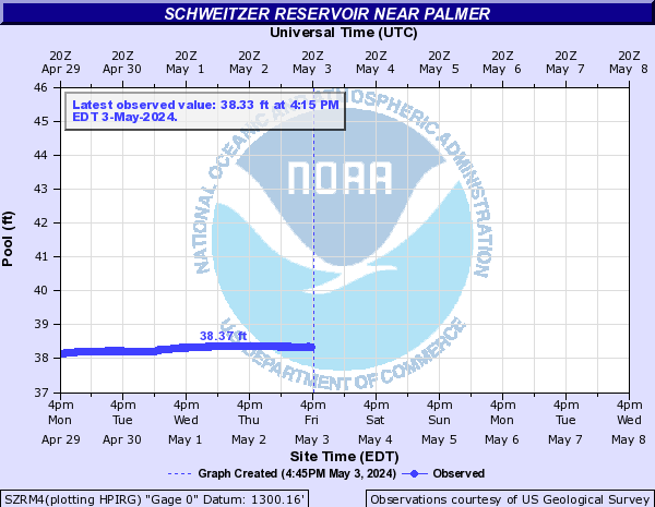
Schweitzer Creek (Click on an image to go to hydrograph webpage)
SZCM4:
SZRM4:
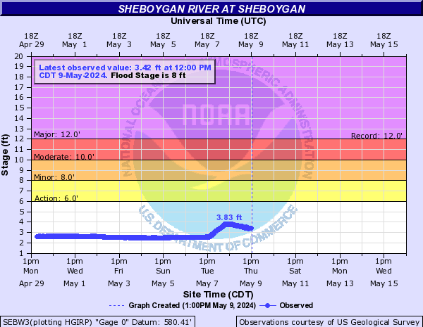
Sheboygan River (Click on an image to go to hydrograph webpage)
SEBW3:
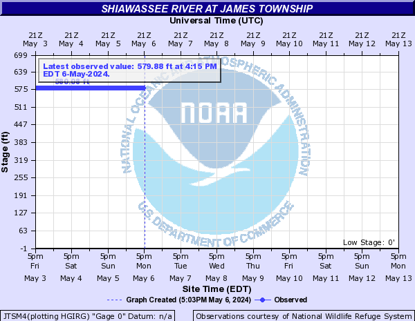
Shiawassee River (Click on an image to go to hydrograph webpage)
OWOM4:

JTSM4:
FRGM4:

CHSM4:

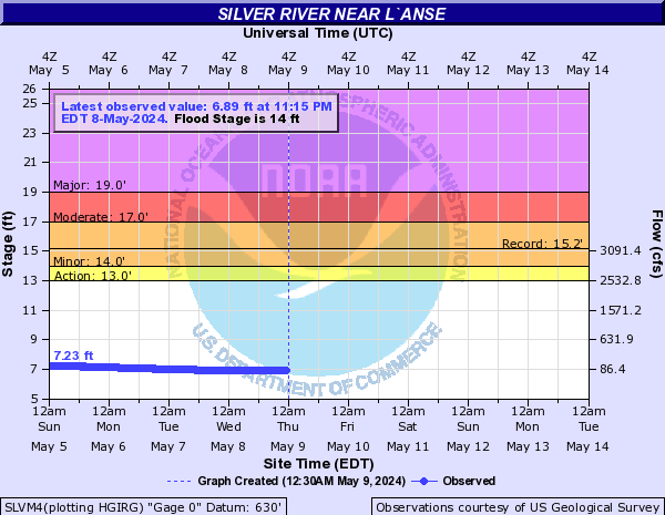
Silver River (Click on an image to go to hydrograph webpage)
SLVM4:
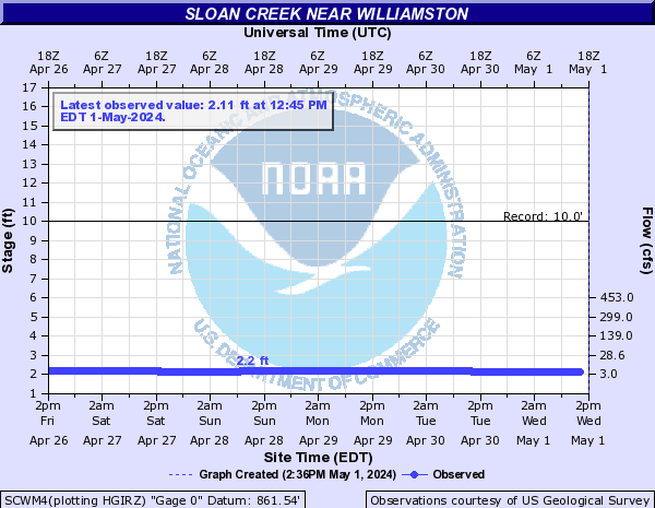
Sloan Creek (Click on an image to go to hydrograph webpage)
SCWM4:
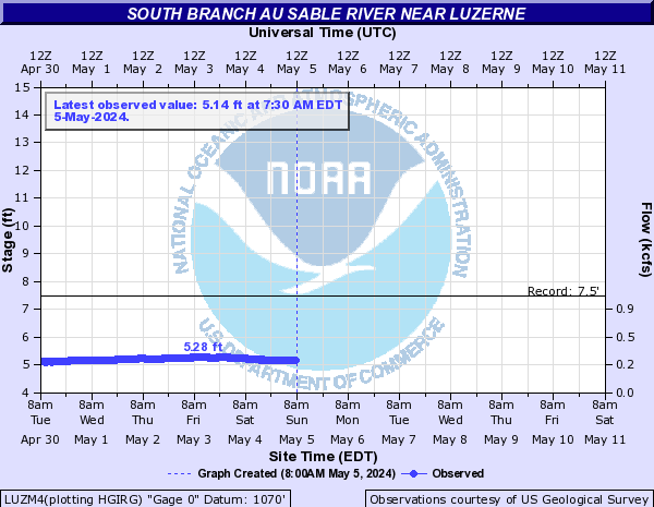
South Branch Au Sable River (Click on an image to go to hydrograph webpage)
LUZM4:
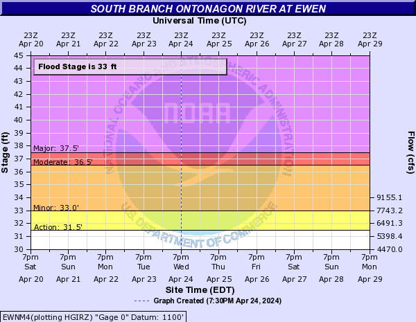
South Branch Ontonagon (Click on an image to go to hydrograph webpage)
EWNM4:
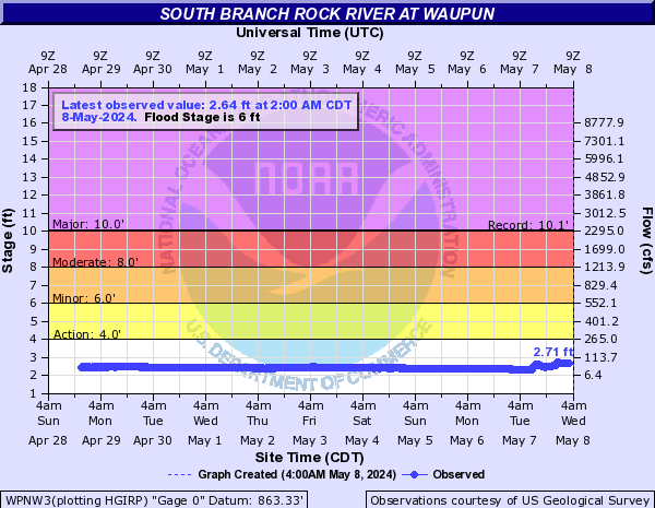
South Branch Rock River (Click on an image to go to hydrograph webpage)
WPNW3:
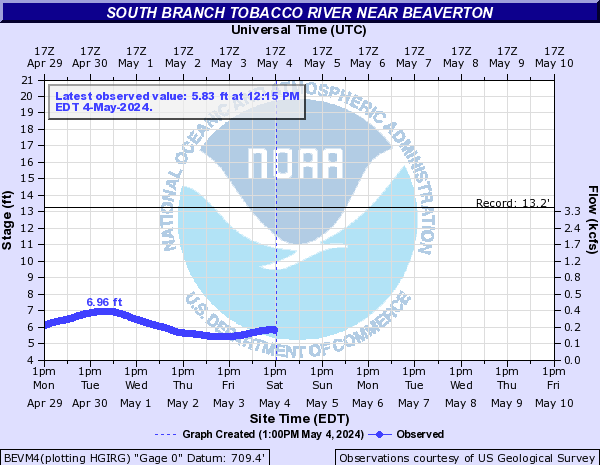
South Branch Tobacco River (Click on an image to go to hydrograph webpage)
BEVM4:
St Clair River (Click on an image to go to hydrograph webpage)
AGCM4:

SCRM4:

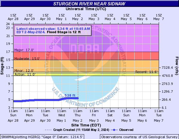
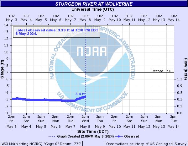
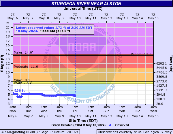
Sturgeon River (Click on an image to go to hydrograph webpage)
SNWM4:
WOLM4:
ALSM4:
CLLM4:

Sturgeon River - Delta Co (Click on an image to go to hydrograph webpage)
NJNM4:

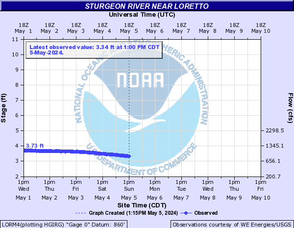
Sturgeon River - Dickinson Co (Click on an image to go to hydrograph webpage)
LORM4:
Swartz Creek (Click on an image to go to hydrograph webpage)
FLSM4:

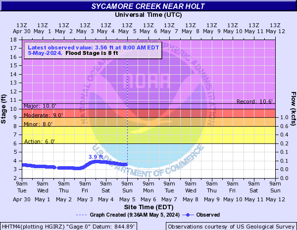
Sycamore Creek (Click on an image to go to hydrograph webpage)
HHTM4:
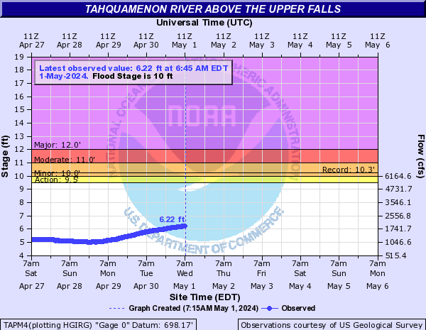
Tahquamenon River (Click on an image to go to hydrograph webpage)
TAPM4:
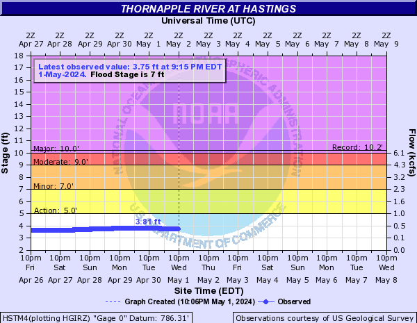
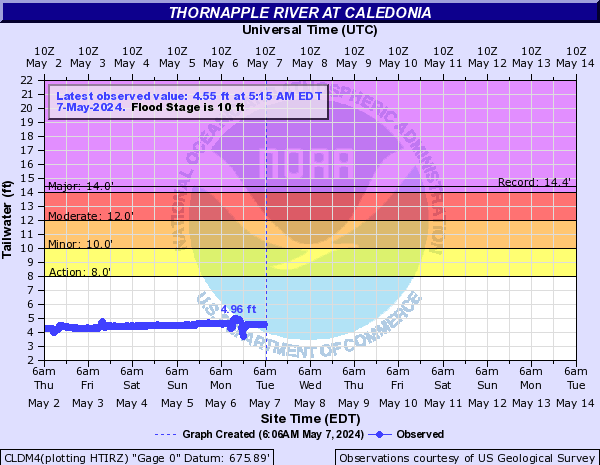
Thornapple River (Click on an image to go to hydrograph webpage)
HSTM4:
CLDM4:
Thread Creek (Click on an image to go to hydrograph webpage)
FTCM4:

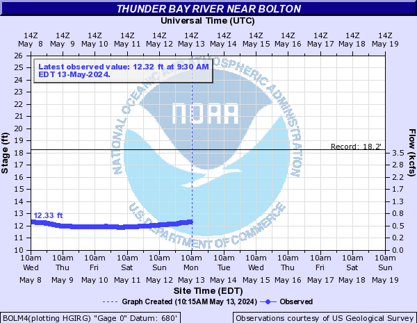
Thunder Bay River (Click on an image to go to hydrograph webpage)
BOLM4:
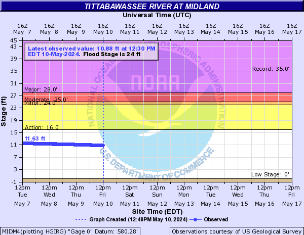
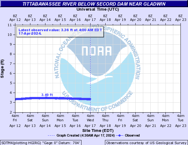
Tittabawassee River (Click on an image to go to hydrograph webpage)
MIDM4:
SDTM4:
SAFM4:

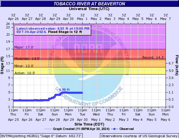
Tobacco River (Click on an image to go to hydrograph webpage)
BVTM4:
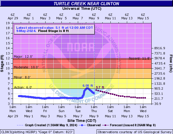
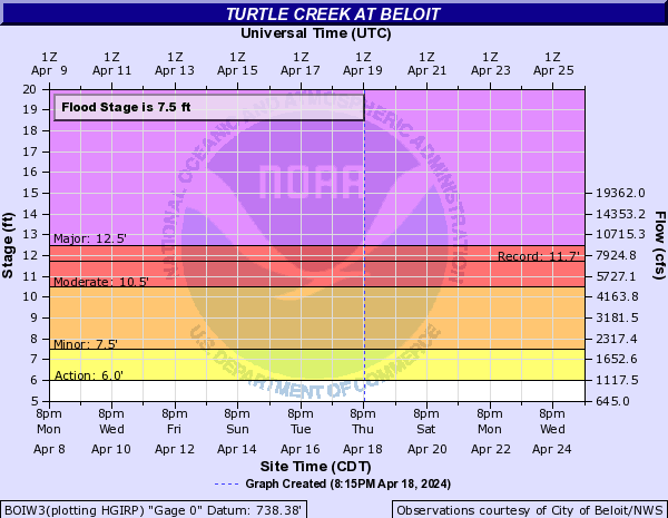
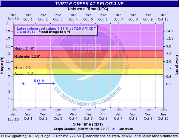
Turtle Creek (Click on an image to go to hydrograph webpage)
CLIW3:
BOIW3:
BLOW3:
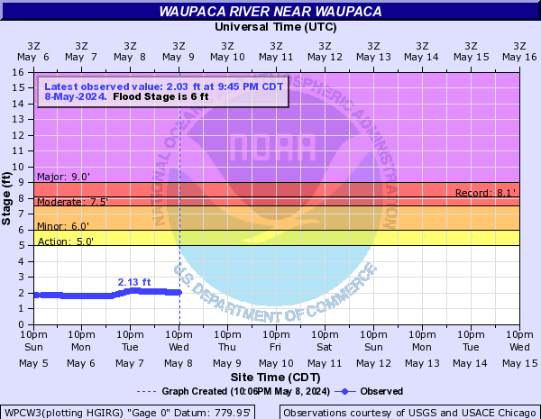
Waupaca River (Click on an image to go to hydrograph webpage)
WPCW3:
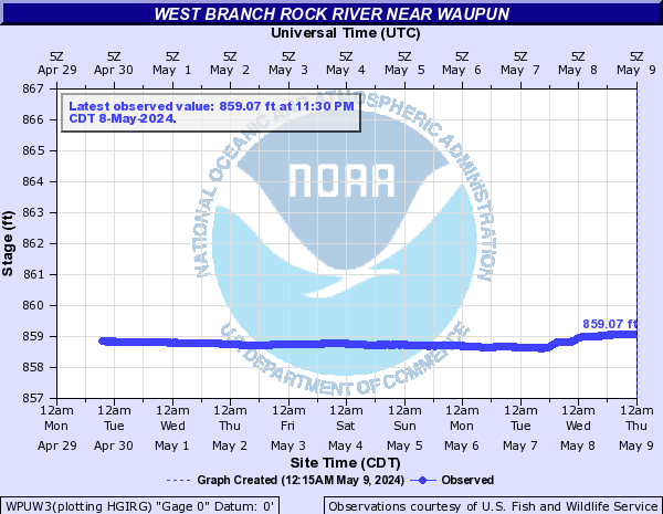
West Branch Rock River (Click on an image to go to hydrograph webpage)
WPUW3:
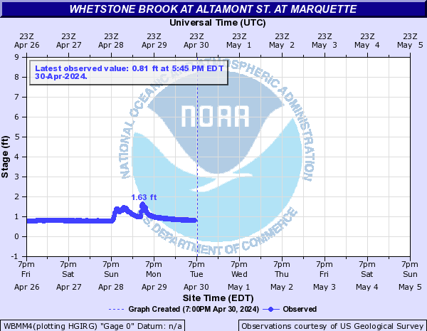
Whetstone Brook (Click on an image to go to hydrograph webpage)
WBMM4:
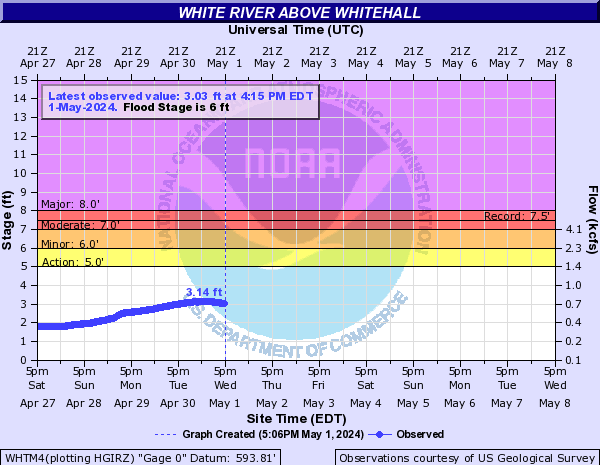
White River (Click on an image to go to hydrograph webpage)
WHTM4:
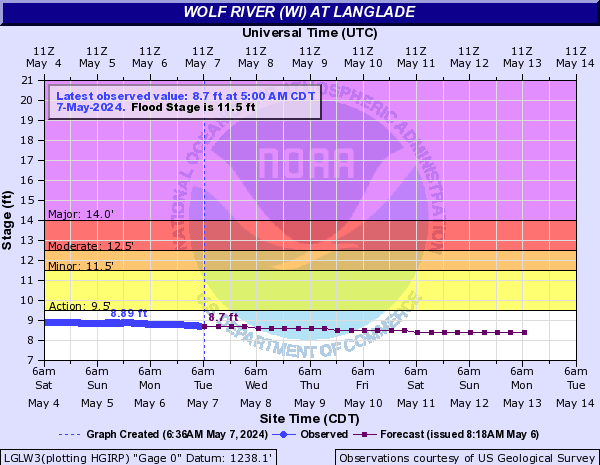
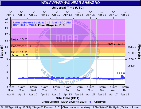
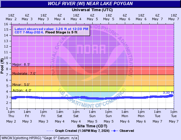
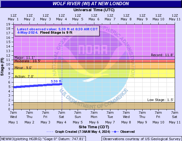
Wolf River (WI) (Click on an image to go to hydrograph webpage)
LGLW3:
SHAW3:
WNCW3:
SHIW3:

NEWW3:
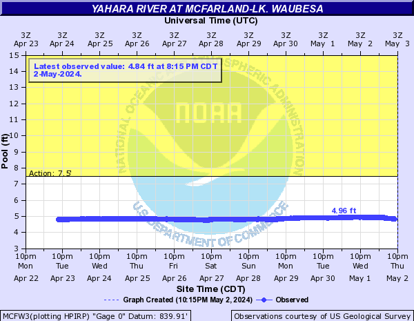
Yahara River (Click on an image to go to hydrograph webpage)
MCFW3:
FULW3:


