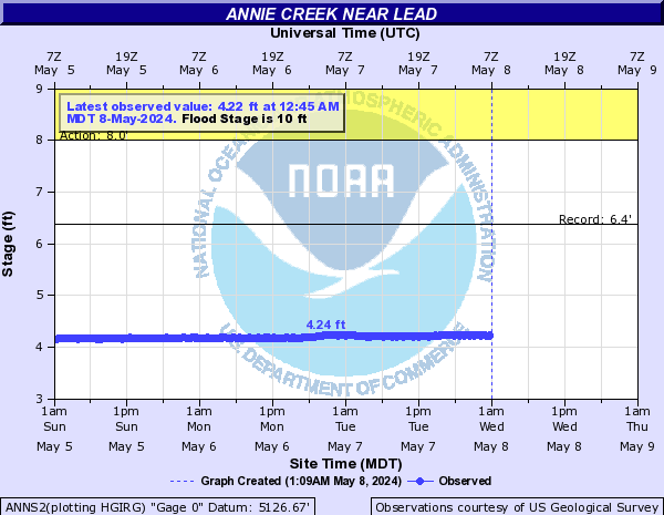
Annie Creek (Click on an image to go to hydrograph webpage)
ANNS2:
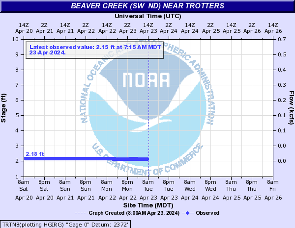
Beaver Creek (SW ND) (Click on an image to go to hydrograph webpage)
TRTN8:
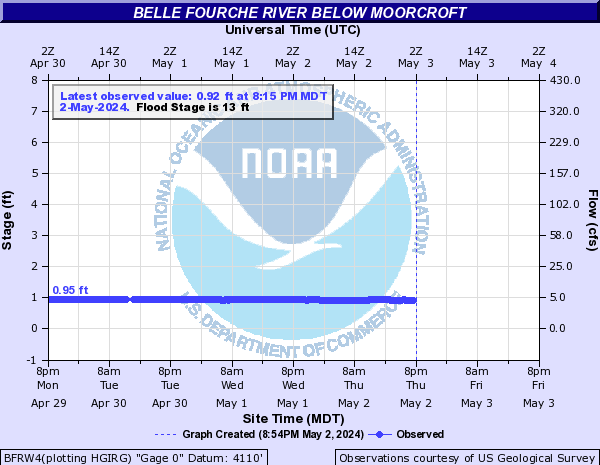
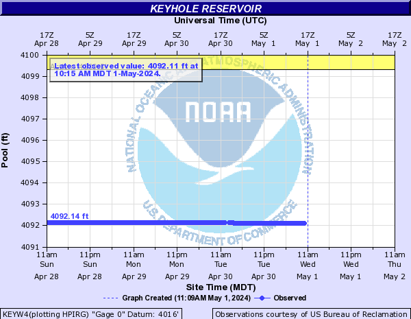
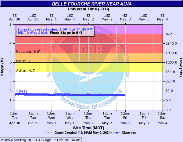
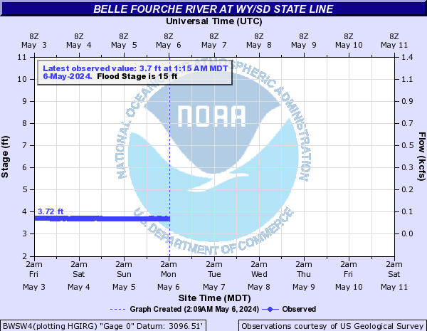
Belle Fourche River (Click on an image to go to hydrograph webpage)
BFRW4:
KEYW4:
BFAW4:
BWSW4:
BLES2:

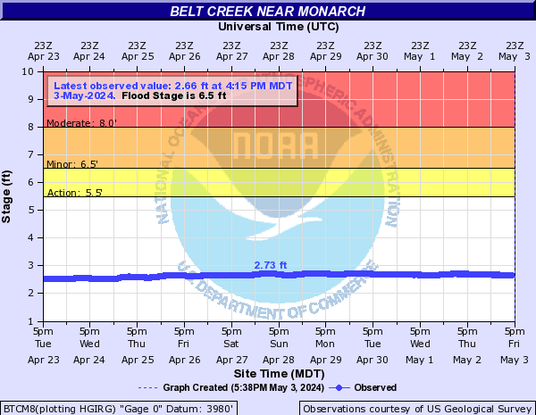
Belt Creek (Click on an image to go to hydrograph webpage)
BTCM8:
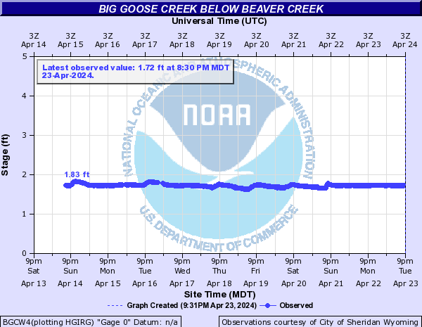
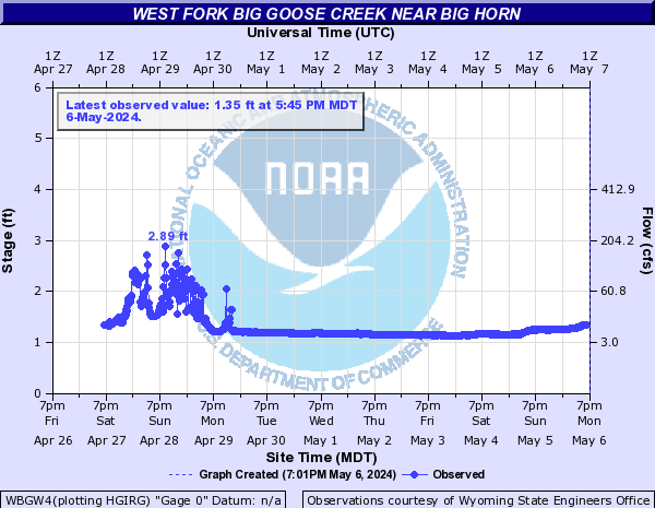
Big Goose Creek (Click on an image to go to hydrograph webpage)
BGDW4:

BGCW4:
Big Spring Creek (MT) (Click on an image to go to hydrograph webpage)
LTPM8:

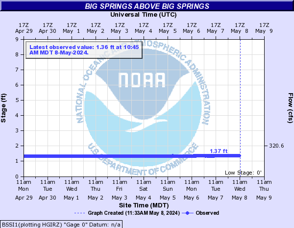
Big Springs (Click on an image to go to hydrograph webpage)
BSSI1:
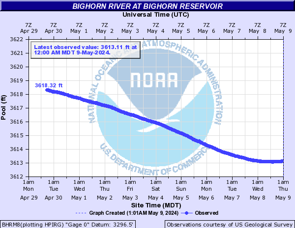
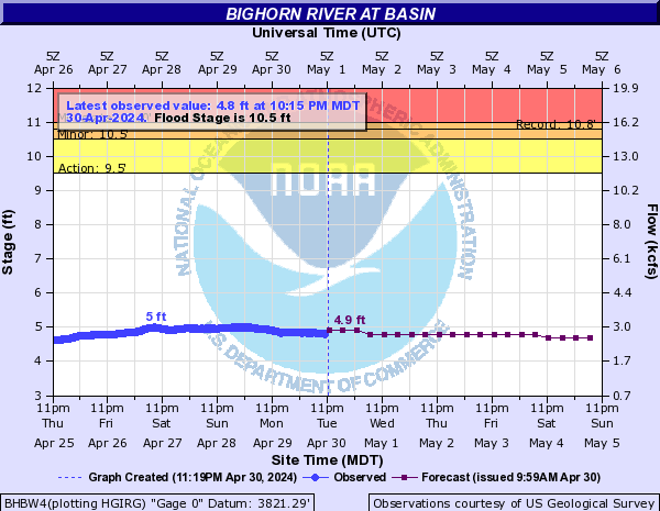
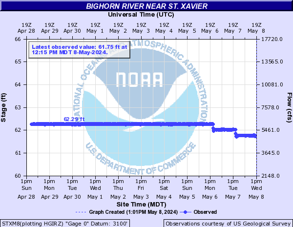
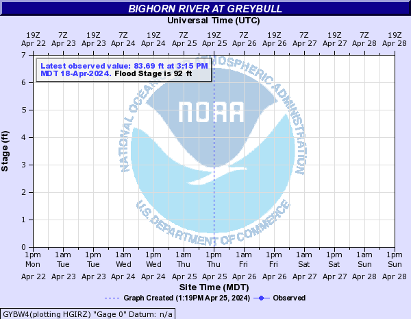
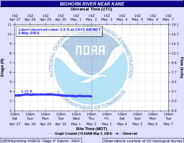
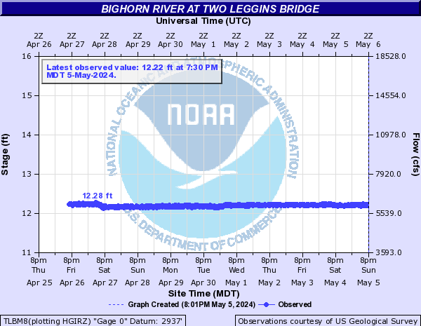
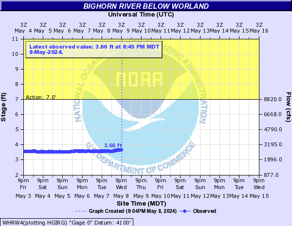
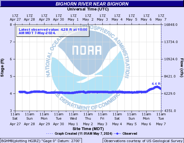
Bighorn River (Click on an image to go to hydrograph webpage)
BHRM8:
BHBW4:
STXM8:
GYBW4:
LVEW4:
SXVM8:

TLBM8:
WHRW4:
BGHM8:
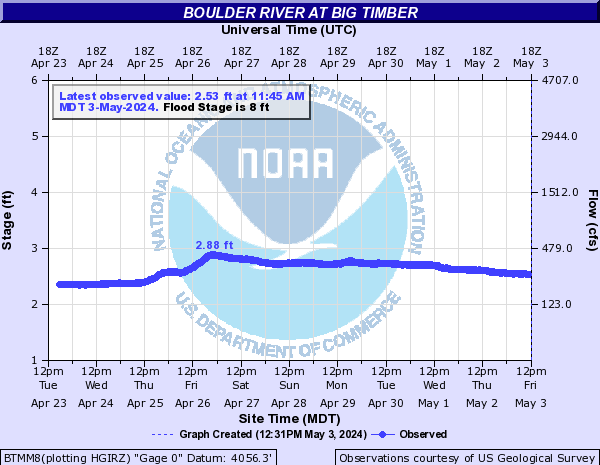
Boulder River (Click on an image to go to hydrograph webpage)
BTMM8:
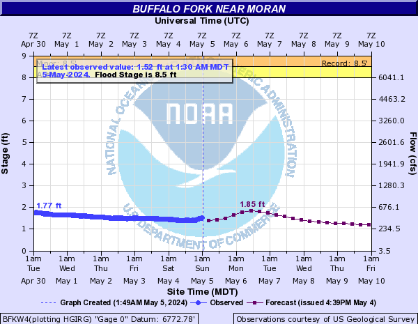
Buffalo Fork (Click on an image to go to hydrograph webpage)
BFKW4:
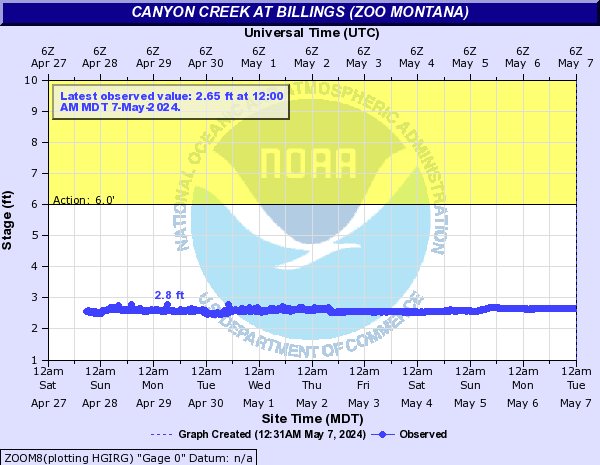
Canyon Creek (Click on an image to go to hydrograph webpage)
ZOOM8:
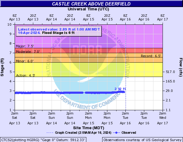
Castle Creek (Click on an image to go to hydrograph webpage)
CTCS2:
DRFS2:

DFBS2:

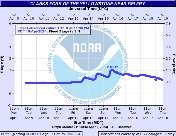
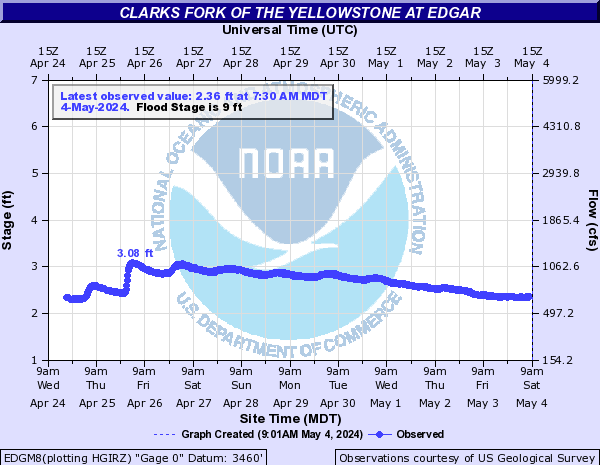
Clarks Fork of the Yellowstone (Click on an image to go to hydrograph webpage)
BFYM8:
EDGM8:
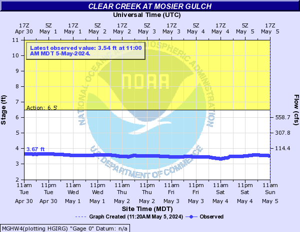
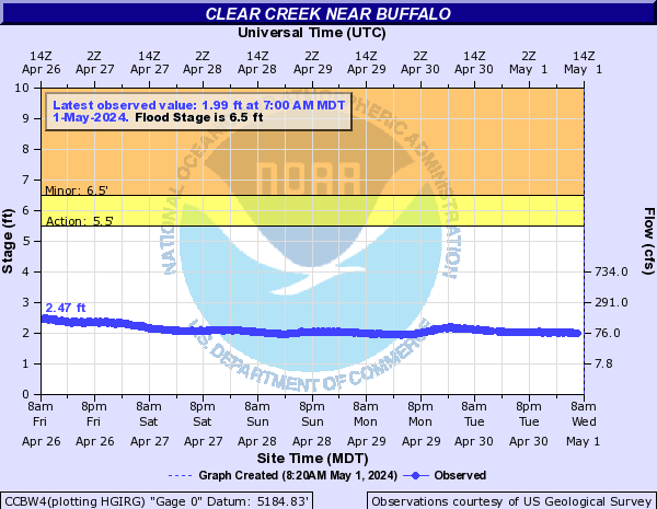
Clear Creek (Click on an image to go to hydrograph webpage)
MGHW4:
CCAW4:

CCBW4:
BCCW4:

Coney Creek (Click on an image to go to hydrograph webpage)
TWLW4:

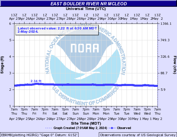
East Boulder River (Click on an image to go to hydrograph webpage)
EBRM8:
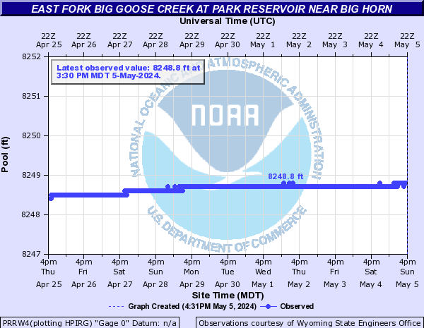
East Fork Big Goose Creek (Click on an image to go to hydrograph webpage)
EFPW4:
PRRW4:
BGBW4:

East Fork Wind River (Click on an image to go to hydrograph webpage)
EFWW4:

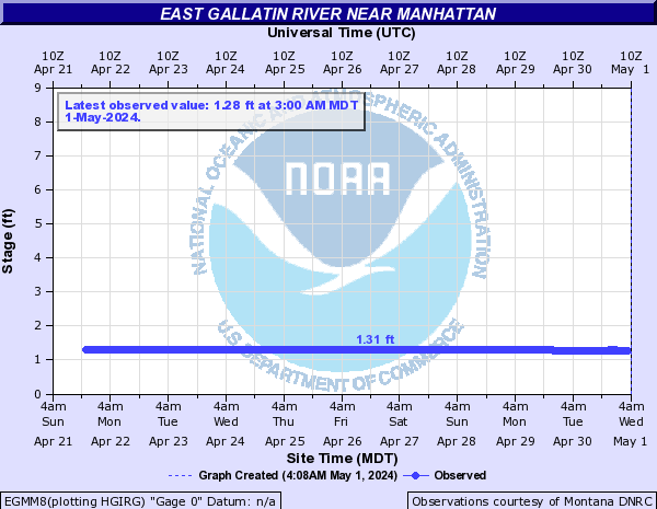
East Gallatin River (Click on an image to go to hydrograph webpage)
EGRM8:

EGBM8:

EGMM8:
East Pass Creek (Click on an image to go to hydrograph webpage)
EPCW4:

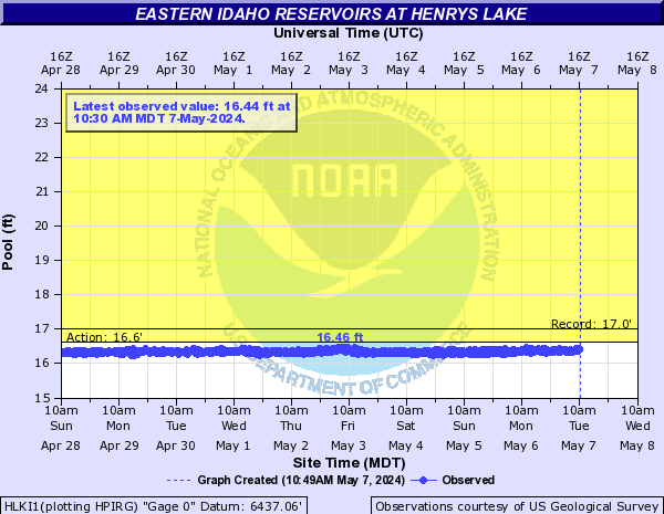
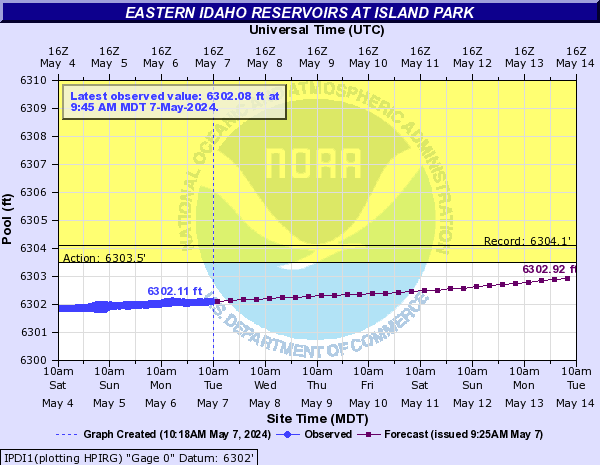
Eastern Idaho Reservoirs (Click on an image to go to hydrograph webpage)
HLKI1:
IPDI1:
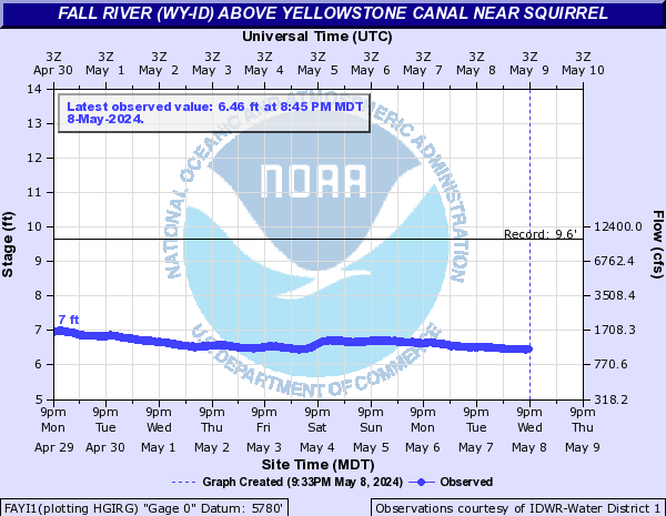
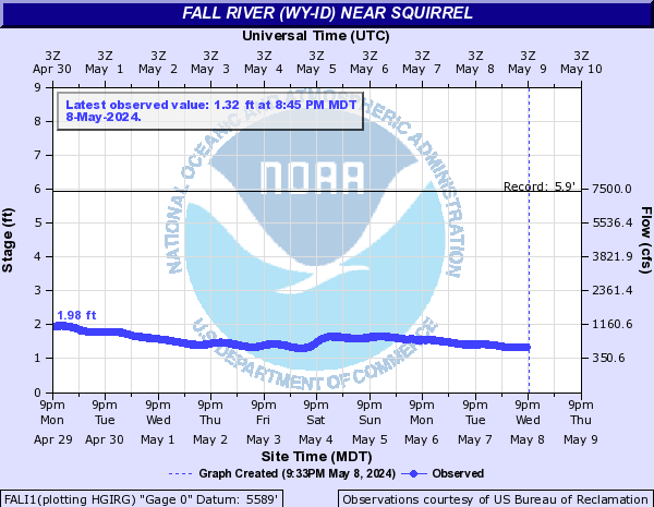
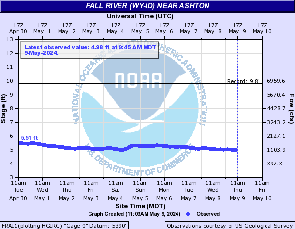
Fall River (WY-ID) (Click on an image to go to hydrograph webpage)
FAYI1:
FALI1:
FRAI1:
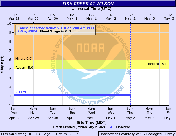
Fish Creek (WY) (Click on an image to go to hydrograph webpage)
FCWW4:
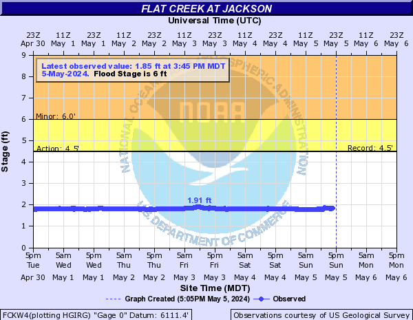
Flat Creek (WY) (Click on an image to go to hydrograph webpage)
FCKW4:
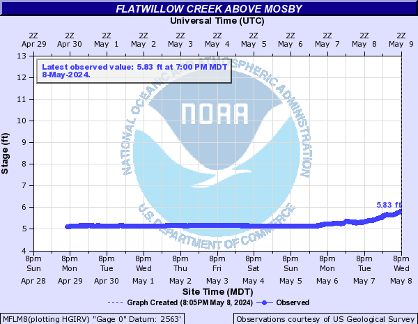
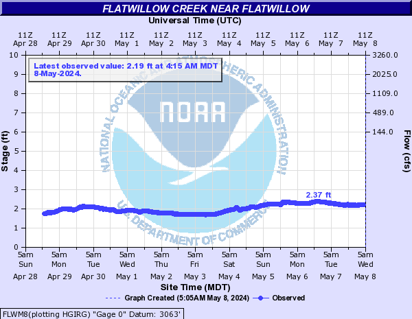
Flatwillow Creek (Click on an image to go to hydrograph webpage)
MFLM8:
FLWM8:
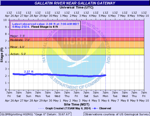
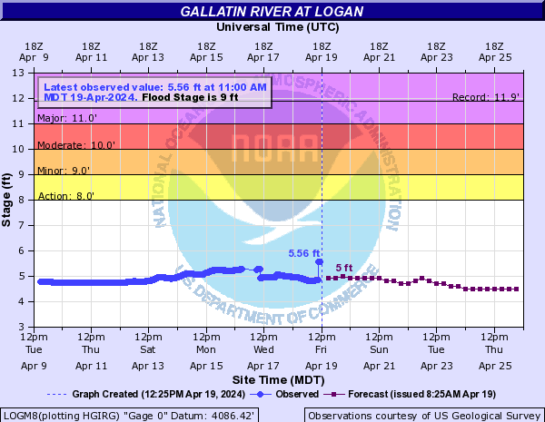
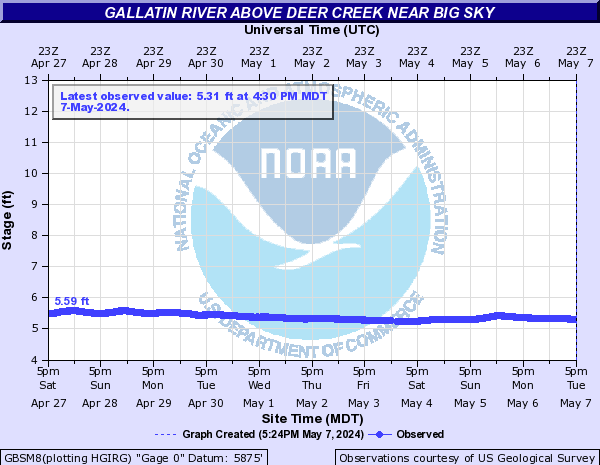
Gallatin River (Click on an image to go to hydrograph webpage)
GLGM8:
LOGM8:
GBSM8:
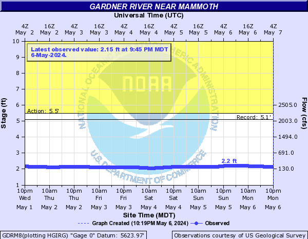
Gardner River (Click on an image to go to hydrograph webpage)
GDRM8:
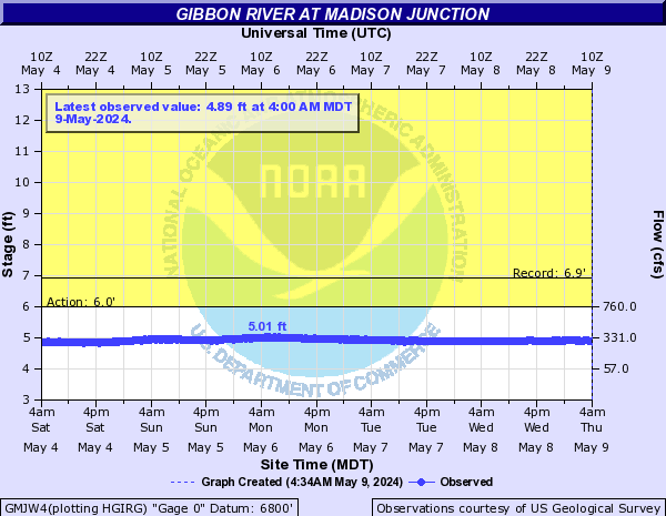
Gibbon River (Click on an image to go to hydrograph webpage)
GMJW4:
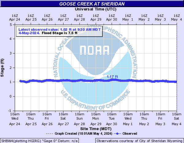
Goose Creek (Click on an image to go to hydrograph webpage)
SHBW4:
GCAW4:

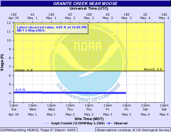
Granite Creek (WY) (Click on an image to go to hydrograph webpage)
GCMW4:
Greybull River (Click on an image to go to hydrograph webpage)
MEEW4:

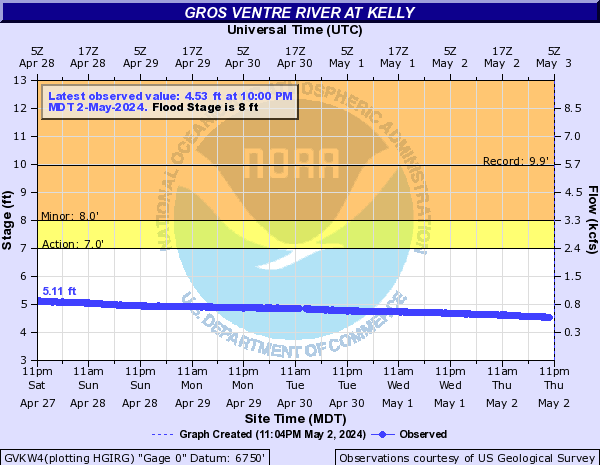
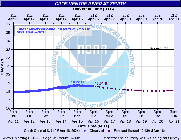
Gros Ventre River (Click on an image to go to hydrograph webpage)
GVKW4:
GVZW4:
GRUW4:
Hanging Woman Creek (Click on an image to go to hydrograph webpage)
HWCM8:

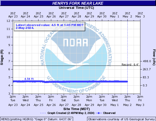
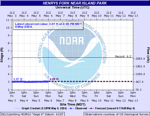
Henrys Fork (Click on an image to go to hydrograph webpage)
HENI1:
ISLI1:
Hyalite Creek (Click on an image to go to hydrograph webpage)
HCCM8:

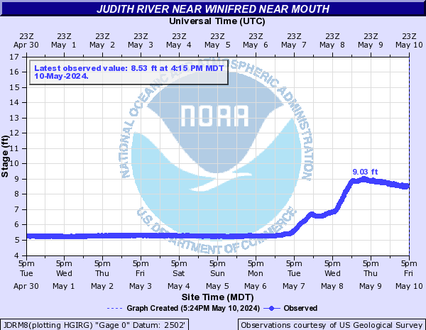
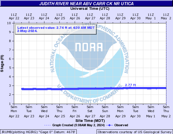
Judith River (Click on an image to go to hydrograph webpage)
JDRM8:
JRUM8:
Lake Creek (MT) (Click on an image to go to hydrograph webpage)
LCPM8:

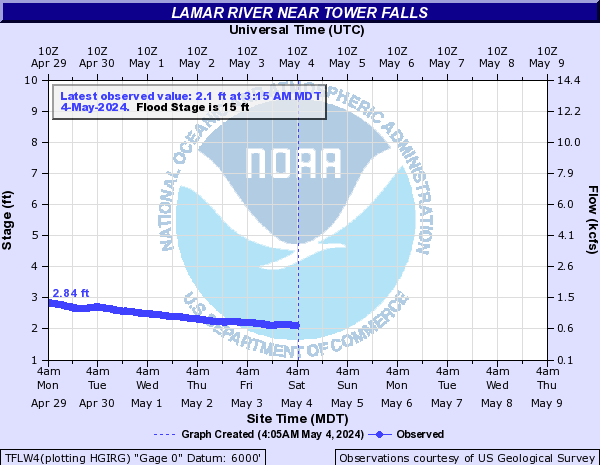
Lamar River (Click on an image to go to hydrograph webpage)
TFLW4:
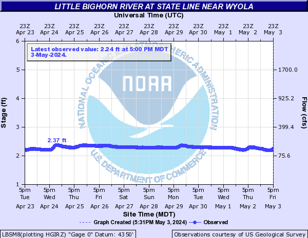
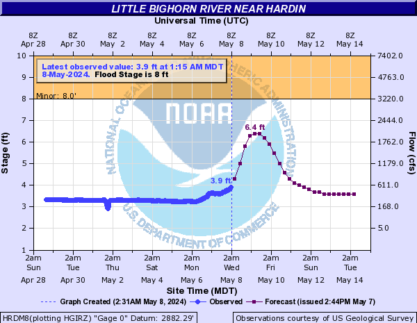
Little Bighorn River (Click on an image to go to hydrograph webpage)
LBSM8:
HRDM8:
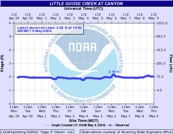
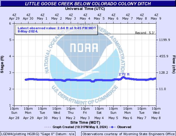
Little Goose Creek (Click on an image to go to hydrograph webpage)
LGCW4:
LGDW4:
LTGW4:

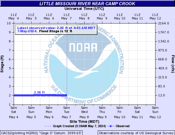
Little Missouri River (Click on an image to go to hydrograph webpage)
MTHN8:

CACS2:
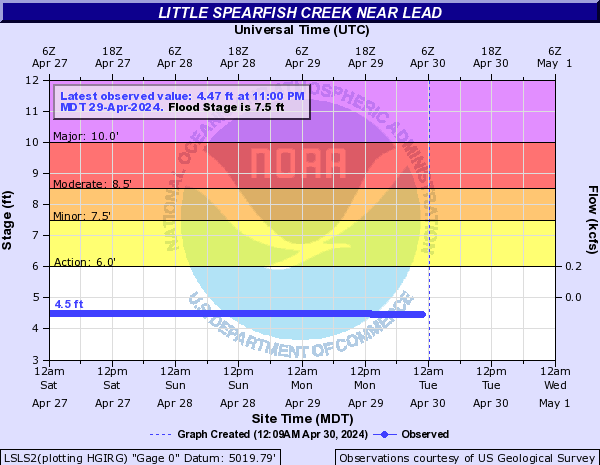
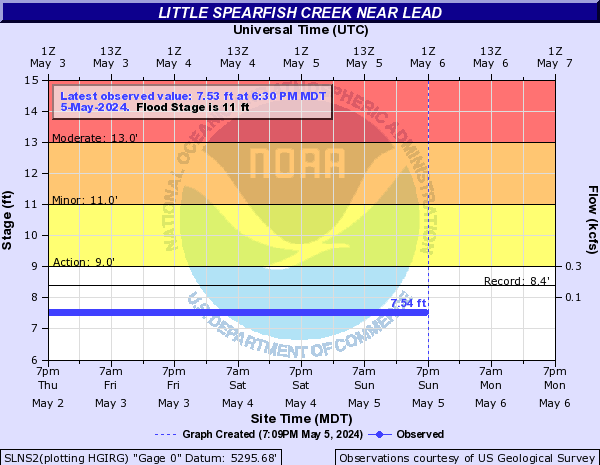
Little Spearfish Creek (Click on an image to go to hydrograph webpage)
LSLS2:
Lodge Grass Creek (Click on an image to go to hydrograph webpage)
LGCM8:

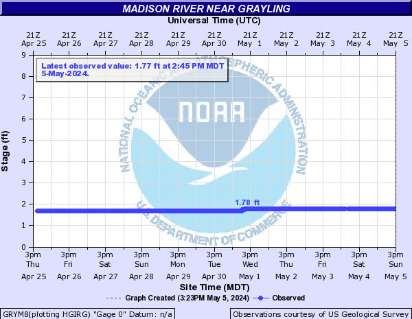
Madison River (Click on an image to go to hydrograph webpage)
MDSM8:

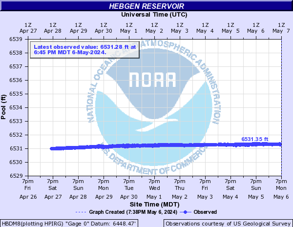
HBDM8:
GRYM8:
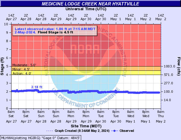
Medicine Lodge Creek (Click on an image to go to hydrograph webpage)
MLHW4:
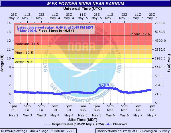
Middle Fork Powder River (Click on an image to go to hydrograph webpage)
MFBW4:
BARW4:

KAYW4:

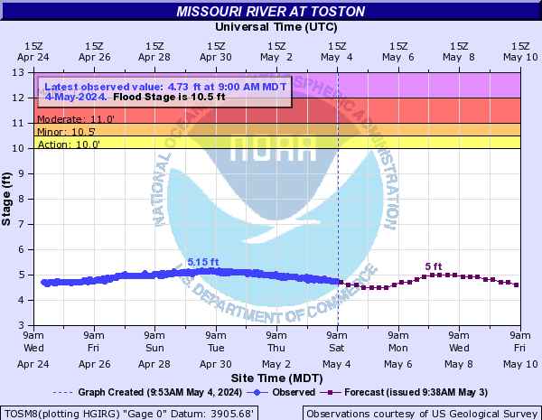
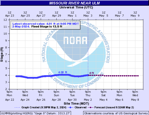
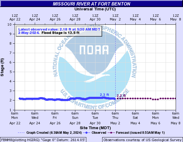
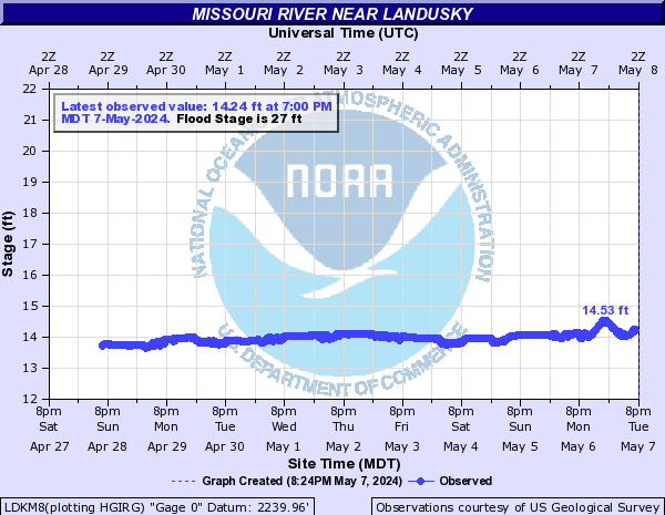
Missouri River (Click on an image to go to hydrograph webpage)
TOSM8:
ULMM8:
GFSM8:
GFLM8:

FBNM8:
LDKM8:
RDZM8:
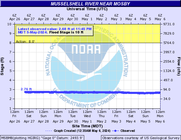
Musselshell River (Click on an image to go to hydrograph webpage)
MRMM8:

MSBM8:
MTCM8:

HLWM8:

SHAM8:

LVNM8:

RUPM8:

MUSM8:

N Fork Musselshell River (Click on an image to go to hydrograph webpage)
DLPM8:
BAIM8:
North Fork Shoshone River (Click on an image to go to hydrograph webpage)
NFSW4:

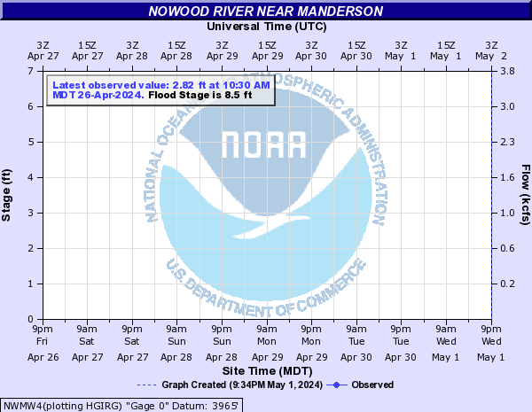
Nowood River (Click on an image to go to hydrograph webpage)
NWMW4:
Otter Creek (Click on an image to go to hydrograph webpage)
OCAM8:

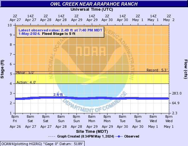
Owl Creek (Click on an image to go to hydrograph webpage)
OCAW4:
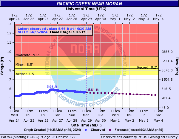
Pacific Creek (Click on an image to go to hydrograph webpage)
PACW4:
Park Diversion Ditch (Click on an image to go to hydrograph webpage)
PDDW4:

Pass Creek (Click on an image to go to hydrograph webpage)
PSCM8:

Piney Creek (Click on an image to go to hydrograph webpage)
PCKW4:

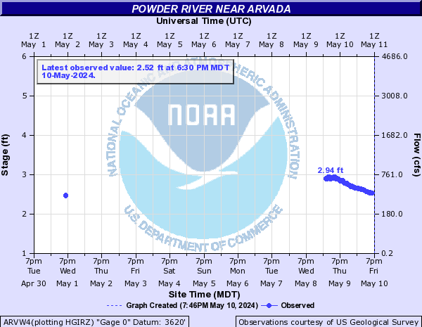
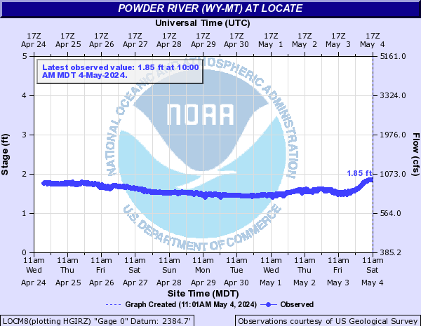
Powder River (WY-MT) (Click on an image to go to hydrograph webpage)
ARVW4:
MHDM8:

LOCM8:
Prairie Dog Creek (Click on an image to go to hydrograph webpage)
PWCW4:

PDAW4:

Pryor Creek (Click on an image to go to hydrograph webpage)
PCPM8:

PYRM8:

Pumpkin Creek (Click on an image to go to hydrograph webpage)
PMKM8:
Rainey Creek (Click on an image to go to hydrograph webpage)
RACI1:
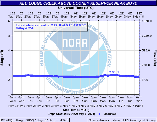
Red Lodge Creek (Click on an image to go to hydrograph webpage)
BYDM8:
Redwater Creek (WY) (Click on an image to go to hydrograph webpage)
RDWS2:
Redwater River (MT) (Click on an image to go to hydrograph webpage)
RRCM8:

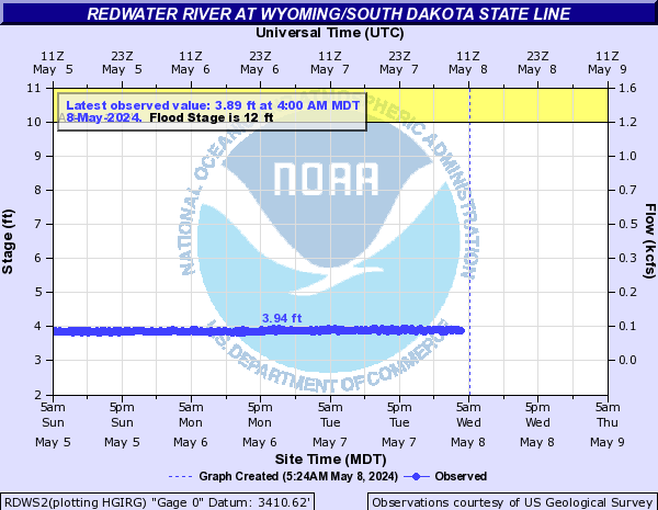
Redwater River (SD) (Click on an image to go to hydrograph webpage)
RWRS2:

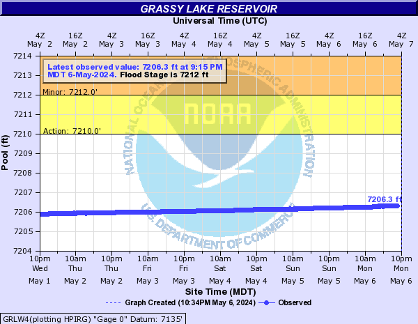
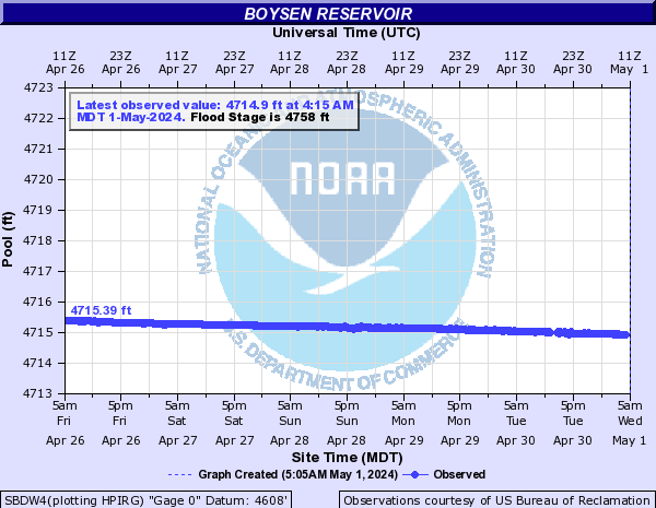
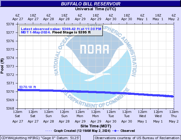
Reservoirs (Click on an image to go to hydrograph webpage)
GRLW4:
SBDW4:
CDYW4:
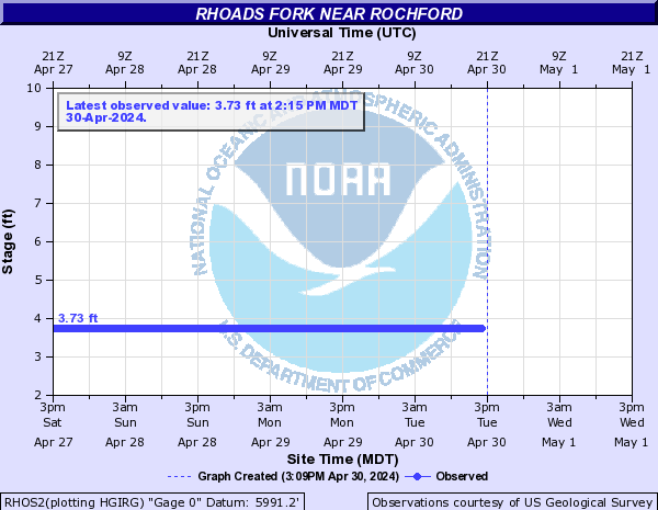
Rhoads Fork (Click on an image to go to hydrograph webpage)
RHOS2:
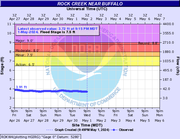
Rock Creek (Click on an image to go to hydrograph webpage)
ROKW4:
Rock Creek (South Central MT) (Click on an image to go to hydrograph webpage)
ROKM8:

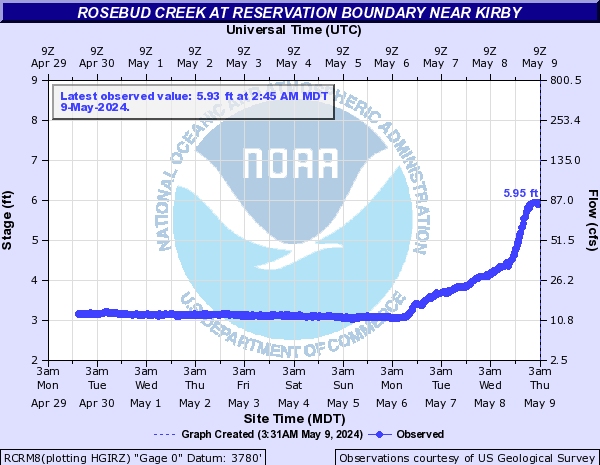
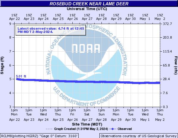
Rosebud Creek (Click on an image to go to hydrograph webpage)
RCRM8:
RBDM8:
RCLM8:
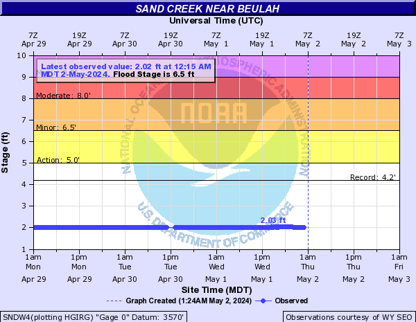
Sand Creek (WY) (Click on an image to go to hydrograph webpage)
SNDW4:
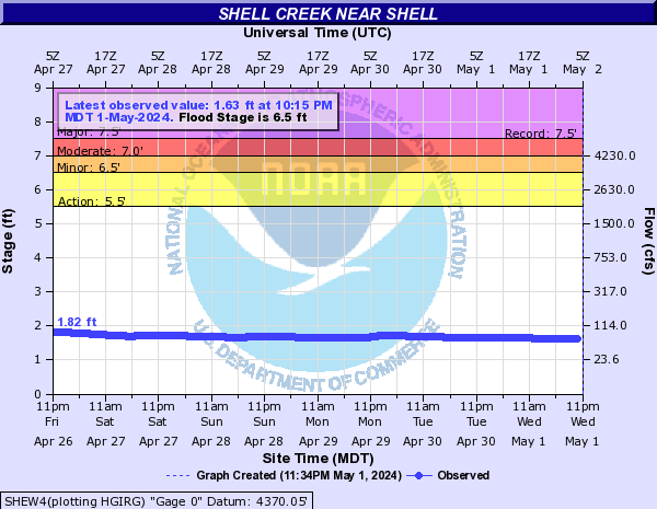
Shell Creek (Click on an image to go to hydrograph webpage)
SHEW4:
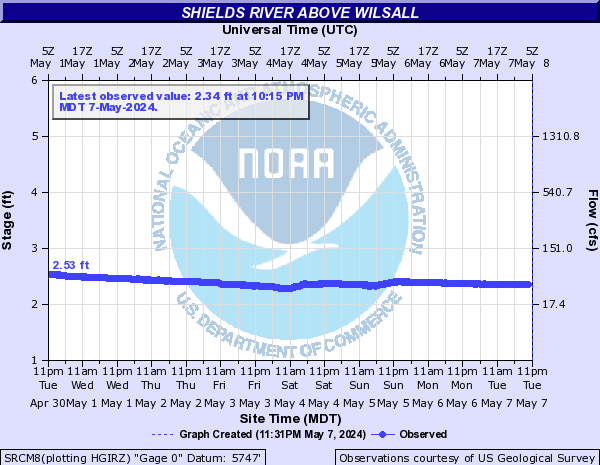
Shields River (Click on an image to go to hydrograph webpage)
SLDM8:
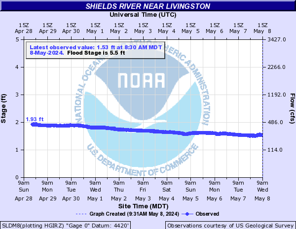
SRCM8:
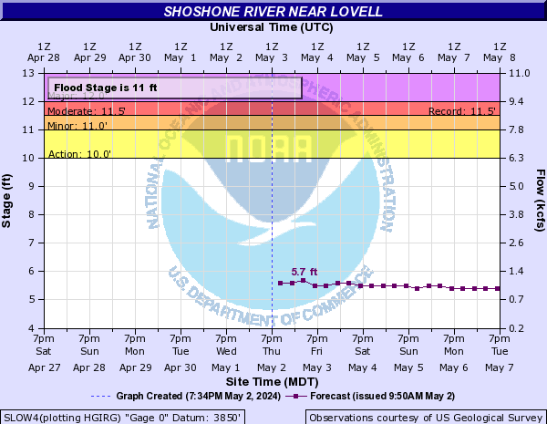
Shoshone River (Click on an image to go to hydrograph webpage)
SLOW4:
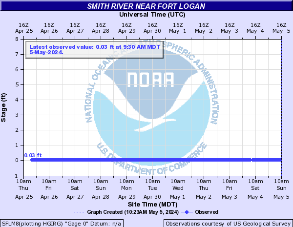
Smith River (MT) (Click on an image to go to hydrograph webpage)
SMHM8:

EDNM8:

ULLM8:

SFLM8:
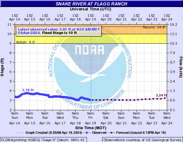
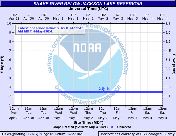
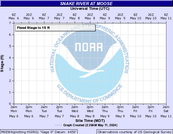
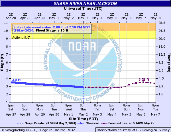
Snake River (Click on an image to go to hydrograph webpage)
PALI1:

FLGW4:
JLKW4:
MSEW4:
JKSW4:
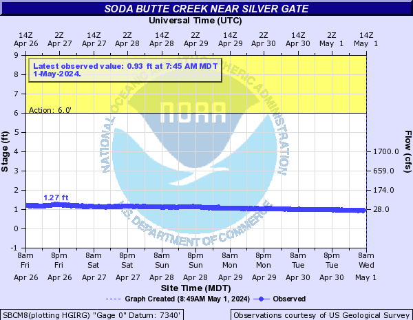
Soda Butte Creek (Click on an image to go to hydrograph webpage)
SBCM8:
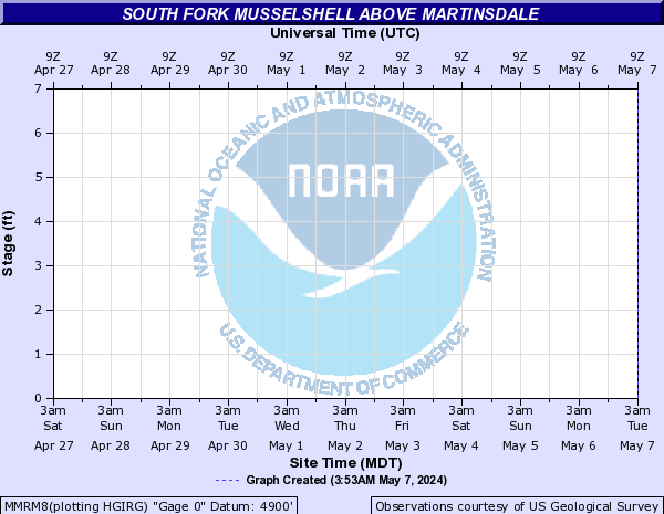
South Fork Musselshell (Click on an image to go to hydrograph webpage)
MMRM8:
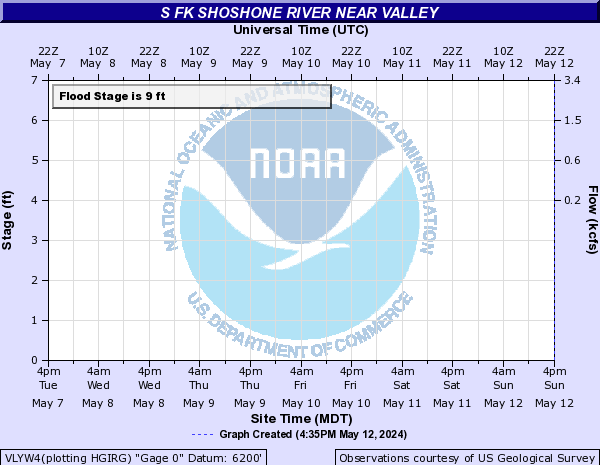
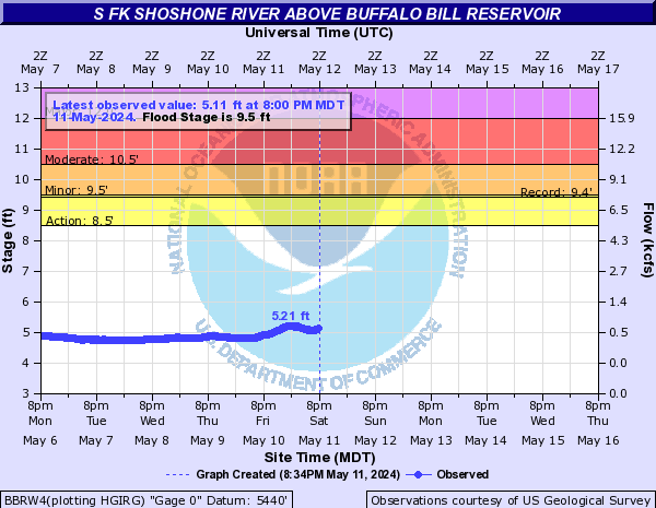
South Fork Shoshone River (Click on an image to go to hydrograph webpage)
VLYW4:
BBRW4:
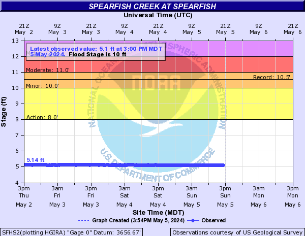
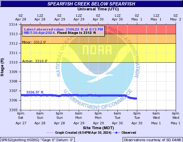
Spearfish Creek (Click on an image to go to hydrograph webpage)
SLNS2:
SFHS2:
SPRS2:
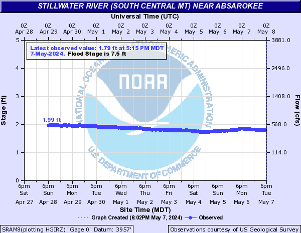
Stillwater River (South Central MT) (Click on an image to go to hydrograph webpage)
SRAM8:
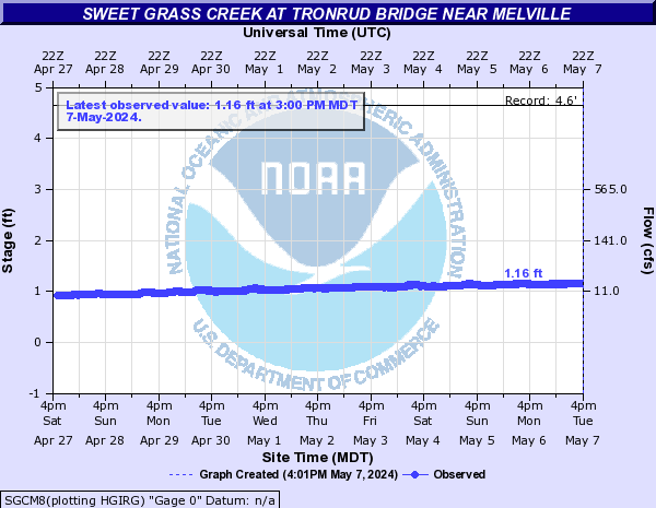
Sweet Grass Creek (Click on an image to go to hydrograph webpage)
SGCM8:
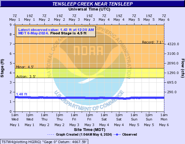
Tensleep Creek (Click on an image to go to hydrograph webpage)
TSTW4:
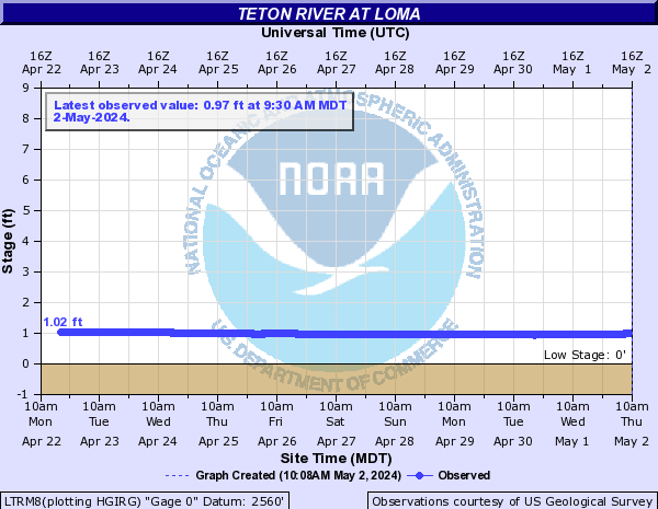
Teton River (Click on an image to go to hydrograph webpage)
LTRM8:
Teton River (ID) (Click on an image to go to hydrograph webpage)
DGGI1:

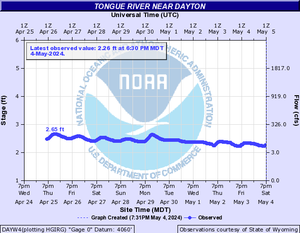
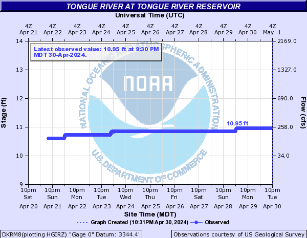
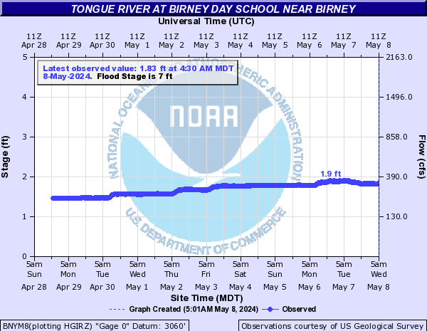
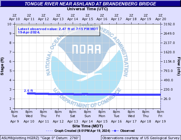
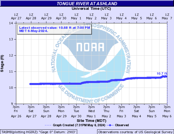
Tongue River (Click on an image to go to hydrograph webpage)
DAYW4:
TRMW4:

DSLM8:
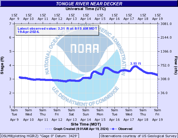
DKRM8:
BNYM8:
ASLM8:
TYDM8:

MICM8:

TASM8:
West Fork Big Goose Creek (Click on an image to go to hydrograph webpage)
WBGW4:
WBDW4:

DMRW4:

SWRW4:

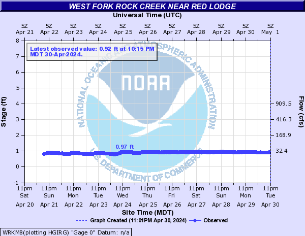
West Fork Rock Creek (Click on an image to go to hydrograph webpage)
WRKM8:
West Pass Creek (Click on an image to go to hydrograph webpage)
WPPW4:

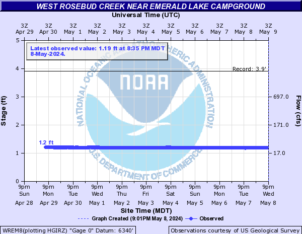
West Rosebud Creek (Click on an image to go to hydrograph webpage)
WREM8:
WRDM8:

Wild Horse Creek (Click on an image to go to hydrograph webpage)
WHCW4:
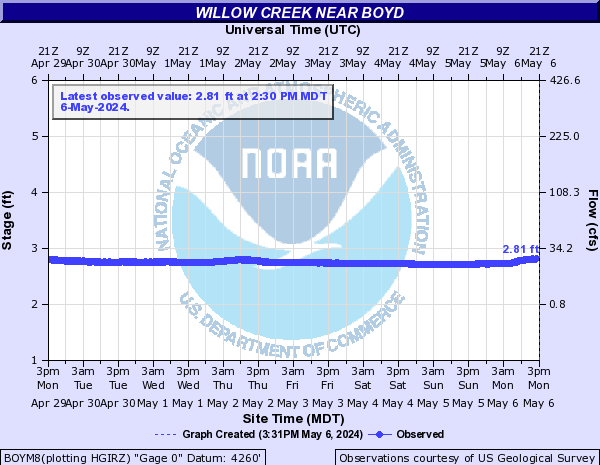
Willow Creek (Click on an image to go to hydrograph webpage)
BOYM8:
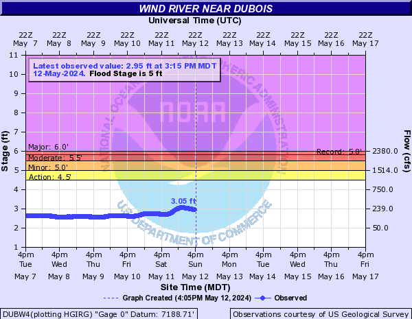
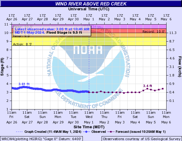
Wind River (Click on an image to go to hydrograph webpage)
DUBW4:
WRCW4:
Wolf Creek (Click on an image to go to hydrograph webpage)
WLFW4:

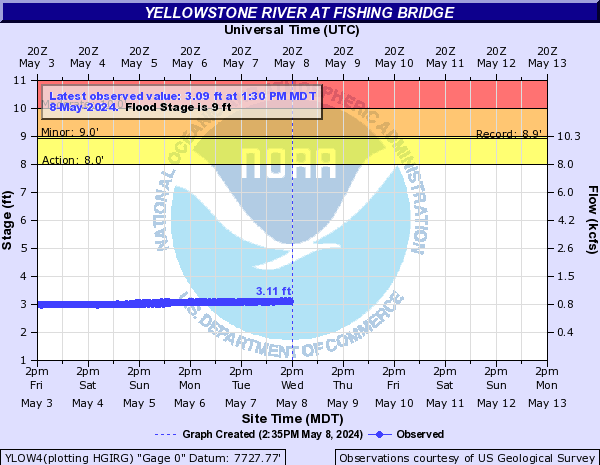
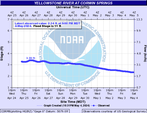
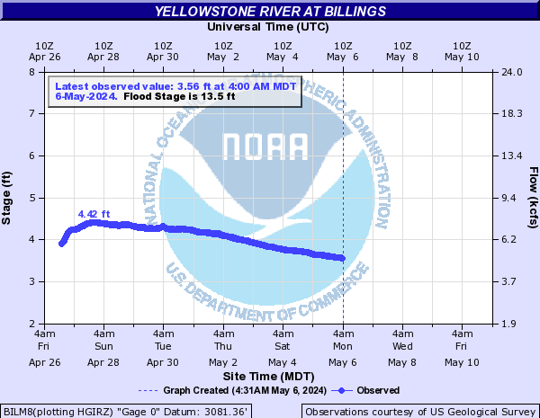
Yellowstone River (Click on an image to go to hydrograph webpage)
YLOW4:
GLNM8:

CORM8:
LIVM8:

SIDM8:

BILM8:
HTDM8:

FRYM8:

MILM8:


