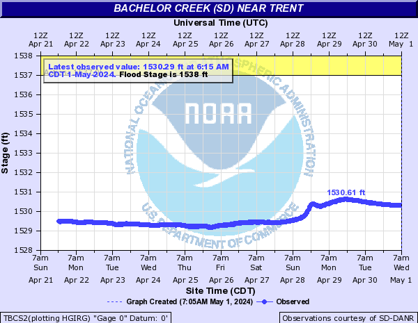
Bachelor Creek (SD) (Click on an image to go to hydrograph webpage)
TBCS2:
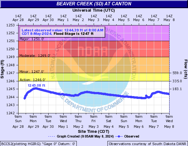
Beaver Creek (SD) (Click on an image to go to hydrograph webpage)
BCCS2:
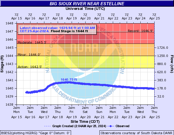
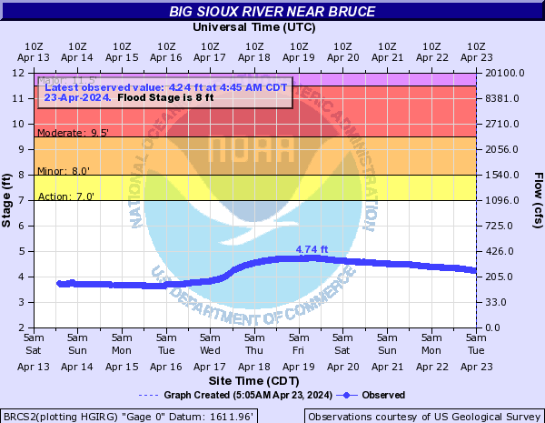
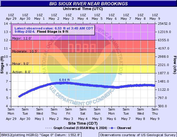
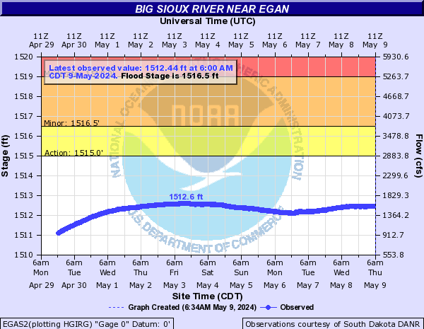
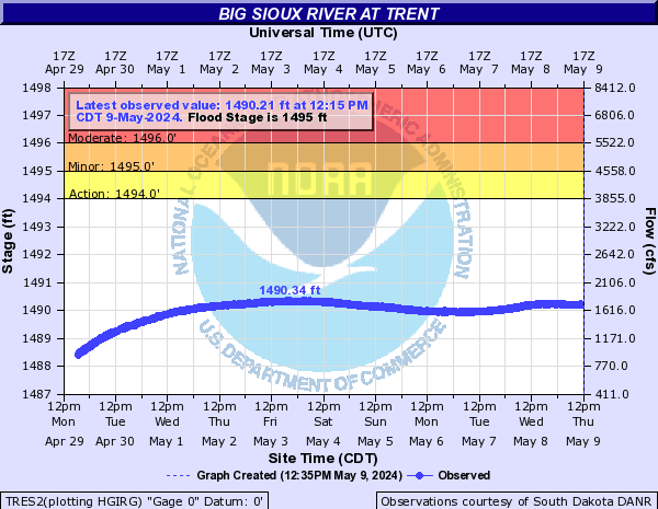
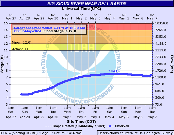
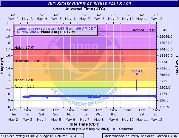
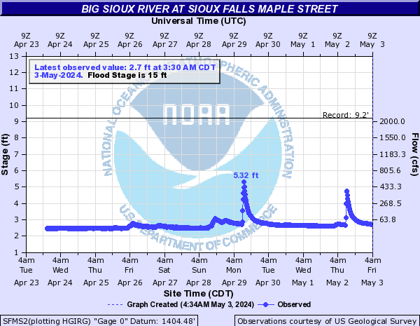
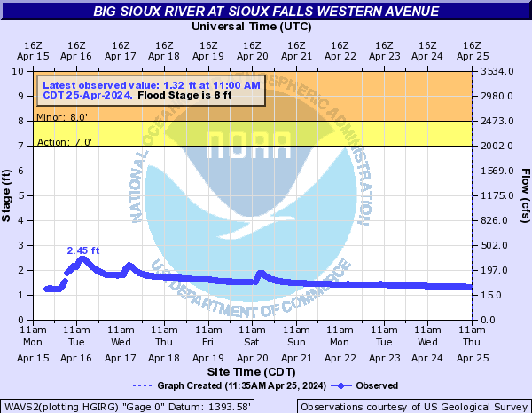
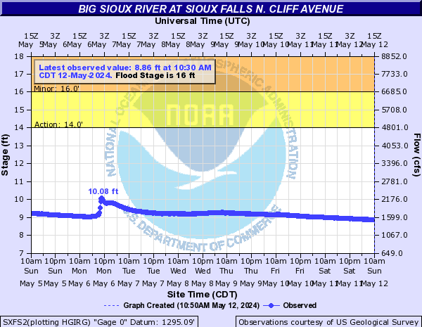
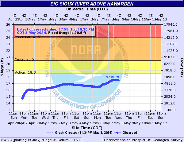
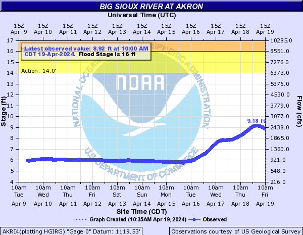
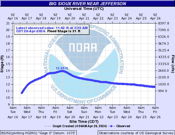
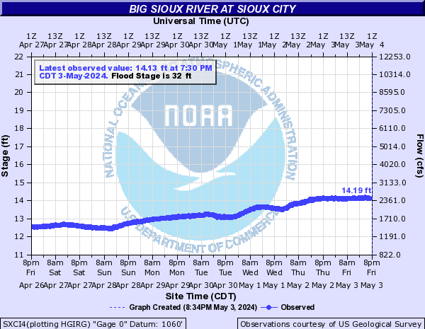
Big Sioux River (Click on an image to go to hydrograph webpage)
BSES2:
BRCS2:
BRKS2:
BSFS2:

EGAS2:
TRES2:
DRBS2:

DERS2:
SFLS2:
SFMS2:
WAVS2:
SXFS2:
BBSS2:

CBSS2:

FVWS2:

FVWS2:
HWDI4:
AKRI4:
BSRS2:

BSJS2:
SXCI4:
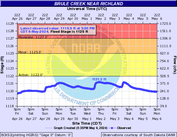
Brule Creek (Click on an image to go to hydrograph webpage)
BCKS2:
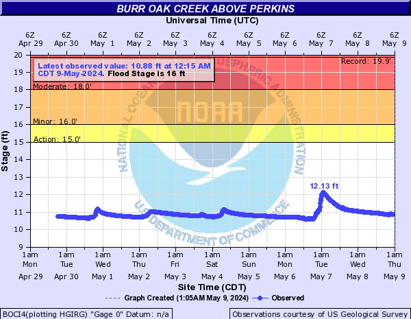
Burr Oak Creek (Click on an image to go to hydrograph webpage)
BOCI4:
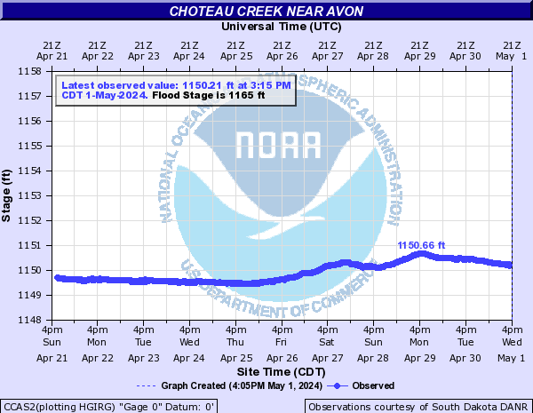
Choteau Creek (Click on an image to go to hydrograph webpage)
CCAS2:
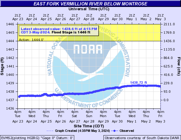
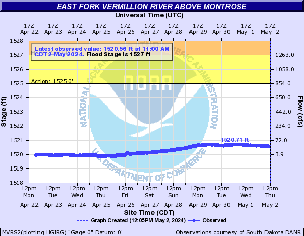
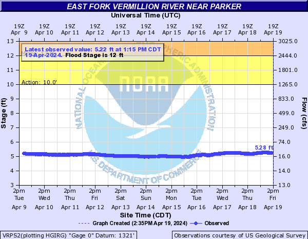
East Fork Vermillion River (Click on an image to go to hydrograph webpage)
EVMS2:
MVRS2:
VRPS2:
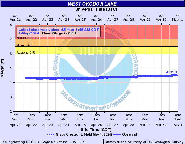
East Okoboji Lake (Click on an image to go to hydrograph webpage)
EOLI4:

EWOI4:

Elliott Creek (Click on an image to go to hydrograph webpage)
ECLI4:

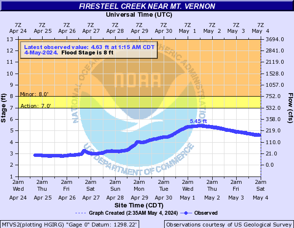
Firesteel Creek (Click on an image to go to hydrograph webpage)
MTVS2:
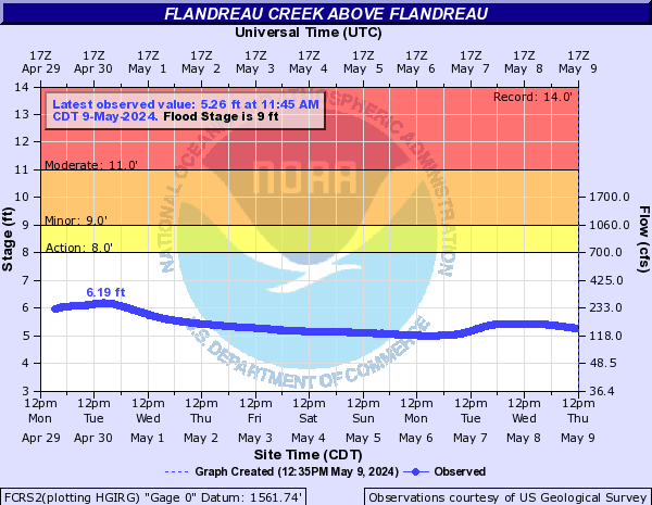
Flandreau Creek (Click on an image to go to hydrograph webpage)
FCRS2:
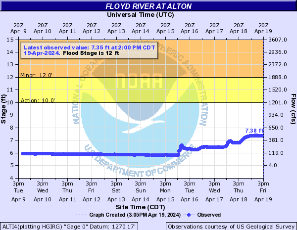
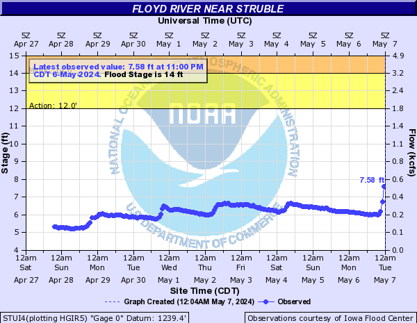
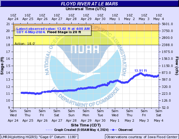
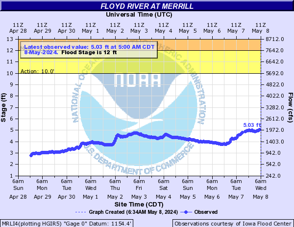
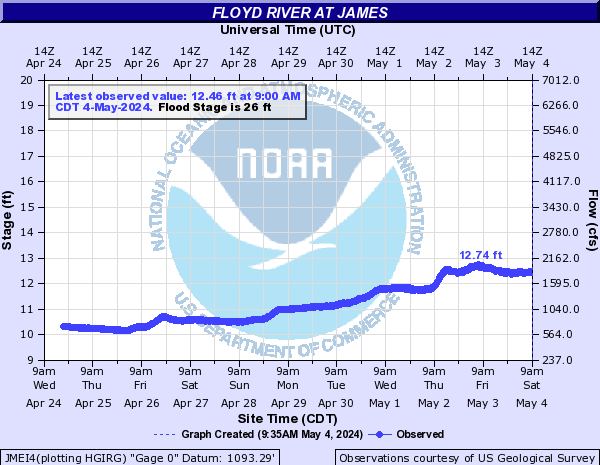
Floyd River (Click on an image to go to hydrograph webpage)
SHLI4:

SFRI4:

ALTI4:
STUI4:
LMRI4:
MRLI4:
JMEI4:
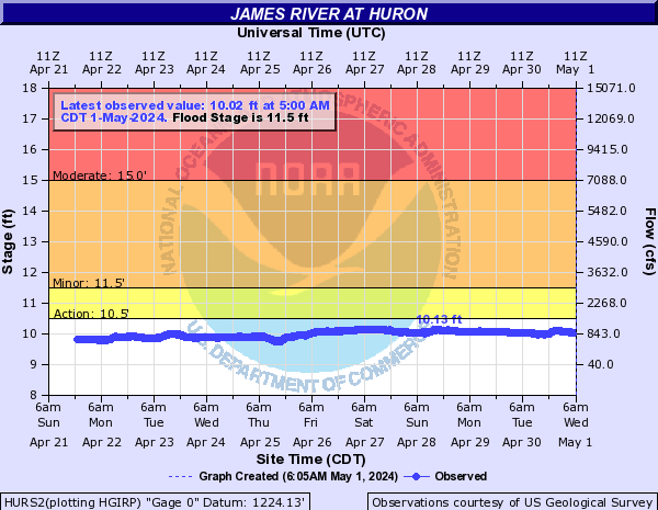
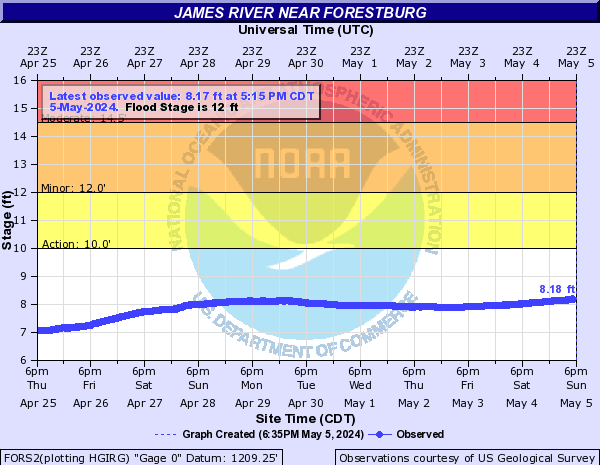
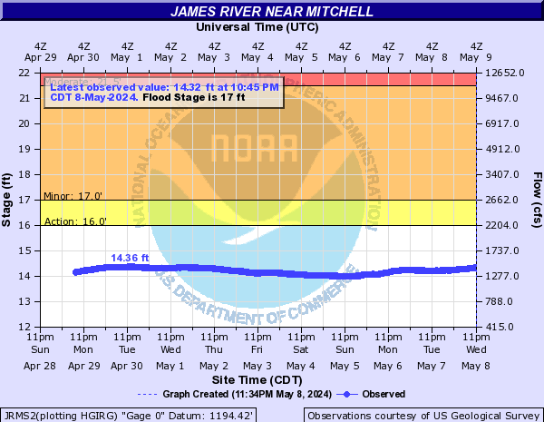
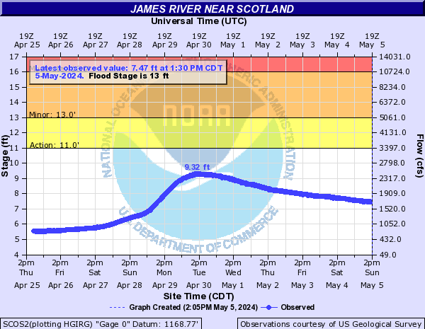
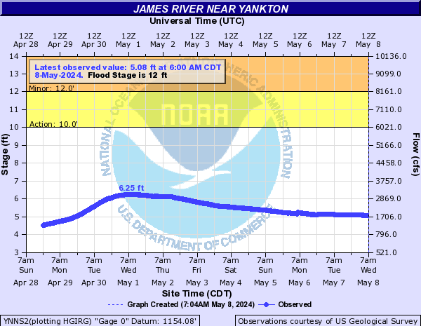
James River (Click on an image to go to hydrograph webpage)
HURS2:
FORS2:
JRMS2:
SCOS2:
YNNS2:
Little Floyd River (Click on an image to go to hydrograph webpage)
LFSI4:

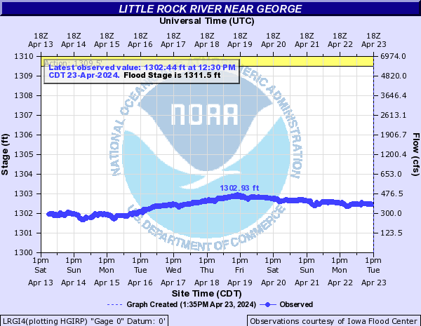
Little Rock River (Click on an image to go to hydrograph webpage)
LRGI4:
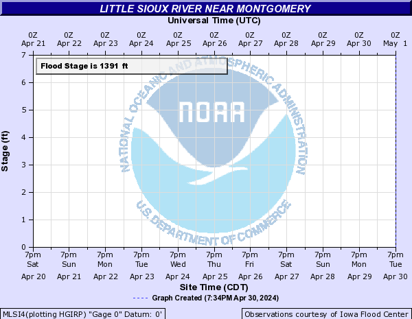
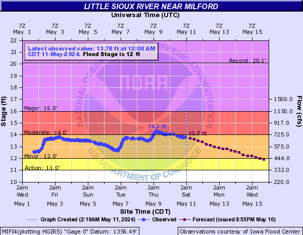
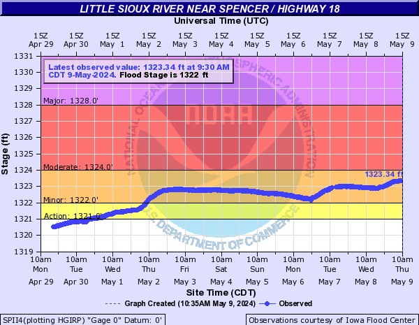
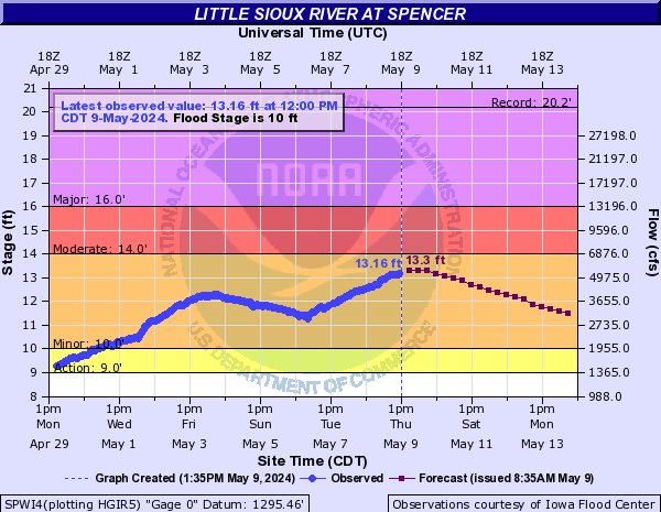
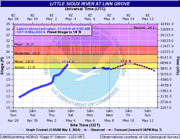
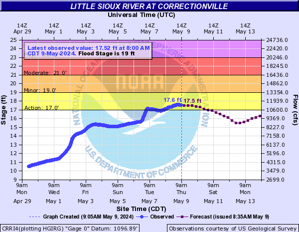
Little Sioux River (Click on an image to go to hydrograph webpage)
MLSI4:
MIFI4:
LSSI4:

SPII4:
SPWI4:
LNNI4:
CHKI4:

CRRI4:
Little Vermillion River (Click on an image to go to hydrograph webpage)
LVSS2:

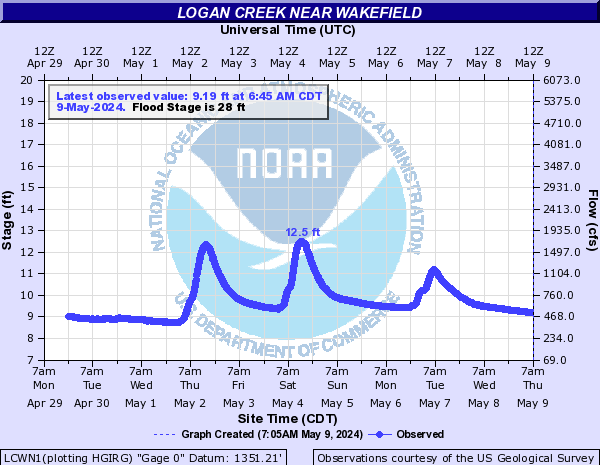
Logan Creek (Click on an image to go to hydrograph webpage)
LCWN1:
Loon Creek (Click on an image to go to hydrograph webpage)
LCKM5:

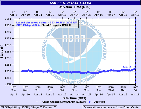
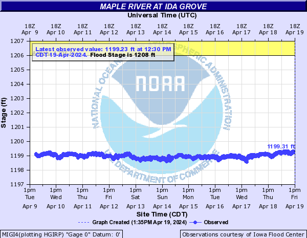
Maple River (Click on an image to go to hydrograph webpage)
MRGI4:
MIGI4:
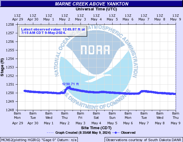
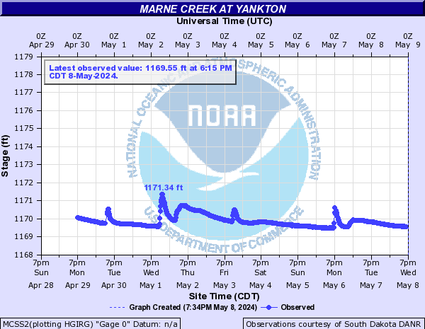
Marne Creek (Click on an image to go to hydrograph webpage)
MCNS2:
MCSS2:
Medary Creek (Click on an image to go to hydrograph webpage)
MDYS2:

Milford Creek (Click on an image to go to hydrograph webpage)
OBJI4:
LGLI4:
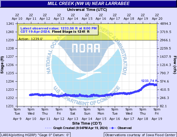
Mill Creek (NW IA) (Click on an image to go to hydrograph webpage)
LARI4:
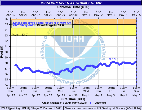
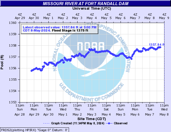
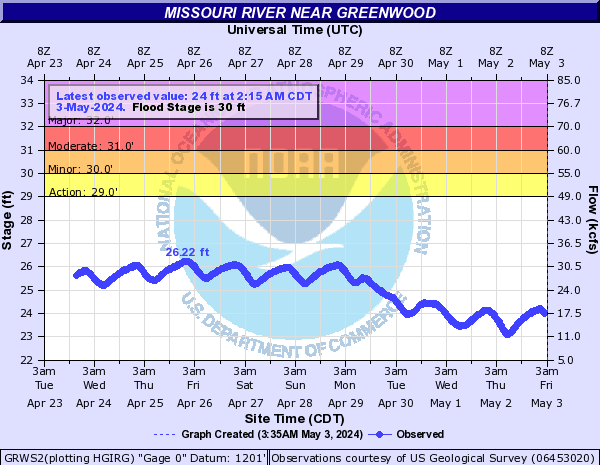
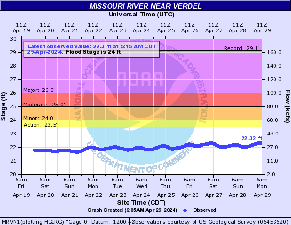
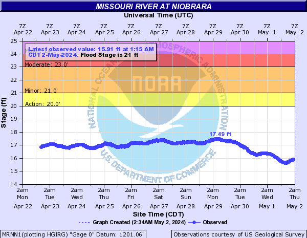
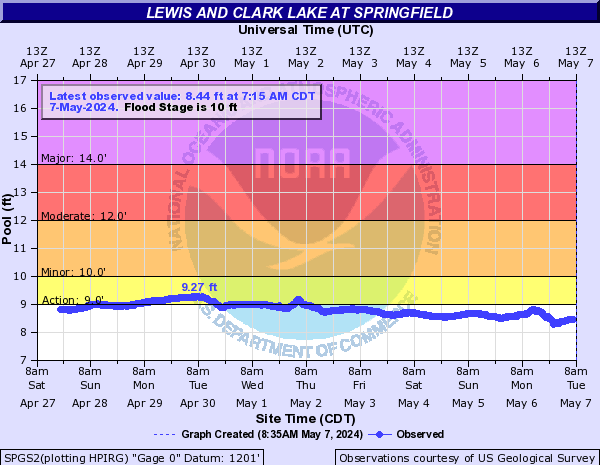
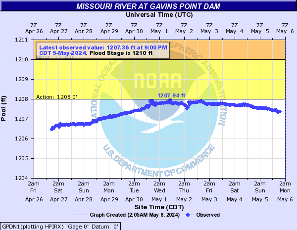
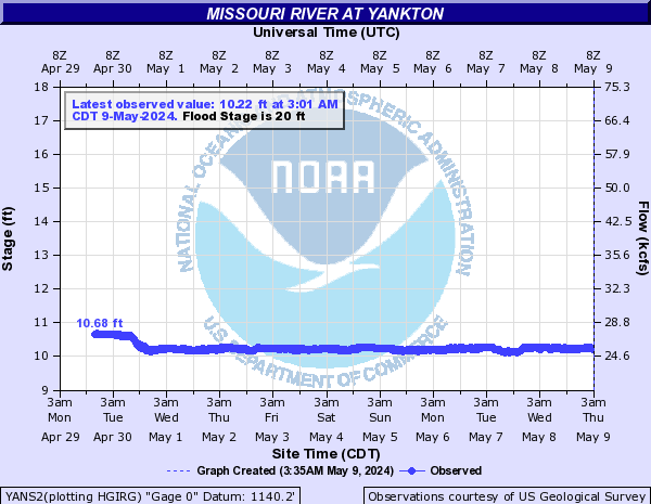
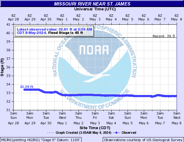
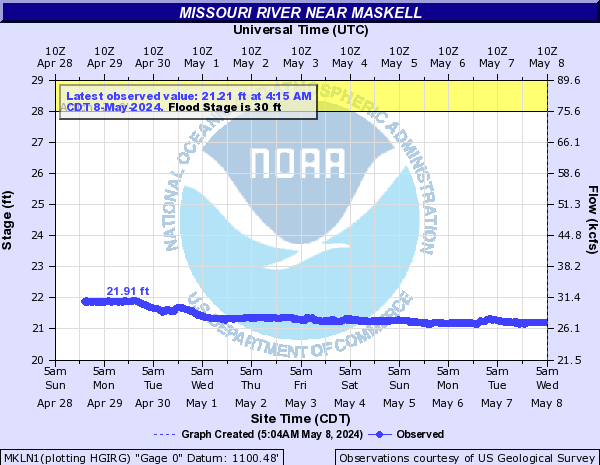
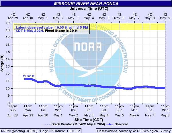
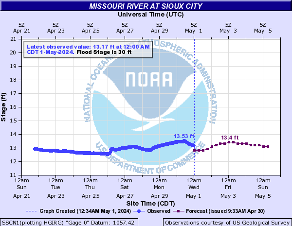
Missouri River (Click on an image to go to hydrograph webpage)
CBLS2:
FRDS2:
GRWS2:
MRVN1:
MRNN1:
SPGS2:
GPDN1:
YANS2:
MSJN1:
MKLN1:
MRPN1:
SSCN1:
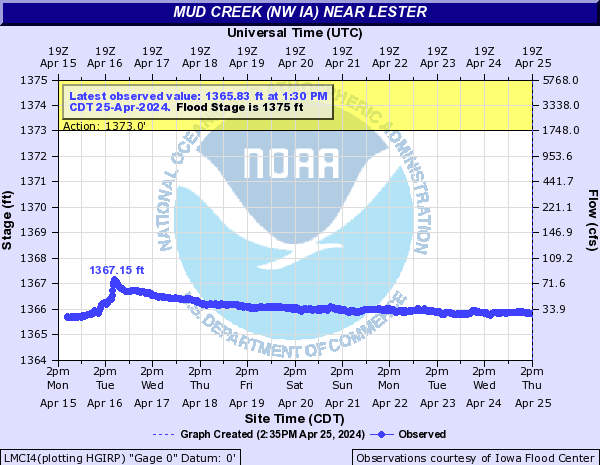
Mud Creek (NW IA) (Click on an image to go to hydrograph webpage)
LMCI4:
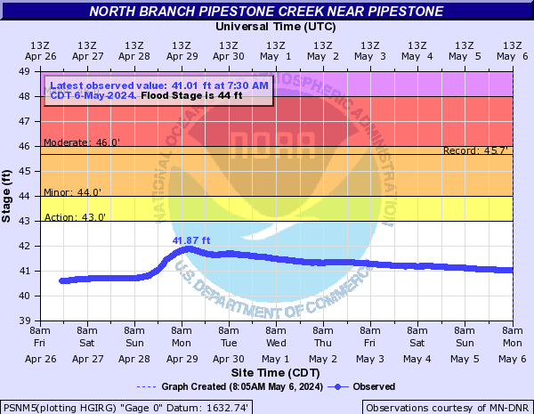
North Branch Pipestone Creek (Click on an image to go to hydrograph webpage)
PSNM5:
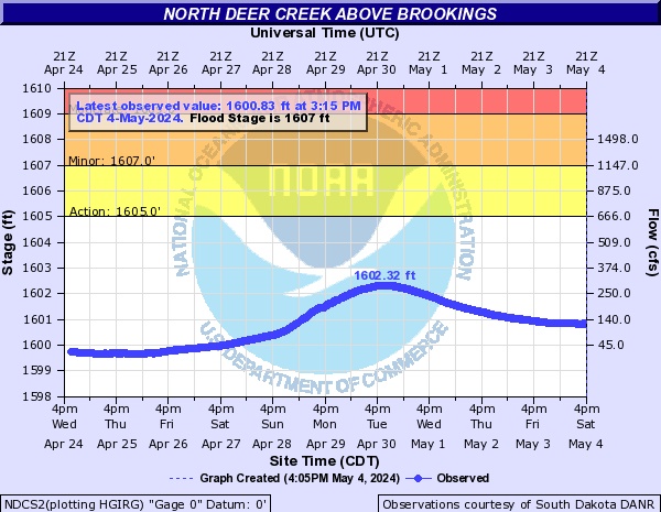
North Deer Creek (Click on an image to go to hydrograph webpage)
NDCS2:
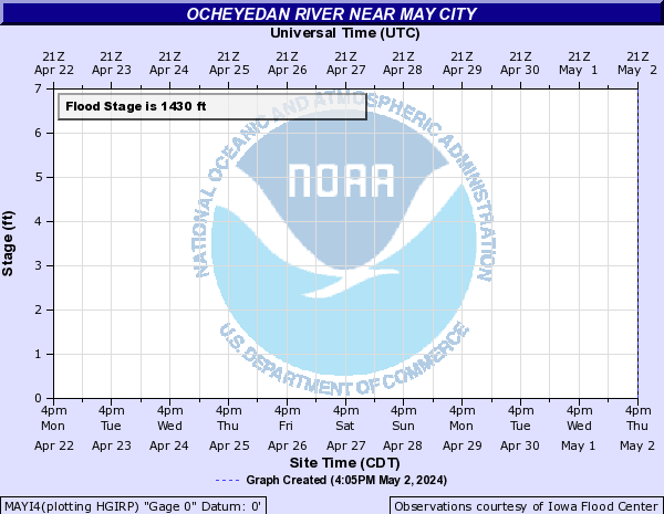
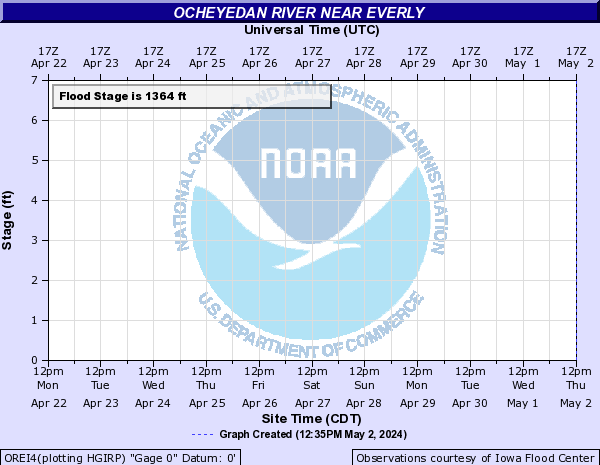
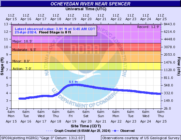
Ocheyedan River (Click on an image to go to hydrograph webpage)
MAYI4:
OREI4:
SPOI4:
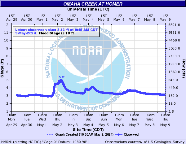
Omaha Creek (Click on an image to go to hydrograph webpage)
HMRN1:
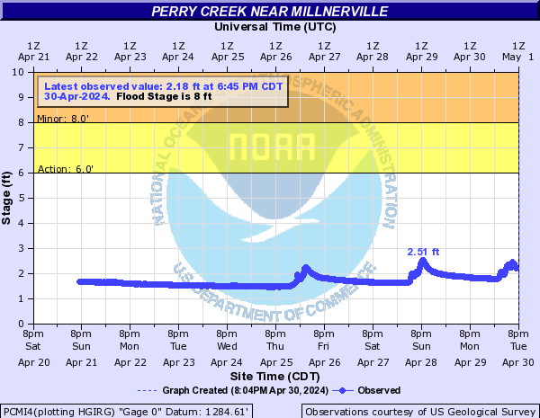
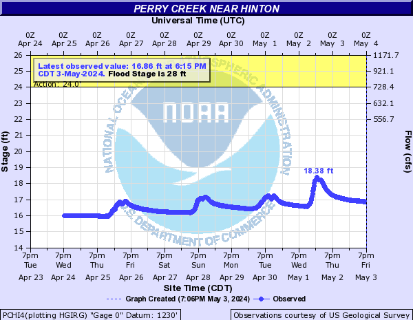
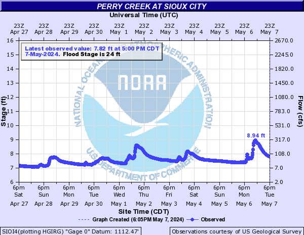
Perry Creek (Click on an image to go to hydrograph webpage)
PCMI4:
PCHI4:
SIOI4:
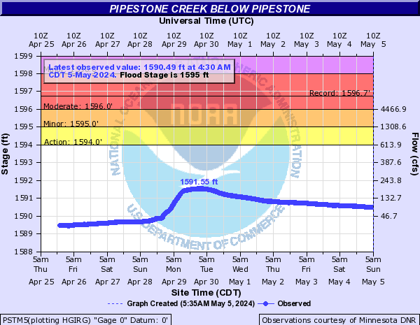
Pipestone Creek (Click on an image to go to hydrograph webpage)
PIPM5:
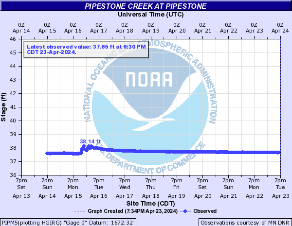
PSTM5:
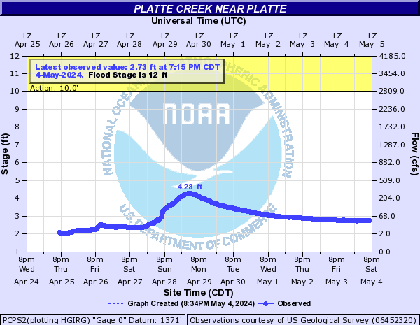
Platte Creek (Click on an image to go to hydrograph webpage)
PCPS2:
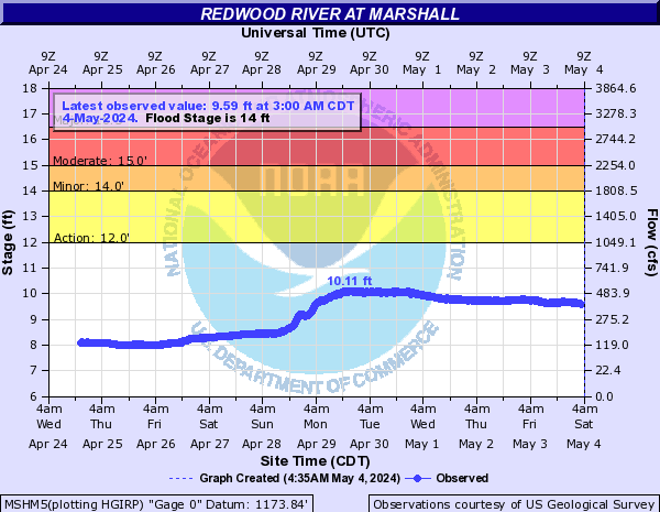
Redwood River (Click on an image to go to hydrograph webpage)
RUSM5:
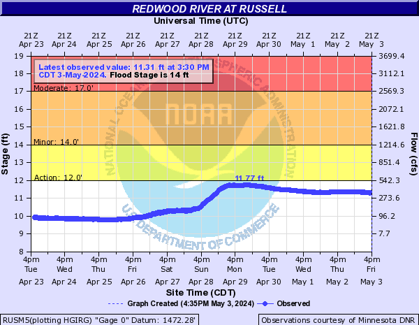
MSHM5:
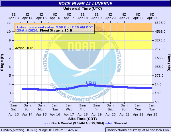
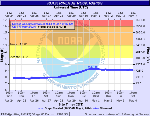
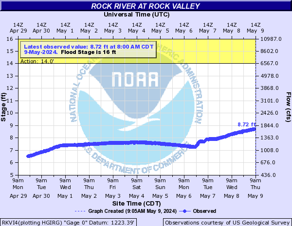
Rock River (Click on an image to go to hydrograph webpage)
HRDM5:

LUVM5:
RAPI4:
RKVI4:
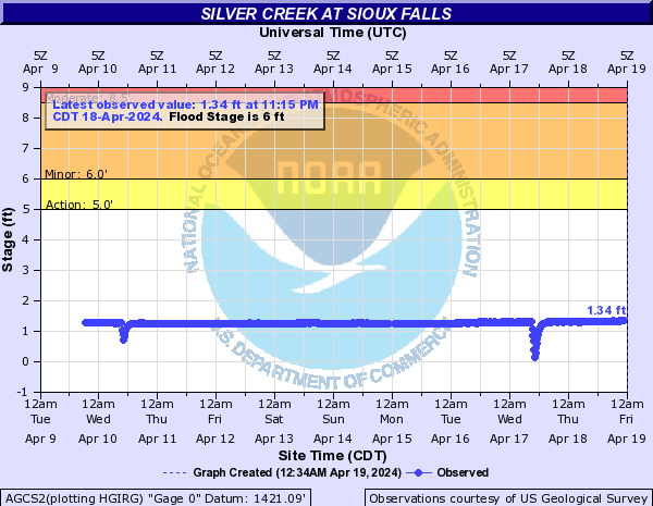
Silver Creek (Click on an image to go to hydrograph webpage)
AGCS2:
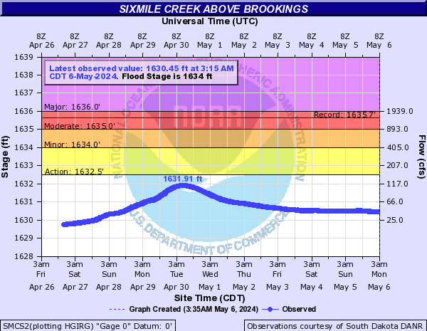
Sixmile Creek (Click on an image to go to hydrograph webpage)
SMCS2:
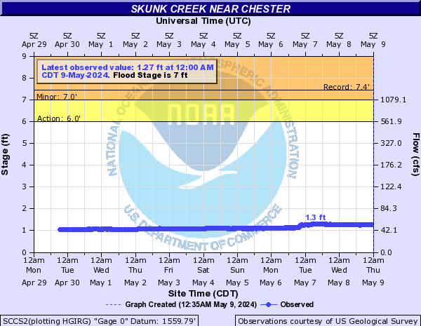
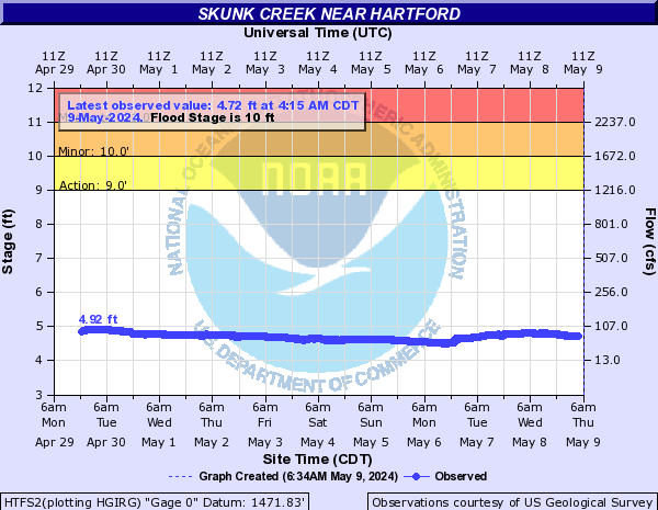
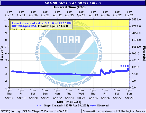
Skunk Creek (Click on an image to go to hydrograph webpage)
SCCS2:
HTFS2:
SIFS2:
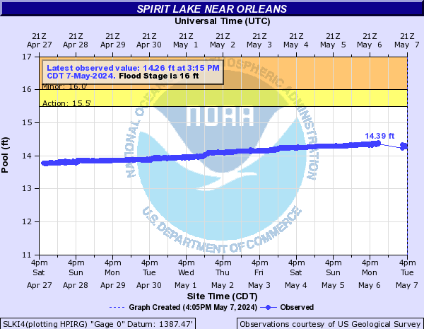
Spirit Lake (Click on an image to go to hydrograph webpage)
SLKI4:
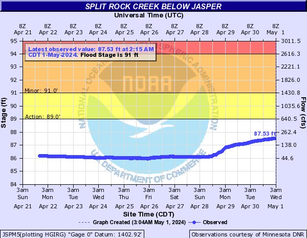
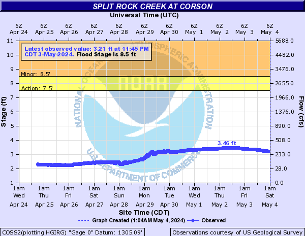
Split Rock Creek (Click on an image to go to hydrograph webpage)
JSPM5:
COSS2:
PALS2:

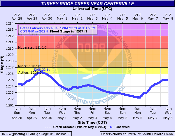
Turkey Ridge Creek (Click on an image to go to hydrograph webpage)
TRCS2:
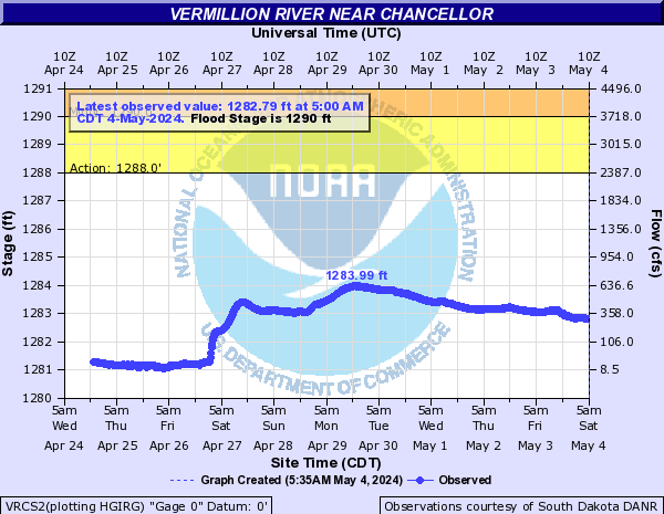
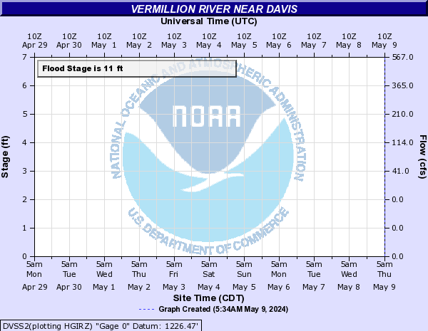
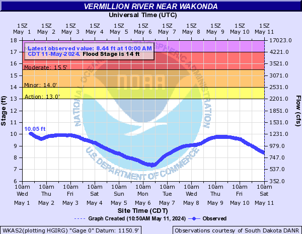
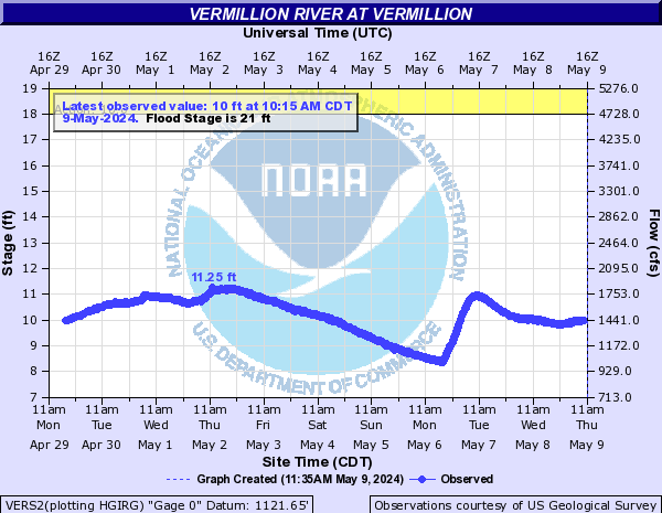
Vermillion River (Click on an image to go to hydrograph webpage)
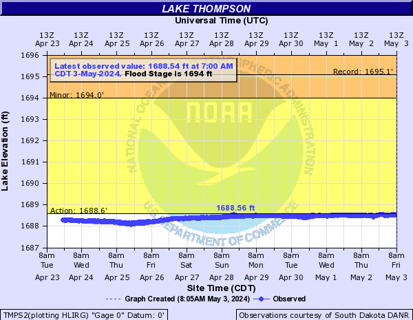
TMPS2:
VRCS2:
DVSS2:
WKAS2:
VERS2:
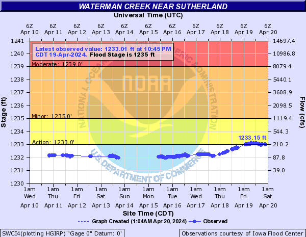
Waterman Creek (Click on an image to go to hydrograph webpage)
SWCI4:
West Branch Floyd River (Click on an image to go to hydrograph webpage)
FRSI4:

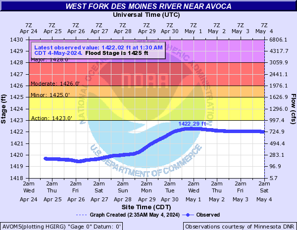
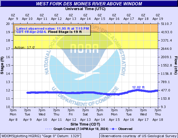
West Fork Des Moines River (Click on an image to go to hydrograph webpage)
AVOM5:
WDOM5:
JCKM5:

West Fork Ditch (Click on an image to go to hydrograph webpage)
WFMI4:

HOKI4:
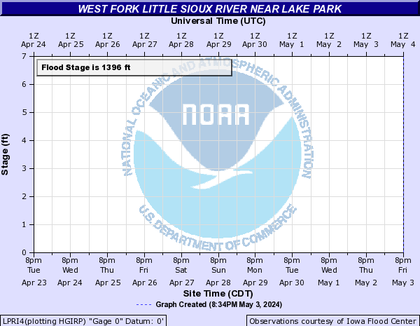
West Fork Little Sioux River (Click on an image to go to hydrograph webpage)
LPRI4:
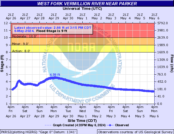
West Fork Vermillion River (Click on an image to go to hydrograph webpage)
PKRS2:
Willow Creek (Click on an image to go to hydrograph webpage)
WCCS2:

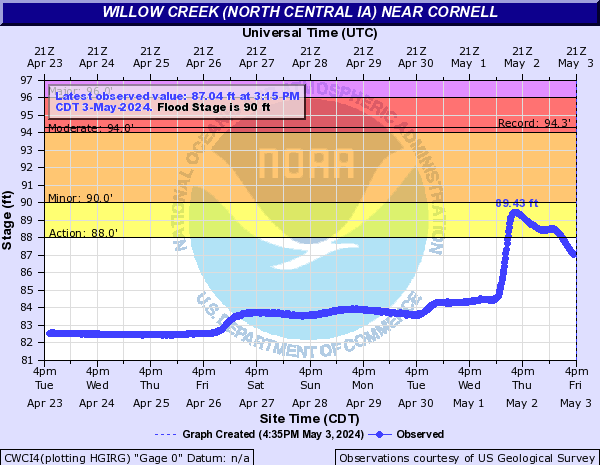
Willow Creek (North Central IA) (Click on an image to go to hydrograph webpage)
CWCI4:
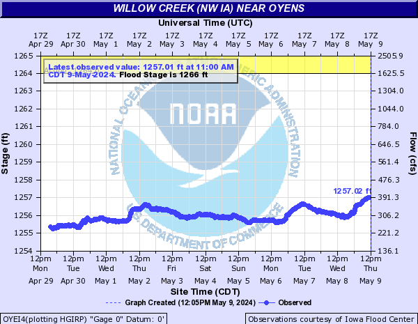
Willow Creek (NW IA) (Click on an image to go to hydrograph webpage)
OYEI4:
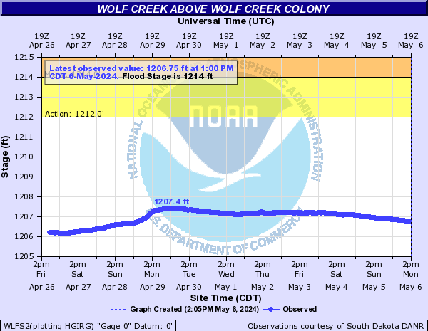
Wolf Creek (SD) (Click on an image to go to hydrograph webpage)
WLFS2: