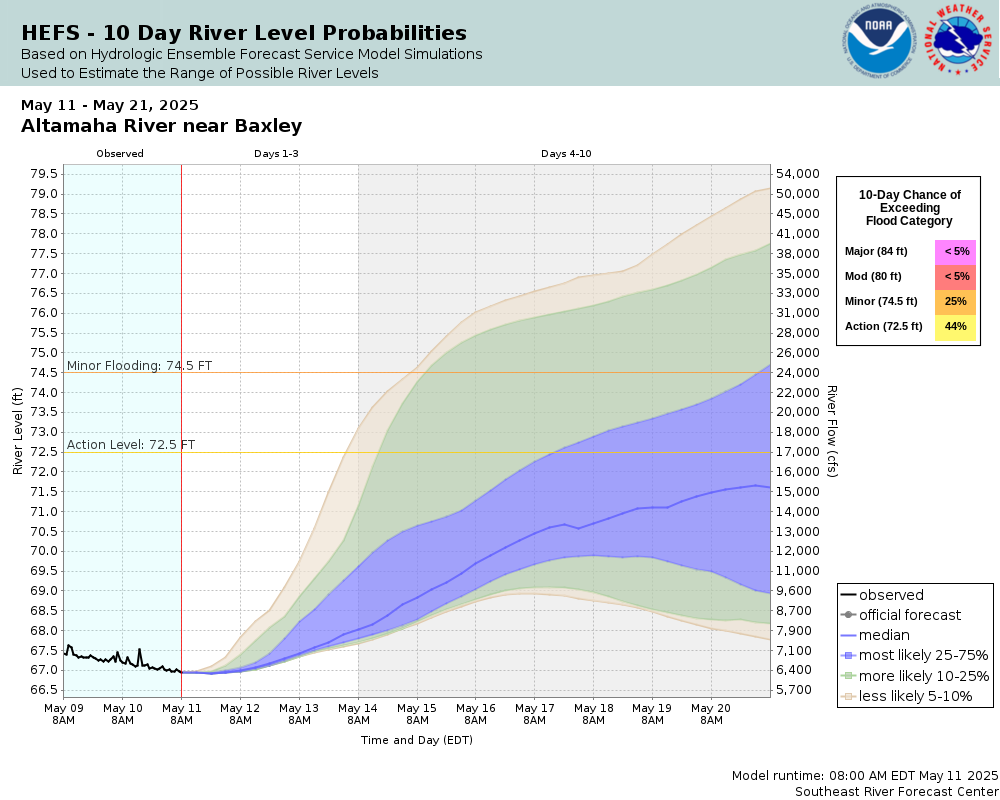
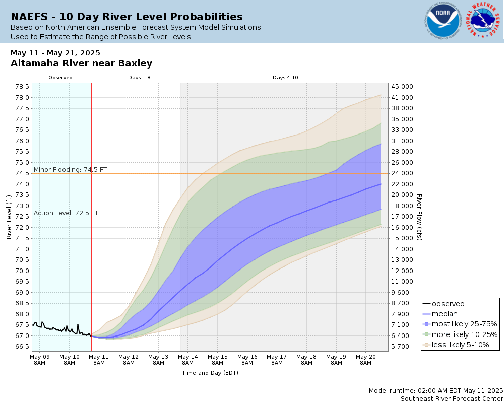
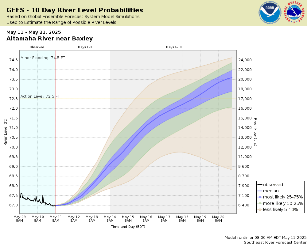
Altamaha River near Baxley
Future / Actual / Minor
OWP 2.0 WWA Modal Title
01/11/2021, 10:04 PM UTC through 01/11/2021, 10:04 PM UTC
Sender
Sent
- Warning: no valid ratings curve available. Transformations to and from FEET/CFS/KCFS will not happen.
Traces and Thresholds Click to turn on/off display
Observed (OBS) 03/17/2025 5:45 PM EDTOfficial Forecast (FCST) 03/17/2025 9:19 AM EDTRecord: 91.5 ftLow Threshold: 63 ftCATEGORY STAGE 
Major Flooding 84 ft Moderate Flooding 80 ft Minor Flooding 74.5 ft Action 72.5 ft Reliability of the Forecast: Based on current and forecast river, weather and reservoir conditions
NOTE: Forecasts are issued routinely year-round.
River forecasts for this location take into account past precipitation and the precipitation amounts expected approximately 48 hours into the future from the forecast issuance time.
National Water Model Hydrograph
Official NWS streamflow forecasts are produced by NWS hydrologic forecasters for river gauge locations using hydrologic models which are calibrated to that location. This process considers additional guidance and information, including local expertise and experience, to produce the best forecast possible. The NWM output provides supplemental guidance to NWS forecasters and should not be considered an official NWS river forecast.
Flood Impacts
- 82 - Water begins to impact homes in the Carters Bight, Davis Landing and Morris Landing areas. Davis Landing Road, Morris Landing Road and Getaway Lane are completely flooded.
- 78 - Deens Landing and Carter Linton Landing are completely flooded. Davis Landing Road, Morris Landing Road and Getaway Lane at Carters Bight Landing begin to flood.
- 74.5 - Flooding of agricultural and timber lands is expected. Deens Landing and Linton Carter Landing boat ramps, picnic areas and parking lots begin to flood.
Gauge Info
| Coordinates | 31.9389, -82.3536 |
| RFC | SERFC |
| State | GA |
| WFO | JAX |
| County | Appling |
| Data Provider(s) | |
| US Geological Survey | USGS--Water Resources of the United States |
| USGS | 02225000 |
Gauge Location
Recent Crests
| 1. | 76.19 ft | on 11-10-2024 |
| 2. | 77.08 ft | on 10-10-2024 |
| 3. | 78.44 ft | on 10-01-2024 |
| 4. | 75.98 ft | on 08-07-2024 |
| 5. | 75.55 ft | on 04-17-2024 |
Recent Crests
| 1. | 76.19 ft | on 11-10-2024 | |
| 2. | 77.08 ft | on 10-10-2024 | |
| 3. | 78.44 ft | on 10-01-2024 | |
| 4. | 75.98 ft | on 08-07-2024 | |
| 5. | 75.55 ft | on 04-17-2024 | |
| 6. | 81.27 ft | on 03-18-2024 | |
| 7. | 80.80 ft | on 02-22-2024 | |
| 8. | 77.55 ft | on 01-21-2024 | |
| 9. | 79.92 ft | on 04-07-2023 | |
| 10. | 76.44 ft | on 02-21-2023 | |
| 11. | 77.02 ft | on 02-15-2023 | |
| 12. | 77.47 ft | on 02-06-2023 | |
| 13. | 79.93 ft | on 04-17-2022 | |
| 14. | 74.56 ft | on 03-27-2022 | |
| 15. | 74.84 ft | on 02-15-2022 | |
| 16. | 76.44 ft | on 01-13-2022 | |
| 17. | 79.53 ft | on 10-17-2021 | |
| 18. | 76.74 ft | on 03-06-2021 | |
| 19. | 79.34 ft | on 02-21-2021 | |
| 20. | 75.90 ft | on 09-28-2020 | |
| 21. | 80.14 ft | on 04-30-2020 | |
| 22. | 74.90 ft | on 04-04-2020 | |
| 23. | 81.78 ft | on 03-13-2020 | |
| 24. | 82.03 ft | on 03-07-2020 | |
| 25. | 83.14 ft | on 02-28-2020 | |
| 26. | 81.10 ft | on 02-16-2020 | |
| 27. | 77.62 ft | on 01-26-2020 | |
| 28. | 77.57 ft | on 01-01-2020 | |
| 29. | 74.59 ft | on 03-13-2019 | |
| 30. | 74.65 ft | on 03-08-2019 | |
| 31. | 77.29 ft | on 02-02-2019 | |
| 32. | 79.91 ft | on 01-14-2019 | |
| 33. | 77.54 ft | on 12-30-2018 | |
| 34. | 78.15 ft | on 12-22-2018 | |
| 35. | 76.09 ft | on 12-11-2018 | |
| 36. | 75.86 ft | on 12-06-2018 | |
| 37. | 76.76 ft | on 11-25-2018 | |
| 38. | 76.26 ft | on 02-01-2017 | |
| 39. | 75.05 ft | on 01-13-2017 | |
| 40. | 78.40 ft | on 04-11-2016 | |
| 41. | 77.55 ft | on 02-11-2016 | |
| 42. | 78.16 ft | on 02-06-2016 | |
| 43. | 76.58 ft | on 02-02-2016 | |
| 44. | 83.74 ft | on 01-06-2016 | |
| 45. | 75.18 ft | on 11-21-2015 | |
| 46. | 77.62 ft | on 05-01-2015 | |
| 47. | 76.87 ft | on 03-06-2015 | |
| 48. | 74.63 ft | on 01-02-2015 | |
| 49. | 73.81 ft | on 05-22-2014 | |
| 50. | 78.42 ft | on 04-22-2014 | |
| 51. | 74.97 ft | on 03-27-2014 | |
| 52. | 75.90 ft | on 02-21-2014 | |
| 53. | 76.66 ft | on 01-22-2014 | |
| 54. | 78.04 ft | on 01-07-2014 | |
| 55. | 77.64 ft | on 08-27-2013 | |
| 56. | 77.38 ft | on 08-23-2013 | |
| 57. | 77.84 ft | on 07-19-2013 | |
| 58. | 76.83 ft | on 07-14-2013 | |
| 59. | 75.76 ft | on 05-16-2013 | |
| 60. | 75.61 ft | on 04-03-2013 | |
| 61. | 78.99 ft | on 03-07-2013 | |
| 62. | 79.23 ft | on 02-28-2013 | |
| 63. | 75.15 ft | on 02-22-2013 | |
| 64. | 69.08 ft | on 03-08-2012 | |
| 65. | 74.52 ft | on 04-10-2011 | |
| 66. | 75.53 ft | on 02-14-2011 | |
| 67. | 74.79 ft | on 05-09-2010 | |
| 68. | 77.88 ft | on 03-23-2010 | |
| 69. | 79.54 ft | on 02-16-2010 | |
| 70. | 80.42 ft | on 02-05-2010 | |
| 71. | 79.28 ft | on 01-25-2010 | |
| 72. | 80.33 ft | on 12-27-2009 | |
| 73. | 80.56 ft | on 12-21-2009 | |
| 74. | 80.11 ft | on 12-17-2009 | |
| 75. | 78.61 ft | on 11-23-2009 | |
| 76. | 75.83 ft | on 10-25-2009 | |
| 77. | 76.52 ft | on 10-05-2009 | |
| 78. | 83.68 ft | on 04-11-2009 | |
| 79. | 75.94 ft | on 03-12-2009 | |
| 80. | 74.73 ft | on 12-22-2008 | |
| 81. | 74.65 ft | on 03-12-2008 | |
| 82. | 74.43 ft | on 02-25-2008 | |
| 83. | 76.12 ft | on 03-13-2007 | |
| 84. | 74.27 ft | on 03-06-2006 | |
| 85. | 77.11 ft | on 07-23-2005 | |
| 86. | 82.16 ft | on 04-05-2005 | |
| 87. | 73.71 ft | on 12-05-2004 | |
| 88. | 78.74 ft | on 10-07-2004 | |
| 89. | 74.05 ft | on 09-22-2004 | |
| 90. | 75.20 ft | on 09-17-2004 | |
| 91. | 74.35 ft | on 09-09-2004 | |
| 92. | 73.76 ft | on 03-02-2004 | |
| 93. | 75.39 ft | on 02-21-2004 | |
| 94. | 73.70 ft | on 08-14-2003 | |
| 95. | 73.82 ft | on 08-08-2003 | |
| 96. | 76.87 ft | on 07-15-2003 | |
| 97. | 76.01 ft | on 06-22-2003 | |
| 98. | 77.11 ft | on 06-02-2003 | |
| 99. | 74.94 ft | on 05-22-2003 | |
| 100. | 74.29 ft | on 05-18-2003 | |
| 101. | 75.93 ft | on 04-18-2003 | |
| 102. | 79.68 ft | on 03-29-2003 | |
| 103. | 79.17 ft | on 03-22-2003 | |
| 104. | 76.63 ft | on 03-09-2003 | |
| 105. | 74.67 ft | on 01-04-2003 | |
| 106. | 75.19 ft | on 06-23-2001 | |
| 107. | 79.68 ft | on 03-26-2001 | |
| 108. | 77.36 ft | on 03-18-2001 | |
| 109. | 76.10 ft | on 02-12-1999 | |
| 110. | 79.15 ft | on 04-25-1998 | |
| 111. | 79.08 ft | on 04-18-1998 | |
| 112. | 78.88 ft | on 04-13-1998 | |
| 113. | 85.66 ft | on 03-16-1998 | |
| 114. | 78.79 ft | on 03-01-1998 | |
| 115. | 84.53 ft | on 02-12-1998 | |
| 116. | 79.62 ft | on 01-26-1998 | |
| 117. | 78.27 ft | on 01-19-1998 | |
| 118. | 82.54 ft | on 01-03-1998 | |
| 119. | 77.28 ft | on 12-18-1997 | |
| 120. | 76.13 ft | on 12-05-1997 | |
| 121. | 74.23 ft | on 11-22-1997 | |
| 122. | 74.91 ft | on 11-07-1997 | |
| 123. | 78.31 ft | on 03-13-1997 | |
| 124. | 79.15 ft | on 02-27-1997 | |
| 125. | 74.26 ft | on 01-20-1997 | |
| 126. | 76.89 ft | on 03-30-1996 | |
| 127. | 80.29 ft | on 03-18-1996 | |
| 128. | 80.16 ft | on 02-12-1996 | |
| 129. | 74.55 ft | on 11-24-1995 | |
| 130. | 75.40 ft | on 06-12-1995 | |
| 131. | 76.99 ft | on 03-20-1995 | |
| 132. | 81.94 ft | on 02-26-1995 | |
| 133. | 77.63 ft | on 02-15-1995 | |
| 134. | 75.37 ft | on 01-23-1995 | |
| 135. | 75.55 ft | on 01-17-1995 | |
| 136. | 75.93 ft | on 12-13-1994 | |
| 137. | 75.72 ft | on 12-09-1994 | |
| 138. | 77.92 ft | on 10-23-1994 | |
| 139. | 73.73 ft | on 10-08-1994 | |
| 140. | 77.09 ft | on 08-29-1994 | |
| 141. | 84.09 ft | on 07-16-1994 | |
| 142. | 75.57 ft | on 04-07-1994 | |
| 143. | 77.11 ft | on 03-12-1994 | |
| 144. | 74.26 ft | on 02-20-1994 | |
| 145. | 80.95 ft | on 04-07-1993 | |
| 146. | 78.50 ft | on 03-28-1993 | |
| 147. | 78.47 ft | on 03-11-1993 | |
| 148. | 78.37 ft | on 03-08-1993 | |
| 149. | 75.27 ft | on 02-22-1993 | |
| 150. | 81.39 ft | on 01-15-1993 | |
| 151. | 75.42 ft | on 01-01-1993 | |
| 152. | 80.42 ft | on 12-08-1992 | |
| 153. | 74.58 ft | on 11-30-1992 | |
| 154. | 74.08 ft | on 04-03-1992 | |
| 155. | 73.73 ft | on 03-23-1992 | |
| 156. | 75.50 ft | on 03-14-1992 | |
| 157. | 77.28 ft | on 02-28-1992 | |
| 158. | 74.20 ft | on 02-09-1992 | |
| 159. | 73.83 ft | on 08-04-1991 | |
| 160. | 74.77 ft | on 05-20-1991 | |
| 161. | 75.72 ft | on 04-10-1991 | |
| 162. | 80.55 ft | on 03-10-1991 | |
| 163. | 79.61 ft | on 02-08-1991 | |
| 164. | 80.86 ft | on 03-28-1990 | |
| 165. | 79.22 ft | on 03-01-1990 | |
| 166. | 75.27 ft | on 02-08-1990 | |
| 167. | 74.29 ft | on 02-01-1990 | |
| 168. | 77.80 ft | on 01-11-1990 | |
| 169. | 78.24 ft | on 10-12-1989 | |
| 170. | 75.77 ft | on 04-21-1989 | |
| 171. | 76.42 ft | on 04-11-1987 | |
| 172. | 79.84 ft | on 03-12-1987 | |
| 173. | 74.77 ft | on 02-20-1987 | |
| 174. | 80.01 ft | on 01-28-1987 | |
| 175. | 76.95 ft | on 01-08-1987 | |
| 176. | 73.70 ft | on 12-16-1986 | |
| 177. | 76.11 ft | on 02-13-1986 | |
| 178. | 74.46 ft | on 12-17-1985 | |
| 179. | 73.77 ft | on 11-26-1985 | |
| 180. | 78.71 ft | on 02-16-1985 | |
| 181. | 77.72 ft | on 08-13-1984 | |
| 182. | 75.42 ft | on 05-13-1984 | |
| 183. | 76.48 ft | on 05-06-1984 | |
| 184. | 74.05 ft | on 05-01-1984 | |
| 185. | 74.85 ft | on 04-30-1984 | |
| 186. | 76.06 ft | on 04-11-1984 | |
| 187. | 76.52 ft | on 04-07-1984 | |
| 188. | 79.38 ft | on 03-09-1984 | |
| 189. | 75.32 ft | on 03-01-1984 | |
| 190. | 74.29 ft | on 02-24-1984 | |
| 191. | 78.54 ft | on 01-29-1984 | |
| 192. | 74.08 ft | on 01-22-1984 | |
| 193. | 78.48 ft | on 12-18-1983 | |
| 194. | 80.59 ft | on 04-19-1983 | |
| 195. | 78.19 ft | on 04-07-1983 | |
| 196. | 78.73 ft | on 03-15-1983 | |
| 197. | 78.47 ft | on 02-24-1983 | |
| 198. | 75.01 ft | on 01-12-1983 | |
| 199. | 74.11 ft | on 01-05-1983 | |
| 200. | 74.49 ft | on 05-05-1982 | |
| 201. | 74.77 ft | on 02-25-1982 | |
| 202. | 79.61 ft | on 02-15-1982 | |
| 203. | 78.13 ft | on 01-15-1982 | |
| 204. | 75.76 ft | on 04-10-1981 | |
| 205. | 77.49 ft | on 02-22-1981 | |
| 206. | 75.35 ft | on 06-03-1980 | |
| 207. | 75.69 ft | on 04-26-1980 | |
| 208. | 81.49 ft | on 04-08-1980 | |
| 209. | 83.20 ft | on 03-21-1980 | |
| 210. | 74.85 ft | on 01-31-1980 | |
| 211. | 74.66 ft | on 05-04-1979 | |
| 212. | 78.29 ft | on 04-26-1979 | |
| 213. | 82.46 ft | on 03-06-1979 | |
| 214. | 75.69 ft | on 05-19-1978 | |
| 215. | 75.09 ft | on 03-21-1978 | |
| 216. | 82.16 ft | on 02-05-1978 | |
| 217. | 79.01 ft | on 04-02-1977 | |
| 218. | 78.26 ft | on 03-14-1977 | |
| 219. | 75.93 ft | on 01-21-1977 | |
| 220. | 75.69 ft | on 01-07-1977 | |
| 221. | 73.80 ft | on 01-02-1977 | |
| 222. | 75.69 ft | on 12-23-1976 | |
| 223. | 74.66 ft | on 12-16-1976 | |
| 224. | 73.99 ft | on 12-08-1976 | |
| 225. | 73.70 ft | on 12-03-1976 | |
| 226. | 76.13 ft | on 06-11-1976 | |
| 227. | 78.64 ft | on 05-27-1976 | |
| 228. | 80.13 ft | on 03-28-1976 | |
| 229. | 74.63 ft | on 02-09-1976 | |
| 230. | 74.02 ft | on 05-26-1975 | |
| 231. | 74.83 ft | on 05-13-1975 | |
| 232. | 80.11 ft | on 04-16-1975 | |
| 233. | 83.73 ft | on 03-26-1975 | |
| 234. | 80.65 ft | on 02-28-1975 | |
| 235. | 73.77 ft | on 02-06-1975 | |
| 236. | 76.87 ft | on 01-25-1975 | |
| 237. | 78.39 ft | on 04-16-1974 | |
| 238. | 79.21 ft | on 02-26-1974 | |
| 239. | 78.18 ft | on 02-19-1974 | |
| 240. | 75.42 ft | on 06-13-1973 | |
| 241. | 76.18 ft | on 05-05-1973 | |
| 242. | 80.18 ft | on 04-14-1973 | |
| 243. | 78.26 ft | on 04-04-1973 | |
| 244. | 77.18 ft | on 03-29-1973 | |
| 245. | 74.72 ft | on 03-13-1973 | |
| 246. | 79.93 ft | on 02-12-1973 | |
| 247. | 76.42 ft | on 01-20-1973 | |
| 248. | 74.14 ft | on 01-02-1973 | |
| 249. | 78.74 ft | on 02-10-1972 | |
| 250. | 81.69 ft | on 01-23-1972 | |
| 251. | 73.89 ft | on 05-25-1971 | |
| 252. | 73.83 ft | on 05-04-1971 | |
| 253. | 78.95 ft | on 04-06-1971 | |
| 254. | 84.19 ft | on 03-12-1971 | |
| 255. | 76.61 ft | on 02-19-1971 | |
| 256. | 74.08 ft | on 01-16-1971 | |
| 257. | 74.31 ft | on 04-02-1951 | |
| 258. | 74.41 ft | on 03-21-1950 | |
| 259. | 74.49 ft | on 09-02-1949 | |
| 260. | 86.61 ft | on 12-10-1948 | |
| 261. | 81.81 ft | on 04-05-1948 | |
| 262. | 80.71 ft | on 03-18-1947 | |
| 263. | 79.91 ft | on 01-19-1946 | |
| 264. | 77.51 ft | on 05-08-1945 | |
| 265. | 86.01 ft | on 04-01-1944 | |
| 266. | 89.00 ft | on 04-12-1936 | (P) |
| 267. | 86.61 ft | on 10-09-1929 | |
| 268. | 88.91 ft | on 03-11-1929 | |
| 269. | 86.81 ft | on 08-23-1928 | |
| 270. | 91.51 ft | on 01-22-1925 |
Historic Crests
| 1. | 91.51 ft | on 01-22-1925 | |
| 2. | 89.00 ft | on 04-12-1936 | (P) |
| 3. | 88.91 ft | on 03-11-1929 | |
| 4. | 86.81 ft | on 08-23-1928 | |
| 5. | 86.61 ft | on 10-09-1929 |
Historic Crests
| 1. | 91.51 ft | on 01-22-1925 | |
| 2. | 89.00 ft | on 04-12-1936 | (P) |
| 3. | 88.91 ft | on 03-11-1929 | |
| 4. | 86.81 ft | on 08-23-1928 | |
| 5. | 86.61 ft | on 10-09-1929 | |
| 6. | 86.61 ft | on 12-10-1948 | |
| 7. | 86.01 ft | on 04-01-1944 | |
| 8. | 85.66 ft | on 03-16-1998 | |
| 9. | 84.53 ft | on 02-12-1998 | |
| 10. | 84.19 ft | on 03-12-1971 | |
| 11. | 84.09 ft | on 07-16-1994 | |
| 12. | 83.74 ft | on 01-06-2016 | |
| 13. | 83.73 ft | on 03-26-1975 | |
| 14. | 83.68 ft | on 04-11-2009 | |
| 15. | 83.20 ft | on 03-21-1980 | |
| 16. | 83.14 ft | on 02-28-2020 | |
| 17. | 82.54 ft | on 01-03-1998 | |
| 18. | 82.46 ft | on 03-06-1979 | |
| 19. | 82.16 ft | on 04-05-2005 | |
| 20. | 82.16 ft | on 02-05-1978 | |
| 21. | 82.03 ft | on 03-07-2020 | |
| 22. | 81.94 ft | on 02-26-1995 | |
| 23. | 81.81 ft | on 04-05-1948 | |
| 24. | 81.78 ft | on 03-13-2020 | |
| 25. | 81.69 ft | on 01-23-1972 | |
| 26. | 81.49 ft | on 04-08-1980 | |
| 27. | 81.39 ft | on 01-15-1993 | |
| 28. | 81.27 ft | on 03-18-2024 | |
| 29. | 81.10 ft | on 02-16-2020 | |
| 30. | 80.95 ft | on 04-07-1993 | |
| 31. | 80.86 ft | on 03-28-1990 | |
| 32. | 80.80 ft | on 02-22-2024 | |
| 33. | 80.71 ft | on 03-18-1947 | |
| 34. | 80.65 ft | on 02-28-1975 | |
| 35. | 80.59 ft | on 04-19-1983 | |
| 36. | 80.56 ft | on 12-21-2009 | |
| 37. | 80.55 ft | on 03-10-1991 | |
| 38. | 80.42 ft | on 02-05-2010 | |
| 39. | 80.42 ft | on 12-08-1992 | |
| 40. | 80.33 ft | on 12-27-2009 | |
| 41. | 80.29 ft | on 03-18-1996 | |
| 42. | 80.18 ft | on 04-14-1973 | |
| 43. | 80.16 ft | on 02-12-1996 | |
| 44. | 80.14 ft | on 04-30-2020 | |
| 45. | 80.13 ft | on 03-28-1976 | |
| 46. | 80.11 ft | on 12-17-2009 | |
| 47. | 80.11 ft | on 04-16-1975 | |
| 48. | 80.01 ft | on 01-28-1987 | |
| 49. | 79.93 ft | on 02-12-1973 | |
| 50. | 79.93 ft | on 04-17-2022 | |
| 51. | 79.92 ft | on 04-07-2023 | |
| 52. | 79.91 ft | on 01-19-1946 | |
| 53. | 79.91 ft | on 01-14-2019 | |
| 54. | 79.84 ft | on 03-12-1987 | |
| 55. | 79.68 ft | on 03-29-2003 | |
| 56. | 79.68 ft | on 03-26-2001 | |
| 57. | 79.62 ft | on 01-26-1998 | |
| 58. | 79.61 ft | on 02-08-1991 | |
| 59. | 79.61 ft | on 02-15-1982 | |
| 60. | 79.54 ft | on 02-16-2010 | |
| 61. | 79.53 ft | on 10-17-2021 | |
| 62. | 79.38 ft | on 03-09-1984 | |
| 63. | 79.34 ft | on 02-21-2021 | |
| 64. | 79.28 ft | on 01-25-2010 | |
| 65. | 79.23 ft | on 02-28-2013 | |
| 66. | 79.22 ft | on 03-01-1990 | |
| 67. | 79.21 ft | on 02-26-1974 | |
| 68. | 79.17 ft | on 03-22-2003 | |
| 69. | 79.15 ft | on 04-25-1998 | |
| 70. | 79.15 ft | on 02-27-1997 | |
| 71. | 79.08 ft | on 04-18-1998 | |
| 72. | 79.01 ft | on 04-02-1977 | |
| 73. | 78.99 ft | on 03-07-2013 | |
| 74. | 78.95 ft | on 04-06-1971 | |
| 75. | 78.88 ft | on 04-13-1998 | |
| 76. | 78.79 ft | on 03-01-1998 | |
| 77. | 78.74 ft | on 02-10-1972 | |
| 78. | 78.74 ft | on 10-07-2004 | |
| 79. | 78.73 ft | on 03-15-1983 | |
| 80. | 78.71 ft | on 02-16-1985 | |
| 81. | 78.64 ft | on 05-27-1976 | |
| 82. | 78.61 ft | on 11-23-2009 | |
| 83. | 78.54 ft | on 01-29-1984 | |
| 84. | 78.50 ft | on 03-28-1993 | |
| 85. | 78.48 ft | on 12-18-1983 | |
| 86. | 78.47 ft | on 02-24-1983 | |
| 87. | 78.47 ft | on 03-11-1993 | |
| 88. | 78.44 ft | on 10-01-2024 | |
| 89. | 78.42 ft | on 04-22-2014 | |
| 90. | 78.40 ft | on 04-11-2016 | |
| 91. | 78.39 ft | on 04-16-1974 | |
| 92. | 78.37 ft | on 03-08-1993 | |
| 93. | 78.31 ft | on 03-13-1997 | |
| 94. | 78.29 ft | on 04-26-1979 | |
| 95. | 78.27 ft | on 01-19-1998 | |
| 96. | 78.26 ft | on 03-14-1977 | |
| 97. | 78.26 ft | on 04-04-1973 | |
| 98. | 78.24 ft | on 10-12-1989 | |
| 99. | 78.19 ft | on 04-07-1983 | |
| 100. | 78.18 ft | on 02-19-1974 | |
| 101. | 78.16 ft | on 02-06-2016 | |
| 102. | 78.15 ft | on 12-22-2018 | |
| 103. | 78.13 ft | on 01-15-1982 | |
| 104. | 78.04 ft | on 01-07-2014 | |
| 105. | 77.92 ft | on 10-23-1994 | |
| 106. | 77.88 ft | on 03-23-2010 | |
| 107. | 77.84 ft | on 07-19-2013 | |
| 108. | 77.80 ft | on 01-11-1990 | |
| 109. | 77.72 ft | on 08-13-1984 | |
| 110. | 77.64 ft | on 08-27-2013 | |
| 111. | 77.63 ft | on 02-15-1995 | |
| 112. | 77.62 ft | on 05-01-2015 | |
| 113. | 77.62 ft | on 01-26-2020 | |
| 114. | 77.57 ft | on 01-01-2020 | |
| 115. | 77.55 ft | on 02-11-2016 | |
| 116. | 77.55 ft | on 01-21-2024 | |
| 117. | 77.54 ft | on 12-30-2018 | |
| 118. | 77.51 ft | on 05-08-1945 | |
| 119. | 77.49 ft | on 02-22-1981 | |
| 120. | 77.47 ft | on 02-06-2023 | |
| 121. | 77.38 ft | on 08-23-2013 | |
| 122. | 77.36 ft | on 03-18-2001 | |
| 123. | 77.29 ft | on 02-02-2019 | |
| 124. | 77.28 ft | on 02-28-1992 | |
| 125. | 77.28 ft | on 12-18-1997 | |
| 126. | 77.18 ft | on 03-29-1973 | |
| 127. | 77.11 ft | on 06-02-2003 | |
| 128. | 77.11 ft | on 07-23-2005 | |
| 129. | 77.11 ft | on 03-12-1994 | |
| 130. | 77.09 ft | on 08-29-1994 | |
| 131. | 77.08 ft | on 10-10-2024 | |
| 132. | 77.02 ft | on 02-15-2023 | |
| 133. | 76.99 ft | on 03-20-1995 | |
| 134. | 76.95 ft | on 01-08-1987 | |
| 135. | 76.89 ft | on 03-30-1996 | |
| 136. | 76.87 ft | on 07-15-2003 | |
| 137. | 76.87 ft | on 03-06-2015 | |
| 138. | 76.87 ft | on 01-25-1975 | |
| 139. | 76.83 ft | on 07-14-2013 | |
| 140. | 76.76 ft | on 11-25-2018 | |
| 141. | 76.74 ft | on 03-06-2021 | |
| 142. | 76.66 ft | on 01-22-2014 | |
| 143. | 76.63 ft | on 03-09-2003 | |
| 144. | 76.61 ft | on 02-19-1971 | |
| 145. | 76.58 ft | on 02-02-2016 | |
| 146. | 76.52 ft | on 10-05-2009 | |
| 147. | 76.52 ft | on 04-07-1984 | |
| 148. | 76.48 ft | on 05-06-1984 | |
| 149. | 76.44 ft | on 02-21-2023 | |
| 150. | 76.44 ft | on 01-13-2022 | |
| 151. | 76.42 ft | on 01-20-1973 | |
| 152. | 76.42 ft | on 04-11-1987 | |
| 153. | 76.26 ft | on 02-01-2017 | |
| 154. | 76.19 ft | on 11-10-2024 | |
| 155. | 76.18 ft | on 05-05-1973 | |
| 156. | 76.13 ft | on 12-05-1997 | |
| 157. | 76.13 ft | on 06-11-1976 | |
| 158. | 76.12 ft | on 03-13-2007 | |
| 159. | 76.11 ft | on 02-13-1986 | |
| 160. | 76.10 ft | on 02-12-1999 | |
| 161. | 76.09 ft | on 12-11-2018 | |
| 162. | 76.06 ft | on 04-11-1984 | |
| 163. | 76.01 ft | on 06-22-2003 | |
| 164. | 75.98 ft | on 08-07-2024 | |
| 165. | 75.94 ft | on 03-12-2009 | |
| 166. | 75.93 ft | on 04-18-2003 | |
| 167. | 75.93 ft | on 01-21-1977 | |
| 168. | 75.93 ft | on 12-13-1994 | |
| 169. | 75.90 ft | on 09-28-2020 | |
| 170. | 75.90 ft | on 02-21-2014 | |
| 171. | 75.86 ft | on 12-06-2018 | |
| 172. | 75.83 ft | on 10-25-2009 | |
| 173. | 75.77 ft | on 04-21-1989 | |
| 174. | 75.76 ft | on 04-10-1981 | |
| 175. | 75.76 ft | on 05-16-2013 | |
| 176. | 75.72 ft | on 12-09-1994 | |
| 177. | 75.72 ft | on 04-10-1991 | |
| 178. | 75.69 ft | on 04-26-1980 | |
| 179. | 75.69 ft | on 05-19-1978 | |
| 180. | 75.69 ft | on 01-07-1977 | |
| 181. | 75.69 ft | on 12-23-1976 | |
| 182. | 75.61 ft | on 04-03-2013 | |
| 183. | 75.57 ft | on 04-07-1994 | |
| 184. | 75.55 ft | on 01-17-1995 | |
| 185. | 75.55 ft | on 04-17-2024 | |
| 186. | 75.53 ft | on 02-14-2011 | |
| 187. | 75.50 ft | on 03-14-1992 | |
| 188. | 75.42 ft | on 05-13-1984 | |
| 189. | 75.42 ft | on 01-01-1993 | |
| 190. | 75.42 ft | on 06-13-1973 | |
| 191. | 75.40 ft | on 06-12-1995 | |
| 192. | 75.39 ft | on 02-21-2004 | |
| 193. | 75.37 ft | on 01-23-1995 | |
| 194. | 75.35 ft | on 06-03-1980 | |
| 195. | 75.32 ft | on 03-01-1984 | |
| 196. | 75.27 ft | on 02-22-1993 | |
| 197. | 75.27 ft | on 02-08-1990 | |
| 198. | 75.20 ft | on 09-17-2004 | |
| 199. | 75.19 ft | on 06-23-2001 | |
| 200. | 75.18 ft | on 11-21-2015 | |
| 201. | 75.15 ft | on 02-22-2013 | |
| 202. | 75.09 ft | on 03-21-1978 | |
| 203. | 75.05 ft | on 01-13-2017 | |
| 204. | 75.01 ft | on 01-12-1983 | |
| 205. | 74.97 ft | on 03-27-2014 | |
| 206. | 74.94 ft | on 05-22-2003 | |
| 207. | 74.91 ft | on 11-07-1997 | |
| 208. | 74.90 ft | on 04-04-2020 | |
| 209. | 74.85 ft | on 04-30-1984 | |
| 210. | 74.85 ft | on 01-31-1980 | |
| 211. | 74.84 ft | on 02-15-2022 | |
| 212. | 74.83 ft | on 05-13-1975 | |
| 213. | 74.79 ft | on 05-09-2010 | |
| 214. | 74.77 ft | on 02-25-1982 | |
| 215. | 74.77 ft | on 05-20-1991 | |
| 216. | 74.77 ft | on 02-20-1987 | |
| 217. | 74.73 ft | on 12-22-2008 | |
| 218. | 74.72 ft | on 03-13-1973 | |
| 219. | 74.67 ft | on 01-04-2003 | |
| 220. | 74.66 ft | on 05-04-1979 | |
| 221. | 74.66 ft | on 12-16-1976 | |
| 222. | 74.65 ft | on 03-12-2008 | |
| 223. | 74.65 ft | on 03-08-2019 | |
| 224. | 74.63 ft | on 02-09-1976 | |
| 225. | 74.63 ft | on 01-02-2015 | |
| 226. | 74.59 ft | on 03-13-2019 | |
| 227. | 74.58 ft | on 11-30-1992 | |
| 228. | 74.56 ft | on 03-27-2022 | |
| 229. | 74.55 ft | on 11-24-1995 | |
| 230. | 74.52 ft | on 04-10-2011 | |
| 231. | 74.49 ft | on 05-05-1982 | |
| 232. | 74.49 ft | on 09-02-1949 | |
| 233. | 74.46 ft | on 12-17-1985 | |
| 234. | 74.43 ft | on 02-25-2008 | |
| 235. | 74.41 ft | on 03-21-1950 | |
| 236. | 74.35 ft | on 09-09-2004 | |
| 237. | 74.31 ft | on 04-02-1951 | |
| 238. | 74.29 ft | on 05-18-2003 | |
| 239. | 74.29 ft | on 02-01-1990 | |
| 240. | 74.29 ft | on 02-24-1984 | |
| 241. | 74.27 ft | on 03-06-2006 | |
| 242. | 74.26 ft | on 01-20-1997 | |
| 243. | 74.26 ft | on 02-20-1994 | |
| 244. | 74.23 ft | on 11-22-1997 | |
| 245. | 74.20 ft | on 02-09-1992 | |
| 246. | 74.14 ft | on 01-02-1973 | |
| 247. | 74.11 ft | on 01-05-1983 | |
| 248. | 74.08 ft | on 01-22-1984 | |
| 249. | 74.08 ft | on 01-16-1971 | |
| 250. | 74.08 ft | on 04-03-1992 | |
| 251. | 74.05 ft | on 09-22-2004 | |
| 252. | 74.05 ft | on 05-01-1984 | |
| 253. | 74.02 ft | on 05-26-1975 | |
| 254. | 73.99 ft | on 12-08-1976 | |
| 255. | 73.89 ft | on 05-25-1971 | |
| 256. | 73.83 ft | on 08-04-1991 | |
| 257. | 73.83 ft | on 05-04-1971 | |
| 258. | 73.82 ft | on 08-08-2003 | |
| 259. | 73.81 ft | on 05-22-2014 | |
| 260. | 73.80 ft | on 01-02-1977 | |
| 261. | 73.77 ft | on 11-26-1985 | |
| 262. | 73.77 ft | on 02-06-1975 | |
| 263. | 73.76 ft | on 03-02-2004 | |
| 264. | 73.73 ft | on 10-08-1994 | |
| 265. | 73.73 ft | on 03-23-1992 | |
| 266. | 73.71 ft | on 12-05-2004 | |
| 267. | 73.70 ft | on 12-16-1986 | |
| 268. | 73.70 ft | on 12-03-1976 | |
| 269. | 73.70 ft | on 08-14-2003 | |
| 270. | 69.08 ft | on 03-08-2012 |
Gauge Photos
No Images Found


Unique Local Info
Collaborative Agencies
The National Weather Service prepares its forecasts and other services in collaboration with agencies like the US Geological Survey, US Bureau of Reclamation, US Army Corps of Engineers, Natural Resource Conservation Service, National Park Service, ALERT Users Group, Bureau of Indian Affairs, and many state and local emergency managers across the country. For details, please click here.