Connecticut River at Northampton
Future / Actual / Minor
OWP 2.0 WWA Modal Title
01/11/2021, 10:04 PM UTC through 01/11/2021, 10:04 PM UTC
Sender
Sent
- Warning: no valid ratings curve available. Transformations to and from FEET/CFS/KCFS will not happen.
Traces and Thresholds Click to turn on/off display
Observed (OBS) 06/20/2025 2:00 PM EDTRecord: 129.4 ftLow Threshold: 100 ftCATEGORY STAGE 
Major Flooding 120 ft Moderate Flooding 115 ft Minor Flooding 112 ft Action 110 ft Reliability of the Forecast:
NOTE: Forecasts are issued as needed during times of high water, but are not routinely available.
National Water Model Hydrograph
Official NWS streamflow forecasts are produced by NWS hydrologic forecasters for river gauge locations using hydrologic models which are calibrated to that location. This process considers additional guidance and information, including local expertise and experience, to produce the best forecast possible. The NWM output provides supplemental guidance to NWS forecasters and should not be considered an official NWS river forecast.
Flood Impacts
- 130 - This is near the flood of record, a very dangerous flood. Numerous road closures along the river are likely. Portions of Route 5 may be flooded in Northampton, Easthampton, and northern Holyoke. Know alternate routes. Follow detours to avoid these flooded areas. The Connecticut River may overtop the flood dike in some areas. Widespread inundation along the Mill River in Hatfield through the Valley and South Street neighborhood is expected.
- 126 - The river elevation is approaching the flood of record. Significant impact to both residential and business interests is expected. Follow evacuation orders from local officials. Some roadways, including portions of Route 5 will be closed due to flooding. Know alternate routes and obey all road closures to avoid these areas.
- 123 - Significant flooding will impact Northampton, Easthampton, Hadley and South Hadley. Avoid flooded areas. Follow the directions of local officials, and evacuate if asked to do so. This is a major flood, various low lying residential areas in the vicinity of the river will become inundated and various road closures will occur.
Gauge Info
| Coordinates | 42.3108, -72.6219 |
| RFC | NERFC |
| State | MA |
| WFO | BOX |
| County | Hampshire |
| Data Provider(s) | |
| Northampton DPW | Northampton Department of Public Works |
Gauge Location
Recent Crests
| 1. | 112.85 ft | on 03-18-2025 | (P) |
| 2. | 112.31 ft | on 03-08-2024 | |
| 3. | 113.97 ft | on 12-19-2023 | |
| 4. | 115.53 ft | on 07-12-2023 | |
| 5. | 112.28 ft | on 04-23-2019 |
Recent Crests
| 1. | 112.85 ft | on 03-18-2025 | (P) |
| 2. | 112.31 ft | on 03-08-2024 | |
| 3. | 113.97 ft | on 12-19-2023 | |
| 4. | 115.53 ft | on 07-12-2023 | |
| 5. | 112.28 ft | on 04-23-2019 | |
| 6. | 113.00 ft | on 04-17-2019 | |
| 7. | 112.88 ft | on 02-27-2016 | |
| 8. | 113.12 ft | on 04-17-2014 | |
| 9. | 112.70 ft | on 09-08-2011 | |
| 10. | 112.70 ft | on 09-08-2011 | |
| 11. | 117.16 ft | on 08-30-2011 | |
| 12. | 112.81 ft | on 04-18-2011 | |
| 13. | 113.46 ft | on 04-14-2011 | |
| 14. | 112.80 ft | on 03-31-2010 | |
| 15. | 112.20 ft | on 03-24-2010 | |
| 16. | 111.90 ft | on 12-13-2008 | |
| 17. | 112.90 ft | on 04-15-2008 | |
| 18. | 114.50 ft | on 04-17-2007 | |
| 19. | 111.80 ft | on 05-21-2006 | |
| 20. | 113.70 ft | on 01-19-2006 | |
| 21. | 113.00 ft | on 10-27-2005 | |
| 22. | 116.30 ft | on 10-09-2005 | |
| 23. | 114.60 ft | on 04-04-2005 | |
| 24. | 114.00 ft | on 04-02-2004 | |
| 25. | 111.50 ft | on 12-26-2003 | |
| 26. | 113.20 ft | on 10-30-2003 | |
| 27. | 113.00 ft | on 03-31-2003 | |
| 28. | 111.70 ft | on 04-17-2002 | |
| 29. | 114.30 ft | on 04-24-2001 | |
| 30. | 112.40 ft | on 12-19-2000 | |
| 31. | 111.80 ft | on 04-06-2000 | |
| 32. | 114.60 ft | on 04-01-1998 | |
| 33. | 112.90 ft | on 01-10-1998 | |
| 34. | 114.20 ft | on 05-14-1996 | |
| 35. | 114.60 ft | on 04-17-1996 | |
| 36. | 112.40 ft | on 01-28-1996 | |
| 37. | 108.00 ft | on 01-18-1995 | |
| 38. | 114.40 ft | on 04-18-1994 | |
| 39. | 113.40 ft | on 04-17-1993 | |
| 40. | 113.50 ft | on 04-01-1993 | |
| 41. | 111.70 ft | on 12-26-1990 | |
| 42. | 111.80 ft | on 04-05-1990 | |
| 43. | 113.90 ft | on 03-18-1990 | |
| 44. | 112.50 ft | on 05-07-1989 | |
| 45. | 112.40 ft | on 04-08-1989 | |
| 46. | 111.60 ft | on 04-30-1988 | |
| 47. | 118.00 ft | on 04-01-1987 | |
| 48. | 113.50 ft | on 04-01-1986 | |
| 49. | 120.80 ft | on 05-31-1984 | |
| 50. | 113.70 ft | on 04-08-1984 | |
| 51. | 114.50 ft | on 12-16-1983 | |
| 52. | 111.60 ft | on 05-05-1983 | |
| 53. | 114.80 ft | on 04-19-1982 | |
| 54. | 114.20 ft | on 02-26-1981 | |
| 55. | 112.00 ft | on 04-11-1980 | |
| 56. | 112.50 ft | on 05-26-1979 | |
| 57. | 114.60 ft | on 03-27-1979 | |
| 58. | 114.00 ft | on 04-02-1977 | |
| 59. | 116.20 ft | on 03-15-1977 | |
| 60. | 115.70 ft | on 04-03-1976 | |
| 61. | 113.40 ft | on 03-29-1976 | |
| 62. | 112.60 ft | on 10-21-1975 | |
| 63. | 112.20 ft | on 04-06-1974 | |
| 64. | 114.20 ft | on 12-22-1973 | |
| 65. | 114.90 ft | on 07-02-1973 | |
| 66. | 111.60 ft | on 04-04-1973 | |
| 67. | 114.60 ft | on 03-19-1973 | |
| 68. | 113.90 ft | on 05-06-1972 | |
| 69. | 113.30 ft | on 04-21-1972 | |
| 70. | 112.20 ft | on 05-05-1971 | |
| 71. | 112.10 ft | on 04-26-1970 | |
| 72. | 115.50 ft | on 04-23-1969 | |
| 73. | 115.20 ft | on 03-24-1968 | |
| 74. | 112.50 ft | on 04-04-1967 | |
| 75. | 112.40 ft | on 04-16-1964 | |
| 76. | 112.40 ft | on 04-04-1963 | |
| 77. | 114.10 ft | on 04-02-1962 | |
| 78. | 119.90 ft | on 04-06-1960 | |
| 79. | 111.80 ft | on 12-01-1959 | |
| 80. | 113.40 ft | on 11-30-1959 | |
| 81. | 114.30 ft | on 04-05-1959 | |
| 82. | 115.30 ft | on 04-24-1958 | |
| 83. | 115.00 ft | on 05-01-1956 | |
| 84. | 112.00 ft | on 08-20-1955 | |
| 85. | 112.80 ft | on 04-17-1955 | |
| 86. | 112.00 ft | on 04-19-1954 | |
| 87. | 117.60 ft | on 03-29-1953 | |
| 88. | 116.00 ft | on 06-03-1952 | |
| 89. | 114.80 ft | on 04-07-1952 | |
| 90. | 115.40 ft | on 04-01-1951 | |
| 91. | 112.70 ft | on 04-06-1950 | |
| 92. | 118.60 ft | on 01-01-1949 | |
| 93. | 117.70 ft | on 03-23-1948 | |
| 94. | 114.40 ft | on 04-13-1947 | |
| 95. | 113.50 ft | on 03-22-1945 | |
| 96. | 117.00 ft | on 05-05-1940 | |
| 97. | 125.00 ft | on 09-22-1938 | |
| 98. | 129.40 ft | on 03-19-1936 |
Historic Crests
| 1. | 129.40 ft | on 03-19-1936 |
| 2. | 125.00 ft | on 09-22-1938 |
| 3. | 120.80 ft | on 05-31-1984 |
| 4. | 119.90 ft | on 04-06-1960 |
| 5. | 118.60 ft | on 01-01-1949 |
Historic Crests
| 1. | 129.40 ft | on 03-19-1936 | |
| 2. | 125.00 ft | on 09-22-1938 | |
| 3. | 120.80 ft | on 05-31-1984 | |
| 4. | 119.90 ft | on 04-06-1960 | |
| 5. | 118.60 ft | on 01-01-1949 | |
| 6. | 118.00 ft | on 04-01-1987 | |
| 7. | 117.70 ft | on 03-23-1948 | |
| 8. | 117.60 ft | on 03-29-1953 | |
| 9. | 117.16 ft | on 08-30-2011 | |
| 10. | 117.00 ft | on 05-05-1940 | |
| 11. | 116.30 ft | on 10-09-2005 | |
| 12. | 116.20 ft | on 03-15-1977 | |
| 13. | 116.00 ft | on 06-03-1952 | |
| 14. | 115.70 ft | on 04-03-1976 | |
| 15. | 115.53 ft | on 07-12-2023 | |
| 16. | 115.50 ft | on 04-23-1969 | |
| 17. | 115.40 ft | on 04-01-1951 | |
| 18. | 115.30 ft | on 04-24-1958 | |
| 19. | 115.20 ft | on 03-24-1968 | |
| 20. | 115.00 ft | on 05-01-1956 | |
| 21. | 114.90 ft | on 07-02-1973 | |
| 22. | 114.80 ft | on 04-07-1952 | |
| 23. | 114.80 ft | on 04-19-1982 | |
| 24. | 114.60 ft | on 03-27-1979 | |
| 25. | 114.60 ft | on 04-04-2005 | |
| 26. | 114.60 ft | on 04-01-1998 | |
| 27. | 114.60 ft | on 04-17-1996 | |
| 28. | 114.60 ft | on 03-19-1973 | |
| 29. | 114.50 ft | on 04-17-2007 | |
| 30. | 114.50 ft | on 12-16-1983 | |
| 31. | 114.40 ft | on 04-13-1947 | |
| 32. | 114.40 ft | on 04-18-1994 | |
| 33. | 114.30 ft | on 04-05-1959 | |
| 34. | 114.30 ft | on 04-24-2001 | |
| 35. | 114.20 ft | on 02-26-1981 | |
| 36. | 114.20 ft | on 12-22-1973 | |
| 37. | 114.20 ft | on 05-14-1996 | |
| 38. | 114.10 ft | on 04-02-1962 | |
| 39. | 114.00 ft | on 04-02-2004 | |
| 40. | 114.00 ft | on 04-02-1977 | |
| 41. | 113.97 ft | on 12-19-2023 | |
| 42. | 113.90 ft | on 05-06-1972 | |
| 43. | 113.90 ft | on 03-18-1990 | |
| 44. | 113.70 ft | on 04-08-1984 | |
| 45. | 113.70 ft | on 01-19-2006 | |
| 46. | 113.50 ft | on 04-01-1986 | |
| 47. | 113.50 ft | on 04-01-1993 | |
| 48. | 113.50 ft | on 03-22-1945 | |
| 49. | 113.46 ft | on 04-14-2011 | |
| 50. | 113.40 ft | on 03-29-1976 | |
| 51. | 113.40 ft | on 04-17-1993 | |
| 52. | 113.40 ft | on 11-30-1959 | |
| 53. | 113.30 ft | on 04-21-1972 | |
| 54. | 113.20 ft | on 10-30-2003 | |
| 55. | 113.12 ft | on 04-17-2014 | |
| 56. | 113.00 ft | on 03-31-2003 | |
| 57. | 113.00 ft | on 10-27-2005 | |
| 58. | 113.00 ft | on 04-17-2019 | |
| 59. | 112.90 ft | on 04-15-2008 | |
| 60. | 112.90 ft | on 01-10-1998 | |
| 61. | 112.88 ft | on 02-27-2016 | |
| 62. | 112.85 ft | on 03-18-2025 | (P) |
| 63. | 112.81 ft | on 04-18-2011 | |
| 64. | 112.80 ft | on 03-31-2010 | |
| 65. | 112.80 ft | on 04-17-1955 | |
| 66. | 112.70 ft | on 04-06-1950 | |
| 67. | 112.70 ft | on 09-08-2011 | |
| 68. | 112.70 ft | on 09-08-2011 | |
| 69. | 112.60 ft | on 10-21-1975 | |
| 70. | 112.50 ft | on 05-07-1989 | |
| 71. | 112.50 ft | on 04-04-1967 | |
| 72. | 112.50 ft | on 05-26-1979 | |
| 73. | 112.40 ft | on 12-19-2000 | |
| 74. | 112.40 ft | on 04-16-1964 | |
| 75. | 112.40 ft | on 04-08-1989 | |
| 76. | 112.40 ft | on 04-04-1963 | |
| 77. | 112.40 ft | on 01-28-1996 | |
| 78. | 112.31 ft | on 03-08-2024 | |
| 79. | 112.28 ft | on 04-23-2019 | |
| 80. | 112.20 ft | on 05-05-1971 | |
| 81. | 112.20 ft | on 04-06-1974 | |
| 82. | 112.20 ft | on 03-24-2010 | |
| 83. | 112.10 ft | on 04-26-1970 | |
| 84. | 112.00 ft | on 04-19-1954 | |
| 85. | 112.00 ft | on 04-11-1980 | |
| 86. | 112.00 ft | on 08-20-1955 | |
| 87. | 111.90 ft | on 12-13-2008 | |
| 88. | 111.80 ft | on 05-21-2006 | |
| 89. | 111.80 ft | on 04-05-1990 | |
| 90. | 111.80 ft | on 12-01-1959 | |
| 91. | 111.80 ft | on 04-06-2000 | |
| 92. | 111.70 ft | on 04-17-2002 | |
| 93. | 111.70 ft | on 12-26-1990 | |
| 94. | 111.60 ft | on 04-04-1973 | |
| 95. | 111.60 ft | on 05-05-1983 | |
| 96. | 111.60 ft | on 04-30-1988 | |
| 97. | 111.50 ft | on 12-26-2003 | |
| 98. | 108.00 ft | on 01-18-1995 |
Vertical Datum Table
| type | NGVD29 |
|---|---|
| major Flooding | 120.00 ft |
| moderate Flooding | 115.00 ft |
| minor Flooding | 112.00 ft |
| action | 110.00 ft |
| Latest Value | 103.23 ft |
| Gauge Zero | 0.00 ft |
Gauge Photos
No Images Found
Probability Information
No Images Available
Unique Local Info
|
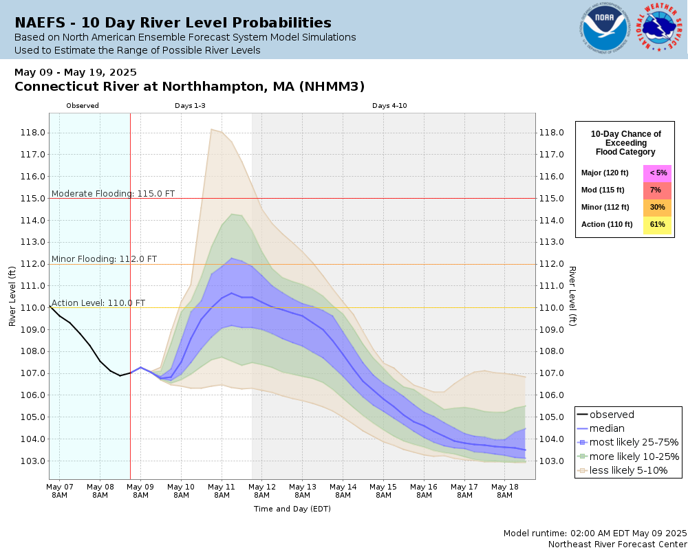
Potential River Levels Used to Estimate the Chance of Flooding and the Range of Possible River Levels |
||
| 10 Day (HEFS) | 10 Day (NAEFS) | 10 Day (GEFS) |
 |
 |
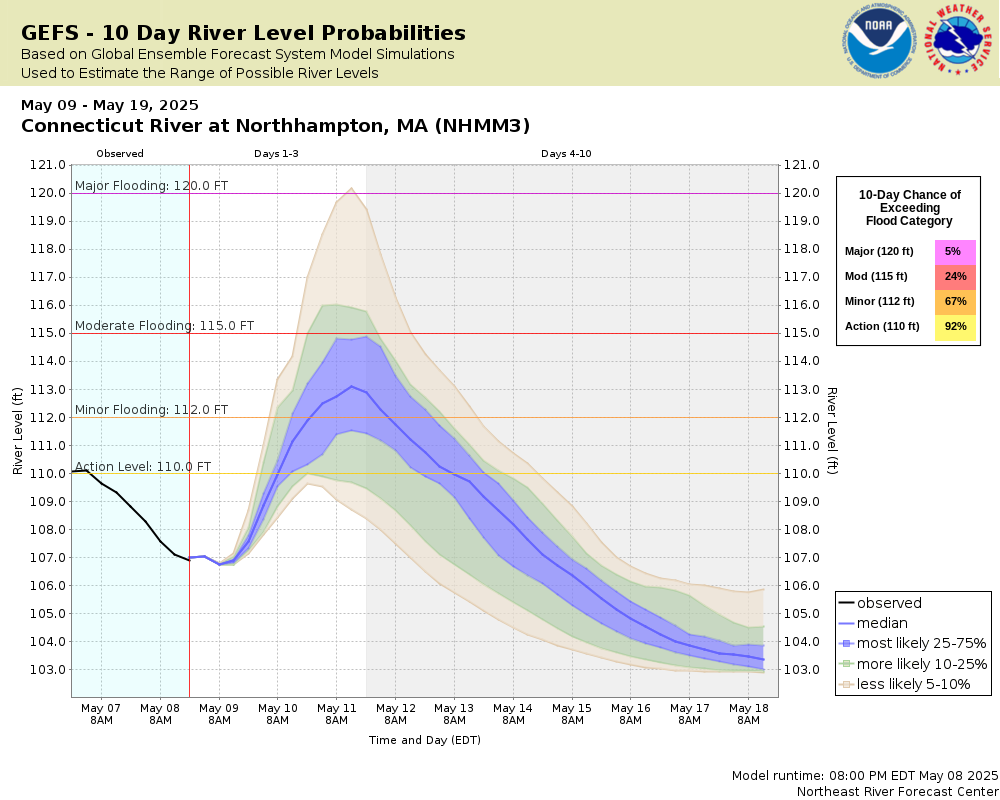 |
Note: Use the official hydrograph at the top of this web page for river levels within the next 72 hours.
Click individual graphics to enlarge.
River stage data provided by the Northampton Department of Public Works.Collaborative Agencies
The National Weather Service prepares its forecasts and other services in collaboration with agencies like the US Geological Survey, US Bureau of Reclamation, US Army Corps of Engineers, Natural Resource Conservation Service, National Park Service, ALERT Users Group, Bureau of Indian Affairs, and many state and local emergency managers across the country. For details, please click here.