White River (IN) at Anderson
Future / Actual / Minor
OWP 2.0 WWA Modal Title
01/11/2021, 10:04 PM UTC through 01/11/2021, 10:04 PM UTC
Sender
Sent
- Warning: no valid ratings curve available. Transformations to and from FEET/CFS/KCFS will not happen.
Traces and Thresholds Click to turn on/off display
Observed (OBS) 06/17/2025 2:30 AM EDTRecord: 23.6 ftLow Threshold: 0.028 kcfsCATEGORY STAGE 
Major Flooding 19 ft Moderate Flooding 15 ft Minor Flooding 10 ft Action 7.8 ft Reliability of the Forecast: Based on current and forecast river, weather and reservoir conditions
NOTE: Forecasts are issued as needed during times of high water, but are not routinely available.
National Water Model Hydrograph
Official NWS streamflow forecasts are produced by NWS hydrologic forecasters for river gauge locations using hydrologic models which are calibrated to that location. This process considers additional guidance and information, including local expertise and experience, to produce the best forecast possible. The NWM output provides supplemental guidance to NWS forecasters and should not be considered an official NWS river forecast.
Flood Impacts
- 25 - Major power station is downtown Anderson is affected above 25 feet.
- 24 - Record flood is in progress. Northeast and northwest portions of Anderson are under water. Water is several feet deep in residential, commercial, and municipal areas. SRs 109, 32, 9 and I-69 could be the only roads open over the White River. Many roads are impassable. Bridges may also be impassable or not safe for traffic.
- 23.99 - Water nearing top of levee on right bank. Evacuations of the following areas in Anderson should have occurred: Park Place, Riverside Drive, Irondale, Alexandria Pike, Hollywood Estates, Phar-Mor Plaza area, Dewey Street Plant of Anderson Water Pollution Control, Moss Island Road, Rose Street, Hazlett Steet, West 1st, 2nd, 3rd, 6th, and 7th Streets, Henry Street and Sycamore Street.
Gauge Info
| Coordinates | 40.1053, -85.6714 |
| RFC | OHRFC |
| State | IN |
| WFO | IND |
| County | Madison |
| Data Provider(s) | |
| US Geological Survey | USGS--Water Resources of the United States |
| USGS | 03348000 |
Gauge Location
Recent Crests
| 1. | 17.57 ft | on 04-06-2025 | (P) |
| 2. | 16.33 ft | on 04-12-2024 | (P) |
| 3. | 10.74 ft | on 07-18-2022 | (P) |
| 4. | 13.54 ft | on 03-08-2022 | (P) |
| 5. | 13.16 ft | on 10-26-2021 | (P) |
Recent Crests
| 1. | 17.57 ft | on 04-06-2025 | (P) |
| 2. | 16.33 ft | on 04-12-2024 | (P) |
| 3. | 10.74 ft | on 07-18-2022 | (P) |
| 4. | 13.54 ft | on 03-08-2022 | (P) |
| 5. | 13.16 ft | on 10-26-2021 | (P) |
| 6. | 11.30 ft | on 05-10-2021 | (P) |
| 7. | 10.62 ft | on 03-20-2021 | (P) |
| 8. | 14.56 ft | on 03-30-2020 | (P) |
| 9. | 11.39 ft | on 02-11-2020 | (P) |
| 10. | 13.32 ft | on 01-12-2020 | (P) |
| 11. | 10.04 ft | on 07-11-2019 | |
| 12. | 13.05 ft | on 06-17-2019 | |
| 13. | 15.54 ft | on 04-27-2019 | |
| 14. | 10.59 ft | on 03-11-2019 | |
| 15. | 13.42 ft | on 02-08-2019 | |
| 16. | 12.04 ft | on 01-01-2019 | |
| 17. | 12.78 ft | on 11-03-2018 | |
| 18. | 14.75 ft | on 09-10-2018 | |
| 19. | 16.25 ft | on 04-04-2018 | (P) |
| 20. | 12.05 ft | on 02-26-2018 | (P) |
| 21. | 12.32 ft | on 11-19-2017 | (P) |
| 22. | 11.95 ft | on 11-06-2017 | (P) |
| 23. | 13.49 ft | on 07-08-2017 | (P) |
| 24. | 11.42 ft | on 07-01-2017 | (P) |
| 25. | 13.99 ft | on 06-24-2017 | (P) |
| 26. | 12.68 ft | on 05-26-2017 | (P) |
| 27. | 13.06 ft | on 05-05-2017 | (P) |
| 28. | 7.94 ft | on 03-31-2017 | (P) |
| 29. | 10.35 ft | on 01-21-2017 | (P) |
| 30. | 12.83 ft | on 12-29-2015 | (P) |
| 31. | 15.38 ft | on 06-27-2015 | |
| 32. | 11.86 ft | on 04-04-2014 | |
| 33. | 18.82 ft | on 12-23-2013 | |
| 34. | 15.10 ft | on 01-14-2013 | |
| 35. | 10.69 ft | on 12-06-2011 | |
| 36. | 15.16 ft | on 03-06-2011 | |
| 37. | 16.56 ft | on 03-01-2011 | |
| 38. | 10.22 ft | on 06-23-2010 | |
| 39. | 11.95 ft | on 03-14-2010 | |
| 40. | 11.43 ft | on 02-12-2009 | |
| 41. | 13.29 ft | on 06-05-2008 | |
| 42. | 14.68 ft | on 02-07-2008 | |
| 43. | 13.23 ft | on 01-10-2008 | |
| 44. | 17.01 ft | on 03-24-2007 | |
| 45. | 13.18 ft | on 01-16-2007 | |
| 46. | 12.72 ft | on 12-02-2006 | |
| 47. | 15.02 ft | on 01-13-2005 | |
| 48. | 16.15 ft | on 01-07-2005 | |
| 49. | 8.21 ft | on 06-17-2004 | |
| 50. | 8.85 ft | on 06-17-2004 | |
| 51. | 9.57 ft | on 06-15-2004 | |
| 52. | 8.86 ft | on 06-14-2004 | |
| 53. | 10.76 ft | on 06-12-2004 | |
| 54. | 10.69 ft | on 06-12-2004 | |
| 55. | 13.57 ft | on 01-06-2004 | |
| 56. | 19.48 ft | on 09-03-2003 | |
| 57. | 15.79 ft | on 07-09-2003 | |
| 58. | 14.94 ft | on 05-13-2002 | |
| 59. | 13.30 ft | on 10-25-2001 | |
| 60. | 9.72 ft | on 04-12-2001 | |
| 61. | 7.80 ft | on 04-08-2000 | |
| 62. | 12.80 ft | on 01-23-1999 | |
| 63. | 11.00 ft | on 06-13-1998 | |
| 64. | 6.50 ft | on 05-08-1998 | |
| 65. | 11.80 ft | on 04-11-1998 | |
| 66. | 9.00 ft | on 03-19-1998 | |
| 67. | 6.80 ft | on 03-10-1998 | |
| 68. | 13.50 ft | on 06-02-1997 | |
| 69. | 12.00 ft | on 02-28-1997 | |
| 70. | 10.20 ft | on 12-25-1996 | |
| 71. | 10.90 ft | on 04-30-1996 | |
| 72. | 10.10 ft | on 04-24-1996 | |
| 73. | 13.00 ft | on 01-19-1996 | |
| 74. | 12.50 ft | on 05-20-1995 | |
| 75. | 10.73 ft | on 04-11-1994 | |
| 76. | 12.29 ft | on 01-29-1994 | |
| 77. | 14.00 ft | on 11-18-1993 | |
| 78. | 18.17 ft | on 11-16-1993 | |
| 79. | 11.78 ft | on 07-03-1993 | |
| 80. | 11.21 ft | on 07-02-1993 | |
| 81. | 9.30 ft | on 11-23-1992 | |
| 82. | 12.27 ft | on 11-13-1992 | |
| 83. | 9.26 ft | on 07-31-1992 | |
| 84. | 10.43 ft | on 07-25-1992 | |
| 85. | 11.03 ft | on 07-18-1992 | |
| 86. | 7.93 ft | on 07-14-1992 | |
| 87. | 10.09 ft | on 04-18-1992 | |
| 88. | 8.92 ft | on 03-23-1991 | |
| 89. | 8.91 ft | on 03-18-1991 | |
| 90. | 18.83 ft | on 12-31-1990 | |
| 91. | 8.44 ft | on 12-22-1990 | |
| 92. | 8.70 ft | on 12-19-1990 | |
| 93. | 9.13 ft | on 08-30-1990 | |
| 94. | 10.57 ft | on 06-09-1990 | |
| 95. | 9.82 ft | on 05-17-1990 | |
| 96. | 9.32 ft | on 05-14-1990 | |
| 97. | 10.21 ft | on 03-12-1990 | |
| 98. | 11.66 ft | on 02-16-1990 | |
| 99. | 10.56 ft | on 09-15-1989 | |
| 100. | 13.53 ft | on 09-02-1989 | |
| 101. | 9.41 ft | on 07-20-1989 | |
| 102. | 10.56 ft | on 05-27-1989 | |
| 103. | 11.64 ft | on 04-05-1989 | |
| 104. | 9.59 ft | on 03-31-1989 | |
| 105. | 7.63 ft | on 04-07-1988 | |
| 106. | 8.70 ft | on 07-02-1987 | |
| 107. | 12.76 ft | on 06-04-1987 | |
| 108. | 9.52 ft | on 10-05-1986 | |
| 109. | 8.19 ft | on 07-02-1986 | |
| 110. | 8.23 ft | on 06-08-1986 | |
| 111. | 8.37 ft | on 05-08-1986 | |
| 112. | 8.92 ft | on 04-21-1986 | |
| 113. | 10.31 ft | on 03-19-1986 | |
| 114. | 7.95 ft | on 03-13-1986 | |
| 115. | 14.50 ft | on 12-12-1985 | |
| 116. | 9.92 ft | on 11-28-1985 | |
| 117. | 11.01 ft | on 04-01-1985 | |
| 118. | 9.38 ft | on 03-12-1985 | |
| 119. | 16.19 ft | on 02-24-1985 | |
| 120. | 11.10 ft | on 04-23-1984 | |
| 121. | 9.26 ft | on 03-21-1984 | |
| 122. | 10.89 ft | on 03-17-1984 | |
| 123. | 9.23 ft | on 02-11-1984 | |
| 124. | 10.03 ft | on 12-12-1983 | |
| 125. | 10.02 ft | on 05-02-1983 | |
| 126. | 9.65 ft | on 03-20-1982 | |
| 127. | 9.88 ft | on 03-17-1982 | |
| 128. | 9.90 ft | on 03-12-1982 | |
| 129. | 9.25 ft | on 03-05-1982 | |
| 130. | 10.14 ft | on 02-24-1982 | |
| 131. | 13.55 ft | on 01-31-1982 | |
| 132. | 9.35 ft | on 01-04-1982 | |
| 133. | 11.28 ft | on 06-06-1981 | |
| 134. | 10.75 ft | on 05-28-1981 | |
| 135. | 14.44 ft | on 06-03-1980 | |
| 136. | 9.96 ft | on 03-22-1980 | |
| 137. | 10.83 ft | on 03-09-1980 | |
| 138. | 9.28 ft | on 02-22-1980 | |
| 139. | 9.20 ft | on 12-25-1979 | |
| 140. | 9.91 ft | on 11-29-1979 | |
| 141. | 9.69 ft | on 11-26-1979 | |
| 142. | 9.60 ft | on 11-25-1979 | |
| 143. | 11.70 ft | on 08-22-1979 | |
| 144. | 11.42 ft | on 08-02-1979 | |
| 145. | 10.53 ft | on 07-29-1979 | |
| 146. | 9.83 ft | on 07-27-1979 | |
| 147. | 11.64 ft | on 03-05-1979 | |
| 148. | 12.42 ft | on 02-24-1979 | |
| 149. | 9.83 ft | on 01-02-1979 | |
| 150. | 9.45 ft | on 04-26-1978 | |
| 151. | 9.16 ft | on 04-07-1978 | |
| 152. | 10.88 ft | on 03-22-1978 | |
| 153. | 11.95 ft | on 03-16-1978 | |
| 154. | 9.37 ft | on 12-19-1977 | |
| 155. | 11.52 ft | on 12-15-1977 | |
| 156. | 8.51 ft | on 02-27-1977 | |
| 157. | 9.70 ft | on 03-05-1976 | |
| 158. | 12.00 ft | on 02-17-1976 | |
| 159. | 10.88 ft | on 02-11-1976 | |
| 160. | 9.95 ft | on 01-26-1976 | |
| 161. | 14.55 ft | on 02-24-1975 | |
| 162. | 9.50 ft | on 02-18-1975 | |
| 163. | 10.10 ft | on 01-12-1975 | |
| 164. | 10.82 ft | on 01-19-1974 | |
| 165. | 10.22 ft | on 12-27-1973 | |
| 166. | 11.40 ft | on 06-06-1973 | |
| 167. | 9.83 ft | on 04-23-1973 | |
| 168. | 10.10 ft | on 03-12-1973 | |
| 169. | 11.29 ft | on 11-15-1972 | |
| 170. | 10.79 ft | on 11-03-1972 | |
| 171. | 9.92 ft | on 09-27-1972 | |
| 172. | 11.30 ft | on 04-23-1972 | |
| 173. | 10.18 ft | on 04-20-1972 | |
| 174. | 9.88 ft | on 12-30-1971 | |
| 175. | 11.50 ft | on 12-15-1971 | |
| 176. | 11.18 ft | on 02-22-1971 | |
| 177. | 11.52 ft | on 02-20-1971 | |
| 178. | 11.24 ft | on 02-05-1971 | |
| 179. | 11.10 ft | on 04-25-1970 | |
| 180. | 10.50 ft | on 03-05-1970 | |
| 181. | 11.70 ft | on 01-30-1970 | |
| 182. | 10.40 ft | on 08-10-1969 | |
| 183. | 10.90 ft | on 04-19-1969 | |
| 184. | 11.68 ft | on 01-31-1969 | |
| 185. | 11.18 ft | on 01-19-1969 | |
| 186. | 10.90 ft | on 12-28-1968 | |
| 187. | 12.00 ft | on 05-25-1968 | |
| 188. | 10.50 ft | on 04-05-1968 | |
| 189. | 12.50 ft | on 02-02-1968 | |
| 190. | 11.13 ft | on 01-31-1968 | |
| 191. | 10.34 ft | on 05-08-1967 | |
| 192. | 10.71 ft | on 03-29-1967 | |
| 193. | 12.20 ft | on 12-10-1966 | |
| 194. | 9.76 ft | on 02-11-1966 | |
| 195. | 11.08 ft | on 02-10-1965 | |
| 196. | 19.41 ft | on 04-21-1964 | |
| 197. | 12.30 ft | on 03-10-1964 | |
| 198. | 10.70 ft | on 03-20-1963 | |
| 199. | 17.56 ft | on 03-05-1963 | |
| 200. | 10.36 ft | on 07-16-1962 | |
| 201. | 10.31 ft | on 03-22-1962 | |
| 202. | 11.19 ft | on 02-27-1962 | |
| 203. | 13.21 ft | on 01-27-1962 | |
| 204. | 12.06 ft | on 04-26-1961 | |
| 205. | 11.44 ft | on 04-23-1961 | |
| 206. | 11.29 ft | on 03-14-1961 | |
| 207. | 10.66 ft | on 03-05-1961 | |
| 208. | 11.46 ft | on 02-11-1960 | |
| 209. | 10.57 ft | on 02-07-1960 | |
| 210. | 10.53 ft | on 01-16-1960 | |
| 211. | 11.76 ft | on 04-29-1959 | |
| 212. | 13.86 ft | on 02-11-1959 | |
| 213. | 18.86 ft | on 01-22-1959 | |
| 214. | 10.90 ft | on 08-03-1958 | |
| 215. | 10.53 ft | on 06-26-1958 | |
| 216. | 19.96 ft | on 06-14-1958 | |
| 217. | 16.37 ft | on 06-11-1958 | |
| 218. | 10.56 ft | on 12-26-1957 | |
| 219. | 12.96 ft | on 12-20-1957 | |
| 220. | 17.66 ft | on 06-29-1957 | |
| 221. | 11.80 ft | on 06-16-1957 | |
| 222. | 11.00 ft | on 05-22-1957 | |
| 223. | 10.92 ft | on 04-09-1957 | |
| 224. | 13.97 ft | on 04-05-1957 | |
| 225. | 10.51 ft | on 01-23-1957 | |
| 226. | 10.56 ft | on 05-28-1956 | |
| 227. | 12.44 ft | on 04-04-1956 | |
| 228. | 13.60 ft | on 02-26-1956 | |
| 229. | 15.40 ft | on 11-17-1955 | |
| 230. | 11.54 ft | on 01-06-1955 | |
| 231. | 9.69 ft | on 03-30-1954 | |
| 232. | 11.32 ft | on 05-23-1953 | |
| 233. | 10.43 ft | on 05-18-1953 | |
| 234. | 12.29 ft | on 03-05-1953 | |
| 235. | 13.15 ft | on 03-12-1952 | |
| 236. | 10.82 ft | on 02-04-1952 | |
| 237. | 13.85 ft | on 01-28-1952 | |
| 238. | 10.79 ft | on 04-23-1951 | |
| 239. | 10.50 ft | on 04-12-1951 | |
| 240. | 16.56 ft | on 02-22-1951 | |
| 241. | 10.76 ft | on 02-13-1951 | |
| 242. | 14.37 ft | on 12-04-1950 | |
| 243. | 11.56 ft | on 11-21-1950 | |
| 244. | 10.67 ft | on 09-23-1950 | |
| 245. | 10.97 ft | on 06-04-1950 | |
| 246. | 10.40 ft | on 04-05-1950 | |
| 247. | 12.91 ft | on 03-28-1950 | |
| 248. | 18.28 ft | on 02-15-1950 | |
| 249. | 14.16 ft | on 01-27-1950 | |
| 250. | 13.37 ft | on 01-17-1950 | |
| 251. | 13.62 ft | on 01-11-1950 | |
| 252. | 17.36 ft | on 01-05-1950 | |
| 253. | 12.63 ft | on 03-28-1949 | |
| 254. | 12.10 ft | on 02-16-1949 | |
| 255. | 11.54 ft | on 01-28-1949 | |
| 256. | 13.34 ft | on 01-19-1949 | |
| 257. | 15.98 ft | on 01-06-1949 | |
| 258. | 10.94 ft | on 12-16-1948 | |
| 259. | 14.67 ft | on 04-14-1948 | |
| 260. | 13.17 ft | on 04-07-1948 | |
| 261. | 12.73 ft | on 03-28-1948 | |
| 262. | 13.98 ft | on 03-24-1948 | |
| 263. | 10.50 ft | on 03-20-1948 | |
| 264. | 10.58 ft | on 02-15-1948 | |
| 265. | 13.39 ft | on 01-02-1948 | |
| 266. | 11.54 ft | on 06-03-1947 | |
| 267. | 10.60 ft | on 05-03-1947 | |
| 268. | 10.49 ft | on 04-26-1947 | |
| 269. | 10.72 ft | on 01-31-1947 | |
| 270. | 10.77 ft | on 12-31-1945 | |
| 271. | 10.41 ft | on 10-02-1945 | |
| 272. | 13.91 ft | on 06-19-1945 | |
| 273. | 11.25 ft | on 04-03-1945 | |
| 274. | 11.18 ft | on 04-01-1945 | |
| 275. | 11.05 ft | on 03-07-1945 | |
| 276. | 17.33 ft | on 04-12-1944 | |
| 277. | 11.65 ft | on 03-08-1944 | |
| 278. | 12.45 ft | on 08-05-1943 | |
| 279. | 18.97 ft | on 05-18-1943 | |
| 280. | 11.00 ft | on 05-12-1943 | |
| 281. | 11.10 ft | on 03-20-1943 | |
| 282. | 12.87 ft | on 03-18-1943 | |
| 283. | 11.30 ft | on 04-10-1942 | |
| 284. | 13.03 ft | on 03-17-1942 | |
| 285. | 11.30 ft | on 03-10-1942 | |
| 286. | 11.00 ft | on 02-08-1942 | |
| 287. | 8.93 ft | on 06-04-1941 | |
| 288. | 12.00 ft | on 04-21-1940 | |
| 289. | 12.00 ft | on 04-19-1940 | |
| 290. | 14.75 ft | on 04-16-1939 | |
| 291. | 11.60 ft | on 03-13-1939 | |
| 292. | 10.40 ft | on 03-01-1939 | |
| 293. | 10.50 ft | on 01-31-1939 | |
| 294. | 13.70 ft | on 06-27-1938 | |
| 295. | 13.16 ft | on 04-09-1938 | |
| 296. | 13.33 ft | on 03-31-1938 | |
| 297. | 10.30 ft | on 03-24-1938 | |
| 298. | 11.04 ft | on 03-17-1938 | |
| 299. | 10.92 ft | on 03-06-1938 | |
| 300. | 10.52 ft | on 02-12-1938 | |
| 301. | 13.20 ft | on 12-18-1937 | |
| 302. | 10.50 ft | on 08-13-1937 | |
| 303. | 10.90 ft | on 04-06-1937 | |
| 304. | 11.20 ft | on 02-09-1937 | |
| 305. | 10.40 ft | on 01-25-1937 | |
| 306. | 13.40 ft | on 01-22-1937 | |
| 307. | 18.63 ft | on 01-15-1937 | |
| 308. | 10.70 ft | on 11-04-1936 | |
| 309. | 12.20 ft | on 02-25-1936 | |
| 310. | 11.10 ft | on 05-04-1935 | |
| 311. | 9.50 ft | on 03-28-1934 | |
| 312. | 17.59 ft | on 05-14-1933 | |
| 313. | 10.90 ft | on 04-18-1933 | |
| 314. | 11.20 ft | on 03-20-1933 | |
| 315. | 11.90 ft | on 01-01-1933 | |
| 316. | 11.00 ft | on 12-25-1932 | |
| 317. | 10.10 ft | on 12-12-1932 | |
| 318. | 11.30 ft | on 01-18-1932 | |
| 319. | 8.50 ft | on 04-05-1931 | |
| 320. | 14.90 ft | on 01-14-1930 | |
| 321. | 13.80 ft | on 07-02-1929 | |
| 322. | 12.10 ft | on 03-31-1928 | |
| 323. | 10.20 ft | on 09-12-1927 | |
| 324. | 15.30 ft | on 05-20-1927 | |
| 325. | 17.50 ft | on 03-21-1927 | |
| 326. | 10.80 ft | on 09-25-1926 | |
| 327. | 10.10 ft | on 09-17-1926 | |
| 328. | 14.00 ft | on 09-10-1926 | |
| 329. | 13.30 ft | on 09-07-1926 | |
| 330. | 13.10 ft | on 04-08-1926 | |
| 331. | 10.30 ft | on 11-16-1925 | |
| 332. | 12.40 ft | on 11-14-1925 | |
| 333. | 10.80 ft | on 12-19-1924 | |
| 334. | 15.30 ft | on 03-29-1924 | |
| 335. | 12.10 ft | on 03-17-1923 | |
| 336. | 17.50 ft | on 04-15-1922 | |
| 337. | 15.00 ft | on 03-28-1921 | |
| 338. | 13.40 ft | on 04-21-1920 | |
| 339. | 14.90 ft | on 03-17-1919 | |
| 340. | 9.60 ft | on 02-13-1918 | |
| 341. | 12.40 ft | on 03-14-1917 | |
| 342. | 17.60 ft | on 01-31-1916 | |
| 343. | 11.20 ft | on 02-02-1915 | |
| 344. | 11.50 ft | on 04-08-1914 | |
| 345. | 23.60 ft | on 03-25-1913 | |
| 346. | 14.90 ft | on 03-30-1912 | |
| 347. | 10.80 ft | on 01-28-1911 | |
| 348. | 20.30 ft | on 03-23-1904 |
Historic Crests
| 1. | 23.60 ft | on 03-25-1913 |
| 2. | 20.30 ft | on 03-23-1904 |
| 3. | 19.96 ft | on 06-14-1958 |
| 4. | 19.48 ft | on 09-03-2003 |
| 5. | 19.41 ft | on 04-21-1964 |
Historic Crests
| 1. | 23.60 ft | on 03-25-1913 | |
| 2. | 20.30 ft | on 03-23-1904 | |
| 3. | 19.96 ft | on 06-14-1958 | |
| 4. | 19.48 ft | on 09-03-2003 | |
| 5. | 19.41 ft | on 04-21-1964 | |
| 6. | 18.97 ft | on 05-18-1943 | |
| 7. | 18.86 ft | on 01-22-1959 | |
| 8. | 18.83 ft | on 12-31-1990 | |
| 9. | 18.82 ft | on 12-23-2013 | |
| 10. | 18.63 ft | on 01-15-1937 | |
| 11. | 18.28 ft | on 02-15-1950 | |
| 12. | 18.17 ft | on 11-16-1993 | |
| 13. | 17.66 ft | on 06-29-1957 | |
| 14. | 17.60 ft | on 01-31-1916 | |
| 15. | 17.59 ft | on 05-14-1933 | |
| 16. | 17.57 ft | on 04-06-2025 | (P) |
| 17. | 17.56 ft | on 03-05-1963 | |
| 18. | 17.50 ft | on 03-21-1927 | |
| 19. | 17.50 ft | on 04-15-1922 | |
| 20. | 17.36 ft | on 01-05-1950 | |
| 21. | 17.33 ft | on 04-12-1944 | |
| 22. | 17.01 ft | on 03-24-2007 | |
| 23. | 16.56 ft | on 02-22-1951 | |
| 24. | 16.56 ft | on 03-01-2011 | |
| 25. | 16.37 ft | on 06-11-1958 | |
| 26. | 16.33 ft | on 04-12-2024 | (P) |
| 27. | 16.25 ft | on 04-04-2018 | (P) |
| 28. | 16.19 ft | on 02-24-1985 | |
| 29. | 16.15 ft | on 01-07-2005 | |
| 30. | 15.98 ft | on 01-06-1949 | |
| 31. | 15.79 ft | on 07-09-2003 | |
| 32. | 15.54 ft | on 04-27-2019 | |
| 33. | 15.40 ft | on 11-17-1955 | |
| 34. | 15.38 ft | on 06-27-2015 | |
| 35. | 15.30 ft | on 05-20-1927 | |
| 36. | 15.30 ft | on 03-29-1924 | |
| 37. | 15.16 ft | on 03-06-2011 | |
| 38. | 15.10 ft | on 01-14-2013 | |
| 39. | 15.02 ft | on 01-13-2005 | |
| 40. | 15.00 ft | on 03-28-1921 | |
| 41. | 14.94 ft | on 05-13-2002 | |
| 42. | 14.90 ft | on 03-17-1919 | |
| 43. | 14.90 ft | on 03-30-1912 | |
| 44. | 14.90 ft | on 01-14-1930 | |
| 45. | 14.75 ft | on 09-10-2018 | |
| 46. | 14.75 ft | on 04-16-1939 | |
| 47. | 14.68 ft | on 02-07-2008 | |
| 48. | 14.67 ft | on 04-14-1948 | |
| 49. | 14.56 ft | on 03-30-2020 | (P) |
| 50. | 14.55 ft | on 02-24-1975 | |
| 51. | 14.50 ft | on 12-12-1985 | |
| 52. | 14.44 ft | on 06-03-1980 | |
| 53. | 14.37 ft | on 12-04-1950 | |
| 54. | 14.16 ft | on 01-27-1950 | |
| 55. | 14.00 ft | on 11-18-1993 | |
| 56. | 14.00 ft | on 09-10-1926 | |
| 57. | 13.99 ft | on 06-24-2017 | (P) |
| 58. | 13.98 ft | on 03-24-1948 | |
| 59. | 13.97 ft | on 04-05-1957 | |
| 60. | 13.91 ft | on 06-19-1945 | |
| 61. | 13.86 ft | on 02-11-1959 | |
| 62. | 13.85 ft | on 01-28-1952 | |
| 63. | 13.80 ft | on 07-02-1929 | |
| 64. | 13.70 ft | on 06-27-1938 | |
| 65. | 13.62 ft | on 01-11-1950 | |
| 66. | 13.60 ft | on 02-26-1956 | |
| 67. | 13.57 ft | on 01-06-2004 | |
| 68. | 13.55 ft | on 01-31-1982 | |
| 69. | 13.54 ft | on 03-08-2022 | (P) |
| 70. | 13.53 ft | on 09-02-1989 | |
| 71. | 13.50 ft | on 06-02-1997 | |
| 72. | 13.49 ft | on 07-08-2017 | (P) |
| 73. | 13.42 ft | on 02-08-2019 | |
| 74. | 13.40 ft | on 01-22-1937 | |
| 75. | 13.40 ft | on 04-21-1920 | |
| 76. | 13.39 ft | on 01-02-1948 | |
| 77. | 13.37 ft | on 01-17-1950 | |
| 78. | 13.34 ft | on 01-19-1949 | |
| 79. | 13.33 ft | on 03-31-1938 | |
| 80. | 13.32 ft | on 01-12-2020 | (P) |
| 81. | 13.30 ft | on 10-25-2001 | |
| 82. | 13.30 ft | on 09-07-1926 | |
| 83. | 13.29 ft | on 06-05-2008 | |
| 84. | 13.23 ft | on 01-10-2008 | |
| 85. | 13.21 ft | on 01-27-1962 | |
| 86. | 13.20 ft | on 12-18-1937 | |
| 87. | 13.18 ft | on 01-16-2007 | |
| 88. | 13.17 ft | on 04-07-1948 | |
| 89. | 13.16 ft | on 04-09-1938 | |
| 90. | 13.16 ft | on 10-26-2021 | (P) |
| 91. | 13.15 ft | on 03-12-1952 | |
| 92. | 13.10 ft | on 04-08-1926 | |
| 93. | 13.06 ft | on 05-05-2017 | (P) |
| 94. | 13.05 ft | on 06-17-2019 | |
| 95. | 13.03 ft | on 03-17-1942 | |
| 96. | 13.00 ft | on 01-19-1996 | |
| 97. | 12.96 ft | on 12-20-1957 | |
| 98. | 12.91 ft | on 03-28-1950 | |
| 99. | 12.87 ft | on 03-18-1943 | |
| 100. | 12.83 ft | on 12-29-2015 | (P) |
| 101. | 12.80 ft | on 01-23-1999 | |
| 102. | 12.78 ft | on 11-03-2018 | |
| 103. | 12.76 ft | on 06-04-1987 | |
| 104. | 12.73 ft | on 03-28-1948 | |
| 105. | 12.72 ft | on 12-02-2006 | |
| 106. | 12.68 ft | on 05-26-2017 | (P) |
| 107. | 12.63 ft | on 03-28-1949 | |
| 108. | 12.50 ft | on 02-02-1968 | |
| 109. | 12.50 ft | on 05-20-1995 | |
| 110. | 12.45 ft | on 08-05-1943 | |
| 111. | 12.44 ft | on 04-04-1956 | |
| 112. | 12.42 ft | on 02-24-1979 | |
| 113. | 12.40 ft | on 03-14-1917 | |
| 114. | 12.40 ft | on 11-14-1925 | |
| 115. | 12.32 ft | on 11-19-2017 | (P) |
| 116. | 12.30 ft | on 03-10-1964 | |
| 117. | 12.29 ft | on 03-05-1953 | |
| 118. | 12.29 ft | on 01-29-1994 | |
| 119. | 12.27 ft | on 11-13-1992 | |
| 120. | 12.20 ft | on 12-10-1966 | |
| 121. | 12.20 ft | on 02-25-1936 | |
| 122. | 12.10 ft | on 03-17-1923 | |
| 123. | 12.10 ft | on 03-31-1928 | |
| 124. | 12.10 ft | on 02-16-1949 | |
| 125. | 12.06 ft | on 04-26-1961 | |
| 126. | 12.05 ft | on 02-26-2018 | (P) |
| 127. | 12.04 ft | on 01-01-2019 | |
| 128. | 12.00 ft | on 02-28-1997 | |
| 129. | 12.00 ft | on 02-17-1976 | |
| 130. | 12.00 ft | on 04-19-1940 | |
| 131. | 12.00 ft | on 04-21-1940 | |
| 132. | 12.00 ft | on 05-25-1968 | |
| 133. | 11.95 ft | on 03-16-1978 | |
| 134. | 11.95 ft | on 03-14-2010 | |
| 135. | 11.95 ft | on 11-06-2017 | (P) |
| 136. | 11.90 ft | on 01-01-1933 | |
| 137. | 11.86 ft | on 04-04-2014 | |
| 138. | 11.80 ft | on 04-11-1998 | |
| 139. | 11.80 ft | on 06-16-1957 | |
| 140. | 11.78 ft | on 07-03-1993 | |
| 141. | 11.76 ft | on 04-29-1959 | |
| 142. | 11.70 ft | on 08-22-1979 | |
| 143. | 11.70 ft | on 01-30-1970 | |
| 144. | 11.68 ft | on 01-31-1969 | |
| 145. | 11.66 ft | on 02-16-1990 | |
| 146. | 11.65 ft | on 03-08-1944 | |
| 147. | 11.64 ft | on 04-05-1989 | |
| 148. | 11.64 ft | on 03-05-1979 | |
| 149. | 11.60 ft | on 03-13-1939 | |
| 150. | 11.56 ft | on 11-21-1950 | |
| 151. | 11.54 ft | on 01-28-1949 | |
| 152. | 11.54 ft | on 01-06-1955 | |
| 153. | 11.54 ft | on 06-03-1947 | |
| 154. | 11.52 ft | on 02-20-1971 | |
| 155. | 11.52 ft | on 12-15-1977 | |
| 156. | 11.50 ft | on 04-08-1914 | |
| 157. | 11.50 ft | on 12-15-1971 | |
| 158. | 11.46 ft | on 02-11-1960 | |
| 159. | 11.44 ft | on 04-23-1961 | |
| 160. | 11.43 ft | on 02-12-2009 | |
| 161. | 11.42 ft | on 07-01-2017 | (P) |
| 162. | 11.42 ft | on 08-02-1979 | |
| 163. | 11.40 ft | on 06-06-1973 | |
| 164. | 11.39 ft | on 02-11-2020 | (P) |
| 165. | 11.32 ft | on 05-23-1953 | |
| 166. | 11.30 ft | on 05-10-2021 | (P) |
| 167. | 11.30 ft | on 01-18-1932 | |
| 168. | 11.30 ft | on 03-10-1942 | |
| 169. | 11.30 ft | on 04-10-1942 | |
| 170. | 11.30 ft | on 04-23-1972 | |
| 171. | 11.29 ft | on 03-14-1961 | |
| 172. | 11.29 ft | on 11-15-1972 | |
| 173. | 11.28 ft | on 06-06-1981 | |
| 174. | 11.25 ft | on 04-03-1945 | |
| 175. | 11.24 ft | on 02-05-1971 | |
| 176. | 11.21 ft | on 07-02-1993 | |
| 177. | 11.20 ft | on 02-09-1937 | |
| 178. | 11.20 ft | on 02-02-1915 | |
| 179. | 11.20 ft | on 03-20-1933 | |
| 180. | 11.19 ft | on 02-27-1962 | |
| 181. | 11.18 ft | on 01-19-1969 | |
| 182. | 11.18 ft | on 04-01-1945 | |
| 183. | 11.18 ft | on 02-22-1971 | |
| 184. | 11.13 ft | on 01-31-1968 | |
| 185. | 11.10 ft | on 04-23-1984 | |
| 186. | 11.10 ft | on 05-04-1935 | |
| 187. | 11.10 ft | on 04-25-1970 | |
| 188. | 11.10 ft | on 03-20-1943 | |
| 189. | 11.08 ft | on 02-10-1965 | |
| 190. | 11.05 ft | on 03-07-1945 | |
| 191. | 11.04 ft | on 03-17-1938 | |
| 192. | 11.03 ft | on 07-18-1992 | |
| 193. | 11.01 ft | on 04-01-1985 | |
| 194. | 11.00 ft | on 02-08-1942 | |
| 195. | 11.00 ft | on 12-25-1932 | |
| 196. | 11.00 ft | on 05-22-1957 | |
| 197. | 11.00 ft | on 05-12-1943 | |
| 198. | 11.00 ft | on 06-13-1998 | |
| 199. | 10.97 ft | on 06-04-1950 | |
| 200. | 10.94 ft | on 12-16-1948 | |
| 201. | 10.92 ft | on 04-09-1957 | |
| 202. | 10.92 ft | on 03-06-1938 | |
| 203. | 10.90 ft | on 04-19-1969 | |
| 204. | 10.90 ft | on 04-06-1937 | |
| 205. | 10.90 ft | on 08-03-1958 | |
| 206. | 10.90 ft | on 12-28-1968 | |
| 207. | 10.90 ft | on 04-30-1996 | |
| 208. | 10.90 ft | on 04-18-1933 | |
| 209. | 10.89 ft | on 03-17-1984 | |
| 210. | 10.88 ft | on 03-22-1978 | |
| 211. | 10.88 ft | on 02-11-1976 | |
| 212. | 10.83 ft | on 03-09-1980 | |
| 213. | 10.82 ft | on 02-04-1952 | |
| 214. | 10.82 ft | on 01-19-1974 | |
| 215. | 10.80 ft | on 12-19-1924 | |
| 216. | 10.80 ft | on 09-25-1926 | |
| 217. | 10.80 ft | on 01-28-1911 | |
| 218. | 10.79 ft | on 11-03-1972 | |
| 219. | 10.79 ft | on 04-23-1951 | |
| 220. | 10.77 ft | on 12-31-1945 | |
| 221. | 10.76 ft | on 06-12-2004 | |
| 222. | 10.76 ft | on 02-13-1951 | |
| 223. | 10.75 ft | on 05-28-1981 | |
| 224. | 10.74 ft | on 07-18-2022 | (P) |
| 225. | 10.73 ft | on 04-11-1994 | |
| 226. | 10.72 ft | on 01-31-1947 | |
| 227. | 10.71 ft | on 03-29-1967 | |
| 228. | 10.70 ft | on 11-04-1936 | |
| 229. | 10.70 ft | on 03-20-1963 | |
| 230. | 10.69 ft | on 06-12-2004 | |
| 231. | 10.69 ft | on 12-06-2011 | |
| 232. | 10.67 ft | on 09-23-1950 | |
| 233. | 10.66 ft | on 03-05-1961 | |
| 234. | 10.62 ft | on 03-20-2021 | (P) |
| 235. | 10.60 ft | on 05-03-1947 | |
| 236. | 10.59 ft | on 03-11-2019 | |
| 237. | 10.58 ft | on 02-15-1948 | |
| 238. | 10.57 ft | on 06-09-1990 | |
| 239. | 10.57 ft | on 02-07-1960 | |
| 240. | 10.56 ft | on 09-15-1989 | |
| 241. | 10.56 ft | on 05-27-1989 | |
| 242. | 10.56 ft | on 12-26-1957 | |
| 243. | 10.56 ft | on 05-28-1956 | |
| 244. | 10.53 ft | on 01-16-1960 | |
| 245. | 10.53 ft | on 06-26-1958 | |
| 246. | 10.53 ft | on 07-29-1979 | |
| 247. | 10.52 ft | on 02-12-1938 | |
| 248. | 10.51 ft | on 01-23-1957 | |
| 249. | 10.50 ft | on 04-05-1968 | |
| 250. | 10.50 ft | on 03-05-1970 | |
| 251. | 10.50 ft | on 04-12-1951 | |
| 252. | 10.50 ft | on 03-20-1948 | |
| 253. | 10.50 ft | on 01-31-1939 | |
| 254. | 10.50 ft | on 08-13-1937 | |
| 255. | 10.49 ft | on 04-26-1947 | |
| 256. | 10.43 ft | on 05-18-1953 | |
| 257. | 10.43 ft | on 07-25-1992 | |
| 258. | 10.41 ft | on 10-02-1945 | |
| 259. | 10.40 ft | on 04-05-1950 | |
| 260. | 10.40 ft | on 01-25-1937 | |
| 261. | 10.40 ft | on 03-01-1939 | |
| 262. | 10.40 ft | on 08-10-1969 | |
| 263. | 10.36 ft | on 07-16-1962 | |
| 264. | 10.35 ft | on 01-21-2017 | (P) |
| 265. | 10.34 ft | on 05-08-1967 | |
| 266. | 10.31 ft | on 03-19-1986 | |
| 267. | 10.31 ft | on 03-22-1962 | |
| 268. | 10.30 ft | on 11-16-1925 | |
| 269. | 10.30 ft | on 03-24-1938 | |
| 270. | 10.22 ft | on 06-23-2010 | |
| 271. | 10.22 ft | on 12-27-1973 | |
| 272. | 10.21 ft | on 03-12-1990 | |
| 273. | 10.20 ft | on 09-12-1927 | |
| 274. | 10.20 ft | on 12-25-1996 | |
| 275. | 10.18 ft | on 04-20-1972 | |
| 276. | 10.14 ft | on 02-24-1982 | |
| 277. | 10.10 ft | on 04-24-1996 | |
| 278. | 10.10 ft | on 12-12-1932 | |
| 279. | 10.10 ft | on 01-12-1975 | |
| 280. | 10.10 ft | on 03-12-1973 | |
| 281. | 10.10 ft | on 09-17-1926 | |
| 282. | 10.09 ft | on 04-18-1992 | |
| 283. | 10.04 ft | on 07-11-2019 | |
| 284. | 10.03 ft | on 12-12-1983 | |
| 285. | 10.02 ft | on 05-02-1983 | |
| 286. | 9.96 ft | on 03-22-1980 | |
| 287. | 9.95 ft | on 01-26-1976 | |
| 288. | 9.92 ft | on 09-27-1972 | |
| 289. | 9.92 ft | on 11-28-1985 | |
| 290. | 9.91 ft | on 11-29-1979 | |
| 291. | 9.90 ft | on 03-12-1982 | |
| 292. | 9.88 ft | on 12-30-1971 | |
| 293. | 9.88 ft | on 03-17-1982 | |
| 294. | 9.83 ft | on 04-23-1973 | |
| 295. | 9.83 ft | on 01-02-1979 | |
| 296. | 9.83 ft | on 07-27-1979 | |
| 297. | 9.82 ft | on 05-17-1990 | |
| 298. | 9.76 ft | on 02-11-1966 | |
| 299. | 9.72 ft | on 04-12-2001 | |
| 300. | 9.70 ft | on 03-05-1976 | |
| 301. | 9.69 ft | on 03-30-1954 | |
| 302. | 9.69 ft | on 11-26-1979 | |
| 303. | 9.65 ft | on 03-20-1982 | |
| 304. | 9.60 ft | on 02-13-1918 | |
| 305. | 9.60 ft | on 11-25-1979 | |
| 306. | 9.59 ft | on 03-31-1989 | |
| 307. | 9.57 ft | on 06-15-2004 | |
| 308. | 9.52 ft | on 10-05-1986 | |
| 309. | 9.50 ft | on 02-18-1975 | |
| 310. | 9.50 ft | on 03-28-1934 | |
| 311. | 9.45 ft | on 04-26-1978 | |
| 312. | 9.41 ft | on 07-20-1989 | |
| 313. | 9.38 ft | on 03-12-1985 | |
| 314. | 9.37 ft | on 12-19-1977 | |
| 315. | 9.35 ft | on 01-04-1982 | |
| 316. | 9.32 ft | on 05-14-1990 | |
| 317. | 9.30 ft | on 11-23-1992 | |
| 318. | 9.28 ft | on 02-22-1980 | |
| 319. | 9.26 ft | on 03-21-1984 | |
| 320. | 9.26 ft | on 07-31-1992 | |
| 321. | 9.25 ft | on 03-05-1982 | |
| 322. | 9.23 ft | on 02-11-1984 | |
| 323. | 9.20 ft | on 12-25-1979 | |
| 324. | 9.16 ft | on 04-07-1978 | |
| 325. | 9.13 ft | on 08-30-1990 | |
| 326. | 9.00 ft | on 03-19-1998 | |
| 327. | 8.93 ft | on 06-04-1941 | |
| 328. | 8.92 ft | on 03-23-1991 | |
| 329. | 8.92 ft | on 04-21-1986 | |
| 330. | 8.91 ft | on 03-18-1991 | |
| 331. | 8.86 ft | on 06-14-2004 | |
| 332. | 8.85 ft | on 06-17-2004 | |
| 333. | 8.70 ft | on 12-19-1990 | |
| 334. | 8.70 ft | on 07-02-1987 | |
| 335. | 8.51 ft | on 02-27-1977 | |
| 336. | 8.50 ft | on 04-05-1931 | |
| 337. | 8.44 ft | on 12-22-1990 | |
| 338. | 8.37 ft | on 05-08-1986 | |
| 339. | 8.23 ft | on 06-08-1986 | |
| 340. | 8.21 ft | on 06-17-2004 | |
| 341. | 8.19 ft | on 07-02-1986 | |
| 342. | 7.95 ft | on 03-13-1986 | |
| 343. | 7.94 ft | on 03-31-2017 | (P) |
| 344. | 7.93 ft | on 07-14-1992 | |
| 345. | 7.80 ft | on 04-08-2000 | |
| 346. | 7.63 ft | on 04-07-1988 | |
| 347. | 6.80 ft | on 03-10-1998 | |
| 348. | 6.50 ft | on 05-08-1998 |
Vertical Datum Table
| type | NAVD88 |
|---|---|
| major Flooding | 843.53 ft |
| moderate Flooding | 839.53 ft |
| minor Flooding | 834.53 ft |
| action | 832.33 ft |
| Latest Value | 829.80 ft |
| Gauge Zero | 824.53 ft |


Unique Local Info
|
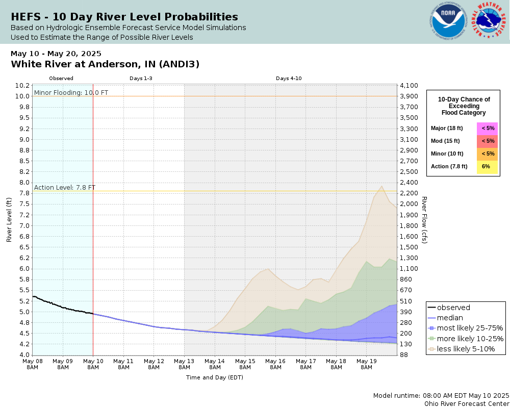
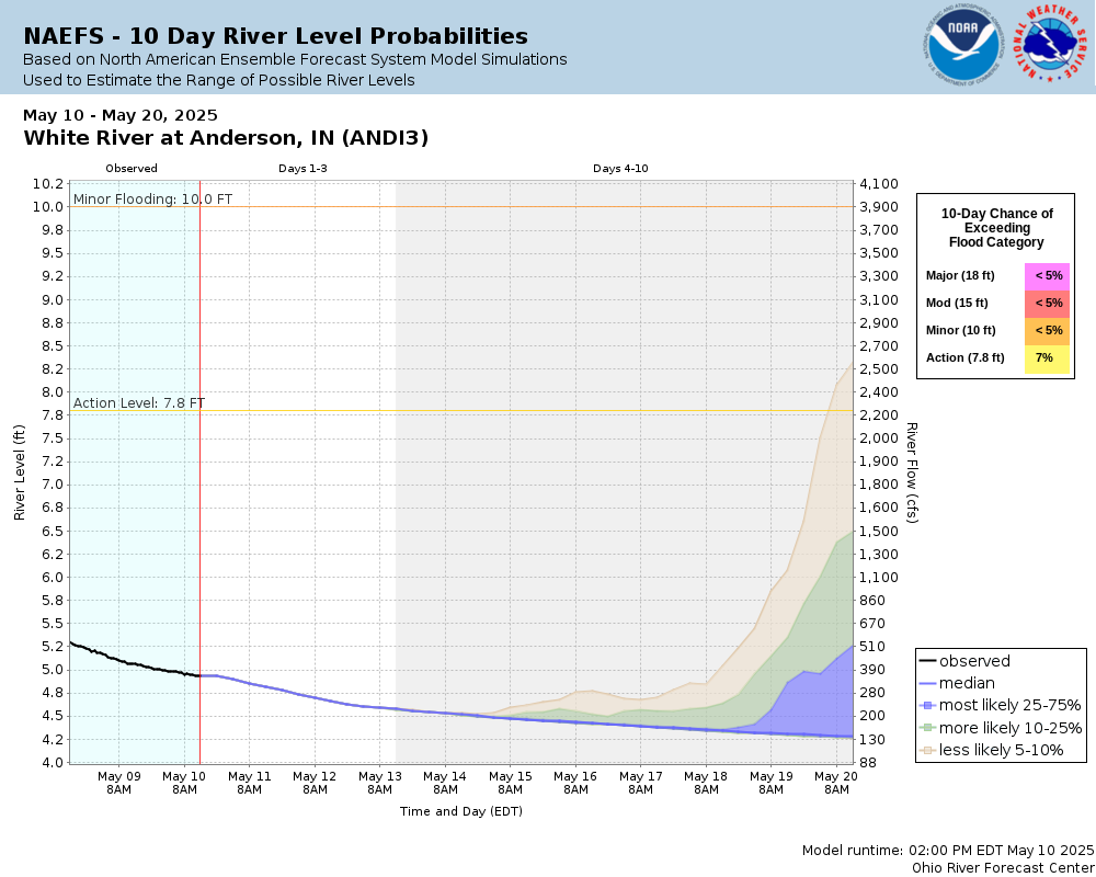
Potential River Levels Used to Estimate the Chance of Flooding and the Range of Possible River Levels |
||
| 10 Day (HEFS) | 10 Day (NAEFS) | 10 Day (GEFS) |
 |
 |
 |
Note: Use the official hydrograph at the top of this web page for river levels within the next 72 hours.
Click individual graphics to enlarge.
Total Precipitation at AndersonCollaborative Agencies
The National Weather Service prepares its forecasts and other services in collaboration with agencies like the US Geological Survey, US Bureau of Reclamation, US Army Corps of Engineers, Natural Resource Conservation Service, National Park Service, ALERT Users Group, Bureau of Indian Affairs, and many state and local emergency managers across the country. For details, please click here.
Resources
Hydrologic Resource Links
- River Forecast Centers
- Text Products
- Forecast Precipitation
- US Geological Survey Surface Water
- How to Use US Geological Survey Water Alert Feature
- Water Resources Outlook
- Wabash River Conservation Area
- Water flow from Norway and Oakdale Dams
- Indianapolis Reservoir Levels
- Midwest Region U.S. Drought Monitor
- Indianapolis Museum of Art: FLOW Can You See the River?
- The Flood of 1913 - Remembered
- Friends of the White River
Additional Resource Links
- NWS Precipitation and River Forecasting
- Area Hydrographs
- Zoomable RFC Hourly Precipitation Maps
- Zoomable Snowfall Maps
- Indiana State Climate Office
- Community Collaborative Rain, Hail & Snow Network in Indiana
- Snow Information
- Midwestern Regional Climate Center
- Indiana Precipitation Frequencies
- Drainage Areas of Indiana Streams
- Ensemble River Forecasts
- Ohio River Forecast Center