Mill Creek at Antioch
Future / Actual / Minor
OWP 2.0 WWA Modal Title
01/11/2021, 10:04 PM UTC through 01/11/2021, 10:04 PM UTC
Sender
Sent
- Warning: no valid ratings curve available. Transformations to and from FEET/CFS/KCFS will not happen.
Traces and Thresholds Click to turn on/off display
Observed (OBS) 06/21/2025 6:00 PM CDTOfficial Forecast (FCST) 06/21/2025 9:59 AM CDTRecord: 26.1 ftCATEGORY STAGE 
Major Flooding 20 ft Moderate Flooding 17 ft Minor Flooding 14 ft Action 12 ft Reliability of the Forecast: Based on current and forecast river, weather and reservoir conditions
NOTE: Forecasts are issued as needed during times of high water, but are not routinely available.
The above river forecast includes future rainfall. Forecast stages may be different if the rainfall does not occur.
National Water Model Hydrograph
Official NWS streamflow forecasts are produced by NWS hydrologic forecasters for river gauge locations using hydrologic models which are calibrated to that location. This process considers additional guidance and information, including local expertise and experience, to produce the best forecast possible. The NWM output provides supplemental guidance to NWS forecasters and should not be considered an official NWS river forecast.
Flood Impacts
- 24 - Many roads and properties in and near industrial, commercial, and residential areas along the creek are flooded, including locations near Harding Place and Harding Industrial Drive, Franklin Limestone Road, portions of Antioch Pike from near Haywood Lane to near Blue Hole Road including Antioch Middle School, Cummings Park Drive, and Waikiki Blvd.
- 22 - Flooding along Mill Creek is impacting many idustrial, commercial, and residential areas. Locations near Harding Place and Harding Industrial Drive, Franklin Limestone Road, Antioch Pike and Haywood Lane, Cummings Park Drive, and Waikiki Blvd are hardest hit. Area roads are also flooded, including Franklin Limestone Road, portions of Antioch Pike between Blue Hole Road and Reeves Road and the bridge between Haywood Lane and Richards Road, and Mc Gavock Pike north of Harding Place.
- 20 - Many roads near mill creek are flooded, including franklin limestone road, portions of antioch pike between blue hole road and reeves road and the bridge between haywood lane and richards road, and mc gavock pike north of harding place. Flooding of industrial, commercial, and residential property is occurring, especially near harding place and harding industrial drive, franklin limestone road, antioch pike and haywood lane, cummings park drive, and waikiki blvd.
Gauge Location
Recent Crests
| 1. | 13.44 ft | on 04-22-2017 |
| 2. | 11.17 ft | on 12-25-2015 |
| 3. | 11.43 ft | on 03-04-2015 |
| 4. | 11.95 ft | on 02-05-2014 |
| 5. | 15.30 ft | on 04-28-2013 |
Recent Crests
| 1. | 13.44 ft | on 04-22-2017 |
| 2. | 11.17 ft | on 12-25-2015 |
| 3. | 11.43 ft | on 03-04-2015 |
| 4. | 11.95 ft | on 02-05-2014 |
| 5. | 15.30 ft | on 04-28-2013 |
| 6. | 9.80 ft | on 01-11-2012 |
| 7. | 11.81 ft | on 04-24-2011 |
| 8. | 26.10 ft | on 05-01-2010 |
| 9. | 11.36 ft | on 09-26-2009 |
| 10. | 11.41 ft | on 04-04-2008 |
| 11. | 13.27 ft | on 01-23-2006 |
| 12. | 14.70 ft | on 10-19-2004 |
| 13. | 16.71 ft | on 02-05-2004 |
| 14. | 17.83 ft | on 05-05-2003 |
| 15. | 12.91 ft | on 01-24-2002 |
| 16. | 13.20 ft | on 02-16-2001 |
| 17. | 17.23 ft | on 05-25-2000 |
| 18. | 16.98 ft | on 01-23-1999 |
| 19. | 17.20 ft | on 06-04-1998 |
| 20. | 15.80 ft | on 03-03-1997 |
| 21. | 15.31 ft | on 10-05-1995 |
| 22. | 14.35 ft | on 05-14-1995 |
| 23. | 13.57 ft | on 03-09-1994 |
| 24. | 9.35 ft | on 03-23-1993 |
| 25. | 15.69 ft | on 12-03-1991 |
| 26. | 12.31 ft | on 12-22-1990 |
| 27. | 14.34 ft | on 02-14-1989 |
| 28. | 14.31 ft | on 12-25-1987 |
| 29. | 14.13 ft | on 11-26-1986 |
| 30. | 12.26 ft | on 09-04-1986 |
| 31. | 11.31 ft | on 11-27-1984 |
| 32. | 16.92 ft | on 05-07-1984 |
| 33. | 14.55 ft | on 05-19-1983 |
| 34. | 12.15 ft | on 02-09-1982 |
| 35. | 14.63 ft | on 03-28-1980 |
| 36. | 23.78 ft | on 05-04-1979 |
| 37. | 13.39 ft | on 03-13-1978 |
| 38. | 13.44 ft | on 03-12-1977 |
| 39. | 11.76 ft | on 03-20-1976 |
| 40. | 16.52 ft | on 03-12-1975 |
| 41. | 16.83 ft | on 11-27-1973 |
| 42. | 14.94 ft | on 12-10-1972 |
| 43. | 10.86 ft | on 08-09-1972 |
| 44. | 11.60 ft | on 01-04-1971 |
| 45. | 16.15 ft | on 06-21-1970 |
| 46. | 11.06 ft | on 04-18-1969 |
| 47. | 11.02 ft | on 03-12-1968 |
| 48. | 14.36 ft | on 03-06-1967 |
| 49. | 10.52 ft | on 10-01-1965 |
| 50. | 14.65 ft | on 03-26-1965 |
| 51. | 14.80 ft | on 03-11-1963 |
| 52. | 18.38 ft | on 02-27-1962 |
| 53. | 11.60 ft | on 04-12-1961 |
| 54. | 19.15 ft | on 06-17-1960 |
| 55. | 9.83 ft | on 07-01-1959 |
| 56. | 12.97 ft | on 12-20-1957 |
| 57. | 13.42 ft | on 01-29-1957 |
| 58. | 14.87 ft | on 02-17-1956 |
| 59. | 19.73 ft | on 03-21-1955 |
| 60. | 14.54 ft | on 03-24-1954 |
Historic Crests
| 1. | 26.10 ft | on 05-01-2010 |
| 2. | 23.78 ft | on 05-04-1979 |
| 3. | 19.73 ft | on 03-21-1955 |
| 4. | 19.15 ft | on 06-17-1960 |
| 5. | 18.38 ft | on 02-27-1962 |
Historic Crests
| 1. | 26.10 ft | on 05-01-2010 |
| 2. | 23.78 ft | on 05-04-1979 |
| 3. | 19.73 ft | on 03-21-1955 |
| 4. | 19.15 ft | on 06-17-1960 |
| 5. | 18.38 ft | on 02-27-1962 |
| 6. | 17.83 ft | on 05-05-2003 |
| 7. | 17.23 ft | on 05-25-2000 |
| 8. | 17.20 ft | on 06-04-1998 |
| 9. | 16.98 ft | on 01-23-1999 |
| 10. | 16.92 ft | on 05-07-1984 |
| 11. | 16.83 ft | on 11-27-1973 |
| 12. | 16.71 ft | on 02-05-2004 |
| 13. | 16.52 ft | on 03-12-1975 |
| 14. | 16.15 ft | on 06-21-1970 |
| 15. | 15.80 ft | on 03-03-1997 |
| 16. | 15.69 ft | on 12-03-1991 |
| 17. | 15.31 ft | on 10-05-1995 |
| 18. | 15.30 ft | on 04-28-2013 |
| 19. | 14.94 ft | on 12-10-1972 |
| 20. | 14.87 ft | on 02-17-1956 |
| 21. | 14.80 ft | on 03-11-1963 |
| 22. | 14.70 ft | on 10-19-2004 |
| 23. | 14.65 ft | on 03-26-1965 |
| 24. | 14.63 ft | on 03-28-1980 |
| 25. | 14.55 ft | on 05-19-1983 |
| 26. | 14.54 ft | on 03-24-1954 |
| 27. | 14.36 ft | on 03-06-1967 |
| 28. | 14.35 ft | on 05-14-1995 |
| 29. | 14.34 ft | on 02-14-1989 |
| 30. | 14.31 ft | on 12-25-1987 |
| 31. | 14.13 ft | on 11-26-1986 |
| 32. | 13.57 ft | on 03-09-1994 |
| 33. | 13.44 ft | on 04-22-2017 |
| 34. | 13.44 ft | on 03-12-1977 |
| 35. | 13.42 ft | on 01-29-1957 |
| 36. | 13.39 ft | on 03-13-1978 |
| 37. | 13.27 ft | on 01-23-2006 |
| 38. | 13.20 ft | on 02-16-2001 |
| 39. | 12.97 ft | on 12-20-1957 |
| 40. | 12.91 ft | on 01-24-2002 |
| 41. | 12.31 ft | on 12-22-1990 |
| 42. | 12.26 ft | on 09-04-1986 |
| 43. | 12.15 ft | on 02-09-1982 |
| 44. | 11.95 ft | on 02-05-2014 |
| 45. | 11.81 ft | on 04-24-2011 |
| 46. | 11.76 ft | on 03-20-1976 |
| 47. | 11.60 ft | on 01-04-1971 |
| 48. | 11.60 ft | on 04-12-1961 |
| 49. | 11.43 ft | on 03-04-2015 |
| 50. | 11.41 ft | on 04-04-2008 |
| 51. | 11.36 ft | on 09-26-2009 |
| 52. | 11.31 ft | on 11-27-1984 |
| 53. | 11.17 ft | on 12-25-2015 |
| 54. | 11.06 ft | on 04-18-1969 |
| 55. | 11.02 ft | on 03-12-1968 |
| 56. | 10.86 ft | on 08-09-1972 |
| 57. | 10.52 ft | on 10-01-1965 |
| 58. | 9.83 ft | on 07-01-1959 |
| 59. | 9.80 ft | on 01-11-2012 |
| 60. | 9.35 ft | on 03-23-1993 |
Vertical Datum Table
| type | NAVD88 |
|---|---|
| major Flooding | 492.61 ft |
| moderate Flooding | 489.61 ft |
| minor Flooding | 486.61 ft |
| action | 484.61 ft |
| Latest Value | 475.89 ft |
| Gauge Zero | 472.61 ft |
Gauge Photos
No Images Found


Unique Local Info
|
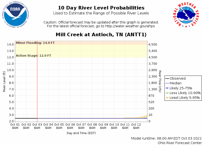
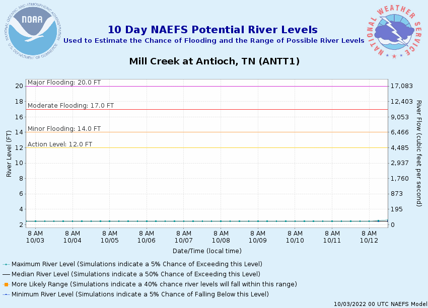
Potential River Levels Used to Estimate the Chance of Flooding and the Range of Possible River Levels |
||
| 10 Day (HEFS) | 7 Day (NAEFS) | 7 Day (GEFS) |
 |
 |
 |
Note: Use the official hydrograph at the top of this web page for river levels within the next 72 hours.
Click individual graphics to enlarge.
Collaborative Agencies
The National Weather Service prepares its forecasts and other services in collaboration with agencies like the US Geological Survey, US Bureau of Reclamation, US Army Corps of Engineers, Natural Resource Conservation Service, National Park Service, ALERT Users Group, Bureau of Indian Affairs, and many state and local emergency managers across the country. For details, please click here.