Solomon River at Beloit
Future / Actual / Minor
OWP 2.0 WWA Modal Title
01/11/2021, 10:04 PM UTC through 01/11/2021, 10:04 PM UTC
Sender
Sent
- Warning: no valid ratings curve available. Transformations to and from FEET/CFS/KCFS will not happen.
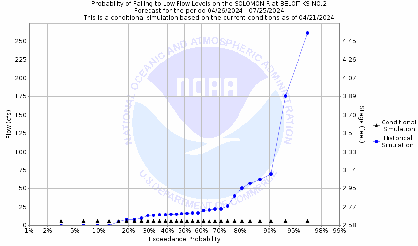
Traces and Thresholds Click to turn on/off display
Observed (OBS) 06/14/2025 1:45 AM CDTRecord: 39.3 ftCATEGORY STAGE 
Major Flooding 30 ft Moderate Flooding 25 ft Minor Flooding 20 ft Action 18 ft Reliability of the Forecast:
NOTE: Forecasts are issued as needed during times of high water, but are not routinely available.
River forecasts for this location take into account past precipitation and the precipitation amounts expected approximately 24 hours into the future from the forecast issuance time.
National Water Model Hydrograph
Official NWS streamflow forecasts are produced by NWS hydrologic forecasters for river gauge locations using hydrologic models which are calibrated to that location. This process considers additional guidance and information, including local expertise and experience, to produce the best forecast possible. The NWM output provides supplemental guidance to NWS forecasters and should not be considered an official NWS river forecast.
Flood Impacts
- 30 - A bridge on Henry Trail two miles west of town is flooded. When the water reaches a level of 36 feet flooding occurs on the south and southwest sides of Beloit.
- 25 - The bridge on Hyde Lane which is two miles southeast of Beloit is closed.
- 20 - Flooding occurs in the Beloit city park and fairgrounds. Rural lowlands outside of Beloit flood at 18 feet.
Gauge Location
Recent Crests
| 1. | 4.66 ft | on 08-26-2023 |
| 2. | 9.49 ft | on 05-26-2022 |
| 3. | 16.85 ft | on 05-28-2021 |
| 4. | 22.40 ft | on 06-27-2020 |
| 5. | 21.48 ft | on 06-23-2019 |
Recent Crests
| 1. | 4.66 ft | on 08-26-2023 |
| 2. | 9.49 ft | on 05-26-2022 |
| 3. | 16.85 ft | on 05-28-2021 |
| 4. | 22.40 ft | on 06-27-2020 |
| 5. | 21.48 ft | on 06-23-2019 |
| 6. | 22.21 ft | on 10-10-2018 |
| 7. | 4.77 ft | on 08-16-2017 |
| 8. | 3.66 ft | on 04-17-2016 |
| 9. | 12.21 ft | on 08-05-2015 |
| 10. | 14.55 ft | on 08-31-2014 |
| 11. | 15.44 ft | on 06-17-2013 |
| 12. | 23.80 ft | on 06-28-1965 |
| 13. | 18.10 ft | on 09-06-1964 |
| 14. | 22.43 ft | on 09-25-1963 |
| 15. | 24.84 ft | on 06-05-1962 |
| 16. | 36.83 ft | on 05-24-1961 |
| 17. | 32.24 ft | on 03-28-1960 |
| 18. | 20.40 ft | on 05-30-1959 |
| 19. | 24.09 ft | on 05-19-1958 |
| 20. | 34.29 ft | on 06-19-1957 |
| 21. | 18.91 ft | on 06-24-1956 |
| 22. | 22.95 ft | on 06-20-1955 |
| 23. | 20.10 ft | on 06-17-1954 |
| 24. | 14.03 ft | on 07-23-1953 |
| 25. | 17.52 ft | on 07-16-1952 |
| 26. | 39.30 ft | on 07-13-1951 |
| 27. | 33.33 ft | on 08-15-1950 |
| 28. | 28.09 ft | on 06-16-1949 |
| 29. | 25.18 ft | on 07-21-1948 |
| 30. | 26.50 ft | on 03-09-1947 |
| 31. | 29.35 ft | on 09-08-1946 |
| 32. | 27.83 ft | on 07-19-1945 |
| 33. | 29.06 ft | on 05-04-1944 |
| 34. | 27.83 ft | on 06-18-1943 |
| 35. | 35.87 ft | on 06-11-1941 |
| 36. | 17.30 ft | on 05-09-1940 |
| 37. | 27.65 ft | on 08-16-1939 |
| 38. | 21.53 ft | on 05-27-1938 |
| 39. | 20.97 ft | on 06-06-1937 |
| 40. | 22.15 ft | on 05-22-1936 |
| 41. | 34.50 ft | on 06-02-1935 |
| 42. | 24.50 ft | on 06-19-1934 |
| 43. | 18.50 ft | on 04-23-1933 |
| 44. | 18.48 ft | on 09-13-1932 |
| 45. | 20.36 ft | on 05-06-1931 |
| 46. | 15.65 ft | on 09-11-1930 |
| 47. | 26.40 ft | on 06-08-1929 |
| 48. | 28.80 ft | on 08-02-1928 |
| 49. | 29.00 ft | on 04-16-1927 |
| 50. | 27.40 ft | on 09-17-1926 |
| 51. | 28.80 ft | on 05-25-1923 |
| 52. | 33.60 ft | on 09-20-1919 |
| 53. | 26.80 ft | on 06-03-1918 |
Historic Crests
| 1. | 39.30 ft | on 07-13-1951 |
| 2. | 36.83 ft | on 05-24-1961 |
| 3. | 35.87 ft | on 06-11-1941 |
| 4. | 34.50 ft | on 06-02-1935 |
| 5. | 34.29 ft | on 06-19-1957 |
Historic Crests
| 1. | 39.30 ft | on 07-13-1951 |
| 2. | 36.83 ft | on 05-24-1961 |
| 3. | 35.87 ft | on 06-11-1941 |
| 4. | 34.50 ft | on 06-02-1935 |
| 5. | 34.29 ft | on 06-19-1957 |
| 6. | 33.60 ft | on 09-20-1919 |
| 7. | 33.33 ft | on 08-15-1950 |
| 8. | 32.24 ft | on 03-28-1960 |
| 9. | 29.35 ft | on 09-08-1946 |
| 10. | 29.06 ft | on 05-04-1944 |
| 11. | 29.00 ft | on 04-16-1927 |
| 12. | 28.80 ft | on 05-25-1923 |
| 13. | 28.80 ft | on 08-02-1928 |
| 14. | 28.09 ft | on 06-16-1949 |
| 15. | 27.83 ft | on 06-18-1943 |
| 16. | 27.83 ft | on 07-19-1945 |
| 17. | 27.65 ft | on 08-16-1939 |
| 18. | 27.40 ft | on 09-17-1926 |
| 19. | 26.80 ft | on 06-03-1918 |
| 20. | 26.50 ft | on 03-09-1947 |
| 21. | 26.40 ft | on 06-08-1929 |
| 22. | 25.18 ft | on 07-21-1948 |
| 23. | 24.84 ft | on 06-05-1962 |
| 24. | 24.50 ft | on 06-19-1934 |
| 25. | 24.09 ft | on 05-19-1958 |
| 26. | 23.80 ft | on 06-28-1965 |
| 27. | 22.95 ft | on 06-20-1955 |
| 28. | 22.43 ft | on 09-25-1963 |
| 29. | 22.40 ft | on 06-27-2020 |
| 30. | 22.21 ft | on 10-10-2018 |
| 31. | 22.15 ft | on 05-22-1936 |
| 32. | 21.53 ft | on 05-27-1938 |
| 33. | 21.48 ft | on 06-23-2019 |
| 34. | 20.97 ft | on 06-06-1937 |
| 35. | 20.40 ft | on 05-30-1959 |
| 36. | 20.36 ft | on 05-06-1931 |
| 37. | 20.10 ft | on 06-17-1954 |
| 38. | 18.91 ft | on 06-24-1956 |
| 39. | 18.50 ft | on 04-23-1933 |
| 40. | 18.48 ft | on 09-13-1932 |
| 41. | 18.10 ft | on 09-06-1964 |
| 42. | 17.52 ft | on 07-16-1952 |
| 43. | 17.30 ft | on 05-09-1940 |
| 44. | 16.85 ft | on 05-28-2021 |
| 45. | 15.65 ft | on 09-11-1930 |
| 46. | 15.44 ft | on 06-17-2013 |
| 47. | 14.55 ft | on 08-31-2014 |
| 48. | 14.03 ft | on 07-23-1953 |
| 49. | 12.21 ft | on 08-05-2015 |
| 50. | 9.49 ft | on 05-26-2022 |
| 51. | 4.77 ft | on 08-16-2017 |
| 52. | 4.66 ft | on 08-26-2023 |
| 53. | 3.66 ft | on 04-17-2016 |


Unique Local Info
Collaborative Agencies
The National Weather Service prepares its forecasts and other services in collaboration with agencies like the US Geological Survey, US Bureau of Reclamation, US Army Corps of Engineers, Natural Resource Conservation Service, National Park Service, ALERT Users Group, Bureau of Indian Affairs, and many state and local emergency managers across the country. For details, please click here.