Maury River near Buena Vista
Future / Actual / Minor
OWP 2.0 WWA Modal Title
01/11/2021, 10:04 PM UTC through 01/11/2021, 10:04 PM UTC
Sender
Sent
- Downstream gauge unavailableWarning: no valid ratings curve available. Transformations to and from FEET/CFS/KCFS will not happen.
Traces and Thresholds Click to turn on/off display
Observed (OBS) 06/14/2025 8:25 PM EDTOfficial Forecast (FCST) 06/14/2025 9:49 AM EDTRecord: 31.2 ftCATEGORY STAGE 
Major Flooding 21 ft Moderate Flooding 19 ft Minor Flooding 17 ft Action 13 ft Reliability of the Forecast:
NOTE: Forecasts are issued routinely year-round.
River forecasts for this location take into account past precipitation and the precipitation amounts expected approximately 72 hours into the future from the forecast issuance time.
National Water Model Hydrograph
Official NWS streamflow forecasts are produced by NWS hydrologic forecasters for river gauge locations using hydrologic models which are calibrated to that location. This process considers additional guidance and information, including local expertise and experience, to produce the best forecast possible. The NWM output provides supplemental guidance to NWS forecasters and should not be considered an official NWS river forecast.
Flood Impacts
- 29 - Buena Vista municipal buildings and downtown areas inundated.
- 21 - Water overflows railroad bed, allowing for extensive flooding.
- 19 - Evacuation of campers/recreational interests in city park.
- 17 - Some areas of city (along left bank) experience overflow.
- 13 - One industry (bonded fibers) begins moving equipment.
Gauge Info
| Coordinates | 37.7625, -79.3917 |
| RFC | MARFC |
| State | VA |
| WFO | RNK |
| County | Rockbridge |
| Data Provider(s) | |
| US Geological Survey | USGS--Water Resources of the United States |
| USGS | 02024000 |
Gauge Location
Recent Crests
| 1. | 8.86 ft | on 04-12-2024 |
| 2. | 8.67 ft | on 01-29-2024 |
| 3. | 8.80 ft | on 02-18-2023 |
| 4. | 8.89 ft | on 02-04-2022 |
| 5. | 9.58 ft | on 09-23-2021 |
Recent Crests
| 1. | 8.86 ft | on 04-12-2024 |
| 2. | 8.67 ft | on 01-29-2024 |
| 3. | 8.80 ft | on 02-18-2023 |
| 4. | 8.89 ft | on 02-04-2022 |
| 5. | 9.58 ft | on 09-23-2021 |
| 6. | 8.60 ft | on 03-01-2021 |
| 7. | 9.74 ft | on 04-30-2020 |
| 8. | 10.14 ft | on 12-21-2018 |
| 9. | 13.09 ft | on 04-16-2018 |
| 10. | 9.44 ft | on 02-16-2016 |
| 11. | 8.19 ft | on 03-05-2015 |
| 12. | 8.37 ft | on 05-16-2014 |
| 13. | 11.43 ft | on 05-08-2013 |
| 14. | 11.40 ft | on 05-15-2012 |
| 15. | 13.65 ft | on 04-17-2011 |
| 16. | 14.42 ft | on 01-25-2010 |
| 17. | 8.96 ft | on 05-17-2009 |
| 18. | 7.65 ft | on 04-28-2008 |
| 19. | 11.59 ft | on 11-17-2006 |
| 20. | 12.41 ft | on 06-26-2006 |
| 21. | 8.19 ft | on 01-14-2005 |
| 22. | 11.78 ft | on 11-19-2003 |
| 23. | 15.36 ft | on 09-19-2003 |
| 24. | 13.20 ft | on 02-23-2003 |
| 25. | 8.36 ft | on 04-22-2002 |
| 26. | 8.09 ft | on 05-22-2001 |
| 27. | 6.42 ft | on 03-22-2000 |
| 28. | 6.88 ft | on 01-24-1999 |
| 29. | 15.20 ft | on 01-08-1998 |
| 30. | 11.19 ft | on 12-02-1996 |
| 31. | 18.90 ft | on 09-07-1996 |
| 32. | 18.28 ft | on 01-19-1996 |
| 33. | 19.48 ft | on 06-28-1995 |
| 34. | 17.95 ft | on 06-23-1995 |
| 35. | 18.99 ft | on 04-22-1992 |
| 36. | 11.40 ft | on 03-04-1991 |
| 37. | 9.87 ft | on 01-01-1990 |
| 38. | 6.37 ft | on 01-20-1988 |
| 39. | 11.90 ft | on 04-25-1987 |
| 40. | 13.36 ft | on 04-16-1987 |
| 41. | 11.16 ft | on 03-15-1986 |
| 42. | 26.30 ft | on 11-05-1985 |
| 43. | 14.55 ft | on 06-13-1982 |
| 44. | 15.46 ft | on 01-26-1978 |
| 45. | 14.07 ft | on 03-20-1975 |
| 46. | 10.72 ft | on 02-02-1973 |
| 47. | 17.10 ft | on 06-21-1972 |
| 48. | 9.44 ft | on 02-26-1972 |
| 49. | 14.01 ft | on 05-31-1971 |
| 50. | 12.26 ft | on 12-31-1969 |
| 51. | 31.23 ft | on 08-20-1969 |
| 52. | 11.99 ft | on 03-15-1967 |
| 53. | 13.74 ft | on 03-07-1967 |
| 54. | 10.02 ft | on 01-24-1965 |
| 55. | 9.06 ft | on 01-25-1964 |
| 56. | 13.70 ft | on 03-12-1963 |
| 57. | 17.68 ft | on 10-21-1961 |
| 58. | 12.40 ft | on 02-26-1961 |
| 59. | 12.20 ft | on 03-31-1960 |
| 60. | 12.39 ft | on 04-06-1957 |
| 61. | 13.80 ft | on 03-01-1954 |
| 62. | 16.20 ft | on 09-10-1950 |
| 63. | 13.84 ft | on 12-04-1948 |
Historic Crests
| 1. | 31.23 ft | on 08-20-1969 |
| 2. | 26.30 ft | on 11-05-1985 |
| 3. | 19.48 ft | on 06-28-1995 |
| 4. | 18.99 ft | on 04-22-1992 |
| 5. | 18.90 ft | on 09-07-1996 |
Historic Crests
| 1. | 31.23 ft | on 08-20-1969 |
| 2. | 26.30 ft | on 11-05-1985 |
| 3. | 19.48 ft | on 06-28-1995 |
| 4. | 18.99 ft | on 04-22-1992 |
| 5. | 18.90 ft | on 09-07-1996 |
| 6. | 18.28 ft | on 01-19-1996 |
| 7. | 17.95 ft | on 06-23-1995 |
| 8. | 17.68 ft | on 10-21-1961 |
| 9. | 17.10 ft | on 06-21-1972 |
| 10. | 16.20 ft | on 09-10-1950 |
| 11. | 15.46 ft | on 01-26-1978 |
| 12. | 15.36 ft | on 09-19-2003 |
| 13. | 15.20 ft | on 01-08-1998 |
| 14. | 14.55 ft | on 06-13-1982 |
| 15. | 14.42 ft | on 01-25-2010 |
| 16. | 14.07 ft | on 03-20-1975 |
| 17. | 14.01 ft | on 05-31-1971 |
| 18. | 13.84 ft | on 12-04-1948 |
| 19. | 13.80 ft | on 03-01-1954 |
| 20. | 13.74 ft | on 03-07-1967 |
| 21. | 13.70 ft | on 03-12-1963 |
| 22. | 13.65 ft | on 04-17-2011 |
| 23. | 13.36 ft | on 04-16-1987 |
| 24. | 13.20 ft | on 02-23-2003 |
| 25. | 13.09 ft | on 04-16-2018 |
| 26. | 12.41 ft | on 06-26-2006 |
| 27. | 12.40 ft | on 02-26-1961 |
| 28. | 12.39 ft | on 04-06-1957 |
| 29. | 12.26 ft | on 12-31-1969 |
| 30. | 12.20 ft | on 03-31-1960 |
| 31. | 11.99 ft | on 03-15-1967 |
| 32. | 11.90 ft | on 04-25-1987 |
| 33. | 11.78 ft | on 11-19-2003 |
| 34. | 11.59 ft | on 11-17-2006 |
| 35. | 11.43 ft | on 05-08-2013 |
| 36. | 11.40 ft | on 03-04-1991 |
| 37. | 11.40 ft | on 05-15-2012 |
| 38. | 11.19 ft | on 12-02-1996 |
| 39. | 11.16 ft | on 03-15-1986 |
| 40. | 10.72 ft | on 02-02-1973 |
| 41. | 10.14 ft | on 12-21-2018 |
| 42. | 10.02 ft | on 01-24-1965 |
| 43. | 9.87 ft | on 01-01-1990 |
| 44. | 9.74 ft | on 04-30-2020 |
| 45. | 9.58 ft | on 09-23-2021 |
| 46. | 9.44 ft | on 02-16-2016 |
| 47. | 9.44 ft | on 02-26-1972 |
| 48. | 9.06 ft | on 01-25-1964 |
| 49. | 8.96 ft | on 05-17-2009 |
| 50. | 8.89 ft | on 02-04-2022 |
| 51. | 8.86 ft | on 04-12-2024 |
| 52. | 8.80 ft | on 02-18-2023 |
| 53. | 8.67 ft | on 01-29-2024 |
| 54. | 8.60 ft | on 03-01-2021 |
| 55. | 8.37 ft | on 05-16-2014 |
| 56. | 8.36 ft | on 04-22-2002 |
| 57. | 8.19 ft | on 01-14-2005 |
| 58. | 8.19 ft | on 03-05-2015 |
| 59. | 8.09 ft | on 05-22-2001 |
| 60. | 7.65 ft | on 04-28-2008 |
| 61. | 6.88 ft | on 01-24-1999 |
| 62. | 6.42 ft | on 03-22-2000 |
| 63. | 6.37 ft | on 01-20-1988 |
Low Water Records
| 1. | 0.30 ft | on 12-15-1946 |
| 2. | 0.65 ft | on 10-10-1941 |
| 3. | 1.05 ft | on 09-30-1978 |
| 4. | 1.16 ft | on 09-08-2023 |
| 5. | 1.18 ft | on 11-09-1991 |
Low Water Records
| 1. | 0.30 ft | on 12-15-1946 |
| 2. | 0.65 ft | on 10-10-1941 |
| 3. | 1.05 ft | on 09-30-1978 |
| 4. | 1.16 ft | on 09-08-2023 |
| 5. | 1.18 ft | on 11-09-1991 |
| 6. | 1.23 ft | on 06-25-2024 |
| 7. | 1.24 ft | on 09-13-1990 |
Vertical Datum Table
| type | NAVD88 |
|---|---|
| major Flooding | 866.74 ft |
| moderate Flooding | 864.74 ft |
| minor Flooding | 862.74 ft |
| action | 858.74 ft |
| Latest Value | 848.87 ft |
| Gauge Zero | 845.74 ft |
Horizontal Datum Table
No datum options are available.Gauge Photos
No Images Found


Unique Local Info
|
Potential River Levels Used to Estimate the Chance of Flooding and the Range of Possible River Levels |
||
| 10 Day (HEFS) | 10 Day (NAEFS) | 10 Day (GEFS) |
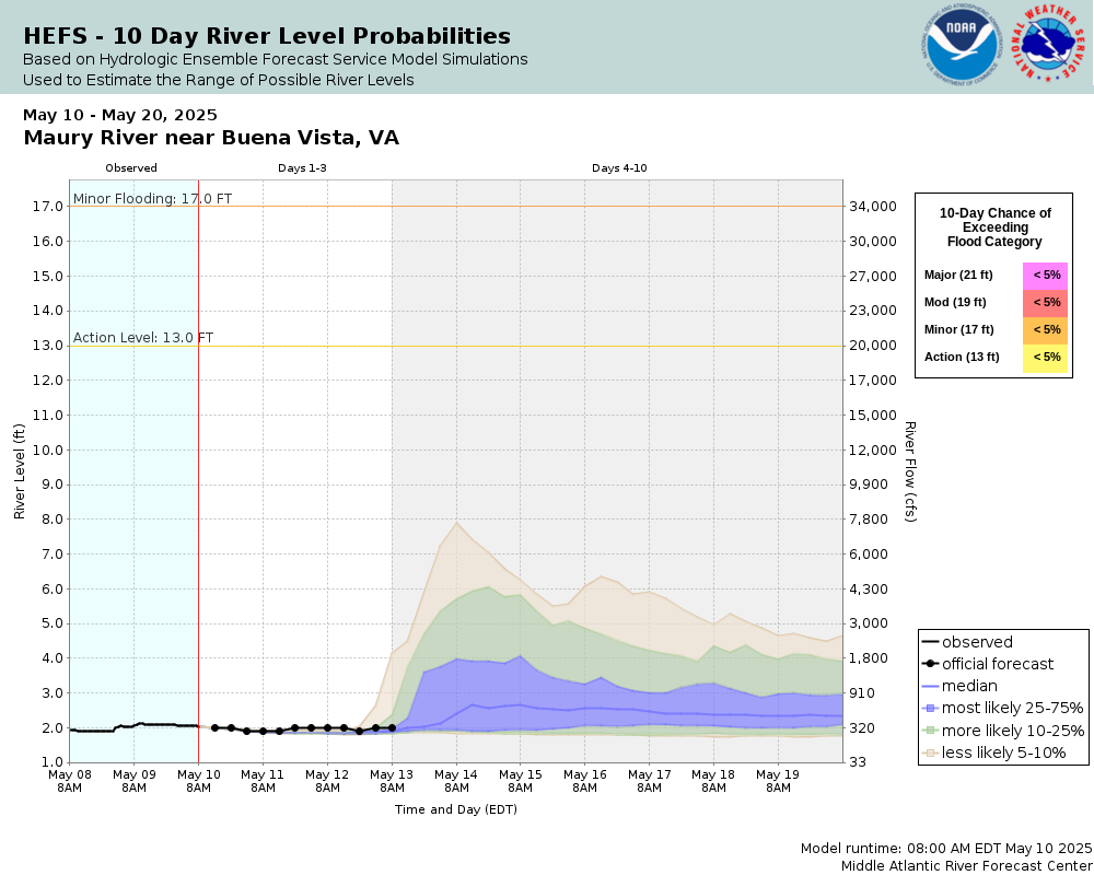 |
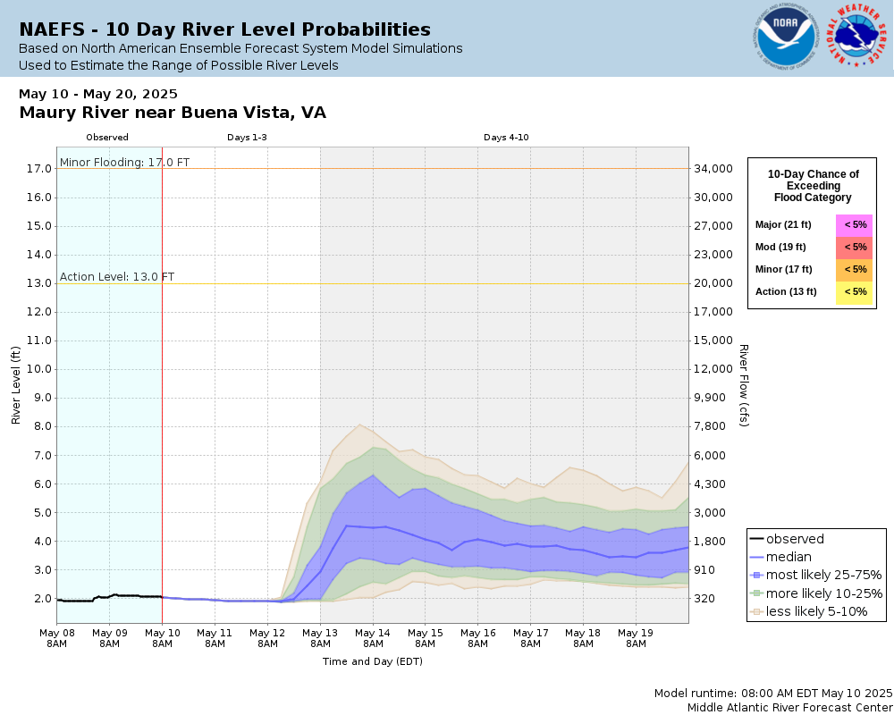 |
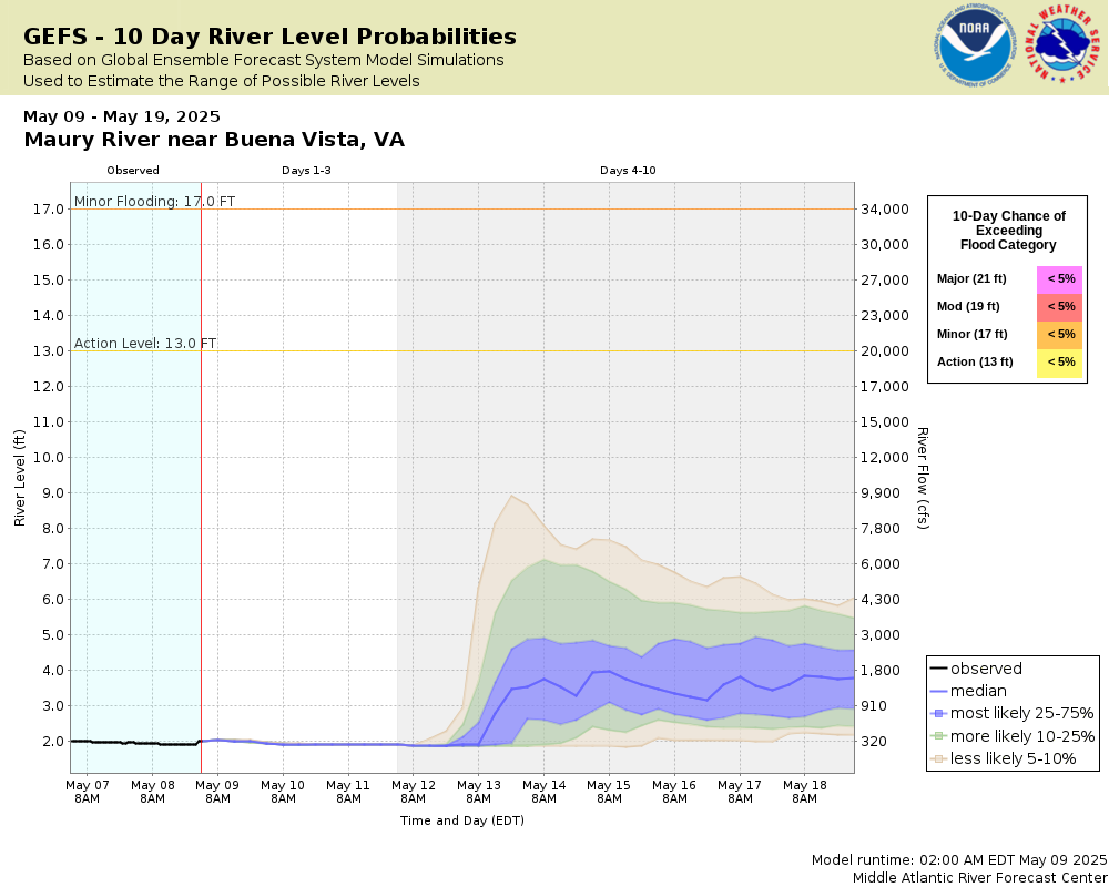 |
Note: Use the official hydrograph at the top of this web page for river levels within the next 48 hours.
Click individual graphics to enlarge.
Collaborative Agencies
The National Weather Service prepares its forecasts and other services in collaboration with agencies like the US Geological Survey, US Bureau of Reclamation, US Army Corps of Engineers, Natural Resource Conservation Service, National Park Service, ALERT Users Group, Bureau of Indian Affairs, and many state and local emergency managers across the country. For details, please click here.