Sugar Creek (IN) at Crawfordsville
Future / Actual / Minor
OWP 2.0 WWA Modal Title
01/11/2021, 10:04 PM UTC through 01/11/2021, 10:04 PM UTC
Sender
Sent
- Warning: no valid ratings curve available. Transformations to and from FEET/CFS/KCFS will not happen.
Traces and Thresholds Click to turn on/off display
Observed (OBS) 06/24/2025 5:45 AM EDTRecord: 17.3 ftCATEGORY STAGE 
Major Flooding 21 ft Moderate Flooding 17 ft Minor Flooding 15 ft Action 12 ft Reliability of the Forecast: Based on current and forecast river, weather and reservoir conditions
NOTE: Forecasts are issued as needed during times of high water, but are not routinely available.
Due to the removal of a nearby low-head dam, the USGS relocated this gauge from just upstream of the U.S. Highway 231 bridge to the bridge at Lafayette Avenue which resulted in changes to the gauge heights and datum. See the Additional Information section further down on this page for more details.
National Water Model Hydrograph
Official NWS streamflow forecasts are produced by NWS hydrologic forecasters for river gauge locations using hydrologic models which are calibrated to that location. This process considers additional guidance and information, including local expertise and experience, to produce the best forecast possible. The NWM output provides supplemental guidance to NWS forecasters and should not be considered an official NWS river forecast.
Flood Impacts
- 24.5 - Record flooding. Businesses and homes flooded. Numerous roads underwater.
- 23 - Near record flooding is in progress.
- 21 - Major flooding is in progress. Evacuations necessary along SR 234 just east of Shades State Park. Buildings at Crawfordsville Power Plant flood. Business and residence just north of Sugar Creek along U.S. 231 flood.
Gauge Info
| Coordinates | 40.0503, -86.9072 |
| RFC | OHRFC |
| State | IN |
| WFO | IND |
| County | Montgomery |
| Data Provider(s) | |
| US Geological Survey | USGS--Water Resources of the United States |
| USGS | 03339500 |
Gauge Location
Recent Crests
| 1. | 8.08 ft | on 09-25-2018 | 1 |
| 2. | 10.50 ft | on 04-04-2018 | 1 |
| 3. | 5.63 ft | on 02-21-2018 | 1 |
| 4. | 5.99 ft | on 11-19-2017 | 1 |
| 5. | 7.36 ft | on 07-12-2017 | 1 |
Recent Crests
| 1. | 8.08 ft | on 09-25-2018 | 1 |
| 2. | 10.50 ft | on 04-04-2018 | 1 |
| 3. | 5.63 ft | on 02-21-2018 | 1 |
| 4. | 5.99 ft | on 11-19-2017 | 1 |
| 5. | 7.36 ft | on 07-12-2017 | 1 |
| 6. | 4.53 ft | on 06-18-2017 | 1 |
| 7. | 10.77 ft | on 05-05-2017 | 1 |
| 8. | 4.72 ft | on 04-06-2017 | 1 |
| 9. | 6.35 ft | on 01-20-2017 | 1 |
| 10. | 8.68 ft | on 12-27-2015 | 1 |
| 11. | 9.17 ft | on 06-27-2015 | 1 |
| 12. | 7.33 ft | on 04-04-2014 | 1 |
| 13. | 15.33 ft | on 04-19-2013 | 1 |
| 14. | 8.09 ft | on 01-14-2013 | 1 |
| 15. | 9.41 ft | on 04-28-2011 | 1 |
| 16. | 8.83 ft | on 03-01-2011 | 1 |
| 17. | 8.11 ft | on 06-23-2010 | 1 |
| 18. | 10.34 ft | on 02-12-2009 | 1 |
| 19. | 8.30 ft | on 06-08-2008 | 1 |
| 20. | 8.46 ft | on 02-06-2008 | 1 |
| 21. | 4.66 ft | on 01-09-2008 | 1 |
| 22. | 7.45 ft | on 01-15-2007 | 1 |
| 23. | 6.52 ft | on 12-01-2006 | 1 |
| 24. | 8.80 ft | on 01-13-2005 | 1 |
| 25. | 8.98 ft | on 01-12-2005 | 1 |
| 26. | 8.78 ft | on 01-06-2005 | 1 |
| 27. | 4.56 ft | on 06-17-2004 | 1 |
| 28. | 4.68 ft | on 06-16-2004 | 1 |
| 29. | 5.25 ft | on 06-12-2004 | 1 |
| 30. | 8.30 ft | on 01-05-2004 | 1 |
| 31. | 12.32 ft | on 05-13-2002 | 1 |
| 32. | 5.39 ft | on 02-10-2001 | 1 |
| 33. | 5.02 ft | on 08-18-2000 | 1 |
| 34. | 10.93 ft | on 01-22-1999 | 1 |
| 35. | 12.43 ft | on 06-12-1998 | 1 |
| 36. | 5.45 ft | on 05-08-1998 | 1 |
| 37. | 5.20 ft | on 03-20-1998 | 1 |
| 38. | 7.20 ft | on 03-14-1997 | 1 |
| 39. | 10.28 ft | on 02-27-1997 | 1 |
| 40. | 3.69 ft | on 02-04-1997 | 1 |
| 41. | 6.40 ft | on 05-27-1996 | 1 |
| 42. | 8.45 ft | on 05-24-1996 | 1 |
| 43. | 7.11 ft | on 05-11-1996 | 1 |
| 44. | 6.36 ft | on 03-07-1995 | 1 |
| 45. | 6.79 ft | on 04-12-1994 | 1 |
| 46. | 8.26 ft | on 11-17-1993 | 1 |
| 47. | 7.49 ft | on 11-15-1993 | 1 |
| 48. | 5.21 ft | on 03-05-1993 | 1 |
| 49. | 9.00 ft | on 01-05-1993 | 1 |
| 50. | 11.50 ft | on 11-13-1992 | 1 |
| 51. | 7.50 ft | on 11-02-1992 | 1 |
| 52. | 4.91 ft | on 07-31-1992 | 1 |
| 53. | 6.75 ft | on 04-18-1992 | 1 |
| 54. | 5.48 ft | on 06-01-1991 | 1 |
| 55. | 4.59 ft | on 03-23-1991 | 1 |
| 56. | 5.25 ft | on 03-13-1991 | 1 |
| 57. | 13.19 ft | on 12-30-1990 | 1 |
| 58. | 4.51 ft | on 12-22-1990 | 1 |
| 59. | 5.26 ft | on 07-12-1990 | 1 |
| 60. | 4.90 ft | on 07-10-1990 | 1 |
| 61. | 7.37 ft | on 06-09-1990 | 1 |
| 62. | 5.35 ft | on 05-16-1990 | 1 |
| 63. | 9.51 ft | on 03-12-1990 | 1 |
| 64. | 4.61 ft | on 02-22-1990 | 1 |
| 65. | 5.69 ft | on 02-15-1990 | 1 |
| 66. | 6.00 ft | on 09-14-1989 | 1 |
| 67. | 6.54 ft | on 09-10-1989 | 1 |
| 68. | 6.01 ft | on 09-02-1989 | 1 |
| 69. | 5.11 ft | on 08-29-1989 | 1 |
| 70. | 5.47 ft | on 07-21-1989 | 1 |
| 71. | 7.51 ft | on 05-26-1989 | 1 |
| 72. | 4.38 ft | on 04-29-1989 | 1 |
| 73. | 4.30 ft | on 04-04-1989 | 1 |
| 74. | 5.89 ft | on 04-07-1988 | 1 |
| 75. | 3.82 ft | on 06-02-1987 | 1 |
| 76. | 4.48 ft | on 06-07-1986 | 1 |
| 77. | 5.24 ft | on 03-19-1986 | 1 |
| 78. | 7.74 ft | on 12-11-1985 | 1 |
| 79. | 6.10 ft | on 11-27-1985 | 1 |
| 80. | 7.60 ft | on 11-20-1985 | 1 |
| 81. | 4.51 ft | on 04-06-1985 | 1 |
| 82. | 5.58 ft | on 03-11-1985 | 1 |
| 83. | 4.45 ft | on 03-08-1985 | 1 |
| 84. | 4.37 ft | on 03-05-1985 | 1 |
| 85. | 12.44 ft | on 02-24-1985 | 1 |
| 86. | 5.63 ft | on 01-01-1985 | 1 |
| 87. | 4.29 ft | on 04-22-1984 | 1 |
| 88. | 4.93 ft | on 03-20-1984 | 1 |
| 89. | 5.47 ft | on 03-16-1984 | 1 |
| 90. | 4.59 ft | on 02-13-1984 | 1 |
| 91. | 4.59 ft | on 12-12-1983 | 1 |
| 92. | 7.14 ft | on 05-02-1983 | 1 |
| 93. | 4.35 ft | on 04-14-1983 | 1 |
| 94. | 6.05 ft | on 12-25-1982 | 1 |
| 95. | 4.40 ft | on 05-30-1982 | 1 |
| 96. | 4.48 ft | on 03-20-1982 | 1 |
| 97. | 5.52 ft | on 03-11-1982 | 1 |
| 98. | 5.59 ft | on 03-04-1982 | 1 |
| 99. | 5.49 ft | on 02-24-1982 | 1 |
| 100. | 6.05 ft | on 02-21-1982 | 1 |
| 101. | 5.34 ft | on 01-30-1982 | 1 |
| 102. | 5.01 ft | on 01-04-1982 | 1 |
| 103. | 9.95 ft | on 08-31-1981 | 1 |
| 104. | 5.26 ft | on 05-14-1981 | 1 |
| 105. | 4.30 ft | on 05-11-1981 | 1 |
| 106. | 5.62 ft | on 06-08-1980 | 1 |
| 107. | 6.18 ft | on 06-02-1980 | 1 |
| 108. | 4.85 ft | on 03-17-1980 | 1 |
| 109. | 4.90 ft | on 03-08-1980 | 1 |
| 110. | 4.36 ft | on 02-22-1980 | 1 |
| 111. | 4.76 ft | on 08-01-1979 | 1 |
| 112. | 4.99 ft | on 07-29-1979 | 1 |
| 113. | 5.13 ft | on 07-26-1979 | 1 |
| 114. | 4.60 ft | on 04-12-1979 | 1 |
| 115. | 7.75 ft | on 03-04-1979 | 1 |
| 116. | 6.09 ft | on 02-23-1979 | 1 |
| 117. | 4.44 ft | on 01-01-1979 | 1 |
| 118. | 4.46 ft | on 08-28-1978 | 1 |
| 119. | 9.39 ft | on 06-27-1978 | 1 |
| 120. | 4.32 ft | on 05-13-1978 | 1 |
| 121. | 4.36 ft | on 03-27-1978 | 1 |
| 122. | 6.22 ft | on 03-21-1978 | 1 |
| 123. | 6.12 ft | on 03-16-1978 | 1 |
| 124. | 5.18 ft | on 12-17-1977 | 1 |
| 125. | 5.12 ft | on 12-15-1977 | 1 |
| 126. | 5.39 ft | on 07-08-1977 | 1 |
| 127. | 5.70 ft | on 06-30-1976 | 1 |
| 128. | 4.56 ft | on 03-05-1976 | 1 |
| 129. | 7.25 ft | on 02-17-1976 | 1 |
| 130. | 7.85 ft | on 02-11-1976 | 1 |
| 131. | 5.27 ft | on 07-18-1975 | 1 |
| 132. | 4.54 ft | on 05-23-1975 | 1 |
| 133. | 5.68 ft | on 04-25-1975 | 1 |
| 134. | 5.13 ft | on 03-29-1975 | 1 |
| 135. | 6.58 ft | on 02-23-1975 | 1 |
| 136. | 5.25 ft | on 01-11-1975 | 1 |
| 137. | 8.45 ft | on 06-22-1974 | 1 |
| 138. | 7.89 ft | on 05-20-1974 | 1 |
| 139. | 6.30 ft | on 04-04-1974 | 1 |
| 140. | 5.20 ft | on 03-30-1974 | 1 |
| 141. | 5.22 ft | on 01-27-1974 | 1 |
| 142. | 6.00 ft | on 01-23-1974 | 1 |
| 143. | 7.45 ft | on 01-19-1974 | 1 |
| 144. | 7.38 ft | on 12-26-1973 | 1 |
| 145. | 4.98 ft | on 11-28-1973 | 1 |
| 146. | 4.72 ft | on 04-23-1973 | 1 |
| 147. | 4.68 ft | on 03-26-1973 | 1 |
| 148. | 4.65 ft | on 03-17-1973 | 1 |
| 149. | 5.54 ft | on 03-14-1973 | 1 |
| 150. | 4.92 ft | on 03-11-1973 | 1 |
| 151. | 5.48 ft | on 12-31-1972 | 1 |
| 152. | 5.55 ft | on 12-13-1972 | 1 |
| 153. | 5.53 ft | on 11-14-1972 | 1 |
| 154. | 6.67 ft | on 11-02-1972 | 1 |
| 155. | 4.75 ft | on 09-27-1972 | 1 |
| 156. | 5.14 ft | on 07-03-1972 | 1 |
| 157. | 8.27 ft | on 04-20-1972 | 1 |
| 158. | 5.34 ft | on 12-15-1971 | 1 |
| 159. | 4.87 ft | on 06-12-1971 | 1 |
| 160. | 4.99 ft | on 05-24-1971 | 1 |
| 161. | 5.24 ft | on 02-22-1971 | 1 |
| 162. | 5.49 ft | on 02-20-1971 | 1 |
| 163. | 5.48 ft | on 02-04-1971 | 1 |
| 164. | 5.79 ft | on 04-24-1970 | 1 |
| 165. | 5.64 ft | on 04-20-1970 | 1 |
| 166. | 5.80 ft | on 11-20-1969 | 1 |
| 167. | 6.51 ft | on 10-12-1969 | 1 |
| 168. | 9.35 ft | on 01-30-1969 | 1 |
| 169. | 5.95 ft | on 01-18-1969 | 1 |
| 170. | 4.98 ft | on 12-28-1968 | 1 |
| 171. | 4.47 ft | on 05-27-1968 | 1 |
| 172. | 5.64 ft | on 05-24-1968 | 1 |
| 173. | 4.85 ft | on 04-04-1968 | 1 |
| 174. | 7.12 ft | on 02-02-1968 | 1 |
| 175. | 5.73 ft | on 01-30-1968 | 1 |
| 176. | 10.88 ft | on 12-21-1967 | 1 |
| 177. | 9.28 ft | on 12-09-1966 | 1 |
| 178. | 3.36 ft | on 02-11-1966 | 1 |
| 179. | 4.56 ft | on 06-06-1965 | 1 |
| 180. | 6.04 ft | on 05-25-1965 | 1 |
| 181. | 5.39 ft | on 04-09-1965 | 1 |
| 182. | 5.38 ft | on 04-06-1965 | 1 |
| 183. | 5.04 ft | on 02-10-1965 | 1 |
| 184. | 13.40 ft | on 04-21-1964 | 1 |
| 185. | 5.00 ft | on 03-09-1964 | 1 |
| 186. | 4.48 ft | on 04-01-1963 | 1 |
| 187. | 11.17 ft | on 03-04-1963 | 1 |
| 188. | 7.84 ft | on 07-14-1962 | 1 |
| 189. | 6.61 ft | on 03-21-1962 | 1 |
| 190. | 6.10 ft | on 02-26-1962 | 1 |
| 191. | 11.22 ft | on 01-27-1962 | 1 |
| 192. | 7.21 ft | on 06-09-1961 | 1 |
| 193. | 5.27 ft | on 05-09-1961 | 1 |
| 194. | 7.29 ft | on 04-25-1961 | 1 |
| 195. | 7.78 ft | on 04-22-1961 | 1 |
| 196. | 5.25 ft | on 03-13-1961 | 1 |
| 197. | 6.95 ft | on 06-23-1960 | 1 |
| 198. | 4.88 ft | on 02-10-1960 | 1 |
| 199. | 4.55 ft | on 04-28-1959 | 1 |
| 200. | 10.97 ft | on 02-10-1959 | 1 |
| 201. | 9.52 ft | on 01-21-1959 | 1 |
| 202. | 5.25 ft | on 11-26-1958 | 1 |
| 203. | 5.32 ft | on 11-17-1958 | 1 |
| 204. | 4.67 ft | on 08-15-1958 | 1 |
| 205. | 11.24 ft | on 08-03-1958 | 1 |
| 206. | 4.65 ft | on 07-12-1958 | 1 |
| 207. | 10.23 ft | on 06-14-1958 | 1 |
| 208. | 10.44 ft | on 06-11-1958 | 1 |
| 209. | 5.37 ft | on 12-26-1957 | 1 |
| 210. | 8.34 ft | on 12-20-1957 | 1 |
| 211. | 14.40 ft | on 06-28-1957 | 1 |
| 212. | 5.20 ft | on 06-13-1957 | 1 |
| 213. | 5.22 ft | on 05-20-1957 | 1 |
| 214. | 7.75 ft | on 04-04-1957 | 1 |
| 215. | 12.33 ft | on 05-28-1956 | 1 |
| 216. | 5.13 ft | on 02-25-1956 | 1 |
| 217. | 4.65 ft | on 02-18-1956 | 1 |
| 218. | 4.61 ft | on 11-16-1955 | 1 |
| 219. | 6.44 ft | on 01-06-1955 | 1 |
| 220. | 3.74 ft | on 05-02-1954 | 1 |
| 221. | 4.64 ft | on 05-25-1953 | 1 |
| 222. | 4.50 ft | on 03-18-1953 | 1 |
| 223. | 7.30 ft | on 03-04-1953 | 1 |
| 224. | 5.08 ft | on 06-22-1952 | 1 |
| 225. | 5.13 ft | on 06-14-1952 | 1 |
| 226. | 5.20 ft | on 05-24-1952 | 1 |
| 227. | 7.30 ft | on 04-13-1952 | 1 |
| 228. | 5.55 ft | on 03-11-1952 | 1 |
| 229. | 5.15 ft | on 02-04-1952 | 1 |
| 230. | 7.17 ft | on 01-27-1952 | 1 |
| 231. | 8.32 ft | on 02-21-1951 | 1 |
| 232. | 5.21 ft | on 12-03-1950 | 1 |
| 233. | 5.45 ft | on 11-20-1950 | 1 |
| 234. | 4.48 ft | on 09-22-1950 | 1 |
| 235. | 12.35 ft | on 09-01-1950 | 1 |
| 236. | 5.72 ft | on 07-09-1950 | 1 |
| 237. | 7.70 ft | on 06-25-1950 | 1 |
| 238. | 4.62 ft | on 06-17-1950 | 1 |
| 239. | 7.94 ft | on 04-04-1950 | 1 |
| 240. | 6.10 ft | on 03-28-1950 | 1 |
| 241. | 8.80 ft | on 02-14-1950 | 1 |
| 242. | 4.85 ft | on 02-09-1950 | 1 |
| 243. | 7.37 ft | on 01-26-1950 | 1 |
| 244. | 7.75 ft | on 01-15-1950 | 1 |
| 245. | 8.46 ft | on 01-10-1950 | 1 |
| 246. | 13.12 ft | on 01-04-1950 | 1 |
| 247. | 5.42 ft | on 01-03-1950 | 1 |
| 248. | 8.71 ft | on 02-15-1949 | 1 |
| 249. | 6.47 ft | on 01-28-1949 | 1 |
| 250. | 10.66 ft | on 01-19-1949 | 1 |
| 251. | 8.30 ft | on 01-05-1949 | 1 |
| 252. | 4.77 ft | on 12-29-1948 | 1 |
| 253. | 7.43 ft | on 04-13-1948 | 1 |
| 254. | 11.14 ft | on 04-06-1948 | 1 |
| 255. | 8.43 ft | on 03-27-1948 | 1 |
| 256. | 5.90 ft | on 03-23-1948 | 1 |
| 257. | 5.15 ft | on 02-28-1948 | 1 |
| 258. | 4.98 ft | on 06-07-1947 | 1 |
| 259. | 7.15 ft | on 04-30-1947 | 1 |
| 260. | 4.76 ft | on 04-25-1947 | 1 |
| 261. | 5.82 ft | on 01-30-1947 | 1 |
| 262. | 7.43 ft | on 06-19-1946 | 1 |
| 263. | 6.01 ft | on 05-18-1946 | 1 |
| 264. | 8.05 ft | on 02-14-1946 | 1 |
| 265. | 5.30 ft | on 12-30-1945 | 1 |
| 266. | 4.50 ft | on 10-01-1945 | 1 |
| 267. | 6.21 ft | on 06-16-1945 | 1 |
| 268. | 8.28 ft | on 05-17-1945 | 1 |
| 269. | 8.11 ft | on 03-31-1945 | 1 |
| 270. | 8.18 ft | on 04-23-1944 | 1 |
| 271. | 9.35 ft | on 04-11-1944 | 1 |
| 272. | 14.02 ft | on 05-18-1943 | 1 |
| 273. | 11.21 ft | on 05-11-1943 | 1 |
| 274. | 5.57 ft | on 06-13-1942 | 1 |
| 275. | 5.72 ft | on 02-07-1942 | 1 |
| 276. | 2.73 ft | on 05-12-1941 | 1 |
| 277. | 4.62 ft | on 04-18-1940 | 1 |
| 278. | 8.65 ft | on 07-18-1939 | 1 |
| 279. | 9.20 ft | on 04-17-1939 | 1 |
| 280. | 12.07 ft | on 03-12-1939 | 1 |
| 281. | 4.92 ft | on 02-20-1939 | 1 |
| 282. | 5.37 ft | on 01-30-1939 | 1 |
| 283. | 8.20 ft | on 01-12-1937 | 1 |
| 284. | 8.20 ft | on 01-01-1937 | 1 |
| 285. | 14.10 ft | on 05-21-1927 | 1 |
| 286. | 14.10 ft | on 03-24-1927 | 1 |
| 287. | 17.30 ft | on 03-27-1913 | 1 |
Historic Crests
| 1. | 17.30 ft | on 03-27-1913 | 1 |
| 2. | 15.33 ft | on 04-19-2013 | 1 |
| 3. | 14.40 ft | on 06-28-1957 | 1 |
| 4. | 14.10 ft | on 03-24-1927 | 1 |
| 5. | 14.10 ft | on 05-21-1927 | 1 |
Historic Crests
| 1. | 17.30 ft | on 03-27-1913 | 1 |
| 2. | 15.33 ft | on 04-19-2013 | 1 |
| 3. | 14.40 ft | on 06-28-1957 | 1 |
| 4. | 14.10 ft | on 03-24-1927 | 1 |
| 5. | 14.10 ft | on 05-21-1927 | 1 |
| 6. | 14.02 ft | on 05-18-1943 | 1 |
| 7. | 13.40 ft | on 04-21-1964 | 1 |
| 8. | 13.19 ft | on 12-30-1990 | 1 |
| 9. | 13.12 ft | on 01-04-1950 | 1 |
| 10. | 12.44 ft | on 02-24-1985 | 1 |
| 11. | 12.43 ft | on 06-12-1998 | 1 |
| 12. | 12.35 ft | on 09-01-1950 | 1 |
| 13. | 12.33 ft | on 05-28-1956 | 1 |
| 14. | 12.32 ft | on 05-13-2002 | 1 |
| 15. | 12.07 ft | on 03-12-1939 | 1 |
| 16. | 11.50 ft | on 11-13-1992 | 1 |
| 17. | 11.24 ft | on 08-03-1958 | 1 |
| 18. | 11.22 ft | on 01-27-1962 | 1 |
| 19. | 11.21 ft | on 05-11-1943 | 1 |
| 20. | 11.17 ft | on 03-04-1963 | 1 |
| 21. | 11.14 ft | on 04-06-1948 | 1 |
| 22. | 10.97 ft | on 02-10-1959 | 1 |
| 23. | 10.93 ft | on 01-22-1999 | 1 |
| 24. | 10.88 ft | on 12-21-1967 | 1 |
| 25. | 10.77 ft | on 05-05-2017 | 1 |
| 26. | 10.66 ft | on 01-19-1949 | 1 |
| 27. | 10.50 ft | on 04-04-2018 | 1 |
| 28. | 10.44 ft | on 06-11-1958 | 1 |
| 29. | 10.34 ft | on 02-12-2009 | 1 |
| 30. | 10.28 ft | on 02-27-1997 | 1 |
| 31. | 10.23 ft | on 06-14-1958 | 1 |
| 32. | 9.95 ft | on 08-31-1981 | 1 |
| 33. | 9.52 ft | on 01-21-1959 | 1 |
| 34. | 9.51 ft | on 03-12-1990 | 1 |
| 35. | 9.41 ft | on 04-28-2011 | 1 |
| 36. | 9.39 ft | on 06-27-1978 | 1 |
| 37. | 9.35 ft | on 01-30-1969 | 1 |
| 38. | 9.35 ft | on 04-11-1944 | 1 |
| 39. | 9.28 ft | on 12-09-1966 | 1 |
| 40. | 9.20 ft | on 04-17-1939 | 1 |
| 41. | 9.17 ft | on 06-27-2015 | 1 |
| 42. | 9.00 ft | on 01-05-1993 | 1 |
| 43. | 8.98 ft | on 01-12-2005 | 1 |
| 44. | 8.83 ft | on 03-01-2011 | 1 |
| 45. | 8.80 ft | on 02-14-1950 | 1 |
| 46. | 8.80 ft | on 01-13-2005 | 1 |
| 47. | 8.78 ft | on 01-06-2005 | 1 |
| 48. | 8.71 ft | on 02-15-1949 | 1 |
| 49. | 8.68 ft | on 12-27-2015 | 1 |
| 50. | 8.65 ft | on 07-18-1939 | 1 |
| 51. | 8.46 ft | on 02-06-2008 | 1 |
| 52. | 8.46 ft | on 01-10-1950 | 1 |
| 53. | 8.45 ft | on 06-22-1974 | 1 |
| 54. | 8.45 ft | on 05-24-1996 | 1 |
| 55. | 8.43 ft | on 03-27-1948 | 1 |
| 56. | 8.34 ft | on 12-20-1957 | 1 |
| 57. | 8.32 ft | on 02-21-1951 | 1 |
| 58. | 8.30 ft | on 01-05-2004 | 1 |
| 59. | 8.30 ft | on 01-05-1949 | 1 |
| 60. | 8.30 ft | on 06-08-2008 | 1 |
| 61. | 8.28 ft | on 05-17-1945 | 1 |
| 62. | 8.27 ft | on 04-20-1972 | 1 |
| 63. | 8.26 ft | on 11-17-1993 | 1 |
| 64. | 8.20 ft | on 01-12-1937 | 1 |
| 65. | 8.20 ft | on 01-01-1937 | 1 |
| 66. | 8.18 ft | on 04-23-1944 | 1 |
| 67. | 8.11 ft | on 03-31-1945 | 1 |
| 68. | 8.11 ft | on 06-23-2010 | 1 |
| 69. | 8.09 ft | on 01-14-2013 | 1 |
| 70. | 8.08 ft | on 09-25-2018 | 1 |
| 71. | 8.05 ft | on 02-14-1946 | 1 |
| 72. | 7.94 ft | on 04-04-1950 | 1 |
| 73. | 7.89 ft | on 05-20-1974 | 1 |
| 74. | 7.85 ft | on 02-11-1976 | 1 |
| 75. | 7.84 ft | on 07-14-1962 | 1 |
| 76. | 7.78 ft | on 04-22-1961 | 1 |
| 77. | 7.75 ft | on 03-04-1979 | 1 |
| 78. | 7.75 ft | on 04-04-1957 | 1 |
| 79. | 7.75 ft | on 01-15-1950 | 1 |
| 80. | 7.74 ft | on 12-11-1985 | 1 |
| 81. | 7.70 ft | on 06-25-1950 | 1 |
| 82. | 7.60 ft | on 11-20-1985 | 1 |
| 83. | 7.51 ft | on 05-26-1989 | 1 |
| 84. | 7.50 ft | on 11-02-1992 | 1 |
| 85. | 7.49 ft | on 11-15-1993 | 1 |
| 86. | 7.45 ft | on 01-19-1974 | 1 |
| 87. | 7.45 ft | on 01-15-2007 | 1 |
| 88. | 7.43 ft | on 04-13-1948 | 1 |
| 89. | 7.43 ft | on 06-19-1946 | 1 |
| 90. | 7.38 ft | on 12-26-1973 | 1 |
| 91. | 7.37 ft | on 06-09-1990 | 1 |
| 92. | 7.37 ft | on 01-26-1950 | 1 |
| 93. | 7.36 ft | on 07-12-2017 | 1 |
| 94. | 7.33 ft | on 04-04-2014 | 1 |
| 95. | 7.30 ft | on 03-04-1953 | 1 |
| 96. | 7.30 ft | on 04-13-1952 | 1 |
| 97. | 7.29 ft | on 04-25-1961 | 1 |
| 98. | 7.25 ft | on 02-17-1976 | 1 |
| 99. | 7.21 ft | on 06-09-1961 | 1 |
| 100. | 7.20 ft | on 03-14-1997 | 1 |
| 101. | 7.17 ft | on 01-27-1952 | 1 |
| 102. | 7.15 ft | on 04-30-1947 | 1 |
| 103. | 7.14 ft | on 05-02-1983 | 1 |
| 104. | 7.12 ft | on 02-02-1968 | 1 |
| 105. | 7.11 ft | on 05-11-1996 | 1 |
| 106. | 6.95 ft | on 06-23-1960 | 1 |
| 107. | 6.79 ft | on 04-12-1994 | 1 |
| 108. | 6.75 ft | on 04-18-1992 | 1 |
| 109. | 6.67 ft | on 11-02-1972 | 1 |
| 110. | 6.61 ft | on 03-21-1962 | 1 |
| 111. | 6.58 ft | on 02-23-1975 | 1 |
| 112. | 6.54 ft | on 09-10-1989 | 1 |
| 113. | 6.52 ft | on 12-01-2006 | 1 |
| 114. | 6.51 ft | on 10-12-1969 | 1 |
| 115. | 6.47 ft | on 01-28-1949 | 1 |
| 116. | 6.44 ft | on 01-06-1955 | 1 |
| 117. | 6.40 ft | on 05-27-1996 | 1 |
| 118. | 6.36 ft | on 03-07-1995 | 1 |
| 119. | 6.35 ft | on 01-20-2017 | 1 |
| 120. | 6.30 ft | on 04-04-1974 | 1 |
| 121. | 6.22 ft | on 03-21-1978 | 1 |
| 122. | 6.21 ft | on 06-16-1945 | 1 |
| 123. | 6.18 ft | on 06-02-1980 | 1 |
| 124. | 6.12 ft | on 03-16-1978 | 1 |
| 125. | 6.10 ft | on 11-27-1985 | 1 |
| 126. | 6.10 ft | on 02-26-1962 | 1 |
| 127. | 6.10 ft | on 03-28-1950 | 1 |
| 128. | 6.09 ft | on 02-23-1979 | 1 |
| 129. | 6.05 ft | on 12-25-1982 | 1 |
| 130. | 6.05 ft | on 02-21-1982 | 1 |
| 131. | 6.04 ft | on 05-25-1965 | 1 |
| 132. | 6.01 ft | on 05-18-1946 | 1 |
| 133. | 6.01 ft | on 09-02-1989 | 1 |
| 134. | 6.00 ft | on 09-14-1989 | 1 |
| 135. | 6.00 ft | on 01-23-1974 | 1 |
| 136. | 5.99 ft | on 11-19-2017 | 1 |
| 137. | 5.95 ft | on 01-18-1969 | 1 |
| 138. | 5.90 ft | on 03-23-1948 | 1 |
| 139. | 5.89 ft | on 04-07-1988 | 1 |
| 140. | 5.82 ft | on 01-30-1947 | 1 |
| 141. | 5.80 ft | on 11-20-1969 | 1 |
| 142. | 5.79 ft | on 04-24-1970 | 1 |
| 143. | 5.73 ft | on 01-30-1968 | 1 |
| 144. | 5.72 ft | on 02-07-1942 | 1 |
| 145. | 5.72 ft | on 07-09-1950 | 1 |
| 146. | 5.70 ft | on 06-30-1976 | 1 |
| 147. | 5.69 ft | on 02-15-1990 | 1 |
| 148. | 5.68 ft | on 04-25-1975 | 1 |
| 149. | 5.64 ft | on 04-20-1970 | 1 |
| 150. | 5.64 ft | on 05-24-1968 | 1 |
| 151. | 5.63 ft | on 01-01-1985 | 1 |
| 152. | 5.63 ft | on 02-21-2018 | 1 |
| 153. | 5.62 ft | on 06-08-1980 | 1 |
| 154. | 5.59 ft | on 03-04-1982 | 1 |
| 155. | 5.58 ft | on 03-11-1985 | 1 |
| 156. | 5.57 ft | on 06-13-1942 | 1 |
| 157. | 5.55 ft | on 12-13-1972 | 1 |
| 158. | 5.55 ft | on 03-11-1952 | 1 |
| 159. | 5.54 ft | on 03-14-1973 | 1 |
| 160. | 5.53 ft | on 11-14-1972 | 1 |
| 161. | 5.52 ft | on 03-11-1982 | 1 |
| 162. | 5.49 ft | on 02-20-1971 | 1 |
| 163. | 5.49 ft | on 02-24-1982 | 1 |
| 164. | 5.48 ft | on 06-01-1991 | 1 |
| 165. | 5.48 ft | on 02-04-1971 | 1 |
| 166. | 5.48 ft | on 12-31-1972 | 1 |
| 167. | 5.47 ft | on 07-21-1989 | 1 |
| 168. | 5.47 ft | on 03-16-1984 | 1 |
| 169. | 5.45 ft | on 11-20-1950 | 1 |
| 170. | 5.45 ft | on 05-08-1998 | 1 |
| 171. | 5.42 ft | on 01-03-1950 | 1 |
| 172. | 5.39 ft | on 04-09-1965 | 1 |
| 173. | 5.39 ft | on 02-10-2001 | 1 |
| 174. | 5.39 ft | on 07-08-1977 | 1 |
| 175. | 5.38 ft | on 04-06-1965 | 1 |
| 176. | 5.37 ft | on 01-30-1939 | 1 |
| 177. | 5.37 ft | on 12-26-1957 | 1 |
| 178. | 5.35 ft | on 05-16-1990 | 1 |
| 179. | 5.34 ft | on 01-30-1982 | 1 |
| 180. | 5.34 ft | on 12-15-1971 | 1 |
| 181. | 5.32 ft | on 11-17-1958 | 1 |
| 182. | 5.30 ft | on 12-30-1945 | 1 |
| 183. | 5.27 ft | on 07-18-1975 | 1 |
| 184. | 5.27 ft | on 05-09-1961 | 1 |
| 185. | 5.26 ft | on 07-12-1990 | 1 |
| 186. | 5.26 ft | on 05-14-1981 | 1 |
| 187. | 5.25 ft | on 03-13-1991 | 1 |
| 188. | 5.25 ft | on 06-12-2004 | 1 |
| 189. | 5.25 ft | on 11-26-1958 | 1 |
| 190. | 5.25 ft | on 03-13-1961 | 1 |
| 191. | 5.25 ft | on 01-11-1975 | 1 |
| 192. | 5.24 ft | on 02-22-1971 | 1 |
| 193. | 5.24 ft | on 03-19-1986 | 1 |
| 194. | 5.22 ft | on 05-20-1957 | 1 |
| 195. | 5.22 ft | on 01-27-1974 | 1 |
| 196. | 5.21 ft | on 12-03-1950 | 1 |
| 197. | 5.21 ft | on 03-05-1993 | 1 |
| 198. | 5.20 ft | on 05-24-1952 | 1 |
| 199. | 5.20 ft | on 03-20-1998 | 1 |
| 200. | 5.20 ft | on 03-30-1974 | 1 |
| 201. | 5.20 ft | on 06-13-1957 | 1 |
| 202. | 5.18 ft | on 12-17-1977 | 1 |
| 203. | 5.15 ft | on 02-04-1952 | 1 |
| 204. | 5.15 ft | on 02-28-1948 | 1 |
| 205. | 5.14 ft | on 07-03-1972 | 1 |
| 206. | 5.13 ft | on 02-25-1956 | 1 |
| 207. | 5.13 ft | on 03-29-1975 | 1 |
| 208. | 5.13 ft | on 06-14-1952 | 1 |
| 209. | 5.13 ft | on 07-26-1979 | 1 |
| 210. | 5.12 ft | on 12-15-1977 | 1 |
| 211. | 5.11 ft | on 08-29-1989 | 1 |
| 212. | 5.08 ft | on 06-22-1952 | 1 |
| 213. | 5.04 ft | on 02-10-1965 | 1 |
| 214. | 5.02 ft | on 08-18-2000 | 1 |
| 215. | 5.01 ft | on 01-04-1982 | 1 |
| 216. | 5.00 ft | on 03-09-1964 | 1 |
| 217. | 4.99 ft | on 07-29-1979 | 1 |
| 218. | 4.99 ft | on 05-24-1971 | 1 |
| 219. | 4.98 ft | on 11-28-1973 | 1 |
| 220. | 4.98 ft | on 12-28-1968 | 1 |
| 221. | 4.98 ft | on 06-07-1947 | 1 |
| 222. | 4.93 ft | on 03-20-1984 | 1 |
| 223. | 4.92 ft | on 02-20-1939 | 1 |
| 224. | 4.92 ft | on 03-11-1973 | 1 |
| 225. | 4.91 ft | on 07-31-1992 | 1 |
| 226. | 4.90 ft | on 07-10-1990 | 1 |
| 227. | 4.90 ft | on 03-08-1980 | 1 |
| 228. | 4.88 ft | on 02-10-1960 | 1 |
| 229. | 4.87 ft | on 06-12-1971 | 1 |
| 230. | 4.85 ft | on 02-09-1950 | 1 |
| 231. | 4.85 ft | on 04-04-1968 | 1 |
| 232. | 4.85 ft | on 03-17-1980 | 1 |
| 233. | 4.77 ft | on 12-29-1948 | 1 |
| 234. | 4.76 ft | on 08-01-1979 | 1 |
| 235. | 4.76 ft | on 04-25-1947 | 1 |
| 236. | 4.75 ft | on 09-27-1972 | 1 |
| 237. | 4.72 ft | on 04-23-1973 | 1 |
| 238. | 4.72 ft | on 04-06-2017 | 1 |
| 239. | 4.68 ft | on 06-16-2004 | 1 |
| 240. | 4.68 ft | on 03-26-1973 | 1 |
| 241. | 4.67 ft | on 08-15-1958 | 1 |
| 242. | 4.66 ft | on 01-09-2008 | 1 |
| 243. | 4.65 ft | on 02-18-1956 | 1 |
| 244. | 4.65 ft | on 03-17-1973 | 1 |
| 245. | 4.65 ft | on 07-12-1958 | 1 |
| 246. | 4.64 ft | on 05-25-1953 | 1 |
| 247. | 4.62 ft | on 06-17-1950 | 1 |
| 248. | 4.62 ft | on 04-18-1940 | 1 |
| 249. | 4.61 ft | on 11-16-1955 | 1 |
| 250. | 4.61 ft | on 02-22-1990 | 1 |
| 251. | 4.60 ft | on 04-12-1979 | 1 |
| 252. | 4.59 ft | on 03-23-1991 | 1 |
| 253. | 4.59 ft | on 12-12-1983 | 1 |
| 254. | 4.59 ft | on 02-13-1984 | 1 |
| 255. | 4.56 ft | on 06-17-2004 | 1 |
| 256. | 4.56 ft | on 03-05-1976 | 1 |
| 257. | 4.56 ft | on 06-06-1965 | 1 |
| 258. | 4.55 ft | on 04-28-1959 | 1 |
| 259. | 4.54 ft | on 05-23-1975 | 1 |
| 260. | 4.53 ft | on 06-18-2017 | 1 |
| 261. | 4.51 ft | on 04-06-1985 | 1 |
| 262. | 4.51 ft | on 12-22-1990 | 1 |
| 263. | 4.50 ft | on 10-01-1945 | 1 |
| 264. | 4.50 ft | on 03-18-1953 | 1 |
| 265. | 4.48 ft | on 09-22-1950 | 1 |
| 266. | 4.48 ft | on 03-20-1982 | 1 |
| 267. | 4.48 ft | on 06-07-1986 | 1 |
| 268. | 4.48 ft | on 04-01-1963 | 1 |
| 269. | 4.47 ft | on 05-27-1968 | 1 |
| 270. | 4.46 ft | on 08-28-1978 | 1 |
| 271. | 4.45 ft | on 03-08-1985 | 1 |
| 272. | 4.44 ft | on 01-01-1979 | 1 |
| 273. | 4.40 ft | on 05-30-1982 | 1 |
| 274. | 4.38 ft | on 04-29-1989 | 1 |
| 275. | 4.37 ft | on 03-05-1985 | 1 |
| 276. | 4.36 ft | on 03-27-1978 | 1 |
| 277. | 4.36 ft | on 02-22-1980 | 1 |
| 278. | 4.35 ft | on 04-14-1983 | 1 |
| 279. | 4.32 ft | on 05-13-1978 | 1 |
| 280. | 4.30 ft | on 04-04-1989 | 1 |
| 281. | 4.30 ft | on 05-11-1981 | 1 |
| 282. | 4.29 ft | on 04-22-1984 | 1 |
| 283. | 3.82 ft | on 06-02-1987 | 1 |
| 284. | 3.74 ft | on 05-02-1954 | 1 |
| 285. | 3.69 ft | on 02-04-1997 | 1 |
| 286. | 3.36 ft | on 02-11-1966 | 1 |
| 287. | 2.73 ft | on 05-12-1941 | 1 |
Vertical Datum Table
| type | NAVD88 |
|---|---|
| major Flooding | 668.66 ft |
| moderate Flooding | 664.66 ft |
| minor Flooding | 662.66 ft |
| action | 659.66 ft |
| Latest Value | 652.20 ft |
| Gauge Zero | 647.66 ft |


Unique Local Info
|
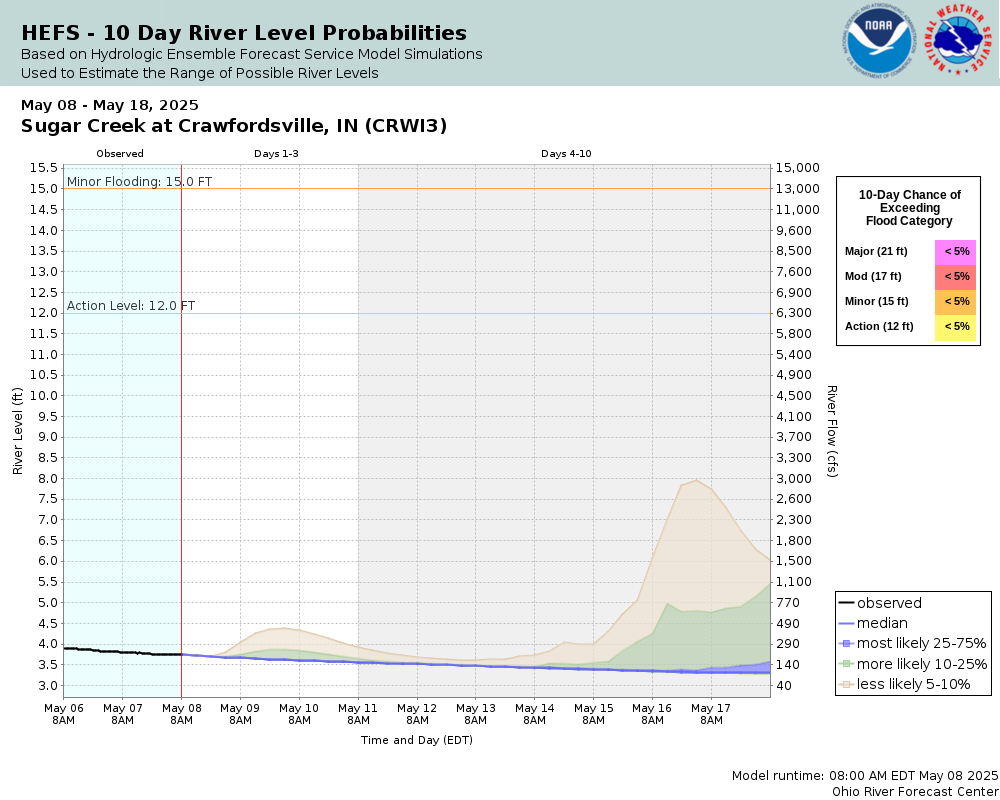
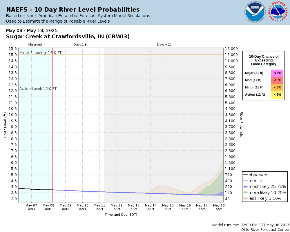
Potential River Levels Used to Estimate the Chance of Flooding and the Range of Possible River Levels |
||
| 10 Day (HEFS) | 10 Day (NAEFS) | 10 Day (GEFS) |
 |
 |
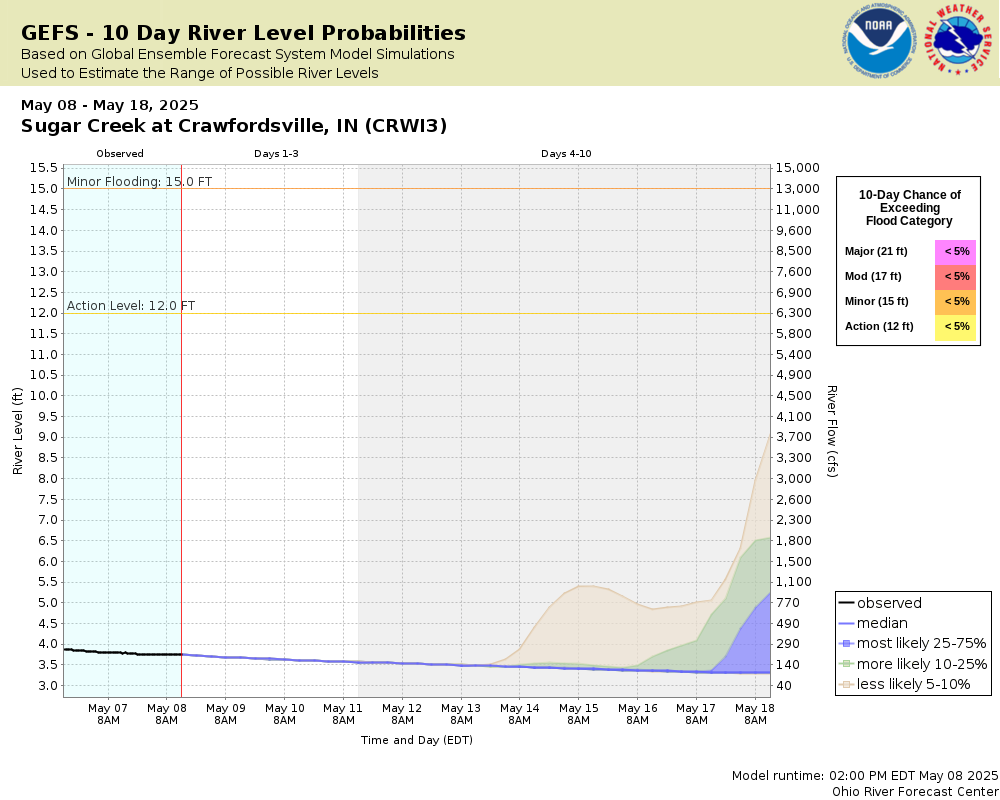 |
Note: Use the official hydrograph at the top of this web page for river levels within the next 72 hours.
Click individual graphics to enlarge.
The USGS relocated the Crawfordsville gauge from just upstream of the bridge at U.S. Hwy 231 to the bridge at Lafayette Ave following the removal of the low-head dam near the power plant. At higher gauge heights, readings on the gauge at Lafayette Ave bridge are estimated to be about 7 feet higher than the previous location. At lower gauge heights, the relationship is less straightforward. If you have questions please e–mail us at nws.indianapolis@noaa.gov. Crests listed from prior to April 2022 are from the prior location and unadjusted.Collaborative Agencies
The National Weather Service prepares its forecasts and other services in collaboration with agencies like the US Geological Survey, US Bureau of Reclamation, US Army Corps of Engineers, Natural Resource Conservation Service, National Park Service, ALERT Users Group, Bureau of Indian Affairs, and many state and local emergency managers across the country. For details, please click here.
Resources
Hydrologic Resource Links
- River Forecast Centers
- Text Products
- Forecast Precipitation
- US Geological Survey Surface Water
- How to Use US Geological Survey Water Alert Feature
- Water Resources Outlook
- Wabash River Conservation Area
- Water flow from Norway and Oakdale Dams
- Indianapolis Reservoir Levels
- Midwest Region U.S. Drought Monitor
- Indianapolis Museum of Art: FLOW Can You See the River?
- The Flood of 1913 - Remembered
- Friends of the White River
Additional Resource Links
- NWS Precipitation and River Forecasting
- Area Hydrographs
- Zoomable RFC Hourly Precipitation Maps
- Zoomable Snowfall Maps
- Indiana State Climate Office
- Community Collaborative Rain, Hail & Snow Network in Indiana
- Snow Information
- Midwestern Regional Climate Center
- Indiana Precipitation Frequencies
- Drainage Areas of Indiana Streams
- Ensemble River Forecasts
- Ohio River Forecast Center