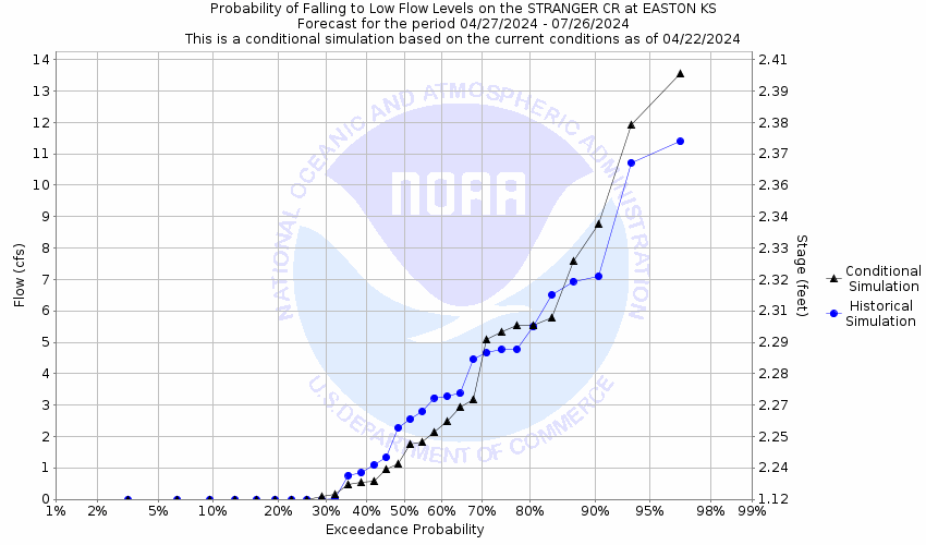
Stranger Creek at Easton
Future / Actual / Minor
OWP 2.0 WWA Modal Title
01/11/2021, 10:04 PM UTC through 01/11/2021, 10:04 PM UTC
Sender
Sent
- Upstream gauge unavailableWarning: no valid ratings curve available. Transformations to and from FEET/CFS/KCFS will not happen.
Traces and Thresholds Click to turn on/off display
Observed (OBS) 06/17/2025 4:30 PM CDTRecord: 27.8 ftLow Threshold: 1.5 ftCATEGORY STAGE 
Major Flooding 23 ft Moderate Flooding 18 ft Minor Flooding 17 ft Action 12 ft Reliability of the Forecast:
NOTE: Forecasts are issued as needed during times of high water, but are not routinely available.
River forecasts for this location take into account past precipitation and the precipitation amounts expected approximately 24 hours into the future from the forecast issuance time.
National Water Model Hydrograph
Official NWS streamflow forecasts are produced by NWS hydrologic forecasters for river gauge locations using hydrologic models which are calibrated to that location. This process considers additional guidance and information, including local expertise and experience, to produce the best forecast possible. The NWM output provides supplemental guidance to NWS forecasters and should not be considered an official NWS river forecast.
Flood Impacts
- 25.5 - Water floods numerous homes in Easton and also reaches the front steps of the St. Lawrence Catholic Church.
- 25 - Water overtops Highway 192 east of the bridge 0.2 miles east of Easton. The levee surrounding the waste treatment ponds is overtopped.
- 24 - The water treatment plant west of the former Easton grade school floods.
Gauge Location
Recent Crests
| 1. | 19.92 ft | on 02-01-2025 |
| 2. | 19.56 ft | on 06-09-2024 |
| 3. | 17.57 ft | on 06-25-2022 |
| 4. | 19.62 ft | on 06-01-2022 |
| 5. | 19.72 ft | on 05-26-2022 |
Recent Crests
| 1. | 19.92 ft | on 02-01-2025 |
| 2. | 19.56 ft | on 06-09-2024 |
| 3. | 17.57 ft | on 06-25-2022 |
| 4. | 19.62 ft | on 06-01-2022 |
| 5. | 19.72 ft | on 05-26-2022 |
| 6. | 17.22 ft | on 07-01-2021 |
| 7. | 19.98 ft | on 05-20-2021 |
| 8. | 18.19 ft | on 05-17-2021 |
| 9. | 21.42 ft | on 05-27-2020 |
| 10. | 18.00 ft | on 04-25-2020 |
| 11. | 18.37 ft | on 08-30-2019 |
| 12. | 20.17 ft | on 08-27-2019 |
| 13. | 20.11 ft | on 08-18-2019 |
| 14. | 20.49 ft | on 06-24-2019 |
| 15. | 18.05 ft | on 06-22-2019 |
| 16. | 19.83 ft | on 05-26-2019 |
| 17. | 20.31 ft | on 05-22-2019 |
| 18. | 19.79 ft | on 05-09-2019 |
| 19. | 18.83 ft | on 03-30-2019 |
| 20. | 18.16 ft | on 03-14-2019 |
| 21. | 18.56 ft | on 03-10-2019 |
| 22. | 17.58 ft | on 10-09-2018 |
| 23. | 21.11 ft | on 08-23-2017 |
| 24. | 19.78 ft | on 06-30-2017 |
| 25. | 19.72 ft | on 05-20-2017 |
| 26. | 19.95 ft | on 04-06-2017 |
| 27. | 18.66 ft | on 04-04-2017 |
| 28. | 17.97 ft | on 03-30-2017 |
| 29. | 21.19 ft | on 09-14-2016 |
| 30. | 18.05 ft | on 07-12-2016 |
| 31. | 19.05 ft | on 07-03-2016 |
| 32. | 21.42 ft | on 05-27-2016 |
| 33. | 19.60 ft | on 05-12-2016 |
| 34. | 19.47 ft | on 04-27-2016 |
| 35. | 18.07 ft | on 07-07-2015 |
| 36. | 20.90 ft | on 06-04-2015 |
| 37. | 19.50 ft | on 05-26-2015 |
| 38. | 20.00 ft | on 05-24-2015 |
| 39. | 20.50 ft | on 05-17-2015 |
| 40. | 19.40 ft | on 10-09-2014 |
| 41. | 18.50 ft | on 07-08-2014 |
| 42. | 18.05 ft | on 05-29-2013 |
| 43. | 19.00 ft | on 08-23-2011 |
| 44. | 18.72 ft | on 08-20-2011 |
| 45. | 19.00 ft | on 06-19-2011 |
| 46. | 20.30 ft | on 05-25-2011 |
| 47. | 18.45 ft | on 05-22-2011 |
| 48. | 19.15 ft | on 09-24-2010 |
| 49. | 18.90 ft | on 09-22-2010 |
| 50. | 18.95 ft | on 09-14-2010 |
| 51. | 17.27 ft | on 09-01-2010 |
| 52. | 17.38 ft | on 07-20-2010 |
| 53. | 19.10 ft | on 07-12-2010 |
| 54. | 18.05 ft | on 07-08-2010 |
| 55. | 18.93 ft | on 06-14-2010 |
| 56. | 19.50 ft | on 05-13-2010 |
| 57. | 18.90 ft | on 08-18-2009 |
| 58. | 19.96 ft | on 05-15-2009 |
| 59. | 19.70 ft | on 04-27-2009 |
| 60. | 17.94 ft | on 03-24-2009 |
| 61. | 19.00 ft | on 10-23-2008 |
| 62. | 19.85 ft | on 09-14-2008 |
| 63. | 17.35 ft | on 06-13-2008 |
| 64. | 17.99 ft | on 03-03-2008 |
| 65. | 18.65 ft | on 12-12-2007 |
| 66. | 17.62 ft | on 10-18-2007 |
| 67. | 27.80 ft | on 05-07-2007 |
| 68. | 19.70 ft | on 04-30-2006 |
| 69. | 26.00 ft | on 10-02-2005 |
| 70. | 19.97 ft | on 06-12-2005 |
| 71. | 20.20 ft | on 06-05-2005 |
| 72. | 19.65 ft | on 05-13-2005 |
| 73. | 17.25 ft | on 02-13-2005 |
| 74. | 18.45 ft | on 05-19-2004 |
| 75. | 18.50 ft | on 05-11-2002 |
| 76. | 20.56 ft | on 09-18-2001 |
| 77. | 17.88 ft | on 07-19-2001 |
| 78. | 19.25 ft | on 07-12-2001 |
| 79. | 25.90 ft | on 06-20-2001 |
| 80. | 20.40 ft | on 06-04-2001 |
| 81. | 17.10 ft | on 03-15-2001 |
| 82. | 19.95 ft | on 02-25-2001 |
| 83. | 18.42 ft | on 06-24-2000 |
| 84. | 21.94 ft | on 06-28-1999 |
| 85. | 19.70 ft | on 04-27-1999 |
| 86. | 20.40 ft | on 04-15-1999 |
| 87. | 18.35 ft | on 11-10-1998 |
| 88. | 21.35 ft | on 11-03-1998 |
| 89. | 20.25 ft | on 10-05-1998 |
| 90. | 18.00 ft | on 07-30-1998 |
| 91. | 17.20 ft | on 04-04-1998 |
| 92. | 21.43 ft | on 04-11-1997 |
| 93. | 19.05 ft | on 02-22-1997 |
| 94. | 17.80 ft | on 11-17-1996 |
| 95. | 18.70 ft | on 06-24-1996 |
| 96. | 22.00 ft | on 06-06-1996 |
| 97. | 19.90 ft | on 06-01-1996 |
| 98. | 20.30 ft | on 05-27-1996 |
| 99. | 17.00 ft | on 05-09-1996 |
| 100. | 18.50 ft | on 08-16-1995 |
| 101. | 18.60 ft | on 07-05-1995 |
| 102. | 18.00 ft | on 06-05-1995 |
| 103. | 20.00 ft | on 05-28-1995 |
| 104. | 20.33 ft | on 05-25-1995 |
| 105. | 18.10 ft | on 05-18-1995 |
| 106. | 18.00 ft | on 04-28-1994 |
| 107. | 19.86 ft | on 05-16-1990 |
| 108. | 17.50 ft | on 09-12-1989 |
| 109. | 18.00 ft | on 09-09-1989 |
| 110. | 19.00 ft | on 09-07-1989 |
| 111. | 18.06 ft | on 08-29-1989 |
| 112. | 18.85 ft | on 05-26-1987 |
| 113. | 18.18 ft | on 05-03-1987 |
| 114. | 19.35 ft | on 03-19-1987 |
| 115. | 19.20 ft | on 09-30-1986 |
| 116. | 21.00 ft | on 09-24-1986 |
| 117. | 20.30 ft | on 09-19-1986 |
| 118. | 19.70 ft | on 05-17-1986 |
| 119. | 21.00 ft | on 05-11-1986 |
| 120. | 17.10 ft | on 04-04-1986 |
| 121. | 21.86 ft | on 10-10-1985 |
| 122. | 20.29 ft | on 09-30-1985 |
| 123. | 21.13 ft | on 09-24-1985 |
| 124. | 21.00 ft | on 09-22-1985 |
| 125. | 18.70 ft | on 09-14-1985 |
| 126. | 20.00 ft | on 08-20-1985 |
| 127. | 17.35 ft | on 08-07-1985 |
| 128. | 17.45 ft | on 08-04-1985 |
| 129. | 18.50 ft | on 06-16-1984 |
| 130. | 20.00 ft | on 07-02-1982 |
| 131. | 24.00 ft | on 06-09-1982 |
| 132. | 18.35 ft | on 05-31-1982 |
| 133. | 18.90 ft | on 05-29-1982 |
| 134. | 22.00 ft | on 05-26-1982 |
| 135. | 17.95 ft | on 05-15-1982 |
| 136. | 19.50 ft | on 01-30-1982 |
| 137. | 22.00 ft | on 07-28-1981 |
| 138. | 17.90 ft | on 06-30-1981 |
| 139. | 17.60 ft | on 06-20-1981 |
| 140. | 17.55 ft | on 06-03-1981 |
| 141. | 19.95 ft | on 05-19-1981 |
| 142. | 18.75 ft | on 12-08-1980 |
| 143. | 17.20 ft | on 06-23-1980 |
| 144. | 19.53 ft | on 03-31-1980 |
| 145. | 22.00 ft | on 03-30-1980 |
| 146. | 18.00 ft | on 03-04-1979 |
| 147. | 21.00 ft | on 06-01-1978 |
| 148. | 21.00 ft | on 11-10-1977 |
| 149. | 18.85 ft | on 10-24-1977 |
| 150. | 17.60 ft | on 10-22-1977 |
| 151. | 17.70 ft | on 10-08-1977 |
| 152. | 17.75 ft | on 09-16-1977 |
| 153. | 25.00 ft | on 09-13-1977 |
| 154. | 18.10 ft | on 05-17-1974 |
| 155. | 18.15 ft | on 12-05-1973 |
| 156. | 17.05 ft | on 11-21-1973 |
| 157. | 24.00 ft | on 10-12-1973 |
| 158. | 18.50 ft | on 09-28-1973 |
| 159. | 17.40 ft | on 09-25-1973 |
| 160. | 17.00 ft | on 06-04-1973 |
| 161. | 21.00 ft | on 04-01-1973 |
| 162. | 17.20 ft | on 03-26-1973 |
| 163. | 19.00 ft | on 02-02-1973 |
| 164. | 17.10 ft | on 12-30-1972 |
| 165. | 17.05 ft | on 11-14-1972 |
| 166. | 19.55 ft | on 08-04-1972 |
| 167. | 17.65 ft | on 09-23-1970 |
| 168. | 20.60 ft | on 04-27-1969 |
| 169. | 17.99 ft | on 08-10-1968 |
| 170. | 17.50 ft | on 08-03-1968 |
| 171. | 19.40 ft | on 08-01-1968 |
| 172. | 19.73 ft | on 06-22-1967 |
| 173. | 19.90 ft | on 06-12-1967 |
| 174. | 19.95 ft | on 06-06-1967 |
| 175. | 18.20 ft | on 06-27-1966 |
| 176. | 22.50 ft | on 09-21-1965 |
| 177. | 17.89 ft | on 07-21-1965 |
| 178. | 18.39 ft | on 07-02-1965 |
Historic Crests
| 1. | 27.80 ft | on 05-07-2007 |
| 2. | 26.00 ft | on 10-02-2005 |
| 3. | 25.90 ft | on 06-20-2001 |
| 4. | 25.00 ft | on 09-13-1977 |
| 5. | 24.00 ft | on 10-12-1973 |
Historic Crests
| 1. | 27.80 ft | on 05-07-2007 |
| 2. | 26.00 ft | on 10-02-2005 |
| 3. | 25.90 ft | on 06-20-2001 |
| 4. | 25.00 ft | on 09-13-1977 |
| 5. | 24.00 ft | on 10-12-1973 |
| 6. | 24.00 ft | on 06-09-1982 |
| 7. | 22.50 ft | on 09-21-1965 |
| 8. | 22.00 ft | on 03-30-1980 |
| 9. | 22.00 ft | on 06-06-1996 |
| 10. | 22.00 ft | on 05-26-1982 |
| 11. | 22.00 ft | on 07-28-1981 |
| 12. | 21.94 ft | on 06-28-1999 |
| 13. | 21.86 ft | on 10-10-1985 |
| 14. | 21.43 ft | on 04-11-1997 |
| 15. | 21.42 ft | on 05-27-2016 |
| 16. | 21.42 ft | on 05-27-2020 |
| 17. | 21.35 ft | on 11-03-1998 |
| 18. | 21.19 ft | on 09-14-2016 |
| 19. | 21.13 ft | on 09-24-1985 |
| 20. | 21.11 ft | on 08-23-2017 |
| 21. | 21.00 ft | on 04-01-1973 |
| 22. | 21.00 ft | on 09-24-1986 |
| 23. | 21.00 ft | on 05-11-1986 |
| 24. | 21.00 ft | on 09-22-1985 |
| 25. | 21.00 ft | on 06-01-1978 |
| 26. | 21.00 ft | on 11-10-1977 |
| 27. | 20.90 ft | on 06-04-2015 |
| 28. | 20.60 ft | on 04-27-1969 |
| 29. | 20.56 ft | on 09-18-2001 |
| 30. | 20.50 ft | on 05-17-2015 |
| 31. | 20.49 ft | on 06-24-2019 |
| 32. | 20.40 ft | on 04-15-1999 |
| 33. | 20.40 ft | on 06-04-2001 |
| 34. | 20.33 ft | on 05-25-1995 |
| 35. | 20.31 ft | on 05-22-2019 |
| 36. | 20.30 ft | on 05-27-1996 |
| 37. | 20.30 ft | on 05-25-2011 |
| 38. | 20.30 ft | on 09-19-1986 |
| 39. | 20.29 ft | on 09-30-1985 |
| 40. | 20.25 ft | on 10-05-1998 |
| 41. | 20.20 ft | on 06-05-2005 |
| 42. | 20.17 ft | on 08-27-2019 |
| 43. | 20.11 ft | on 08-18-2019 |
| 44. | 20.00 ft | on 05-24-2015 |
| 45. | 20.00 ft | on 05-28-1995 |
| 46. | 20.00 ft | on 08-20-1985 |
| 47. | 20.00 ft | on 07-02-1982 |
| 48. | 19.98 ft | on 05-20-2021 |
| 49. | 19.97 ft | on 06-12-2005 |
| 50. | 19.96 ft | on 05-15-2009 |
| 51. | 19.95 ft | on 05-19-1981 |
| 52. | 19.95 ft | on 06-06-1967 |
| 53. | 19.95 ft | on 02-25-2001 |
| 54. | 19.95 ft | on 04-06-2017 |
| 55. | 19.92 ft | on 02-01-2025 |
| 56. | 19.90 ft | on 06-01-1996 |
| 57. | 19.90 ft | on 06-12-1967 |
| 58. | 19.86 ft | on 05-16-1990 |
| 59. | 19.85 ft | on 09-14-2008 |
| 60. | 19.83 ft | on 05-26-2019 |
| 61. | 19.79 ft | on 05-09-2019 |
| 62. | 19.78 ft | on 06-30-2017 |
| 63. | 19.73 ft | on 06-22-1967 |
| 64. | 19.72 ft | on 05-26-2022 |
| 65. | 19.72 ft | on 05-20-2017 |
| 66. | 19.70 ft | on 04-30-2006 |
| 67. | 19.70 ft | on 04-27-2009 |
| 68. | 19.70 ft | on 04-27-1999 |
| 69. | 19.70 ft | on 05-17-1986 |
| 70. | 19.65 ft | on 05-13-2005 |
| 71. | 19.62 ft | on 06-01-2022 |
| 72. | 19.60 ft | on 05-12-2016 |
| 73. | 19.56 ft | on 06-09-2024 |
| 74. | 19.55 ft | on 08-04-1972 |
| 75. | 19.53 ft | on 03-31-1980 |
| 76. | 19.50 ft | on 01-30-1982 |
| 77. | 19.50 ft | on 05-26-2015 |
| 78. | 19.50 ft | on 05-13-2010 |
| 79. | 19.47 ft | on 04-27-2016 |
| 80. | 19.40 ft | on 08-01-1968 |
| 81. | 19.40 ft | on 10-09-2014 |
| 82. | 19.35 ft | on 03-19-1987 |
| 83. | 19.25 ft | on 07-12-2001 |
| 84. | 19.20 ft | on 09-30-1986 |
| 85. | 19.15 ft | on 09-24-2010 |
| 86. | 19.10 ft | on 07-12-2010 |
| 87. | 19.05 ft | on 02-22-1997 |
| 88. | 19.05 ft | on 07-03-2016 |
| 89. | 19.00 ft | on 08-23-2011 |
| 90. | 19.00 ft | on 06-19-2011 |
| 91. | 19.00 ft | on 10-23-2008 |
| 92. | 19.00 ft | on 09-07-1989 |
| 93. | 19.00 ft | on 02-02-1973 |
| 94. | 18.95 ft | on 09-14-2010 |
| 95. | 18.93 ft | on 06-14-2010 |
| 96. | 18.90 ft | on 05-29-1982 |
| 97. | 18.90 ft | on 09-22-2010 |
| 98. | 18.90 ft | on 08-18-2009 |
| 99. | 18.85 ft | on 10-24-1977 |
| 100. | 18.85 ft | on 05-26-1987 |
| 101. | 18.83 ft | on 03-30-2019 |
| 102. | 18.75 ft | on 12-08-1980 |
| 103. | 18.72 ft | on 08-20-2011 |
| 104. | 18.70 ft | on 06-24-1996 |
| 105. | 18.70 ft | on 09-14-1985 |
| 106. | 18.66 ft | on 04-04-2017 |
| 107. | 18.65 ft | on 12-12-2007 |
| 108. | 18.60 ft | on 07-05-1995 |
| 109. | 18.56 ft | on 03-10-2019 |
| 110. | 18.50 ft | on 06-16-1984 |
| 111. | 18.50 ft | on 05-11-2002 |
| 112. | 18.50 ft | on 07-08-2014 |
| 113. | 18.50 ft | on 08-16-1995 |
| 114. | 18.50 ft | on 09-28-1973 |
| 115. | 18.45 ft | on 05-22-2011 |
| 116. | 18.45 ft | on 05-19-2004 |
| 117. | 18.42 ft | on 06-24-2000 |
| 118. | 18.39 ft | on 07-02-1965 |
| 119. | 18.37 ft | on 08-30-2019 |
| 120. | 18.35 ft | on 05-31-1982 |
| 121. | 18.35 ft | on 11-10-1998 |
| 122. | 18.20 ft | on 06-27-1966 |
| 123. | 18.19 ft | on 05-17-2021 |
| 124. | 18.18 ft | on 05-03-1987 |
| 125. | 18.16 ft | on 03-14-2019 |
| 126. | 18.15 ft | on 12-05-1973 |
| 127. | 18.10 ft | on 05-17-1974 |
| 128. | 18.10 ft | on 05-18-1995 |
| 129. | 18.07 ft | on 07-07-2015 |
| 130. | 18.06 ft | on 08-29-1989 |
| 131. | 18.05 ft | on 07-12-2016 |
| 132. | 18.05 ft | on 05-29-2013 |
| 133. | 18.05 ft | on 07-08-2010 |
| 134. | 18.05 ft | on 06-22-2019 |
| 135. | 18.00 ft | on 04-25-2020 |
| 136. | 18.00 ft | on 07-30-1998 |
| 137. | 18.00 ft | on 06-05-1995 |
| 138. | 18.00 ft | on 04-28-1994 |
| 139. | 18.00 ft | on 09-09-1989 |
| 140. | 18.00 ft | on 03-04-1979 |
| 141. | 17.99 ft | on 08-10-1968 |
| 142. | 17.99 ft | on 03-03-2008 |
| 143. | 17.97 ft | on 03-30-2017 |
| 144. | 17.95 ft | on 05-15-1982 |
| 145. | 17.94 ft | on 03-24-2009 |
| 146. | 17.90 ft | on 06-30-1981 |
| 147. | 17.89 ft | on 07-21-1965 |
| 148. | 17.88 ft | on 07-19-2001 |
| 149. | 17.80 ft | on 11-17-1996 |
| 150. | 17.75 ft | on 09-16-1977 |
| 151. | 17.70 ft | on 10-08-1977 |
| 152. | 17.65 ft | on 09-23-1970 |
| 153. | 17.62 ft | on 10-18-2007 |
| 154. | 17.60 ft | on 06-20-1981 |
| 155. | 17.60 ft | on 10-22-1977 |
| 156. | 17.58 ft | on 10-09-2018 |
| 157. | 17.57 ft | on 06-25-2022 |
| 158. | 17.55 ft | on 06-03-1981 |
| 159. | 17.50 ft | on 08-03-1968 |
| 160. | 17.50 ft | on 09-12-1989 |
| 161. | 17.45 ft | on 08-04-1985 |
| 162. | 17.40 ft | on 09-25-1973 |
| 163. | 17.38 ft | on 07-20-2010 |
| 164. | 17.35 ft | on 08-07-1985 |
| 165. | 17.35 ft | on 06-13-2008 |
| 166. | 17.27 ft | on 09-01-2010 |
| 167. | 17.25 ft | on 02-13-2005 |
| 168. | 17.22 ft | on 07-01-2021 |
| 169. | 17.20 ft | on 06-23-1980 |
| 170. | 17.20 ft | on 04-04-1998 |
| 171. | 17.20 ft | on 03-26-1973 |
| 172. | 17.10 ft | on 04-04-1986 |
| 173. | 17.10 ft | on 12-30-1972 |
| 174. | 17.10 ft | on 03-15-2001 |
| 175. | 17.05 ft | on 11-14-1972 |
| 176. | 17.05 ft | on 11-21-1973 |
| 177. | 17.00 ft | on 06-04-1973 |
| 178. | 17.00 ft | on 05-09-1996 |
Low Water Records
Low Water Records
Vertical Datum Table
| type | NAVD88 |
|---|---|
| major Flooding | 902.76 ft |
| moderate Flooding | 897.76 ft |
| minor Flooding | 896.76 ft |
| action | 891.76 ft |
| Latest Value | 882.35 ft |
| Gauge Zero | 879.76 ft |
Gauge Photos
No Images Found


Unique Local Info
Collaborative Agencies
The National Weather Service prepares its forecasts and other services in collaboration with agencies like the US Geological Survey, US Bureau of Reclamation, US Army Corps of Engineers, Natural Resource Conservation Service, National Park Service, ALERT Users Group, Bureau of Indian Affairs, and many state and local emergency managers across the country. For details, please click here.