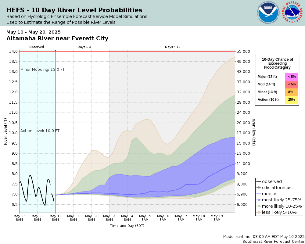
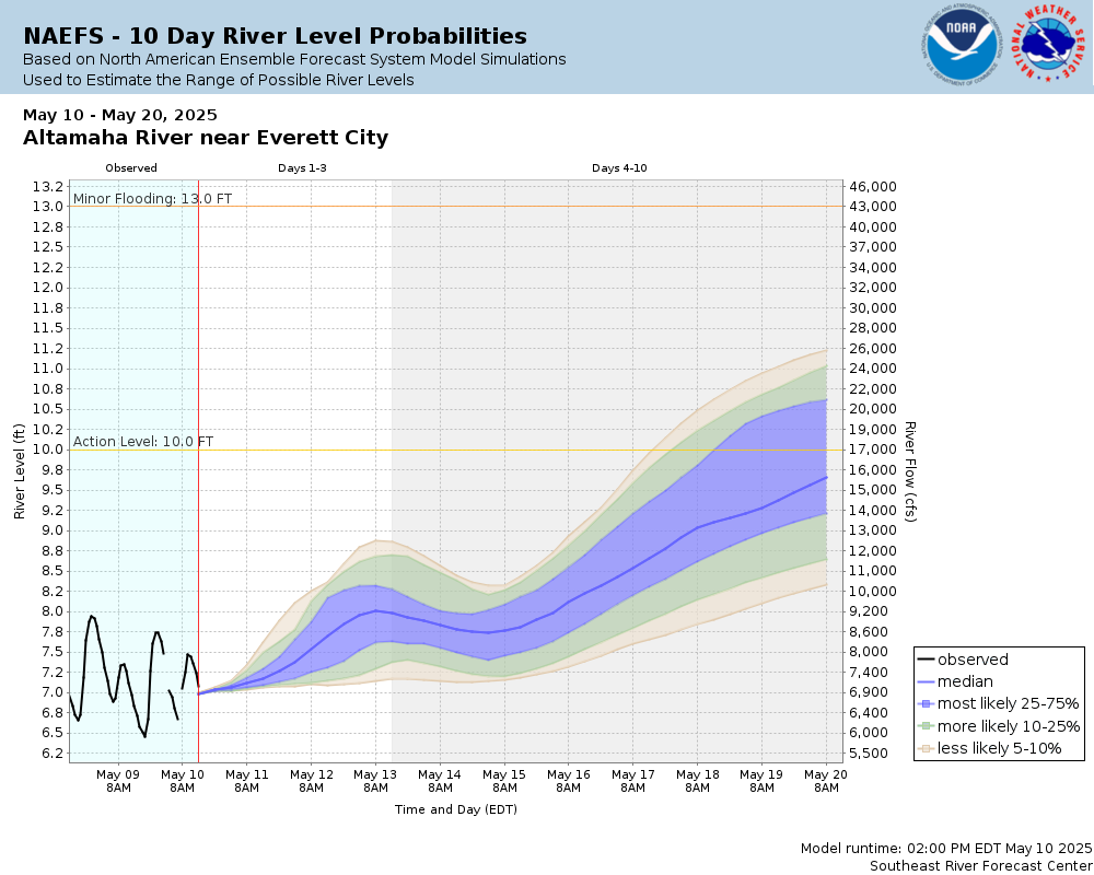
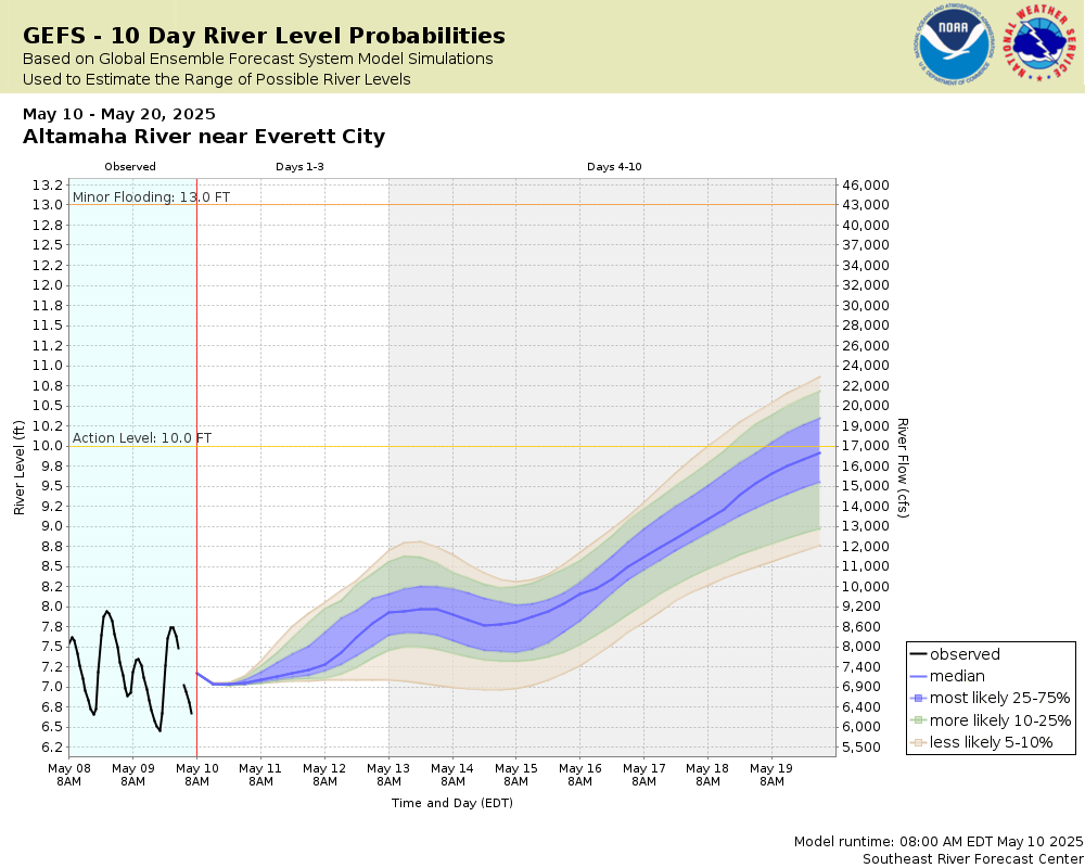
Altamaha River near Everett City
Future / Actual / Minor
OWP 2.0 WWA Modal Title
01/11/2021, 10:04 PM UTC through 01/11/2021, 10:04 PM UTC
Sender
Sent
- Downstream gauge unavailableWarning: no valid ratings curve available. Transformations to and from FEET/CFS/KCFS will not happen.
Traces and Thresholds Click to turn on/off display
Observed (OBS) 03/16/2025 11:15 AM EDTLow Threshold: 3.5 ftCATEGORY STAGE 
Major Flooding 17 ft Moderate Flooding 14 ft Minor Flooding 13 ft Action 10 ft Reliability of the Forecast:
NOTE: Forecasts are issued as needed during times of high water, but are not routinely available.
River forecasts for this location take into account past precipitation and the precipitation amounts expected approximately 48 hours into the future from the forecast issuance time.
National Water Model Hydrograph
Official NWS streamflow forecasts are produced by NWS hydrologic forecasters for river gauge locations using hydrologic models which are calibrated to that location. This process considers additional guidance and information, including local expertise and experience, to produce the best forecast possible. The NWM output provides supplemental guidance to NWS forecasters and should not be considered an official NWS river forecast.
Flood Impacts
- 17 - In Glynn County, major flooding occurs along all roads to the southwest of the Altamaha Regional Park to near U.S. Highway 341. Water affects homes along Pennick and Old Jesup Roads as well as homes in Altamaha Regional Park. In McIntosh County, significant flooding occurs in Barrington Park.
- 16.5 - In McIntosh County, water will approach a few elevated homes on Barrington Ferry Road, possibly restricting access.
- 15 - In Glynn County, the majority of Altamaha Regional Park becomes inundated, including water flowing across sections of Altamaha Park Road and Pennick Road. The Altamaha Regional Park is subject to closure at this level. Homes in the vicinity of the park are cut off by flood waters at this level, but elevated structures are not flooded. In McIntosh County, much of Barrington Park is underwater. Plum Orchard Road begins to flood.
Gauge Info
| Coordinates | 31.4269, -81.6056 |
| RFC | SERFC |
| State | GA |
| WFO | JAX |
| County | Glynn |
| Data Provider(s) | |
| US Geological Survey | USGS--Water Resources of the United States |
| USGS | 02226160 |
Gauge Location
Recent Crests
| 1. | 13.16 ft | on 10-08-2024 |
| 2. | 14.51 ft | on 08-10-2024 |
| 3. | 14.61 ft | on 03-22-2024 |
| 4. | 14.50 ft | on 02-26-2024 |
| 5. | 13.97 ft | on 04-10-2023 |
Recent Crests
| 1. | 13.16 ft | on 10-08-2024 |
| 2. | 14.51 ft | on 08-10-2024 |
| 3. | 14.61 ft | on 03-22-2024 |
| 4. | 14.50 ft | on 02-26-2024 |
| 5. | 13.97 ft | on 04-10-2023 |
| 6. | 13.78 ft | on 04-21-2022 |
| 7. | 13.31 ft | on 10-21-2021 |
| 8. | 13.53 ft | on 03-03-2021 |
| 9. | 14.53 ft | on 02-24-2021 |
| 10. | 14.64 ft | on 05-02-2020 |
| 11. | 16.68 ft | on 03-11-2020 |
| 12. | 16.43 ft | on 03-03-2020 |
| 13. | 15.17 ft | on 02-21-2020 |
| 14. | 14.19 ft | on 01-17-2019 |
| 15. | 13.06 ft | on 01-04-2019 |
| 16. | 13.34 ft | on 12-26-2018 |
| 17. | 13.06 ft | on 04-15-2016 |
| 18. | 13.90 ft | on 02-10-2016 |
| 19. | 16.61 ft | on 01-11-2016 |
| 20. | 13.37 ft | on 05-05-2015 |
| 21. | 12.88 ft | on 03-08-2015 |
| 22. | 13.49 ft | on 04-26-2014 |
| 23. | 12.56 ft | on 01-12-2014 |
| 24. | 13.49 ft | on 08-27-2013 |
| 25. | 13.22 ft | on 07-23-2013 |
| 26. | 14.57 ft | on 03-04-2013 |
| 27. | 9.15 ft | on 03-11-2012 |
| 28. | 11.55 ft | on 02-20-2011 |
| 29. | 12.80 ft | on 03-26-2010 |
| 30. | 15.10 ft | on 02-09-2010 |
| 31. | 15.43 ft | on 12-24-2009 |
| 32. | 13.14 ft | on 11-28-2009 |
| 33. | 16.76 ft | on 04-13-2009 |
| 34. | 12.21 ft | on 03-01-2008 |
Historic Crests
| 1. | 16.76 ft | on 04-13-2009 |
| 2. | 16.68 ft | on 03-11-2020 |
| 3. | 16.61 ft | on 01-11-2016 |
| 4. | 16.43 ft | on 03-03-2020 |
| 5. | 15.43 ft | on 12-24-2009 |
Historic Crests
| 1. | 16.76 ft | on 04-13-2009 |
| 2. | 16.68 ft | on 03-11-2020 |
| 3. | 16.61 ft | on 01-11-2016 |
| 4. | 16.43 ft | on 03-03-2020 |
| 5. | 15.43 ft | on 12-24-2009 |
| 6. | 15.17 ft | on 02-21-2020 |
| 7. | 15.10 ft | on 02-09-2010 |
| 8. | 14.64 ft | on 05-02-2020 |
| 9. | 14.61 ft | on 03-22-2024 |
| 10. | 14.57 ft | on 03-04-2013 |
| 11. | 14.53 ft | on 02-24-2021 |
| 12. | 14.51 ft | on 08-10-2024 |
| 13. | 14.50 ft | on 02-26-2024 |
| 14. | 14.19 ft | on 01-17-2019 |
| 15. | 13.97 ft | on 04-10-2023 |
| 16. | 13.90 ft | on 02-10-2016 |
| 17. | 13.78 ft | on 04-21-2022 |
| 18. | 13.53 ft | on 03-03-2021 |
| 19. | 13.49 ft | on 08-27-2013 |
| 20. | 13.49 ft | on 04-26-2014 |
| 21. | 13.37 ft | on 05-05-2015 |
| 22. | 13.34 ft | on 12-26-2018 |
| 23. | 13.31 ft | on 10-21-2021 |
| 24. | 13.22 ft | on 07-23-2013 |
| 25. | 13.16 ft | on 10-08-2024 |
| 26. | 13.14 ft | on 11-28-2009 |
| 27. | 13.06 ft | on 01-04-2019 |
| 28. | 13.06 ft | on 04-15-2016 |
| 29. | 12.88 ft | on 03-08-2015 |
| 30. | 12.80 ft | on 03-26-2010 |
| 31. | 12.56 ft | on 01-12-2014 |
| 32. | 12.21 ft | on 03-01-2008 |
| 33. | 11.55 ft | on 02-20-2011 |
| 34. | 9.15 ft | on 03-11-2012 |
Vertical Datum Table
| type | NGVD29 |
|---|---|
| major Flooding | 13.13 ft |
| moderate Flooding | 10.13 ft |
| minor Flooding | 9.13 ft |
| action | 6.13 ft |
| Latest Value | 5.23 ft |
| Gauge Zero | -3.87 ft |
Gauge Photos
No Images Found


Unique Local Info
Collaborative Agencies
The National Weather Service prepares its forecasts and other services in collaboration with agencies like the US Geological Survey, US Bureau of Reclamation, US Army Corps of Engineers, Natural Resource Conservation Service, National Park Service, ALERT Users Group, Bureau of Indian Affairs, and many state and local emergency managers across the country. For details, please click here.