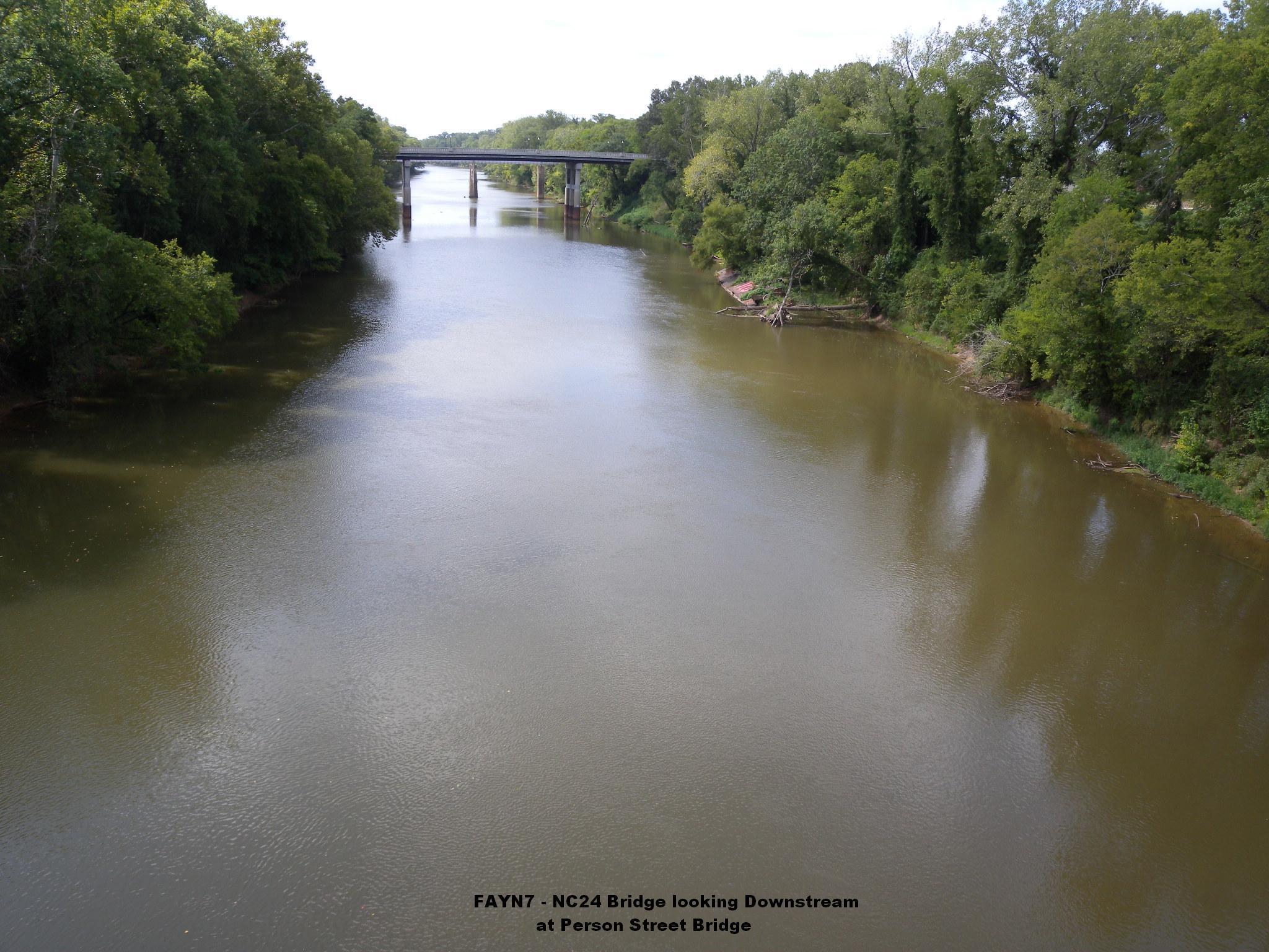
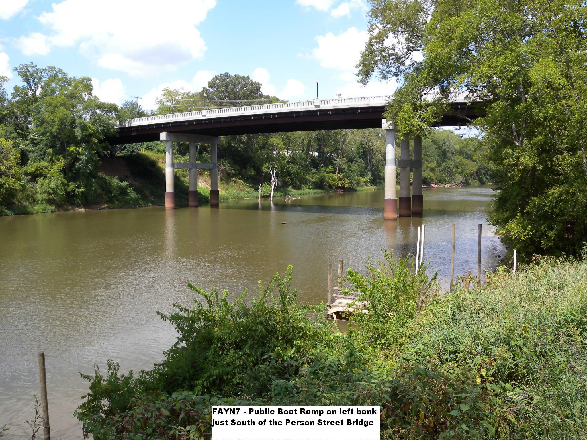
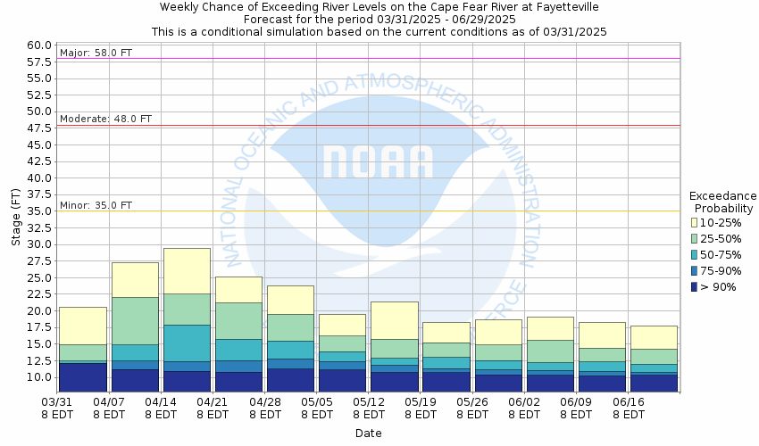
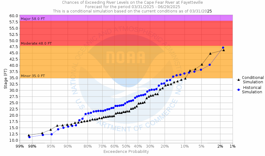
Cape Fear River at Fayetteville
Future / Actual / Minor
OWP 2.0 WWA Modal Title
01/11/2021, 10:04 PM UTC through 01/11/2021, 10:04 PM UTC
Sender
Sent
- Warning: no valid ratings curve available. Transformations to and from FEET/CFS/KCFS will not happen.
Traces and Thresholds Click to turn on/off display
Observed (OBS) 06/20/2025 10:00 AM EDTOfficial Forecast (FCST) 06/20/2025 9:01 AM EDTRecord: 68.9 ftCATEGORY STAGE 
Major Flooding 58 ft Moderate Flooding 48 ft Minor Flooding 35 ft Action 35 ft Reliability of the Forecast:
NOTE: Forecasts are issued routinely year-round.
National Water Model Hydrograph
Official NWS streamflow forecasts are produced by NWS hydrologic forecasters for river gauge locations using hydrologic models which are calibrated to that location. This process considers additional guidance and information, including local expertise and experience, to produce the best forecast possible. The NWM output provides supplemental guidance to NWS forecasters and should not be considered an official NWS river forecast.
Flood Impacts
- 72 - The river will spread to a width of up to 2 miles, with several thousand structures threatened.
- 69 - The city of Fayetteville begins to flood and up to one hundred and fifty homes would be threatened. At this stage the river widens to a mile or more in some places.
- 64 - Several thousand acres of land and hundreds of structures on both sides of the river will be flooded. Water reaches the under-clearance of the downstream railroad trestle. Downstream about 2 miles, the river will spread to a width of approximately 1 mile.
Gauge Info
| Coordinates | 35.0472, -78.8581 |
| RFC | SERFC |
| State | NC |
| WFO | RAH |
| County | Cumberland |
| Data Provider(s) | |
| US Geological Survey | USGS--Water Resources of the United States |
| USGS | 02104000 |
Gauge Location
Recent Crests
| 1. | 42.94 ft | on 08-10-2024 | (P) |
| 2. | 35.32 ft | on 02-17-2021 | (P) |
| 3. | 36.05 ft | on 01-04-2021 | (P) |
| 4. | 41.68 ft | on 02-08-2020 | |
| 5. | 43.49 ft | on 11-16-2018 |
Recent Crests
| 1. | 42.94 ft | on 08-10-2024 | (P) |
| 2. | 35.32 ft | on 02-17-2021 | (P) |
| 3. | 36.05 ft | on 01-04-2021 | (P) |
| 4. | 41.68 ft | on 02-08-2020 | |
| 5. | 43.49 ft | on 11-16-2018 | |
| 6. | 24.60 ft | on 10-13-2018 | |
| 7. | 61.58 ft | on 09-19-2018 | |
| 8. | 58.94 ft | on 10-10-2016 | |
| 9. | 37.98 ft | on 02-09-2010 | |
| 10. | 43.01 ft | on 04-12-2003 | |
| 11. | 38.38 ft | on 09-17-1999 | |
| 12. | 46.17 ft | on 09-07-1996 | |
| 13. | 38.30 ft | on 02-19-1995 | |
| 14. | 35.10 ft | on 03-05-1994 | |
| 15. | 45.30 ft | on 07-17-1975 | |
| 16. | 44.20 ft | on 07-29-1965 | |
| 17. | 47.10 ft | on 01-24-1954 | |
| 18. | 47.00 ft | on 09-02-1952 | |
| 19. | 48.30 ft | on 09-24-1945 | |
| 20. | 68.90 ft | on 09-21-1945 | 1 |
| 21. | 55.40 ft | on 04-08-1936 | |
| 22. | 65.30 ft | on 10-04-1929 | |
| 23. | 64.70 ft | on 09-22-1928 | |
| 24. | 55.50 ft | on 09-08-1928 | |
| 25. | 52.00 ft | on 07-24-1919 | |
| 26. | 68.00 ft | on 08-29-1908 | 1 |
| 27. | 58.50 ft | on 05-24-1901 | |
| 28. | 58.00 ft | on 01-12-1895 | |
| 29. | 52.30 ft | on 03-01-1888 |
Historic Crests
| 1. | 68.90 ft | on 09-21-1945 | 1 |
| 2. | 68.00 ft | on 08-29-1908 | 1 |
| 3. | 65.30 ft | on 10-04-1929 | |
| 4. | 64.70 ft | on 09-22-1928 | |
| 5. | 61.58 ft | on 09-19-2018 |
Historic Crests
| 1. | 68.90 ft | on 09-21-1945 | 1 |
| 2. | 68.00 ft | on 08-29-1908 | 1 |
| 3. | 65.30 ft | on 10-04-1929 | |
| 4. | 64.70 ft | on 09-22-1928 | |
| 5. | 61.58 ft | on 09-19-2018 | |
| 6. | 58.94 ft | on 10-10-2016 | |
| 7. | 58.50 ft | on 05-24-1901 | |
| 8. | 58.00 ft | on 01-12-1895 | |
| 9. | 55.50 ft | on 09-08-1928 | |
| 10. | 55.40 ft | on 04-08-1936 | |
| 11. | 52.30 ft | on 03-01-1888 | |
| 12. | 52.00 ft | on 07-24-1919 | |
| 13. | 48.30 ft | on 09-24-1945 | |
| 14. | 47.10 ft | on 01-24-1954 | |
| 15. | 47.00 ft | on 09-02-1952 | |
| 16. | 46.17 ft | on 09-07-1996 | |
| 17. | 45.30 ft | on 07-17-1975 | |
| 18. | 44.20 ft | on 07-29-1965 | |
| 19. | 43.49 ft | on 11-16-2018 | |
| 20. | 43.01 ft | on 04-12-2003 | |
| 21. | 42.94 ft | on 08-10-2024 | (P) |
| 22. | 41.68 ft | on 02-08-2020 | |
| 23. | 38.38 ft | on 09-17-1999 | |
| 24. | 38.30 ft | on 02-19-1995 | |
| 25. | 37.98 ft | on 02-09-2010 | |
| 26. | 36.05 ft | on 01-04-2021 | (P) |
| 27. | 35.32 ft | on 02-17-2021 | (P) |
| 28. | 35.10 ft | on 03-05-1994 | |
| 29. | 24.60 ft | on 10-13-2018 |
Vertical Datum Table
| type | NAVD88 |
|---|---|
| major Flooding | 77.64 ft |
| moderate Flooding | 67.64 ft |
| minor Flooding | 54.64 ft |
| action | 54.64 ft |
| Latest Value | 35.54 ft |
| Gauge Zero | 19.64 ft |


Unique Local Info
|
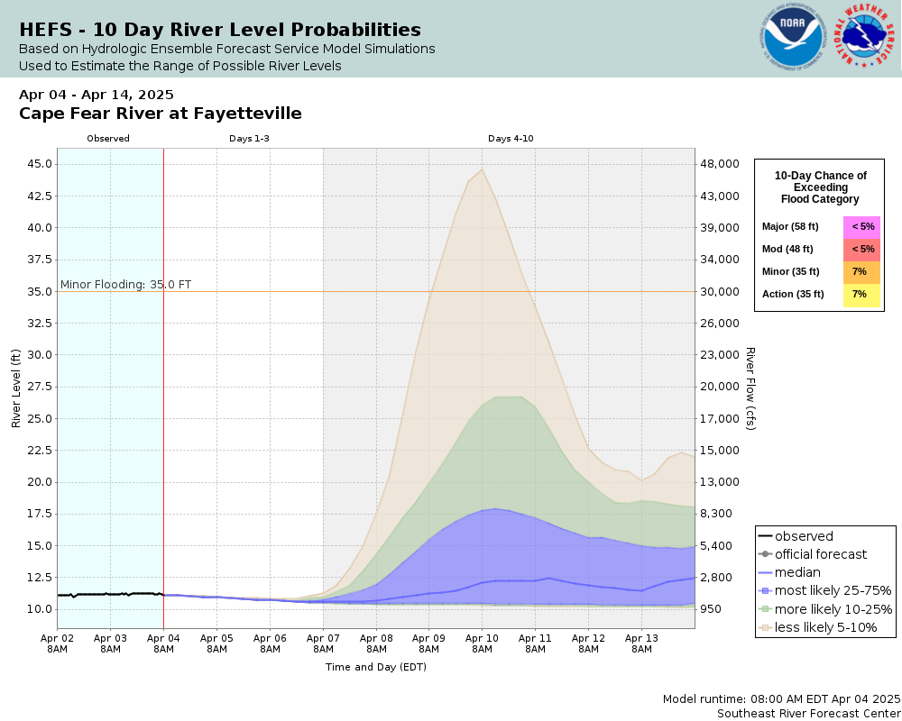
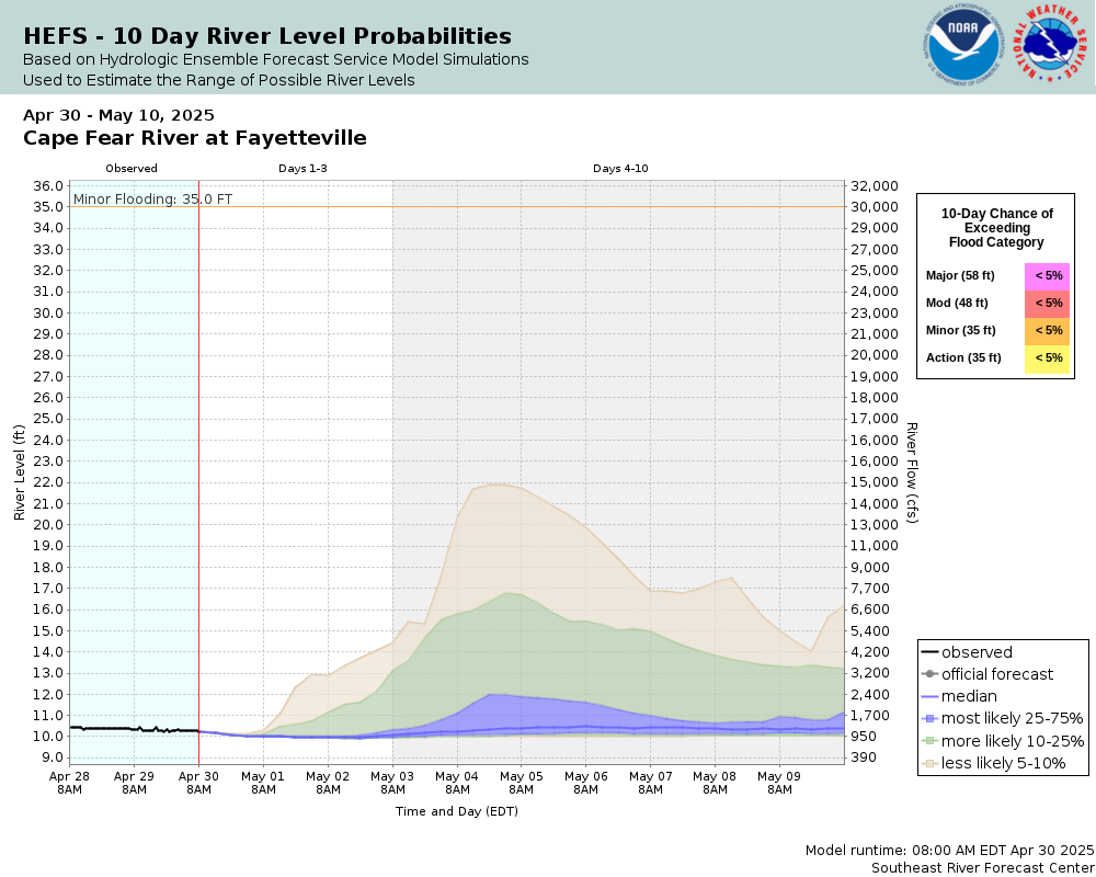
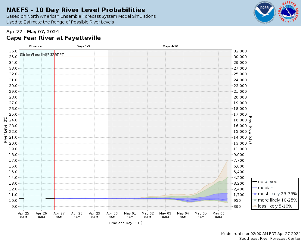
Potential River Levels Used to Estimate the Chance of Flooding and the Range of Possible River Levels |
||
| 10 day (HEFS) | 10 Day (NAEFS) | 10 Day (GEFS) |
 |
 |
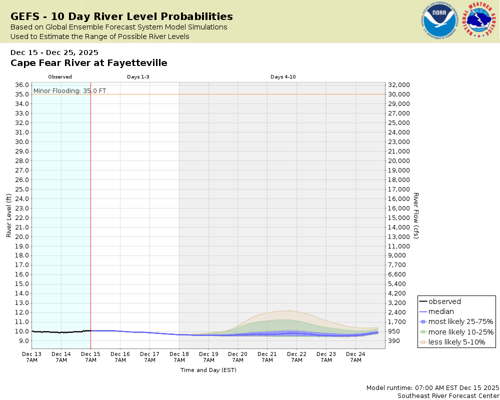 |
Note: Use the official hydrograph at the top of this web page for river levels within the next 72 Hours.
Collaborative Agencies
The National Weather Service prepares its forecasts and other services in collaboration with agencies like the US Geological Survey, US Bureau of Reclamation, US Army Corps of Engineers, Natural Resource Conservation Service, National Park Service, ALERT Users Group, Bureau of Indian Affairs, and many state and local emergency managers across the country. For details, please click here.