Kentucky River at Frankfort Lock
Future / Actual / Minor
OWP 2.0 WWA Modal Title
01/11/2021, 10:04 PM UTC through 01/11/2021, 10:04 PM UTC
Sender
Sent
- Warning: no valid ratings curve available. Transformations to and from FEET/CFS/KCFS will not happen.
Traces and Thresholds Click to turn on/off display
Observed (OBS) 06/30/2025 7:30 AM EDTOfficial Forecast (FCST) 06/29/2025 10:05 AM EDTRecord: 48.5 ftCATEGORY STAGE 
Major Flooding 40 ft Moderate Flooding 35 ft Minor Flooding 31 ft Action 29 ft Reliability of the Forecast:
NOTE: Forecasts are issued routinely year-round.
River forecasts for this location take into account past precipitation and the precipitation amounts expected approximately 48 hours into the future from the forecast issuance time.
National Water Model Hydrograph
Official NWS streamflow forecasts are produced by NWS hydrologic forecasters for river gauge locations using hydrologic models which are calibrated to that location. This process considers additional guidance and information, including local expertise and experience, to produce the best forecast possible. The NWM output provides supplemental guidance to NWS forecasters and should not be considered an official NWS river forecast.
Flood Impacts
- 51.5 - Water reaches the top of protection in South Frankfort.
- 51 - Water reaches the top of protection in North Frankfort.
- 48 - Areas outside of floodwall are covered. Many county roads are closed.
Gauge Info
| Coordinates | 38.2017, -84.8817 |
| RFC | OHRFC |
| State | KY |
| WFO | LMK |
| County | Franklin |
| Data Provider(s) | |
| US Geological Survey | USGS--Water Resources of the United States |
| USGS | 03287500 |
Gauge Location
Recent Crests
| 1. | 48.39 ft | on 04-07-2025 | (P) |
| 2. | 39.34 ft | on 02-17-2025 | (P) |
| 3. | 40.16 ft | on 03-05-2021 | |
| 4. | 32.33 ft | on 02-25-2019 | |
| 5. | 36.15 ft | on 04-05-2015 |
Recent Crests
| 1. | 48.39 ft | on 04-07-2025 | (P) |
| 2. | 39.34 ft | on 02-17-2025 | (P) |
| 3. | 40.16 ft | on 03-05-2021 | |
| 4. | 32.33 ft | on 02-25-2019 | |
| 5. | 36.15 ft | on 04-05-2015 | |
| 6. | 42.84 ft | on 05-05-2010 | |
| 7. | 34.41 ft | on 06-01-2004 | |
| 8. | 35.16 ft | on 02-20-2003 | |
| 9. | 35.81 ft | on 03-22-2002 | |
| 10. | 45.22 ft | on 03-03-1997 | |
| 11. | 33.75 ft | on 05-20-1995 | |
| 12. | 34.63 ft | on 03-11-1994 | |
| 13. | 33.72 ft | on 12-31-1990 | |
| 14. | 44.17 ft | on 02-16-1989 | |
| 15. | 38.99 ft | on 05-09-1984 | |
| 16. | 48.47 ft | on 12-10-1978 | |
| 17. | 35.16 ft | on 03-30-1975 | |
| 18. | 34.46 ft | on 01-14-1974 | |
| 19. | 42.25 ft | on 04-16-1972 | |
| 20. | 34.45 ft | on 02-27-1972 | |
| 21. | 30.27 ft | on 03-10-1967 | |
| 22. | 38.71 ft | on 03-10-1964 | |
| 23. | 30.65 ft | on 03-16-1963 | |
| 24. | 40.73 ft | on 03-01-1962 | |
| 25. | 30.85 ft | on 05-09-1961 | |
| 26. | 35.46 ft | on 02-03-1957 | |
| 27. | 31.80 ft | on 02-19-1956 | |
| 28. | 37.10 ft | on 03-06-1955 | |
| 29. | 33.21 ft | on 03-26-1952 | |
| 30. | 37.84 ft | on 02-02-1950 | |
| 31. | 31.38 ft | on 01-07-1950 | |
| 32. | 35.27 ft | on 04-15-1948 | |
| 33. | 35.61 ft | on 02-17-1948 | |
| 34. | 30.13 ft | on 01-12-1946 | |
| 35. | 35.38 ft | on 03-07-1945 | |
| 36. | 33.76 ft | on 12-31-1943 | |
| 37. | 32.00 ft | on 03-20-1943 | |
| 38. | 35.60 ft | on 02-07-1939 | |
| 39. | 47.46 ft | on 01-25-1937 | |
| 40. | 33.50 ft | on 03-13-1935 | |
| 41. | 30.30 ft | on 02-02-1932 | |
| 42. | 30.50 ft | on 03-27-1929 | |
| 43. | 31.90 ft | on 01-22-1927 | |
| 44. | 34.90 ft | on 12-26-1926 | |
| 45. | 31.40 ft | on 12-09-1924 | |
| 46. | 35.10 ft | on 01-04-1924 | |
| 47. | 33.50 ft | on 01-10-1920 | |
| 48. | 32.60 ft | on 01-02-1919 | |
| 49. | 31.50 ft | on 01-31-1918 | |
| 50. | 32.80 ft | on 01-22-1917 | |
| 51. | 36.20 ft | on 12-19-1915 | |
| 52. | 38.20 ft | on 03-27-1913 | |
| 53. | 35.80 ft | on 01-11-1913 | |
| 54. | 34.30 ft | on 02-24-1909 | |
| 55. | 30.30 ft | on 04-02-1908 | |
| 56. | 33.20 ft | on 02-24-1897 | |
| 57. | 42.80 ft | on 02-01-1883 | |
| 58. | 37.00 ft | on 02-01-1880 | |
| 59. | 36.50 ft | on 03-01-1854 | |
| 60. | 37.00 ft | on 01-01-1847 | |
| 61. | 37.50 ft | on 01-01-1817 |
Historic Crests
| 1. | 48.47 ft | on 12-10-1978 | |
| 2. | 48.39 ft | on 04-07-2025 | (P) |
| 3. | 47.46 ft | on 01-25-1937 | |
| 4. | 45.22 ft | on 03-03-1997 | |
| 5. | 44.17 ft | on 02-16-1989 |
Historic Crests
| 1. | 48.47 ft | on 12-10-1978 | |
| 2. | 48.39 ft | on 04-07-2025 | (P) |
| 3. | 47.46 ft | on 01-25-1937 | |
| 4. | 45.22 ft | on 03-03-1997 | |
| 5. | 44.17 ft | on 02-16-1989 | |
| 6. | 42.84 ft | on 05-05-2010 | |
| 7. | 42.80 ft | on 02-01-1883 | |
| 8. | 42.25 ft | on 04-16-1972 | |
| 9. | 40.73 ft | on 03-01-1962 | |
| 10. | 40.16 ft | on 03-05-2021 | |
| 11. | 39.34 ft | on 02-17-2025 | (P) |
| 12. | 38.99 ft | on 05-09-1984 | |
| 13. | 38.71 ft | on 03-10-1964 | |
| 14. | 38.20 ft | on 03-27-1913 | |
| 15. | 37.84 ft | on 02-02-1950 | |
| 16. | 37.50 ft | on 01-01-1817 | |
| 17. | 37.10 ft | on 03-06-1955 | |
| 18. | 37.00 ft | on 02-01-1880 | |
| 19. | 37.00 ft | on 01-01-1847 | |
| 20. | 36.50 ft | on 03-01-1854 | |
| 21. | 36.20 ft | on 12-19-1915 | |
| 22. | 36.15 ft | on 04-05-2015 | |
| 23. | 35.81 ft | on 03-22-2002 | |
| 24. | 35.80 ft | on 01-11-1913 | |
| 25. | 35.61 ft | on 02-17-1948 | |
| 26. | 35.60 ft | on 02-07-1939 | |
| 27. | 35.46 ft | on 02-03-1957 | |
| 28. | 35.38 ft | on 03-07-1945 | |
| 29. | 35.27 ft | on 04-15-1948 | |
| 30. | 35.16 ft | on 03-30-1975 | |
| 31. | 35.16 ft | on 02-20-2003 | |
| 32. | 35.10 ft | on 01-04-1924 | |
| 33. | 34.90 ft | on 12-26-1926 | |
| 34. | 34.63 ft | on 03-11-1994 | |
| 35. | 34.46 ft | on 01-14-1974 | |
| 36. | 34.45 ft | on 02-27-1972 | |
| 37. | 34.41 ft | on 06-01-2004 | |
| 38. | 34.30 ft | on 02-24-1909 | |
| 39. | 33.76 ft | on 12-31-1943 | |
| 40. | 33.75 ft | on 05-20-1995 | |
| 41. | 33.72 ft | on 12-31-1990 | |
| 42. | 33.50 ft | on 01-10-1920 | |
| 43. | 33.50 ft | on 03-13-1935 | |
| 44. | 33.21 ft | on 03-26-1952 | |
| 45. | 33.20 ft | on 02-24-1897 | |
| 46. | 32.80 ft | on 01-22-1917 | |
| 47. | 32.60 ft | on 01-02-1919 | |
| 48. | 32.33 ft | on 02-25-2019 | |
| 49. | 32.00 ft | on 03-20-1943 | |
| 50. | 31.90 ft | on 01-22-1927 | |
| 51. | 31.80 ft | on 02-19-1956 | |
| 52. | 31.50 ft | on 01-31-1918 | |
| 53. | 31.40 ft | on 12-09-1924 | |
| 54. | 31.38 ft | on 01-07-1950 | |
| 55. | 30.85 ft | on 05-09-1961 | |
| 56. | 30.65 ft | on 03-16-1963 | |
| 57. | 30.50 ft | on 03-27-1929 | |
| 58. | 30.30 ft | on 04-02-1908 | |
| 59. | 30.30 ft | on 02-02-1932 | |
| 60. | 30.27 ft | on 03-10-1967 | |
| 61. | 30.13 ft | on 01-12-1946 |
Vertical Datum Table
| type | NGVD29 |
|---|---|
| major Flooding | 502.10 ft |
| moderate Flooding | 497.10 ft |
| minor Flooding | 493.10 ft |
| action | 491.10 ft |
| Latest Value | 470.07 ft |
| Gauge Zero | 462.10 ft |


Unique Local Info
|
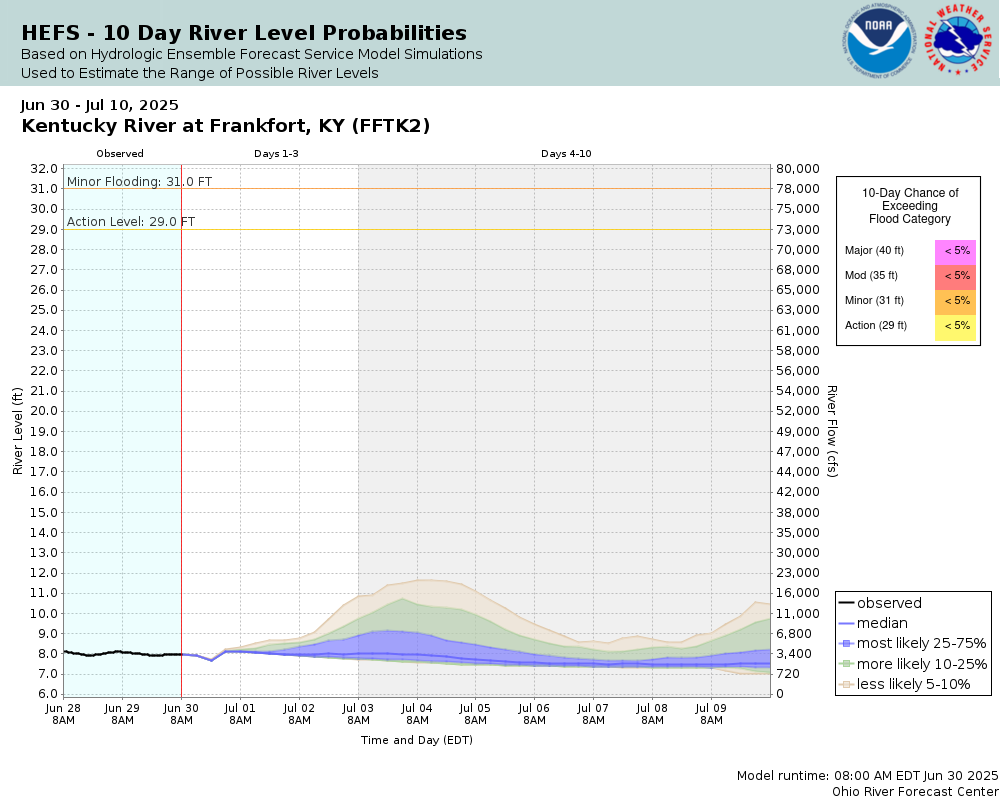
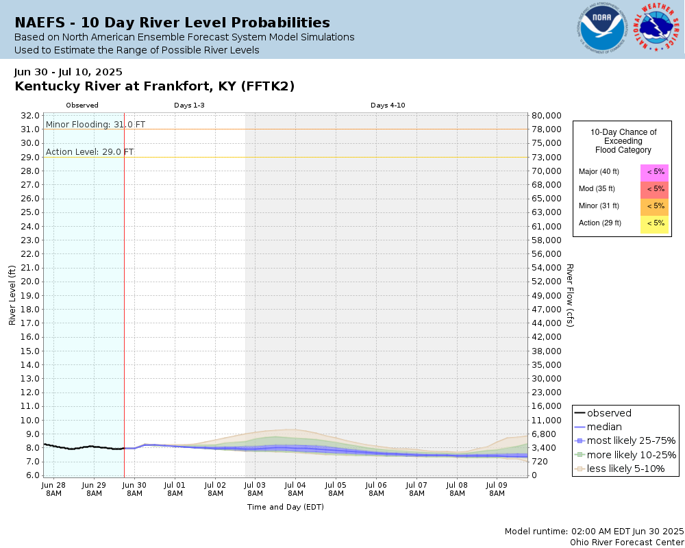
Potential River Levels Used to Estimate the Chance of Flooding and the Range of Possible River Levels |
||
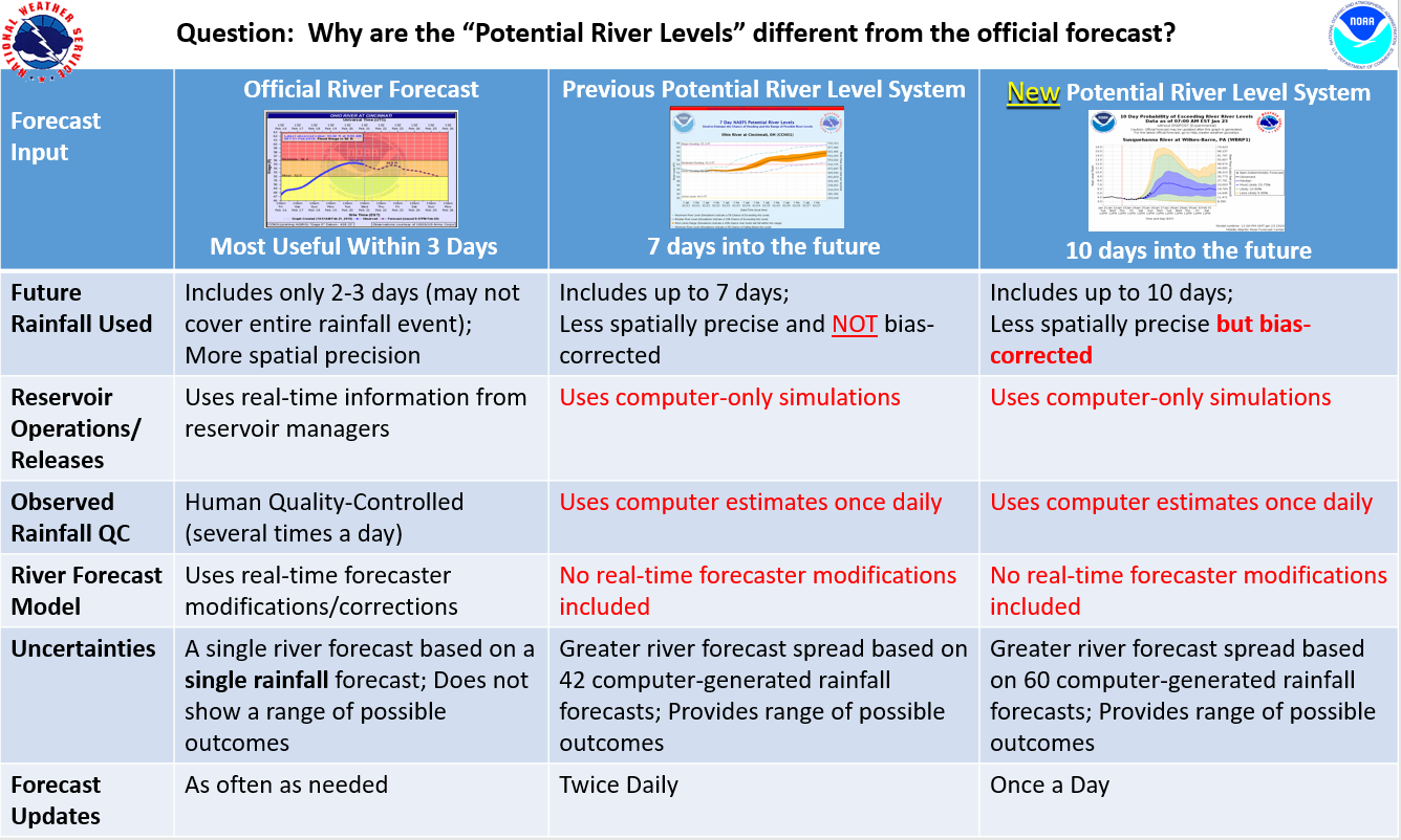
| 10 Day (HEFS) | 10 Day (NAEFS) | River Forecast VS. River Potential |
 |
 |
 |
Note: Use the official hydrograph at the top of this web page for river levels within the next 72 hours.
Click individual graphics to enlarge.
USGS Average StreamflowUSGS Flood Inundation Mapper
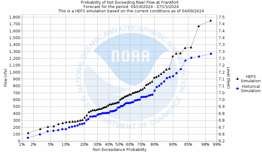
How low could the river get?
Collaborative Agencies
The National Weather Service prepares its forecasts and other services in collaboration with agencies like the US Geological Survey, US Bureau of Reclamation, US Army Corps of Engineers, Natural Resource Conservation Service, National Park Service, ALERT Users Group, Bureau of Indian Affairs, and many state and local emergency managers across the country. For details, please click here.
Resources
Hydrologic Resource Links
- River Forecast Centers
- NEW!! Mobile Friendly River Forecasts for the Entire Ohio River
- Text Products
- Past Precipitation
- Forecast Precipitation
- Flash Flood Guidance
- Hydrologic Program Overview
- Interactive Precipitation Map
- Interactive Snowfall Map
- Ohio Basin Water Resources Outlook
- KY Precipitation Frequencies
- IN Precipitation Frequencies
- Inundation Mapping Locations
- 1-7 Day Ensemble River Forecasts
- Ohio River Flows and Velocities
- USGS Waterwatch Toolkit