Oatka Creek at Garbutt
Future / Actual / Minor
OWP 2.0 WWA Modal Title
01/11/2021, 10:04 PM UTC through 01/11/2021, 10:04 PM UTC
Sender
Sent
- Upstream gauge unavailableDownstream gauge unavailableWarning: no valid ratings curve available. Transformations to and from FEET/CFS/KCFS will not happen.
Traces and Thresholds Click to turn on/off display
Observed (OBS) 06/22/2025 11:00 PM EDTOfficial Forecast (FCST) 06/22/2025 12:02 PM EDTCATEGORY STAGE 
Major Flooding 8 ft Moderate Flooding 7 ft Minor Flooding 6 ft Action 5 ft Reliability of the Forecast:
NOTE: Forecasts are issued routinely year-round.
National Water Model Hydrograph
Official NWS streamflow forecasts are produced by NWS hydrologic forecasters for river gauge locations using hydrologic models which are calibrated to that location. This process considers additional guidance and information, including local expertise and experience, to produce the best forecast possible. The NWM output provides supplemental guidance to NWS forecasters and should not be considered an official NWS river forecast.
Flood Impacts
- 8 - Major flood, extensive residential flooding along creek. Major damages in Mumford, Wheatland, Scottsville, and Garbutt. Roadways closed. Widespread agricultural flooding near the creek in Monroe and Genesee counties. Probable backwater effects from Genesee River.
- 7 - Moderate flood, widespread flooding of agricultural lands below LeRoy. Significant residential flooding along creek, especially in Mumford, Wheatland, and Scottsville. Roadway flooding begins. Some backwater effects possible from Genesee River near Scottsville.
- 6 - Flood stage, general flooding of agricultural land begins, some basement flooding in Scottsville and Garbutt.
Gauge Location
Recent Crests
| 1. | 6.35 ft | on 02-24-2022 |
| 2. | 6.24 ft | on 02-19-2022 |
| 3. | 6.69 ft | on 01-14-2018 |
| 4. | 7.19 ft | on 12-23-2013 |
| 5. | 6.70 ft | on 03-09-2009 |
Recent Crests
| 1. | 6.35 ft | on 02-24-2022 |
| 2. | 6.24 ft | on 02-19-2022 |
| 3. | 6.69 ft | on 01-14-2018 |
| 4. | 7.19 ft | on 12-23-2013 |
| 5. | 6.70 ft | on 03-09-2009 |
| 6. | 7.27 ft | on 02-13-2009 |
| 7. | 6.85 ft | on 12-29-2008 |
| 8. | 7.50 ft | on 03-15-2007 |
| 9. | 7.04 ft | on 04-04-2005 |
| 10. | 6.18 ft | on 09-09-2004 |
| 11. | 6.17 ft | on 03-19-2003 |
| 12. | 6.40 ft | on 04-09-2001 |
| 13. | 7.00 ft | on 07-10-1998 |
| 14. | 8.57 ft | on 01-09-1998 |
| 15. | 6.70 ft | on 04-14-1996 |
| 16. | 6.79 ft | on 01-20-1996 |
| 17. | 7.83 ft | on 03-31-1993 |
| 18. | 6.64 ft | on 04-23-1991 |
| 19. | 6.42 ft | on 04-06-1987 |
| 20. | 7.39 ft | on 02-25-1985 |
| 21. | 6.91 ft | on 04-06-1984 |
| 22. | 7.19 ft | on 03-06-1979 |
| 23. | 6.80 ft | on 03-23-1978 |
| 24. | 6.52 ft | on 09-27-1977 |
| 25. | 8.18 ft | on 03-05-1976 |
| 26. | 6.63 ft | on 03-18-1973 |
| 27. | 6.89 ft | on 06-24-1972 |
| 28. | 8.64 ft | on 03-31-1960 |
| 29. | 6.65 ft | on 01-24-1957 |
| 30. | 8.38 ft | on 03-08-1956 |
| 31. | 7.97 ft | on 03-02-1955 |
| 32. | 8.52 ft | on 03-29-1950 |
| 33. | 6.80 ft | on 04-06-1947 |
| 34. | 6.63 ft | on 01-07-1946 |
Historic Crests
| 1. | 8.64 ft | on 03-31-1960 |
| 2. | 8.57 ft | on 01-09-1998 |
| 3. | 8.52 ft | on 03-29-1950 |
| 4. | 8.38 ft | on 03-08-1956 |
| 5. | 8.18 ft | on 03-05-1976 |
Historic Crests
| 1. | 8.64 ft | on 03-31-1960 |
| 2. | 8.57 ft | on 01-09-1998 |
| 3. | 8.52 ft | on 03-29-1950 |
| 4. | 8.38 ft | on 03-08-1956 |
| 5. | 8.18 ft | on 03-05-1976 |
| 6. | 7.97 ft | on 03-02-1955 |
| 7. | 7.83 ft | on 03-31-1993 |
| 8. | 7.50 ft | on 03-15-2007 |
| 9. | 7.39 ft | on 02-25-1985 |
| 10. | 7.27 ft | on 02-13-2009 |
| 11. | 7.19 ft | on 03-06-1979 |
| 12. | 7.19 ft | on 12-23-2013 |
| 13. | 7.04 ft | on 04-04-2005 |
| 14. | 7.00 ft | on 07-10-1998 |
| 15. | 6.91 ft | on 04-06-1984 |
| 16. | 6.89 ft | on 06-24-1972 |
| 17. | 6.85 ft | on 12-29-2008 |
| 18. | 6.80 ft | on 04-06-1947 |
| 19. | 6.80 ft | on 03-23-1978 |
| 20. | 6.79 ft | on 01-20-1996 |
| 21. | 6.70 ft | on 03-09-2009 |
| 22. | 6.70 ft | on 04-14-1996 |
| 23. | 6.69 ft | on 01-14-2018 |
| 24. | 6.65 ft | on 01-24-1957 |
| 25. | 6.64 ft | on 04-23-1991 |
| 26. | 6.63 ft | on 01-07-1946 |
| 27. | 6.63 ft | on 03-18-1973 |
| 28. | 6.52 ft | on 09-27-1977 |
| 29. | 6.42 ft | on 04-06-1987 |
| 30. | 6.40 ft | on 04-09-2001 |
| 31. | 6.35 ft | on 02-24-2022 |
| 32. | 6.24 ft | on 02-19-2022 |
| 33. | 6.18 ft | on 09-09-2004 |
| 34. | 6.17 ft | on 03-19-2003 |
Vertical Datum Table
| type | NAVD88 |
|---|---|
| major Flooding | 568.15 ft |
| moderate Flooding | 567.15 ft |
| minor Flooding | 566.15 ft |
| action | 565.15 ft |
| Latest Value | 562.81 ft |
| Gauge Zero | 560.15 ft |
Gauge Photos
No Images Found


Unique Local Info
|
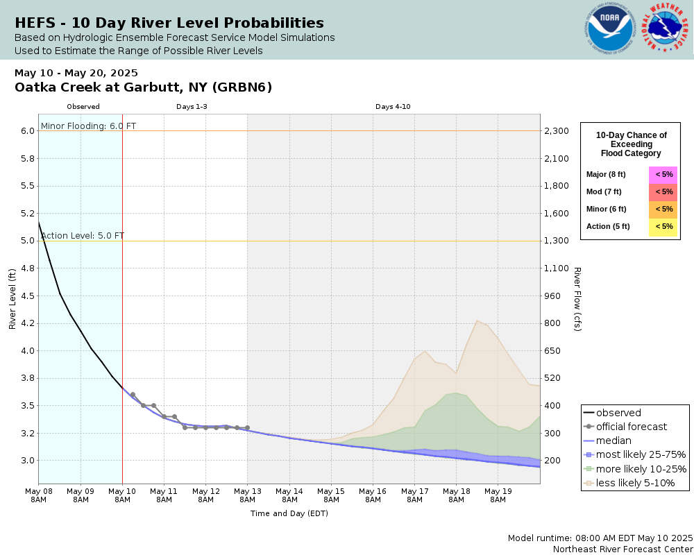
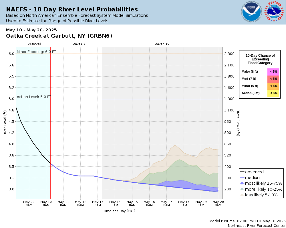
Potential River Levels Used to Estimate the Chance of Flooding and the Range of Possible River Levels |
||
| 10 Day (HEFS) | 7 Day (NAEFS) | 7 Day (GEFS) |
 |
 |
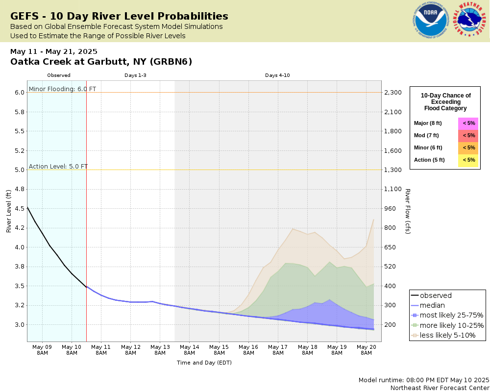 |
Note: Use the official hydrograph at the top of this web page for river levels within the next 48 hours.
See the Product Description Document link for more details on the interpretation of the 3,7 day graphics.
Click individual graphics to enlarge.
Observations Courtesy of the U.S. Geological SurveyCollaborative Agencies
The National Weather Service prepares its forecasts and other services in collaboration with agencies like the US Geological Survey, US Bureau of Reclamation, US Army Corps of Engineers, Natural Resource Conservation Service, National Park Service, ALERT Users Group, Bureau of Indian Affairs, and many state and local emergency managers across the country. For details, please click here.