Wabash River near Hutsonville
Future / Actual / Minor
OWP 2.0 WWA Modal Title
01/11/2021, 10:04 PM UTC through 01/11/2021, 10:04 PM UTC
Sender
Sent
- Warning: no valid ratings curve available. Transformations to and from FEET/CFS/KCFS will not happen.
Traces and Thresholds Click to turn on/off display
Official Forecast (FCST) 06/23/2025 7:47 PM CDTCATEGORY STAGE 
Major Flooding 28 ft Moderate Flooding 24 ft Minor Flooding 16 ft Action 12 ft Reliability of the Forecast: Based on current and forecast river, weather and reservoir conditions
NOTE: Forecasts are issued as needed during times of high water, but are not routinely available.
Data is unavailable, forecasts will continue to be displayed.
National Water Model Hydrograph
Official NWS streamflow forecasts are produced by NWS hydrologic forecasters for river gauge locations using hydrologic models which are calibrated to that location. This process considers additional guidance and information, including local expertise and experience, to produce the best forecast possible. The NWM output provides supplemental guidance to NWS forecasters and should not be considered an official NWS river forecast.
Flood Impacts
- 29 - Near record flooding. Widespread rural flooding is in progress. Evacuations are necessary behind Island Creek levee in Indiana and in the small Illinois towns of Hutsonville, York, and Darwin. Water is at the top of most agricultural levees. Many local river roads are extensively flooded. A 5 mile drive from Hutsonville to Grayville across the Wabash is now a 70 mile trip.
- 28.1 - At this level or slightly above SR 154 is closed to prevent shaking of nearby Island Creek Levee.
- 28 - Widespread rural flooding is in progress. All river roads are impassable, some by several feet of water. Evacuations are necessary in the small Illinois towns of Hutsonville, Darwin and eastern portion of York. Evacuations may also be necessary for those couple of families behind Island levee in Indiana. Water is at the top of most agricultural levees.
Gauge Location
Recent Crests
| 1. | 21.60 ft | on 01-26-2017 |
| 2. | 24.10 ft | on 06-26-2015 |
| 3. | 29.20 ft | on 04-25-2013 |
| 4. | 19.10 ft | on 01-17-2013 |
| 5. | 27.40 ft | on 05-02-2011 |
Recent Crests
| 1. | 21.60 ft | on 01-26-2017 |
| 2. | 24.10 ft | on 06-26-2015 |
| 3. | 29.20 ft | on 04-25-2013 |
| 4. | 19.10 ft | on 01-17-2013 |
| 5. | 27.40 ft | on 05-02-2011 |
| 6. | 22.80 ft | on 03-07-2011 |
| 7. | 23.50 ft | on 06-28-2010 |
| 8. | 22.90 ft | on 02-18-2009 |
| 9. | 28.40 ft | on 06-10-2008 |
| 10. | 21.70 ft | on 03-22-2008 |
| 11. | 26.50 ft | on 02-12-2008 |
| 12. | 23.10 ft | on 01-15-2008 |
| 13. | 24.40 ft | on 01-20-2007 |
| 14. | 20.20 ft | on 12-07-2006 |
| 15. | 29.45 ft | on 01-17-2005 |
| 16. | 25.20 ft | on 01-10-2005 |
| 17. | 24.50 ft | on 06-20-2004 |
| 18. | 22.30 ft | on 01-09-2004 |
| 19. | 25.90 ft | on 07-17-2003 |
| 20. | 25.30 ft | on 05-16-2002 |
| 21. | 21.20 ft | on 10-25-2001 |
| 22. | 18.00 ft | on 06-29-2000 |
| 23. | 24.50 ft | on 01-29-1999 |
| 24. | 25.80 ft | on 06-19-1998 |
| 25. | 20.80 ft | on 05-13-1998 |
| 26. | 20.50 ft | on 05-08-1998 |
| 27. | 20.00 ft | on 04-17-1998 |
| 28. | 21.50 ft | on 04-03-1998 |
| 29. | 21.80 ft | on 03-26-1998 |
| 30. | 16.70 ft | on 03-14-1998 |
| 31. | 17.10 ft | on 01-15-1998 |
| 32. | 20.10 ft | on 06-19-1997 |
| 33. | 18.50 ft | on 06-13-1997 |
| 34. | 16.50 ft | on 06-06-1997 |
| 35. | 16.10 ft | on 05-30-1997 |
| 36. | 13.00 ft | on 05-07-1997 |
| 37. | 22.30 ft | on 03-19-1997 |
| 38. | 24.40 ft | on 03-05-1997 |
| 39. | 16.90 ft | on 02-09-1997 |
| 40. | 17.00 ft | on 02-07-1997 |
| 41. | 16.60 ft | on 01-24-1997 |
| 42. | 13.70 ft | on 01-08-1997 |
| 43. | 16.20 ft | on 12-28-1996 |
| 44. | 14.30 ft | on 12-16-1996 |
| 45. | 17.00 ft | on 07-25-1996 |
| 46. | 16.60 ft | on 06-26-1996 |
| 47. | 19.10 ft | on 06-16-1996 |
| 48. | 21.70 ft | on 05-31-1996 |
| 49. | 22.80 ft | on 05-15-1996 |
| 50. | 16.00 ft | on 04-24-1996 |
| 51. | 15.10 ft | on 01-24-1996 |
| 52. | 14.00 ft | on 07-02-1995 |
| 53. | 19.60 ft | on 06-01-1995 |
| 54. | 20.10 ft | on 05-23-1995 |
| 55. | 15.90 ft | on 04-16-1995 |
| 56. | 19.30 ft | on 03-13-1995 |
| 57. | 14.60 ft | on 01-24-1995 |
| 58. | 12.20 ft | on 07-09-1994 |
| 59. | 11.80 ft | on 06-30-1994 |
| 60. | 12.30 ft | on 06-17-1994 |
| 61. | 16.20 ft | on 05-09-1994 |
| 62. | 18.10 ft | on 05-04-1994 |
| 63. | 26.50 ft | on 04-18-1994 |
| 64. | 15.20 ft | on 03-11-1994 |
| 65. | 19.90 ft | on 02-03-1994 |
| 66. | 19.00 ft | on 12-06-1993 |
| 67. | 22.40 ft | on 11-21-1993 |
| 68. | 18.60 ft | on 10-23-1993 |
| 69. | 16.00 ft | on 09-18-1993 |
| 70. | 15.20 ft | on 09-05-1993 |
| 71. | 15.00 ft | on 08-19-1993 |
| 72. | 18.20 ft | on 07-15-1993 |
| 73. | 21.00 ft | on 07-07-1993 |
| 74. | 20.20 ft | on 05-02-1993 |
| 75. | 20.30 ft | on 04-20-1993 |
| 76. | 20.00 ft | on 04-19-1993 |
| 77. | 18.40 ft | on 04-07-1993 |
| 78. | 18.60 ft | on 03-29-1993 |
| 79. | 20.90 ft | on 03-12-1993 |
| 80. | 21.90 ft | on 01-29-1993 |
| 81. | 25.10 ft | on 01-10-1993 |
| 82. | 15.50 ft | on 12-20-1992 |
| 83. | 24.30 ft | on 11-17-1992 |
| 84. | 20.20 ft | on 11-09-1992 |
| 85. | 28.00 ft | on 01-04-1991 |
| 86. | 19.20 ft | on 10-17-1990 |
| 87. | 23.00 ft | on 05-21-1990 |
| 88. | 23.70 ft | on 03-17-1990 |
| 89. | 20.20 ft | on 09-16-1989 |
| 90. | 21.40 ft | on 05-31-1989 |
| 91. | 19.00 ft | on 04-13-1988 |
| 92. | 18.20 ft | on 12-26-1987 |
| 93. | 16.40 ft | on 07-07-1987 |
| 94. | 19.80 ft | on 06-13-1986 |
| 95. | 23.10 ft | on 12-16-1985 |
| 96. | 22.90 ft | on 11-25-1985 |
| 97. | 28.70 ft | on 03-01-1985 |
| 98. | 22.70 ft | on 03-29-1984 |
| 99. | 24.80 ft | on 05-08-1983 |
| 100. | 25.60 ft | on 03-20-1982 |
| 101. | 24.10 ft | on 05-21-1981 |
| 102. | 21.90 ft | on 06-10-1980 |
| 103. | 20.60 ft | on 07-30-1979 |
| 104. | 25.00 ft | on 03-10-1979 |
| 105. | 25.00 ft | on 03-26-1978 |
| 106. | 21.50 ft | on 12-23-1977 |
| 107. | 18.50 ft | on 10-06-1977 |
| 108. | 23.40 ft | on 02-22-1976 |
| 109. | 21.90 ft | on 03-01-1975 |
| 110. | 25.40 ft | on 01-27-1974 |
| 111. | 22.80 ft | on 01-05-1973 |
| 112. | 23.10 ft | on 04-26-1972 |
| 113. | 21.00 ft | on 02-27-1971 |
| 114. | 23.90 ft | on 04-26-1970 |
| 115. | 26.20 ft | on 02-04-1969 |
| 116. | 26.20 ft | on 02-07-1968 |
| 117. | 23.30 ft | on 12-28-1967 |
| 118. | 18.90 ft | on 03-29-1967 |
| 119. | 24.20 ft | on 12-14-1966 |
| 120. | 20.80 ft | on 04-16-1965 |
| 121. | 25.30 ft | on 04-27-1964 |
| 122. | 23.80 ft | on 03-11-1963 |
| 123. | 22.60 ft | on 03-27-1962 |
| 124. | 24.50 ft | on 04-30-1961 |
| 125. | 20.90 ft | on 06-27-1960 |
| 126. | 27.90 ft | on 02-16-1959 |
| 127. | 29.30 ft | on 06-17-1958 |
| 128. | 25.30 ft | on 07-02-1957 |
| 129. | 19.50 ft | on 06-03-1956 |
| 130. | 17.10 ft | on 03-10-1955 |
| 131. | 12.30 ft | on 04-15-1954 |
| 132. | 19.90 ft | on 03-23-1953 |
| 133. | 21.20 ft | on 02-04-1952 |
| 134. | 24.70 ft | on 02-25-1951 |
| 135. | 28.40 ft | on 01-09-1950 |
| 136. | 24.50 ft | on 01-25-1949 |
| 137. | 24.40 ft | on 03-29-1948 |
| 138. | 22.00 ft | on 06-12-1947 |
| 139. | 17.20 ft | on 06-23-1946 |
| 140. | 28.60 ft | on 05-22-1943 |
| 141. | 27.00 ft | on 03-17-1939 |
| 142. | 27.00 ft | on 01-17-1930 |
| 143. | 29.80 ft | on 03-30-1913 |
Historic Crests
| 1. | 29.80 ft | on 03-30-1913 |
| 2. | 29.45 ft | on 01-17-2005 |
| 3. | 29.30 ft | on 06-17-1958 |
| 4. | 29.20 ft | on 04-25-2013 |
| 5. | 28.70 ft | on 03-01-1985 |
Historic Crests
| 1. | 29.80 ft | on 03-30-1913 |
| 2. | 29.45 ft | on 01-17-2005 |
| 3. | 29.30 ft | on 06-17-1958 |
| 4. | 29.20 ft | on 04-25-2013 |
| 5. | 28.70 ft | on 03-01-1985 |
| 6. | 28.60 ft | on 05-22-1943 |
| 7. | 28.40 ft | on 01-09-1950 |
| 8. | 28.40 ft | on 06-10-2008 |
| 9. | 28.00 ft | on 01-04-1991 |
| 10. | 27.90 ft | on 02-16-1959 |
| 11. | 27.40 ft | on 05-02-2011 |
| 12. | 27.00 ft | on 01-17-1930 |
| 13. | 27.00 ft | on 03-17-1939 |
| 14. | 26.50 ft | on 02-12-2008 |
| 15. | 26.50 ft | on 04-18-1994 |
| 16. | 26.20 ft | on 02-07-1968 |
| 17. | 26.20 ft | on 02-04-1969 |
| 18. | 25.90 ft | on 07-17-2003 |
| 19. | 25.80 ft | on 06-19-1998 |
| 20. | 25.60 ft | on 03-20-1982 |
| 21. | 25.40 ft | on 01-27-1974 |
| 22. | 25.30 ft | on 04-27-1964 |
| 23. | 25.30 ft | on 07-02-1957 |
| 24. | 25.30 ft | on 05-16-2002 |
| 25. | 25.20 ft | on 01-10-2005 |
| 26. | 25.10 ft | on 01-10-1993 |
| 27. | 25.00 ft | on 03-26-1978 |
| 28. | 25.00 ft | on 03-10-1979 |
| 29. | 24.80 ft | on 05-08-1983 |
| 30. | 24.70 ft | on 02-25-1951 |
| 31. | 24.50 ft | on 01-25-1949 |
| 32. | 24.50 ft | on 01-29-1999 |
| 33. | 24.50 ft | on 06-20-2004 |
| 34. | 24.50 ft | on 04-30-1961 |
| 35. | 24.40 ft | on 03-29-1948 |
| 36. | 24.40 ft | on 01-20-2007 |
| 37. | 24.40 ft | on 03-05-1997 |
| 38. | 24.30 ft | on 11-17-1992 |
| 39. | 24.20 ft | on 12-14-1966 |
| 40. | 24.10 ft | on 06-26-2015 |
| 41. | 24.10 ft | on 05-21-1981 |
| 42. | 23.90 ft | on 04-26-1970 |
| 43. | 23.80 ft | on 03-11-1963 |
| 44. | 23.70 ft | on 03-17-1990 |
| 45. | 23.50 ft | on 06-28-2010 |
| 46. | 23.40 ft | on 02-22-1976 |
| 47. | 23.30 ft | on 12-28-1967 |
| 48. | 23.10 ft | on 12-16-1985 |
| 49. | 23.10 ft | on 04-26-1972 |
| 50. | 23.10 ft | on 01-15-2008 |
| 51. | 23.00 ft | on 05-21-1990 |
| 52. | 22.90 ft | on 02-18-2009 |
| 53. | 22.90 ft | on 11-25-1985 |
| 54. | 22.80 ft | on 01-05-1973 |
| 55. | 22.80 ft | on 03-07-2011 |
| 56. | 22.80 ft | on 05-15-1996 |
| 57. | 22.70 ft | on 03-29-1984 |
| 58. | 22.60 ft | on 03-27-1962 |
| 59. | 22.40 ft | on 11-21-1993 |
| 60. | 22.30 ft | on 03-19-1997 |
| 61. | 22.30 ft | on 01-09-2004 |
| 62. | 22.00 ft | on 06-12-1947 |
| 63. | 21.90 ft | on 06-10-1980 |
| 64. | 21.90 ft | on 01-29-1993 |
| 65. | 21.90 ft | on 03-01-1975 |
| 66. | 21.80 ft | on 03-26-1998 |
| 67. | 21.70 ft | on 03-22-2008 |
| 68. | 21.70 ft | on 05-31-1996 |
| 69. | 21.60 ft | on 01-26-2017 |
| 70. | 21.50 ft | on 12-23-1977 |
| 71. | 21.50 ft | on 04-03-1998 |
| 72. | 21.40 ft | on 05-31-1989 |
| 73. | 21.20 ft | on 10-25-2001 |
| 74. | 21.20 ft | on 02-04-1952 |
| 75. | 21.00 ft | on 02-27-1971 |
| 76. | 21.00 ft | on 07-07-1993 |
| 77. | 20.90 ft | on 03-12-1993 |
| 78. | 20.90 ft | on 06-27-1960 |
| 79. | 20.80 ft | on 05-13-1998 |
| 80. | 20.80 ft | on 04-16-1965 |
| 81. | 20.60 ft | on 07-30-1979 |
| 82. | 20.50 ft | on 05-08-1998 |
| 83. | 20.30 ft | on 04-20-1993 |
| 84. | 20.20 ft | on 09-16-1989 |
| 85. | 20.20 ft | on 05-02-1993 |
| 86. | 20.20 ft | on 11-09-1992 |
| 87. | 20.20 ft | on 12-07-2006 |
| 88. | 20.10 ft | on 06-19-1997 |
| 89. | 20.10 ft | on 05-23-1995 |
| 90. | 20.00 ft | on 04-17-1998 |
| 91. | 20.00 ft | on 04-19-1993 |
| 92. | 19.90 ft | on 02-03-1994 |
| 93. | 19.90 ft | on 03-23-1953 |
| 94. | 19.80 ft | on 06-13-1986 |
| 95. | 19.60 ft | on 06-01-1995 |
| 96. | 19.50 ft | on 06-03-1956 |
| 97. | 19.30 ft | on 03-13-1995 |
| 98. | 19.20 ft | on 10-17-1990 |
| 99. | 19.10 ft | on 06-16-1996 |
| 100. | 19.10 ft | on 01-17-2013 |
| 101. | 19.00 ft | on 04-13-1988 |
| 102. | 19.00 ft | on 12-06-1993 |
| 103. | 18.90 ft | on 03-29-1967 |
| 104. | 18.60 ft | on 03-29-1993 |
| 105. | 18.60 ft | on 10-23-1993 |
| 106. | 18.50 ft | on 10-06-1977 |
| 107. | 18.50 ft | on 06-13-1997 |
| 108. | 18.40 ft | on 04-07-1993 |
| 109. | 18.20 ft | on 07-15-1993 |
| 110. | 18.20 ft | on 12-26-1987 |
| 111. | 18.10 ft | on 05-04-1994 |
| 112. | 18.00 ft | on 06-29-2000 |
| 113. | 17.20 ft | on 06-23-1946 |
| 114. | 17.10 ft | on 03-10-1955 |
| 115. | 17.10 ft | on 01-15-1998 |
| 116. | 17.00 ft | on 07-25-1996 |
| 117. | 17.00 ft | on 02-07-1997 |
| 118. | 16.90 ft | on 02-09-1997 |
| 119. | 16.70 ft | on 03-14-1998 |
| 120. | 16.60 ft | on 06-26-1996 |
| 121. | 16.60 ft | on 01-24-1997 |
| 122. | 16.50 ft | on 06-06-1997 |
| 123. | 16.40 ft | on 07-07-1987 |
| 124. | 16.20 ft | on 05-09-1994 |
| 125. | 16.20 ft | on 12-28-1996 |
| 126. | 16.10 ft | on 05-30-1997 |
| 127. | 16.00 ft | on 09-18-1993 |
| 128. | 16.00 ft | on 04-24-1996 |
| 129. | 15.90 ft | on 04-16-1995 |
| 130. | 15.50 ft | on 12-20-1992 |
| 131. | 15.20 ft | on 09-05-1993 |
| 132. | 15.20 ft | on 03-11-1994 |
| 133. | 15.10 ft | on 01-24-1996 |
| 134. | 15.00 ft | on 08-19-1993 |
| 135. | 14.60 ft | on 01-24-1995 |
| 136. | 14.30 ft | on 12-16-1996 |
| 137. | 14.00 ft | on 07-02-1995 |
| 138. | 13.70 ft | on 01-08-1997 |
| 139. | 13.00 ft | on 05-07-1997 |
| 140. | 12.30 ft | on 04-15-1954 |
| 141. | 12.30 ft | on 06-17-1994 |
| 142. | 12.20 ft | on 07-09-1994 |
| 143. | 11.80 ft | on 06-30-1994 |
Vertical Datum Table
| type | NGVD29 |
|---|---|
| major Flooding | 448.00 ft |
| moderate Flooding | 444.00 ft |
| minor Flooding | 436.00 ft |
| action | 432.00 ft |
| Latest Value | N/A |
| Gauge Zero | 420.00 ft |


Unique Local Info
|
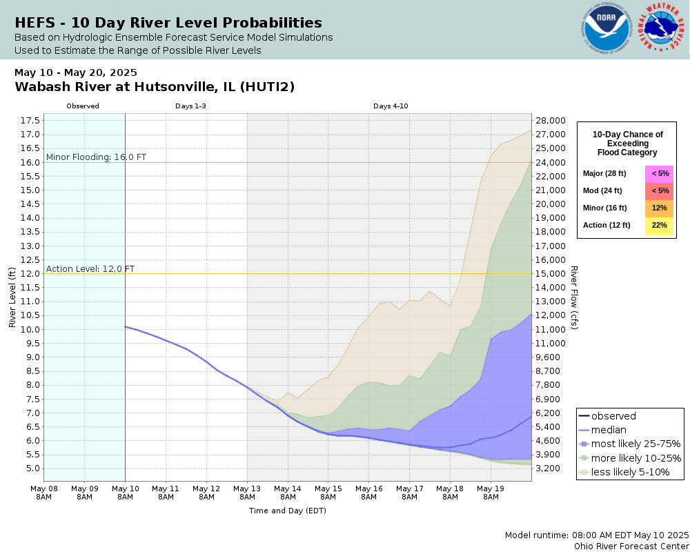
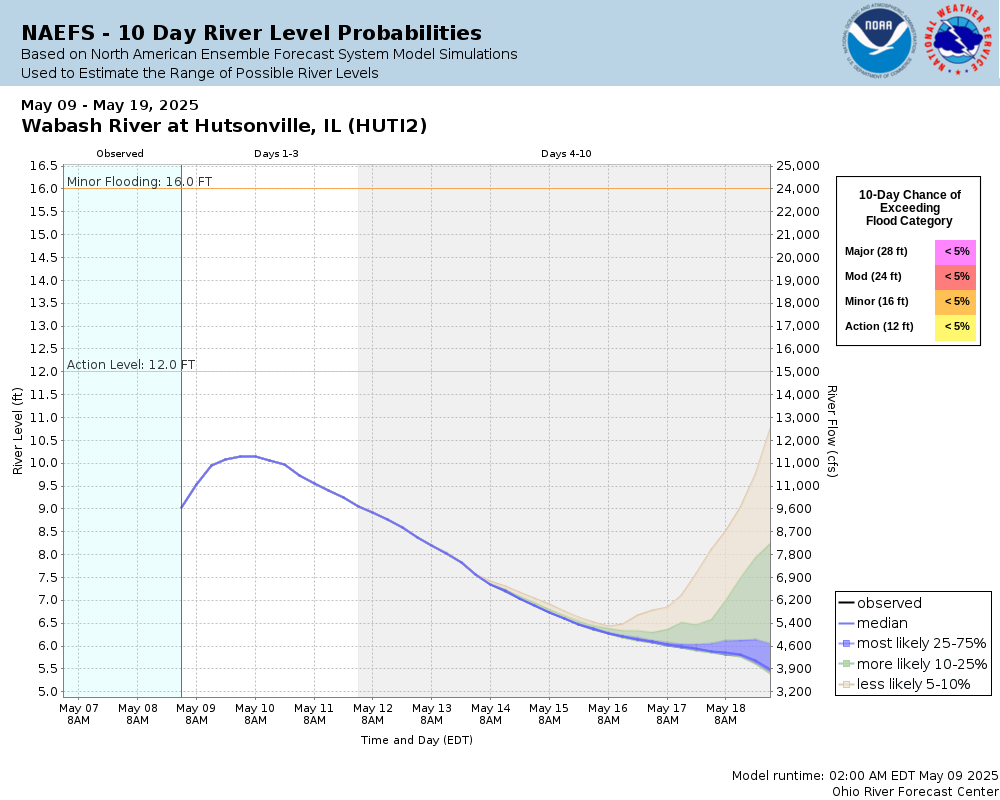
Potential River Levels Used to Estimate the Chance of Flooding and the Range of Possible River Levels |
||
| 10 Day (HEFS) | 10 Day (NAEFS) | 10 Day (GEFS) |
 |
 |
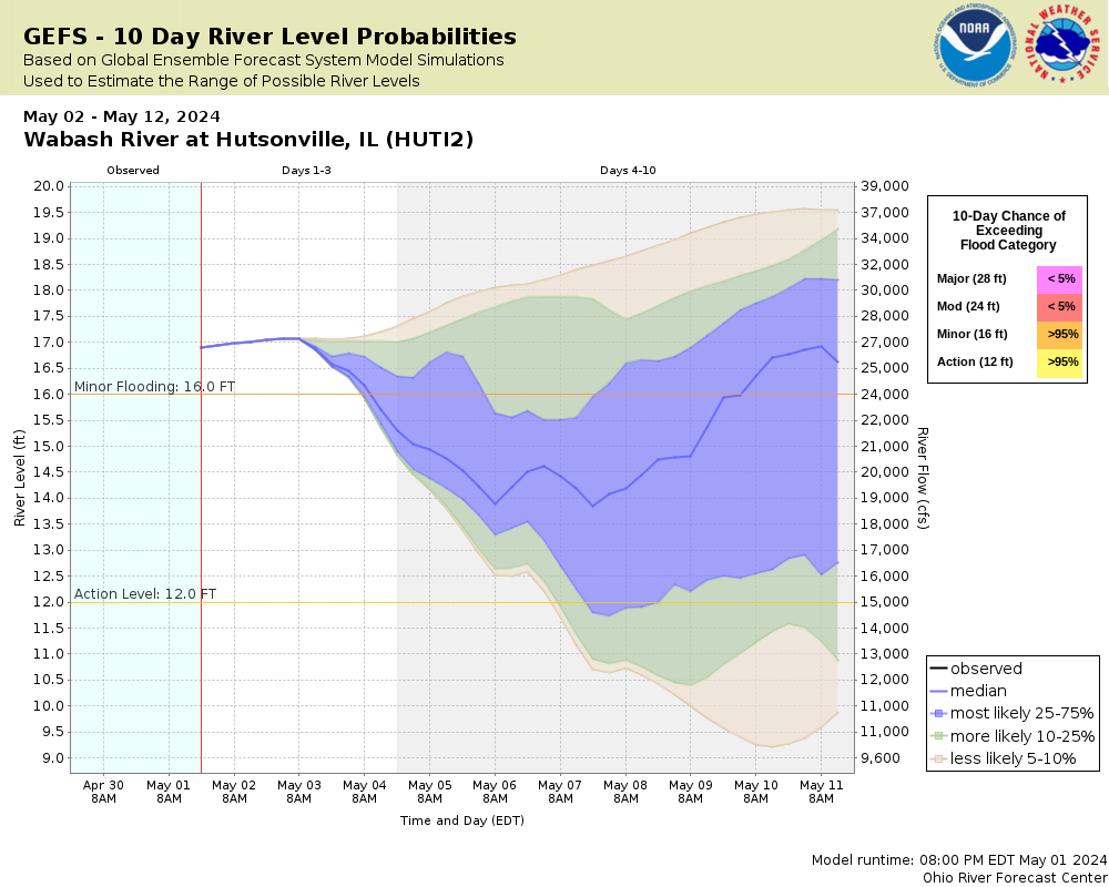 |
Note: Use the official hydrograph at the top of this web page for river levels within the next 72 hours.
Click individual graphics to enlarge.
Displayed on this site are the river forecast stages for the closed Hutsonville Power Plant when flooding is expected. During the April 2013 flood at Hutsonville, major problems were discovered between the readings taken on State Road 154 bridge and at this location. On April 24 the SR 154 readings were nearly 2 feet lower than the Power Plant reading. Use your long term flood marks during extreme stages as a referenceThis river site was operated by the former Central Illinois Public Service and is now closed.
Detailed stream discharges and gage heights as archived by the U.S. Geological Survey are not available.
Collaborative Agencies
The National Weather Service prepares its forecasts and other services in collaboration with agencies like the US Geological Survey, US Bureau of Reclamation, US Army Corps of Engineers, Natural Resource Conservation Service, National Park Service, ALERT Users Group, Bureau of Indian Affairs, and many state and local emergency managers across the country. For details, please click here.
Resources
Hydrologic Resource Links
- River Forecast Centers
- Text Products
- Forecast Precipitation
- US Geological Survey Surface Water
- How to Use US Geological Survey Water Alert Feature
- Water Resources Outlook
- Wabash River Conservation Area
- Water flow from Norway and Oakdale Dams
- Indianapolis Reservoir Levels
- Midwest Region U.S. Drought Monitor
- Indianapolis Museum of Art: FLOW Can You See the River?
- The Flood of 1913 - Remembered
- Friends of the White River
Additional Resource Links
- NWS Precipitation and River Forecasting
- Area Hydrographs
- Zoomable RFC Hourly Precipitation Maps
- Zoomable Snowfall Maps
- Indiana State Climate Office
- Community Collaborative Rain, Hail & Snow Network in Indiana
- Snow Information
- Midwestern Regional Climate Center
- Indiana Precipitation Frequencies
- Drainage Areas of Indiana Streams
- Ensemble River Forecasts
- Ohio River Forecast Center