West Fork Des Moines River at Jackson
Future / Actual / Minor
OWP 2.0 WWA Modal Title
01/11/2021, 10:04 PM UTC through 01/11/2021, 10:04 PM UTC
Sender
Sent
- Warning: no valid ratings curve available. Transformations to and from FEET/CFS/KCFS will not happen.
Traces and Thresholds Click to turn on/off display
Observed (OBS) 06/15/2025 5:00 AM CDTCATEGORY STAGE 
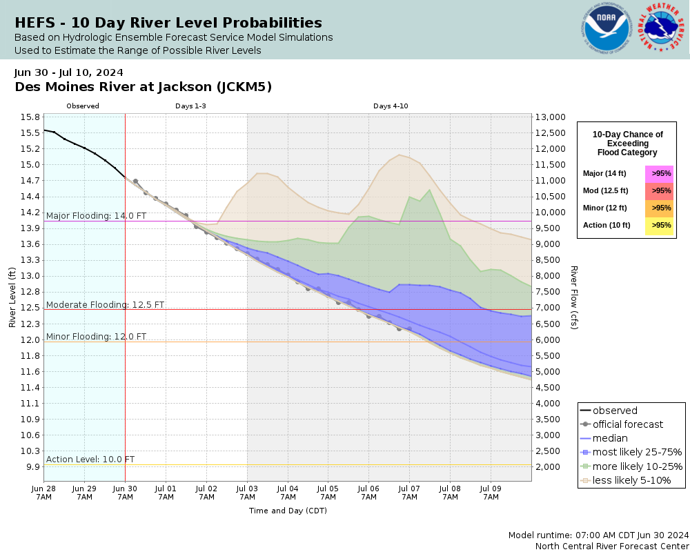
Major Flooding 14 ft Moderate Flooding 12.5 ft Minor Flooding 12 ft Action 10 ft Reliability of the Forecast:
NOTE: Forecasts are issued as needed during times of high water, but are not routinely available.
River forecasts for this location take into account past and future precipitation. The stages/flows that will occur may be different if future rainfall is different than forecast.
National Water Model Hydrograph
Official NWS streamflow forecasts are produced by NWS hydrologic forecasters for river gauge locations using hydrologic models which are calibrated to that location. This process considers additional guidance and information, including local expertise and experience, to produce the best forecast possible. The NWM output provides supplemental guidance to NWS forecasters and should not be considered an official NWS river forecast.
Flood Impacts
- 19 - The bridge on Hwy 71 in Jackson is overtopped.
- 17.5 - The highest levees in Jackson are overtopped causing major flooding of roads, homes, and businesses in Jackson.
- 15 - The low portions of River St begin to flood.
- 14 - Highway 71 will begin flooding, and flooding begins to affect homes and businesses along the non-leveed portions of the river in Jackson. Most of Ashley Park is flooded and the baseball fields are under 3-4 feet of water.
- 13.5 - The lower levees in Jackson are overtopped. Water begins to approach the edge of Highway 71 in Jackson and may approach some structures. Water reaches the bottom of the bridge on W Ashley St.
Gauge Location
Recent Crests
| 1. | 16.04 ft | on 06-26-2024 |
| 2. | 10.77 ft | on 04-18-2023 |
| 3. | 10.36 ft | on 06-14-2022 |
| 4. | 9.02 ft | on 04-12-2021 |
| 5. | 10.64 ft | on 04-04-2020 |
Recent Crests
| 1. | 16.04 ft | on 06-26-2024 |
| 2. | 10.77 ft | on 04-18-2023 |
| 3. | 10.36 ft | on 06-14-2022 |
| 4. | 9.02 ft | on 04-12-2021 |
| 5. | 10.64 ft | on 04-04-2020 |
| 6. | 14.08 ft | on 03-24-2019 |
| 7. | 13.92 ft | on 07-08-2018 |
| 8. | 10.50 ft | on 05-26-2017 |
Historic Crests
| 1. | 16.04 ft | on 06-26-2024 |
| 2. | 14.08 ft | on 03-24-2019 |
| 3. | 13.92 ft | on 07-08-2018 |
| 4. | 10.77 ft | on 04-18-2023 |
| 5. | 10.64 ft | on 04-04-2020 |
Historic Crests
| 1. | 16.04 ft | on 06-26-2024 |
| 2. | 14.08 ft | on 03-24-2019 |
| 3. | 13.92 ft | on 07-08-2018 |
| 4. | 10.77 ft | on 04-18-2023 |
| 5. | 10.64 ft | on 04-04-2020 |
| 6. | 10.50 ft | on 05-26-2017 |
| 7. | 10.36 ft | on 06-14-2022 |
| 8. | 9.02 ft | on 04-12-2021 |
Vertical Datum Table
| type | NAVD88 |
|---|---|
| major Flooding | 1306.07 ft |
| moderate Flooding | 1304.57 ft |
| minor Flooding | 1304.07 ft |
| action | 1302.07 ft |
| Latest Value | 1300.22 ft |
| Gauge Zero | 1292.07 ft |


Unique Local Info
***Gauge moved location in 2017 and thus peak stage data prior to 2017 is not comparable to current stage data. Peak stage of 19.45 ft from March 1969 is roughly comparable to 17.1 ft in current gauge readings.***
Live River Camera via USGS HIVIS Webpage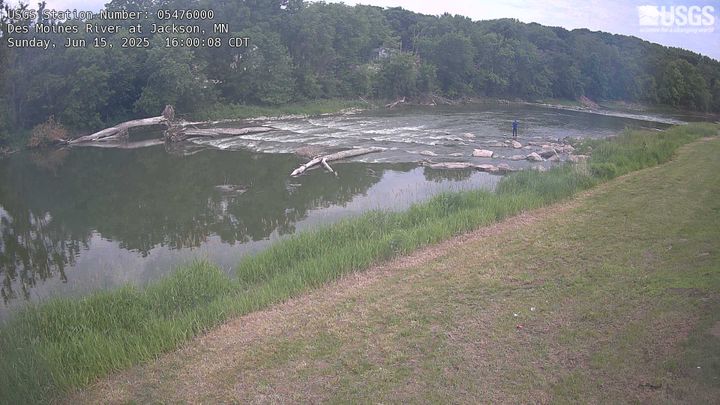
USGS 7-Day Streamflow Historical Comparison USGS WaterWatch Webpage
Collaborative Agencies
The National Weather Service prepares its forecasts and other services in collaboration with agencies like the US Geological Survey, US Bureau of Reclamation, US Army Corps of Engineers, Natural Resource Conservation Service, National Park Service, ALERT Users Group, Bureau of Indian Affairs, and many state and local emergency managers across the country. For details, please click here.
Resources
Hydrologic Resource Links
- River Forecast Centers
- NWS Sioux Falls Flooding Resource Page
- NOHRSC Snow Information
- USACE Missouri River Water Management
- USGS National Water Dashboard
- FEMA Flood Insurance Information
- South Dakota Flood Information System
- Iowa Flood Information System
- Missouri River Flood Information System
- Minnesota DNR
- Nebraska Real-Time Flood Forecasting
- ___