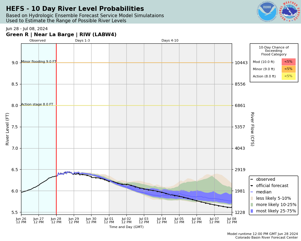
Green River (WY-UT-CO) near La Barge
Future / Actual / Minor
OWP 2.0 WWA Modal Title
01/11/2021, 10:04 PM UTC through 01/11/2021, 10:04 PM UTC
Sender
Sent
- Warning: no valid ratings curve available. Transformations to and from FEET/CFS/KCFS will not happen.
Traces and Thresholds Click to turn on/off display
Observed (OBS) 06/21/2025 2:00 AM MDTOfficial Forecast (FCST) 06/20/2025 9:00 AM MDTRecord: 10.5 ftCATEGORY STAGE 
Moderate Flooding 10 ft Minor Flooding 9 ft Action 8 ft Reliability of the Forecast: Based on current and forecast river, weather and reservoir conditions
NOTE: Forecasts are issued routinely year-round.
National Water Model Hydrograph
Official NWS streamflow forecasts are produced by NWS hydrologic forecasters for river gauge locations using hydrologic models which are calibrated to that location. This process considers additional guidance and information, including local expertise and experience, to produce the best forecast possible. The NWM output provides supplemental guidance to NWS forecasters and should not be considered an official NWS river forecast.
Flood Impacts
- 10.5 - Record stage and flow---18,800 cfs (6/9/1986).
- 10 - Nearby homes begin to see high water. Sublette County Road 318 south of town (to gas fields and gaging station) is nearly underwater at this stage. Whalen Road near LaBarge has up to 2 feet of water running over it. Widespread severe flooding of low lying agricultural land and all roads near the river.
- 9.5 - Sublette County Road 318 south LaBarge to gas fields has standing water over it. Lowland flooding becomes more severe and more widespread.
Gauge Info
| Coordinates | 42.1927, -110.163 |
| RFC | CBRFC |
| State | WY |
| WFO | RIW |
| County | Lincoln |
| Data Provider(s) | |
| US Geological Survey | USGS--Water Resources of the United States |
| USGS | 09209400 |
Gauge Location
Recent Crests
| 1. | 7.31 ft | on 06-09-2021 |
| 2. | 8.98 ft | on 06-09-2020 |
| 3. | 9.03 ft | on 06-10-2019 |
| 4. | 9.21 ft | on 06-21-2018 |
| 5. | 8.91 ft | on 06-03-2018 |
Recent Crests
| 1. | 7.31 ft | on 06-09-2021 | |
| 2. | 8.98 ft | on 06-09-2020 | |
| 3. | 9.03 ft | on 06-10-2019 | |
| 4. | 9.21 ft | on 06-21-2018 | |
| 5. | 8.91 ft | on 06-03-2018 | |
| 6. | 10.23 ft | on 06-11-2017 | |
| 7. | 8.36 ft | on 06-12-2016 | |
| 8. | 8.13 ft | on 06-13-2015 | |
| 9. | 6.65 ft | on 09-30-2014 | |
| 10. | 8.97 ft | on 06-02-2014 | |
| 11. | 7.10 ft | on 09-12-2013 | |
| 12. | 6.90 ft | on 05-18-2013 | |
| 13. | 7.76 ft | on 06-08-2012 | |
| 14. | 9.35 ft | on 07-03-2011 | |
| 15. | 8.34 ft | on 06-12-2010 | |
| 16. | 8.51 ft | on 06-05-2009 | |
| 17. | 7.74 ft | on 06-26-2008 | |
| 18. | 6.60 ft | on 05-22-2007 | |
| 19. | 7.88 ft | on 05-23-2006 | |
| 20. | 8.24 ft | on 06-25-2005 | |
| 21. | 7.54 ft | on 06-12-2004 | |
| 22. | 7.72 ft | on 06-02-2003 | |
| 23. | 7.08 ft | on 06-03-2002 | |
| 24. | 7.12 ft | on 05-18-2001 | |
| 25. | 7.40 ft | on 05-27-2000 | |
| 26. | 9.18 ft | on 06-24-1999 | |
| 27. | 8.11 ft | on 07-06-1998 | |
| 28. | 10.11 ft | on 06-13-1997 | |
| 29. | 9.28 ft | on 06-14-1996 | |
| 30. | 9.12 ft | on 06-19-1995 | |
| 31. | 7.48 ft | on 05-15-1994 | |
| 32. | 8.17 ft | on 06-04-1993 | |
| 33. | 6.31 ft | on 05-28-1992 | |
| 34. | 8.84 ft | on 06-15-1991 | |
| 35. | 8.03 ft | on 06-13-1990 | |
| 36. | 7.52 ft | on 06-18-1989 | |
| 37. | 7.16 ft | on 06-08-1988 | |
| 38. | 7.84 ft | on 05-22-1987 | |
| 39. | 10.50 ft | on 06-09-1986 | |
| 40. | 7.30 ft | on 05-27-1985 | |
| 41. | 8.00 ft | on 06-02-1984 | |
| 42. | 8.84 ft | on 06-14-1983 | |
| 43. | 9.44 ft | on 07-02-1982 | |
| 44. | 7.86 ft | on 06-11-1981 | |
| 45. | 8.56 ft | on 05-26-1980 | |
| 46. | 8.06 ft | on 05-30-1979 | |
| 47. | 8.80 ft | on 06-18-1978 | |
| 48. | 6.78 ft | on 06-12-1977 | |
| 49. | 8.25 ft | on 06-12-1976 | |
| 50. | 9.08 ft | on 07-10-1975 | |
| 51. | 9.16 ft | on 06-19-1974 | |
| 52. | 7.87 ft | on 06-12-1973 | |
| 53. | 10.34 ft | on 06-11-1972 | |
| 54. | 9.54 ft | on 06-22-1971 | |
| 55. | 8.12 ft | on 06-11-1970 | |
| 56. | 8.19 ft | on 06-10-1969 | |
| 57. | 8.57 ft | on 06-08-1968 | |
| 58. | 9.09 ft | on 06-25-1967 | |
| 59. | 7.12 ft | on 05-11-1966 | |
| 60. | 9.76 ft | on 06-28-1965 | |
| 61. | 7.55 ft | on 06-10-1964 | |
| 62. | 7.22 ft | on 06-18-1963 | 1 |
| 63. | 6.93 ft | on 06-24-1962 | 1 |
| 64. | 5.26 ft | on 05-31-1961 | 1 |
| 65. | 5.48 ft | on 06-11-1960 | 1 |
| 66. | 7.43 ft | on 06-19-1959 | 1 |
| 67. | 6.84 ft | on 05-28-1958 | 1 |
| 68. | 8.11 ft | on 06-10-1957 | 1 |
| 69. | 8.33 ft | on 06-06-1956 | 1 |
| 70. | 5.93 ft | on 06-16-1955 | 1 |
| 71. | 7.58 ft | on 06-30-1954 | 1 |
| 72. | 7.78 ft | on 06-18-1953 | 1 |
| 73. | 7.43 ft | on 06-10-1952 | 1 |
| 74. | 8.11 ft | on 05-31-1951 | 1 |
| 75. | 7.84 ft | on 06-19-1950 | 1 |
| 76. | 6.66 ft | on 06-21-1949 | 1 |
| 77. | 7.02 ft | on 06-05-1948 | 1 |
| 78. | 7.26 ft | on 07-22-1947 | 1 |
Historic Crests
| 1. | 10.50 ft | on 06-09-1986 |
| 2. | 10.34 ft | on 06-11-1972 |
| 3. | 10.23 ft | on 06-11-2017 |
| 4. | 10.11 ft | on 06-13-1997 |
| 5. | 9.76 ft | on 06-28-1965 |
Historic Crests
| 1. | 10.50 ft | on 06-09-1986 | |
| 2. | 10.34 ft | on 06-11-1972 | |
| 3. | 10.23 ft | on 06-11-2017 | |
| 4. | 10.11 ft | on 06-13-1997 | |
| 5. | 9.76 ft | on 06-28-1965 | |
| 6. | 9.54 ft | on 06-22-1971 | |
| 7. | 9.44 ft | on 07-02-1982 | |
| 8. | 9.35 ft | on 07-03-2011 | |
| 9. | 9.28 ft | on 06-14-1996 | |
| 10. | 9.21 ft | on 06-21-2018 | |
| 11. | 9.18 ft | on 06-24-1999 | |
| 12. | 9.16 ft | on 06-19-1974 | |
| 13. | 9.12 ft | on 06-19-1995 | |
| 14. | 9.09 ft | on 06-25-1967 | |
| 15. | 9.08 ft | on 07-10-1975 | |
| 16. | 9.03 ft | on 06-10-2019 | |
| 17. | 8.98 ft | on 06-09-2020 | |
| 18. | 8.97 ft | on 06-02-2014 | |
| 19. | 8.91 ft | on 06-03-2018 | |
| 20. | 8.84 ft | on 06-15-1991 | |
| 21. | 8.84 ft | on 06-14-1983 | |
| 22. | 8.80 ft | on 06-18-1978 | |
| 23. | 8.57 ft | on 06-08-1968 | |
| 24. | 8.56 ft | on 05-26-1980 | |
| 25. | 8.51 ft | on 06-05-2009 | |
| 26. | 8.36 ft | on 06-12-2016 | |
| 27. | 8.34 ft | on 06-12-2010 | |
| 28. | 8.33 ft | on 06-06-1956 | 1 |
| 29. | 8.25 ft | on 06-12-1976 | |
| 30. | 8.24 ft | on 06-25-2005 | |
| 31. | 8.19 ft | on 06-10-1969 | |
| 32. | 8.17 ft | on 06-04-1993 | |
| 33. | 8.13 ft | on 06-13-2015 | |
| 34. | 8.12 ft | on 06-11-1970 | |
| 35. | 8.11 ft | on 06-10-1957 | 1 |
| 36. | 8.11 ft | on 07-06-1998 | |
| 37. | 8.11 ft | on 05-31-1951 | 1 |
| 38. | 8.06 ft | on 05-30-1979 | |
| 39. | 8.03 ft | on 06-13-1990 | |
| 40. | 8.00 ft | on 06-02-1984 | |
| 41. | 7.88 ft | on 05-23-2006 | |
| 42. | 7.87 ft | on 06-12-1973 | |
| 43. | 7.86 ft | on 06-11-1981 | |
| 44. | 7.84 ft | on 06-19-1950 | 1 |
| 45. | 7.84 ft | on 05-22-1987 | |
| 46. | 7.78 ft | on 06-18-1953 | 1 |
| 47. | 7.76 ft | on 06-08-2012 | |
| 48. | 7.74 ft | on 06-26-2008 | |
| 49. | 7.72 ft | on 06-02-2003 | |
| 50. | 7.58 ft | on 06-30-1954 | 1 |
| 51. | 7.55 ft | on 06-10-1964 | |
| 52. | 7.54 ft | on 06-12-2004 | |
| 53. | 7.52 ft | on 06-18-1989 | |
| 54. | 7.48 ft | on 05-15-1994 | |
| 55. | 7.43 ft | on 06-19-1959 | 1 |
| 56. | 7.43 ft | on 06-10-1952 | 1 |
| 57. | 7.40 ft | on 05-27-2000 | |
| 58. | 7.31 ft | on 06-09-2021 | |
| 59. | 7.30 ft | on 05-27-1985 | |
| 60. | 7.26 ft | on 07-22-1947 | 1 |
| 61. | 7.22 ft | on 06-18-1963 | 1 |
| 62. | 7.16 ft | on 06-08-1988 | |
| 63. | 7.12 ft | on 05-18-2001 | |
| 64. | 7.12 ft | on 05-11-1966 | |
| 65. | 7.10 ft | on 09-12-2013 | |
| 66. | 7.08 ft | on 06-03-2002 | |
| 67. | 7.02 ft | on 06-05-1948 | 1 |
| 68. | 6.93 ft | on 06-24-1962 | 1 |
| 69. | 6.90 ft | on 05-18-2013 | |
| 70. | 6.84 ft | on 05-28-1958 | 1 |
| 71. | 6.78 ft | on 06-12-1977 | |
| 72. | 6.66 ft | on 06-21-1949 | 1 |
| 73. | 6.65 ft | on 09-30-2014 | |
| 74. | 6.60 ft | on 05-22-2007 | |
| 75. | 6.31 ft | on 05-28-1992 | |
| 76. | 5.93 ft | on 06-16-1955 | 1 |
| 77. | 5.48 ft | on 06-11-1960 | 1 |
| 78. | 5.26 ft | on 05-31-1961 | 1 |


Unique Local Info
USGS gage operated in cooperation with USBR.
Collaborative Agencies
The National Weather Service prepares its forecasts and other services in collaboration with agencies like the US Geological Survey, US Bureau of Reclamation, US Army Corps of Engineers, Natural Resource Conservation Service, National Park Service, ALERT Users Group, Bureau of Indian Affairs, and many state and local emergency managers across the country. For details, please click here.