Merrimack River at Lawrence
Future / Actual / Minor
OWP 2.0 WWA Modal Title
01/11/2021, 10:04 PM UTC through 01/11/2021, 10:04 PM UTC
Sender
Sent
- Upstream gauge unavailableDownstream gauge unavailableWarning: no valid ratings curve available. Transformations to and from FEET/CFS/KCFS will not happen.No secondary data available. Transformations for Flow data and a secondary Y axis cannot be made at this time.
Traces and Thresholds Click to turn on/off display
Observed (OBS) 06/26/2025 8:30 AM EDTCATEGORY STAGE 
Major Flooding 34 ft Moderate Flooding 29 ft Minor Flooding 24 ft Action 22 ft Reliability of the Forecast: Based on current and forecast river, weather and reservoir conditions
NOTE: Forecasts are issued as needed during times of high water, but are not routinely available.
Gauge reading affected by power generation.
National Water Model Hydrograph
Official NWS streamflow forecasts are produced by NWS hydrologic forecasters for river gauge locations using hydrologic models which are calibrated to that location. This process considers additional guidance and information, including local expertise and experience, to produce the best forecast possible. The NWM output provides supplemental guidance to NWS forecasters and should not be considered an official NWS river forecast.
Flood Impacts
- 36 - This is a major, life threatening flood. People in flood prone areas should prepare to evacuate. Follow the directions of local officials. Serious flood impacts are expected at some factories along the river. In addition, major backwater flooding is expected on the lower Shawsheen River in Lawrence, North Andover and Andover. Know alternate routes of travel to avoid flooded areas, and bridges that may be shut down.
- 34 - Flooding occurs on low lying roads and homes, as well as lower levels of buildings along the river's historic industrial corridor. This includes portions of Riverview Street and 90 Sutton Street in North Andover, and the Riverwalk Complex in Lawrence. Substantial backwater flooding is expected on the lower Shawsheen River in Lawrence, North Andover and Andover. This includes Route 114 at I-495 Exit 42 and Mass Ave and Commonwealth Ave at I-495.
- 32 - Moderate flooding is expected in Lawrence and North Andover. Some roads and homes along the river, as well as lower levels of factory buildings and low lying parking lots along the river's historic industrial corridor, are expected to experience flooding. In North Andover, North Main Street and Riverview as well as 90 Sutton Street are impacted. Backwater flooding on the lower Shawsheen River is expected in Lawrence, North Andover and Andover.
Gauge Info
| Coordinates | 42.7048, -71.1531 |
| RFC | NERFC |
| State | MA |
| WFO | BOX |
| County | Essex |
| Data Provider(s) | |
| US Geological Survey | USGS--Water Resources of the United States |
| USGS | 01100500 |
Gauge Location
Recent Crests
| 1. | 25.37 ft | on 12-20-2023 |
| 2. | 22.60 ft | on 04-28-2019 |
| 3. | 22.48 ft | on 04-01-2014 |
Recent Crests
| 1. | 25.37 ft | on 12-20-2023 |
| 2. | 22.60 ft | on 04-28-2019 |
| 3. | 22.48 ft | on 04-01-2014 |
Historic Crests
| 1. | 25.37 ft | on 12-20-2023 |
| 2. | 22.60 ft | on 04-28-2019 |
| 3. | 22.48 ft | on 04-01-2014 |
Historic Crests
| 1. | 25.37 ft | on 12-20-2023 |
| 2. | 22.60 ft | on 04-28-2019 |
| 3. | 22.48 ft | on 04-01-2014 |
Vertical Datum Table
| type | NAVD88 |
|---|---|
| major Flooding | 34.00 ft |
| moderate Flooding | 29.00 ft |
| minor Flooding | 24.00 ft |
| action | 22.00 ft |
| Latest Value | 9.87 ft |
| Gauge Zero | 0.00 ft |
Gauge Photos
No Images Found

Unique Local Info
|
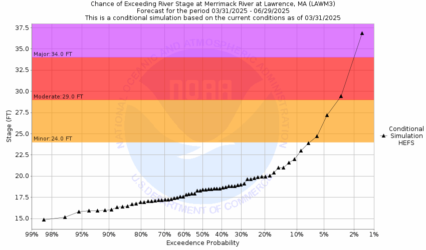
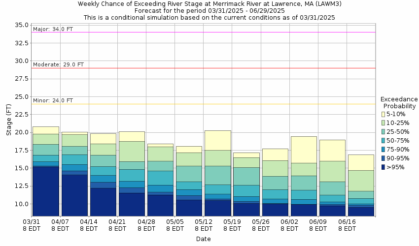
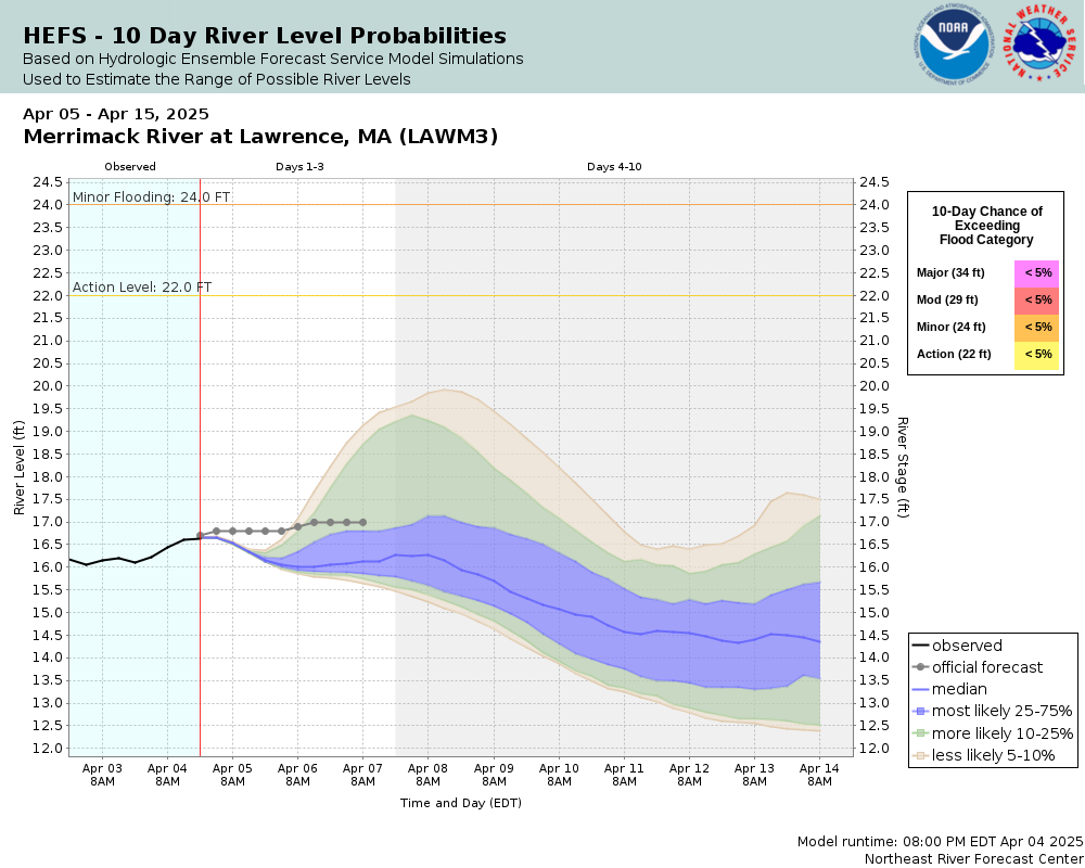
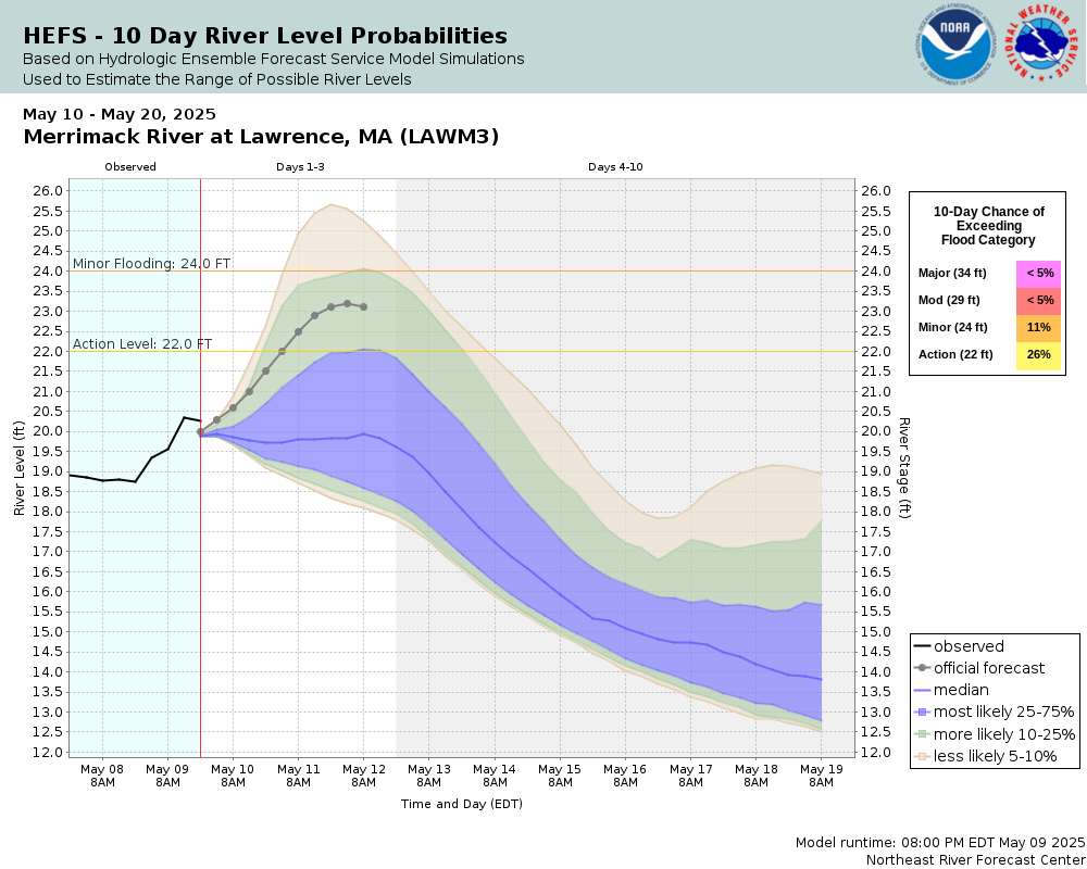
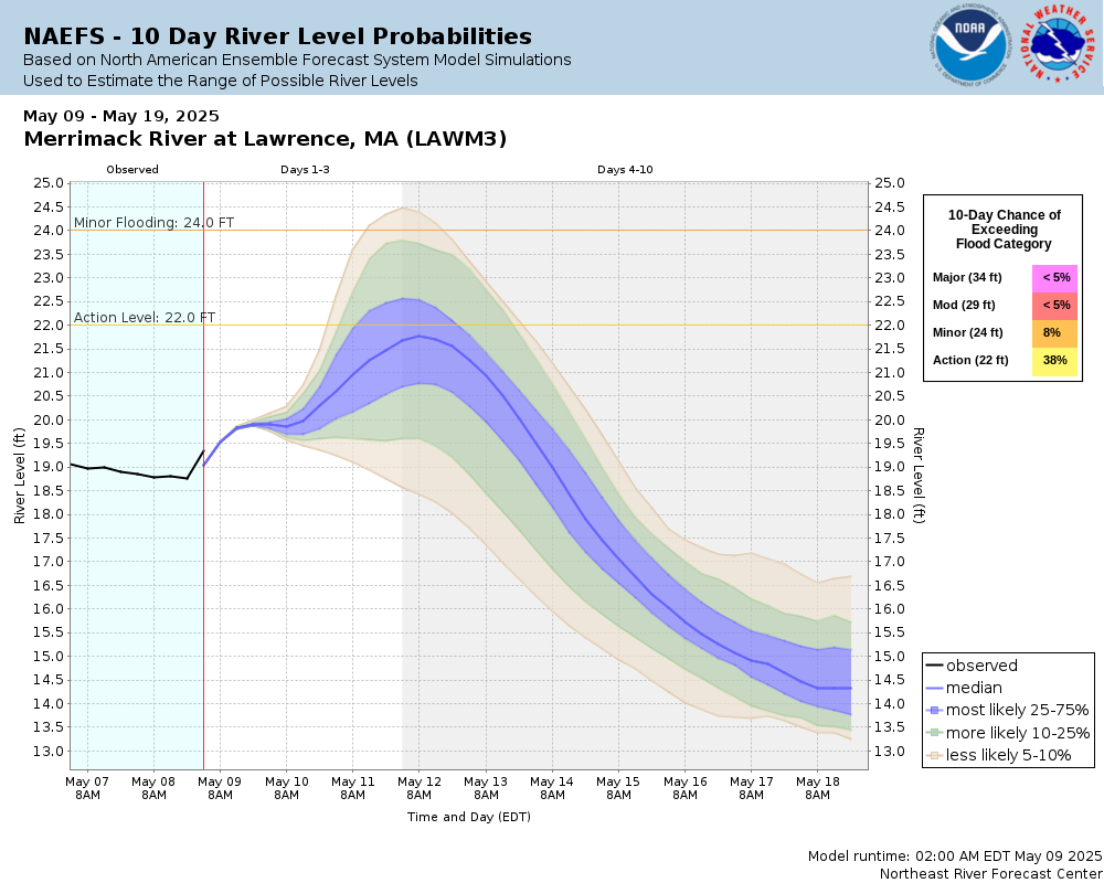
Potential River Levels Used to Estimate the Chance of Flooding and the Range of Possible River Levels |
||
| 10 Day (HEFS) | 10 Day (NAEFS) | 10 Day (GEFS) |
 |
 |
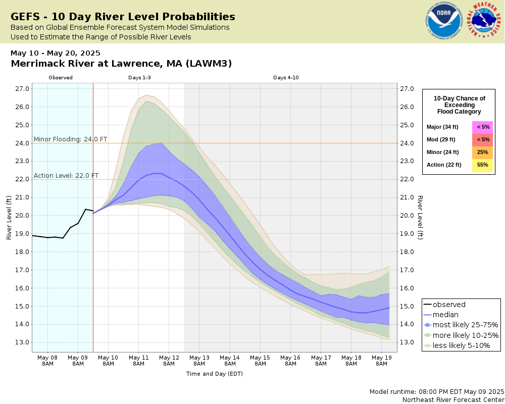 |
Note: Use the official hydrograph at the top of this web page for river levels within the next 72 hours.
Click individual graphics to enlarge.
Collaborative Agencies
The National Weather Service prepares its forecasts and other services in collaboration with agencies like the US Geological Survey, US Bureau of Reclamation, US Army Corps of Engineers, Natural Resource Conservation Service, National Park Service, ALERT Users Group, Bureau of Indian Affairs, and many state and local emergency managers across the country. For details, please click here.