SF Catawba River below George Poston Park, 1 N Lowell
Future / Actual / Minor
OWP 2.0 WWA Modal Title
01/11/2021, 10:04 PM UTC through 01/11/2021, 10:04 PM UTC
Sender
Sent
- Warning: no valid ratings curve available. Transformations to and from FEET/CFS/KCFS will not happen.
Traces and Thresholds Click to turn on/off display
Observed (OBS) 06/18/2025 10:15 PM EDTOfficial Forecast (FCST) 06/18/2025 10:04 AM EDTRecord: 21.3 ftLow Threshold: 0 ftCATEGORY STAGE 
Major Flooding 15.5 ft Moderate Flooding 13 ft Minor Flooding 10 ft Action 9 ft Reliability of the Forecast: Forecast data shown here are guidance values only. Please refer to your local NWS office.
NOTE: Forecasts are issued routinely year-round.
River forecasts for this location take into account past precipitation and the precipitation amounts expected approximately 48 hours into the future from the forecast issuance time.
National Water Model Hydrograph
Official NWS streamflow forecasts are produced by NWS hydrologic forecasters for river gauge locations using hydrologic models which are calibrated to that location. This process considers additional guidance and information, including local expertise and experience, to produce the best forecast possible. The NWM output provides supplemental guidance to NWS forecasters and should not be considered an official NWS river forecast.
Flood Impacts
- 17 - Major, devastating flooding of the town of Cramerton is ongoing.
- 16.5 - Major Flooding continues. Several roads adjacent to the South Fork Catawba River in Cramerton and McAdenville may be inundated. Significant flooding of homes and businesses along the river may be ongoing. Additionally, floodwaters may be inundating parts of Lakeview Dr. in McAdenville and and Catawba Run in Lowell. Floodwaters may be impacting the Willow Rd. water treatment plant in McAdenville.
- 15.5 - Major Flood Stage. South Fork Catawba River floodwaters may be inundating the Cramerton Fire Department, Cramerton Drug Store, the former South Fork Masonic Lodge building, and adjacent homes and businesses along 8th Ave. Floodwaters may be flooding the lowest elevations of the Cramerton Police Department parking lot. Flooding of Duharts Creek may be impacting adjacent sections of Mayflower Rd., and Cramer Mountain Rd. may be inundated with several inches of water.
Gauge Info
| Coordinates | 35.2853, -81.1011 |
| RFC | SERFC |
| State | NC |
| WFO | GSP |
| County | Gaston |
| Data Provider(s) | |
| US Geological Survey | USGS--Water Resources of the United States |
| USGS | 02145000 |
Gauge Location
Recent Crests
| 1. | 15.43 ft | on 09-28-2024 |
| 2. | 9.08 ft | on 08-08-2024 |
| 3. | 15.14 ft | on 01-10-2024 |
| 4. | 11.44 ft | on 12-28-2023 |
| 5. | 16.22 ft | on 02-07-2020 |
Recent Crests
| 1. | 15.43 ft | on 09-28-2024 |
| 2. | 9.08 ft | on 08-08-2024 |
| 3. | 15.14 ft | on 01-10-2024 |
| 4. | 11.44 ft | on 12-28-2023 |
| 5. | 16.22 ft | on 02-07-2020 |
| 6. | 14.10 ft | on 06-10-2019 |
| 7. | 11.02 ft | on 02-23-2019 |
| 8. | 11.05 ft | on 11-13-2018 |
| 9. | 9.30 ft | on 04-25-2018 |
| 10. | 9.35 ft | on 04-24-2017 |
| 11. | 3.10 ft | on 10-08-2016 |
| 12. | 12.39 ft | on 12-31-2015 |
| 13. | 9.13 ft | on 12-29-2015 |
| 14. | 9.79 ft | on 12-24-2015 |
| 15. | 9.97 ft | on 04-20-2015 |
| 16. | 10.34 ft | on 01-12-2014 |
| 17. | 17.50 ft | on 07-29-2013 |
| 18. | 11.29 ft | on 07-06-2013 |
| 19. | 10.51 ft | on 05-08-2013 |
| 20. | 10.86 ft | on 05-06-2013 |
| 21. | 9.48 ft | on 08-05-2011 |
| 22. | 6.39 ft | on 10-28-2010 |
| 23. | 11.90 ft | on 02-06-2010 |
| 24. | 12.70 ft | on 01-26-2010 |
| 25. | 11.52 ft | on 12-26-2009 |
| 26. | 9.80 ft | on 11-12-2009 |
| 27. | 11.80 ft | on 03-02-2007 |
| 28. | 12.96 ft | on 10-09-2005 |
| 29. | 7.12 ft | on 07-08-2005 |
| 30. | 11.46 ft | on 09-09-2004 |
| 31. | 12.67 ft | on 04-11-2003 |
| 32. | 15.88 ft | on 03-21-2003 |
| 33. | 8.69 ft | on 03-30-2001 |
| 34. | 8.57 ft | on 03-20-2000 |
| 35. | 6.85 ft | on 04-30-1999 |
| 36. | 11.04 ft | on 03-09-1998 |
| 37. | 10.56 ft | on 01-28-1998 |
| 38. | 12.97 ft | on 04-29-1997 |
| 39. | 10.28 ft | on 02-03-1996 |
| 40. | 13.12 ft | on 02-17-1995 |
| 41. | 10.65 ft | on 03-29-1994 |
| 42. | 11.71 ft | on 03-24-1993 |
| 43. | 12.06 ft | on 10-14-1990 |
| 44. | 12.67 ft | on 10-02-1989 |
| 45. | 15.72 ft | on 03-02-1987 |
| 46. | 12.10 ft | on 05-29-1984 |
| 47. | 10.10 ft | on 04-05-1975 |
| 48. | 12.50 ft | on 02-02-1973 |
| 49. | 11.00 ft | on 07-22-1972 |
| 50. | 17.38 ft | on 08-11-1970 |
| 51. | 11.03 ft | on 03-04-1966 |
| 52. | 14.20 ft | on 10-17-1964 |
| 53. | 12.59 ft | on 04-08-1964 |
| 54. | 12.11 ft | on 03-13-1963 |
| 55. | 12.60 ft | on 03-06-1963 |
| 56. | 12.39 ft | on 02-06-1960 |
| 57. | 11.68 ft | on 09-30-1959 |
| 58. | 11.79 ft | on 12-29-1958 |
| 59. | 13.05 ft | on 04-29-1958 |
| 60. | 13.36 ft | on 11-20-1957 |
| 61. | 11.04 ft | on 02-02-1957 |
| 62. | 13.32 ft | on 01-23-1954 |
| 63. | 10.58 ft | on 03-24-1953 |
| 64. | 10.84 ft | on 08-07-1952 |
| 65. | 12.45 ft | on 03-24-1952 |
| 66. | 15.30 ft | on 03-04-1952 |
| 67. | 11.94 ft | on 12-21-1951 |
| 68. | 11.09 ft | on 10-31-1949 |
| 69. | 12.67 ft | on 10-07-1949 |
| 70. | 11.57 ft | on 11-28-1948 |
| 71. | 10.60 ft | on 02-13-1948 |
| 72. | 10.60 ft | on 01-20-1947 |
| 73. | 12.95 ft | on 02-11-1946 |
| 74. | 12.04 ft | on 01-08-1946 |
| 75. | 16.98 ft | on 09-19-1945 |
| 76. | 11.98 ft | on 09-30-1944 |
| 77. | 12.88 ft | on 07-10-1943 |
| 78. | 10.54 ft | on 01-29-1943 |
| 79. | 21.33 ft | on 08-15-1940 |
Historic Crests
| 1. | 21.33 ft | on 08-15-1940 |
| 2. | 17.50 ft | on 07-29-2013 |
| 3. | 17.38 ft | on 08-11-1970 |
| 4. | 16.98 ft | on 09-19-1945 |
| 5. | 16.22 ft | on 02-07-2020 |
Historic Crests
| 1. | 21.33 ft | on 08-15-1940 |
| 2. | 17.50 ft | on 07-29-2013 |
| 3. | 17.38 ft | on 08-11-1970 |
| 4. | 16.98 ft | on 09-19-1945 |
| 5. | 16.22 ft | on 02-07-2020 |
| 6. | 15.88 ft | on 03-21-2003 |
| 7. | 15.72 ft | on 03-02-1987 |
| 8. | 15.43 ft | on 09-28-2024 |
| 9. | 15.30 ft | on 03-04-1952 |
| 10. | 15.14 ft | on 01-10-2024 |
| 11. | 14.20 ft | on 10-17-1964 |
| 12. | 14.10 ft | on 06-10-2019 |
| 13. | 13.36 ft | on 11-20-1957 |
| 14. | 13.32 ft | on 01-23-1954 |
| 15. | 13.12 ft | on 02-17-1995 |
| 16. | 13.05 ft | on 04-29-1958 |
| 17. | 12.97 ft | on 04-29-1997 |
| 18. | 12.96 ft | on 10-09-2005 |
| 19. | 12.95 ft | on 02-11-1946 |
| 20. | 12.88 ft | on 07-10-1943 |
| 21. | 12.70 ft | on 01-26-2010 |
| 22. | 12.67 ft | on 10-07-1949 |
| 23. | 12.67 ft | on 04-11-2003 |
| 24. | 12.67 ft | on 10-02-1989 |
| 25. | 12.60 ft | on 03-06-1963 |
| 26. | 12.59 ft | on 04-08-1964 |
| 27. | 12.50 ft | on 02-02-1973 |
| 28. | 12.45 ft | on 03-24-1952 |
| 29. | 12.39 ft | on 12-31-2015 |
| 30. | 12.39 ft | on 02-06-1960 |
| 31. | 12.11 ft | on 03-13-1963 |
| 32. | 12.10 ft | on 05-29-1984 |
| 33. | 12.06 ft | on 10-14-1990 |
| 34. | 12.04 ft | on 01-08-1946 |
| 35. | 11.98 ft | on 09-30-1944 |
| 36. | 11.94 ft | on 12-21-1951 |
| 37. | 11.90 ft | on 02-06-2010 |
| 38. | 11.80 ft | on 03-02-2007 |
| 39. | 11.79 ft | on 12-29-1958 |
| 40. | 11.71 ft | on 03-24-1993 |
| 41. | 11.68 ft | on 09-30-1959 |
| 42. | 11.57 ft | on 11-28-1948 |
| 43. | 11.52 ft | on 12-26-2009 |
| 44. | 11.46 ft | on 09-09-2004 |
| 45. | 11.44 ft | on 12-28-2023 |
| 46. | 11.29 ft | on 07-06-2013 |
| 47. | 11.09 ft | on 10-31-1949 |
| 48. | 11.05 ft | on 11-13-2018 |
| 49. | 11.04 ft | on 03-09-1998 |
| 50. | 11.04 ft | on 02-02-1957 |
| 51. | 11.03 ft | on 03-04-1966 |
| 52. | 11.02 ft | on 02-23-2019 |
| 53. | 11.00 ft | on 07-22-1972 |
| 54. | 10.86 ft | on 05-06-2013 |
| 55. | 10.84 ft | on 08-07-1952 |
| 56. | 10.65 ft | on 03-29-1994 |
| 57. | 10.60 ft | on 01-20-1947 |
| 58. | 10.60 ft | on 02-13-1948 |
| 59. | 10.58 ft | on 03-24-1953 |
| 60. | 10.56 ft | on 01-28-1998 |
| 61. | 10.54 ft | on 01-29-1943 |
| 62. | 10.51 ft | on 05-08-2013 |
| 63. | 10.34 ft | on 01-12-2014 |
| 64. | 10.28 ft | on 02-03-1996 |
| 65. | 10.10 ft | on 04-05-1975 |
| 66. | 9.97 ft | on 04-20-2015 |
| 67. | 9.80 ft | on 11-12-2009 |
| 68. | 9.79 ft | on 12-24-2015 |
| 69. | 9.48 ft | on 08-05-2011 |
| 70. | 9.35 ft | on 04-24-2017 |
| 71. | 9.30 ft | on 04-25-2018 |
| 72. | 9.13 ft | on 12-29-2015 |
| 73. | 9.08 ft | on 08-08-2024 |
| 74. | 8.69 ft | on 03-30-2001 |
| 75. | 8.57 ft | on 03-20-2000 |
| 76. | 7.12 ft | on 07-08-2005 |
| 77. | 6.85 ft | on 04-30-1999 |
| 78. | 6.39 ft | on 10-28-2010 |
| 79. | 3.10 ft | on 10-08-2016 |
Vertical Datum Table
| type | NAVD88 |
|---|---|
| major Flooding | 617.78 ft |
| moderate Flooding | 615.28 ft |
| minor Flooding | 612.28 ft |
| action | 611.28 ft |
| Latest Value | 605.95 ft |
| Gauge Zero | 602.28 ft |


Unique Local Info
|
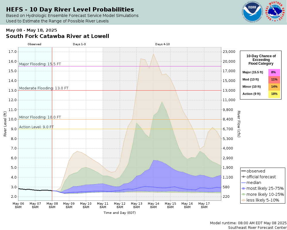
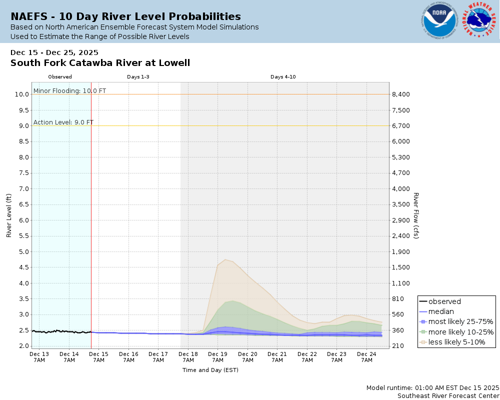
Potential River Level (Ensemble) Hydrographs Used to Estimate the Chance of Flooding and the Range of Possible River Levels Over the Next 10 Days |
||
| Hydrologic Ensemble Forecast Service (HEFS) | North American Ensemble Forecast System (NAEFS) | Global Ensemble Forecast System (GEFS) |
 |
 |
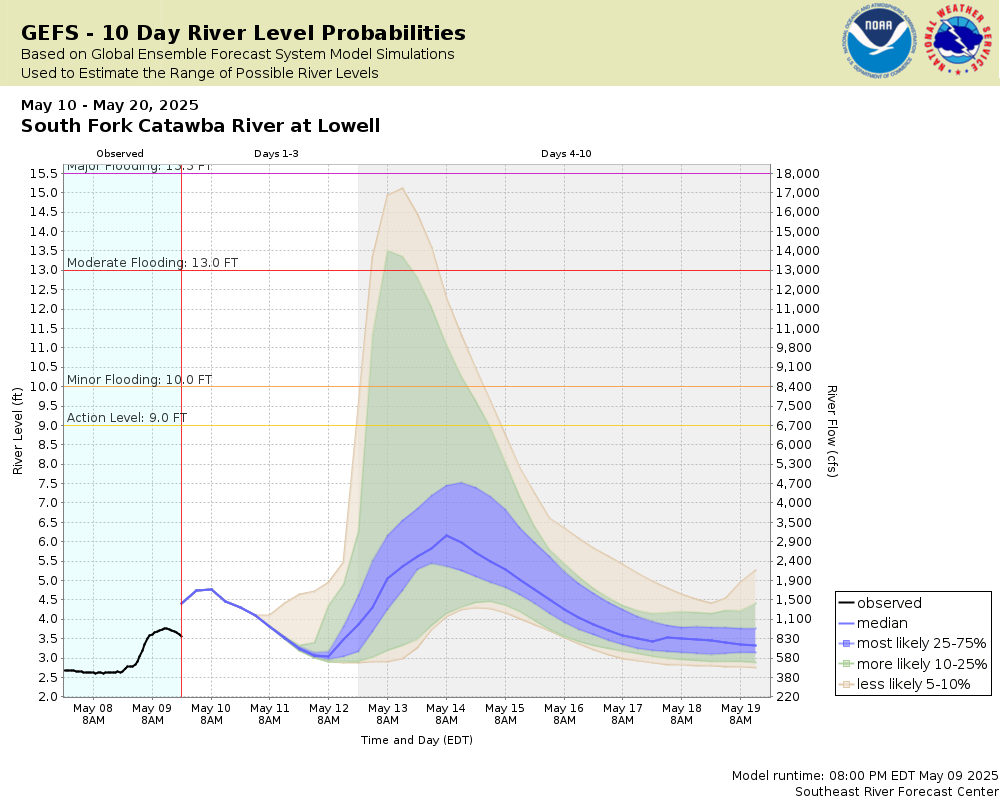 |
Note: The hydrograph at the top of the page is the official NWS forecast for this location based on 48 hours of forecasted rainfall. The ensemble hydrographs shown here are used to assess the range of possible river levels and likelihood of river flooding over the next 10 days using dozens of model-derived, 10-day rainfall forecasts.
See the Product Description Document link for more information on the Meteorological Model-based Ensemble Forecasting System (MMEFS) which produces the ensemble hydrographs above.
Clicking on each ensemble hydrograph enlarges the graph and takes you to the MMEFS website for additional guidance.
Collaborative Agencies
The National Weather Service prepares its forecasts and other services in collaboration with agencies like the US Geological Survey, US Bureau of Reclamation, US Army Corps of Engineers, Natural Resource Conservation Service, National Park Service, ALERT Users Group, Bureau of Indian Affairs, and many state and local emergency managers across the country. For details, please click here.