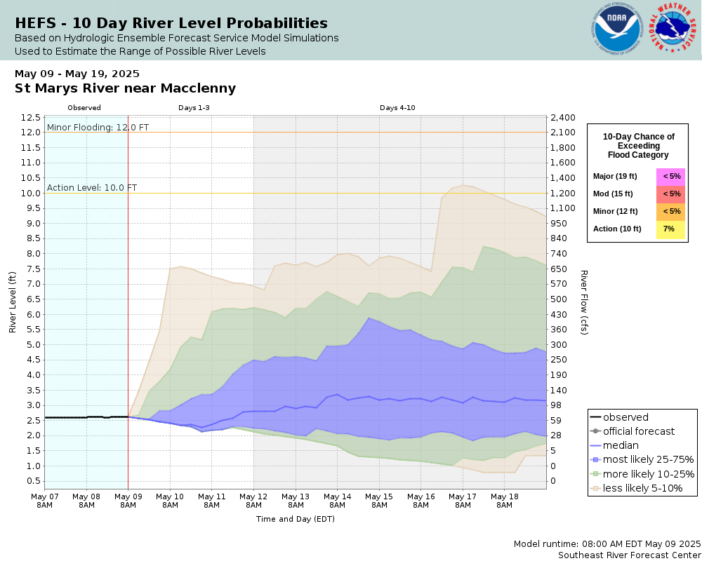
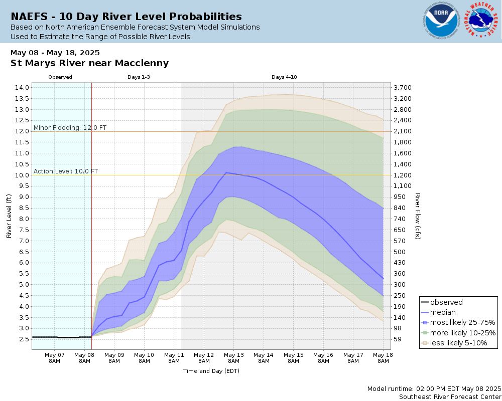
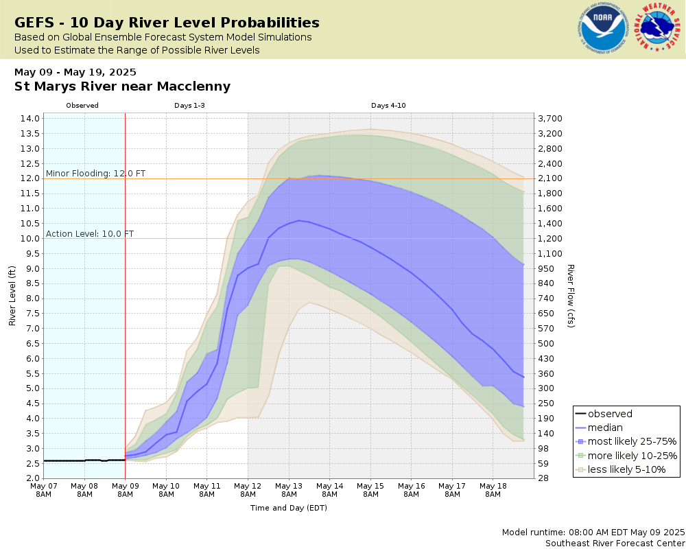
St. Marys River near Macclenny
Future / Actual / Minor
OWP 2.0 WWA Modal Title
01/11/2021, 10:04 PM UTC through 01/11/2021, 10:04 PM UTC
Sender
Sent
- Downstream gauge unavailableWarning: no valid ratings curve available. Transformations to and from FEET/CFS/KCFS will not happen.
Traces and Thresholds Click to turn on/off display
Observed (OBS) 03/16/2025 11:45 AM EDTOfficial Forecast (FCST) 03/16/2025 10:51 AM EDTRecord: 24.4 ftLow Threshold: 1.5 ftCATEGORY STAGE 
Major Flooding 19 ft Moderate Flooding 15 ft Minor Flooding 12 ft Action 10 ft Reliability of the Forecast:
NOTE: Forecasts are issued as needed during times of high water, but are not routinely available.
River forecasts for this location take into account past precipitation and the precipitation amounts expected approximately 48 hours into the future from the forecast issuance time.
National Water Model Hydrograph
Official NWS streamflow forecasts are produced by NWS hydrologic forecasters for river gauge locations using hydrologic models which are calibrated to that location. This process considers additional guidance and information, including local expertise and experience, to produce the best forecast possible. The NWM output provides supplemental guidance to NWS forecasters and should not be considered an official NWS river forecast.
Flood Impacts
- 20 - High banks on the Florida side begin to overflow. Trailers and houses along the river in Baker County are endangered. Trailers and houses on the Georgia side near Stokesville are endangered.
- 17 - High water on the river reaches the bottom of the Stokes Road Bridge.
- 16 - Access roads on both sides of the river in Florida and Georgia are flooded, including the entire low lying stretch of St. Mary's River Bluff Road on the Georgia side which cuts off 40 to 50 homes. On the Florida side, the lower end of St. Mary's Cove Road past the public boat ramp becomes flooded and cuts off access to 20 to 30 homes. The Stokes Road Bridge over the river is generally closed due to high water.
Gauge Info
| Coordinates | 30.3586, -82.0817 |
| RFC | SERFC |
| State | FL |
| WFO | JAX |
| County | Baker |
| Data Provider(s) | |
| US Geological Survey | USGS--Water Resources of the United States |
| USGS | 02231000 |
Gauge Location
Recent Crests
| 1. | 19.71 ft | on 08-07-2024 |
| 2. | 12.25 ft | on 01-18-2024 |
| 3. | 13.15 ft | on 01-12-2024 |
| 4. | 17.09 ft | on 12-18-2023 |
| 5. | 12.65 ft | on 08-03-2023 |
Recent Crests
| 1. | 19.71 ft | on 08-07-2024 |
| 2. | 12.25 ft | on 01-18-2024 |
| 3. | 13.15 ft | on 01-12-2024 |
| 4. | 17.09 ft | on 12-18-2023 |
| 5. | 12.65 ft | on 08-03-2023 |
| 6. | 12.86 ft | on 09-12-2022 |
| 7. | 13.33 ft | on 09-06-2022 |
| 8. | 12.85 ft | on 08-30-2022 |
| 9. | 13.31 ft | on 03-26-2022 |
| 10. | 14.52 ft | on 03-14-2022 |
| 11. | 13.08 ft | on 11-08-2021 |
| 12. | 13.33 ft | on 09-24-2021 |
| 13. | 17.54 ft | on 08-07-2021 |
| 14. | 12.54 ft | on 07-29-2021 |
| 15. | 17.33 ft | on 07-10-2021 |
| 16. | 13.49 ft | on 02-20-2021 |
| 17. | 13.39 ft | on 02-17-2021 |
| 18. | 14.47 ft | on 08-14-2020 |
| 19. | 15.51 ft | on 06-14-2020 |
| 20. | 12.10 ft | on 01-30-2019 |
| 21. | 13.05 ft | on 12-17-2018 |
| 22. | 12.41 ft | on 08-05-2018 |
| 23. | 12.93 ft | on 07-03-2018 |
| 24. | 12.07 ft | on 06-02-2018 |
| 25. | 22.32 ft | on 09-12-2017 |
| 26. | 12.04 ft | on 09-03-2017 |
| 27. | 12.88 ft | on 08-09-2017 |
| 28. | 13.63 ft | on 08-04-2017 |
| 29. | 13.79 ft | on 09-05-2016 |
| 30. | 11.38 ft | on 09-09-2015 |
| 31. | 11.80 ft | on 12-26-2014 |
| 32. | 12.65 ft | on 10-02-2014 |
| 33. | 16.36 ft | on 09-11-2014 |
| 34. | 12.21 ft | on 06-08-2014 |
| 35. | 11.40 ft | on 05-18-2014 |
| 36. | 15.15 ft | on 04-21-2014 |
| 37. | 15.35 ft | on 04-10-2014 |
| 38. | 11.95 ft | on 03-31-2014 |
| 39. | 14.60 ft | on 03-19-2014 |
| 40. | 11.06 ft | on 03-09-2014 |
| 41. | 10.87 ft | on 01-16-2014 |
| 42. | 10.64 ft | on 09-01-2013 |
| 43. | 12.32 ft | on 08-25-2013 |
| 44. | 10.82 ft | on 07-24-2013 |
| 45. | 13.15 ft | on 07-07-2013 |
| 46. | 12.14 ft | on 05-06-2013 |
| 47. | 10.54 ft | on 03-26-2013 |
| 48. | 10.56 ft | on 02-27-2013 |
| 49. | 10.54 ft | on 10-09-2012 |
| 50. | 11.98 ft | on 08-23-2012 |
| 51. | 11.22 ft | on 08-10-2012 |
| 52. | 24.38 ft | on 06-28-2012 |
| 53. | 10.13 ft | on 02-12-2011 |
| 54. | 11.81 ft | on 02-15-2010 |
| 55. | 10.78 ft | on 01-26-2010 |
| 56. | 11.01 ft | on 01-23-2010 |
| 57. | 12.12 ft | on 06-09-2009 |
| 58. | 15.59 ft | on 05-27-2009 |
| 59. | 13.68 ft | on 05-23-2009 |
| 60. | 14.58 ft | on 04-05-2009 |
| 61. | 16.62 ft | on 08-30-2008 |
| 62. | 21.14 ft | on 08-24-2008 |
| 63. | 12.69 ft | on 03-10-2008 |
| 64. | 10.51 ft | on 02-25-2008 |
| 65. | 13.62 ft | on 08-05-2007 |
| 66. | 12.25 ft | on 02-06-2006 |
| 67. | 12.00 ft | on 01-05-2006 |
| 68. | 13.84 ft | on 12-20-2005 |
| 69. | 10.65 ft | on 10-09-2005 |
| 70. | 13.34 ft | on 08-09-2005 |
| 71. | 11.32 ft | on 08-04-2005 |
| 72. | 12.50 ft | on 07-17-2005 |
| 73. | 13.73 ft | on 07-04-2005 |
| 74. | 13.92 ft | on 04-09-2005 |
| 75. | 15.21 ft | on 04-03-2005 |
| 76. | 13.03 ft | on 03-29-2005 |
| 77. | 11.74 ft | on 03-02-2005 |
| 78. | 18.20 ft | on 09-29-2004 |
| 79. | 21.06 ft | on 09-08-2004 |
| 80. | 12.60 ft | on 08-25-2003 |
| 81. | 11.26 ft | on 06-21-2003 |
| 82. | 18.33 ft | on 03-10-2003 |
| 83. | 17.67 ft | on 03-03-2003 |
| 84. | 10.57 ft | on 01-03-2003 |
| 85. | 11.77 ft | on 03-05-2002 |
| 86. | 17.18 ft | on 10-04-1998 |
| 87. | 13.03 ft | on 03-21-1998 |
| 88. | 12.75 ft | on 03-11-1998 |
| 89. | 18.85 ft | on 02-24-1998 |
| 90. | 19.69 ft | on 02-19-1998 |
| 91. | 13.23 ft | on 02-05-1998 |
| 92. | 14.59 ft | on 01-29-1998 |
| 93. | 14.17 ft | on 01-25-1998 |
| 94. | 13.56 ft | on 12-17-1997 |
| 95. | 13.62 ft | on 08-04-1997 |
| 96. | 13.91 ft | on 04-30-1997 |
| 97. | 19.62 ft | on 10-08-1996 |
| 98. | 12.04 ft | on 09-17-1995 |
| 99. | 16.71 ft | on 10-13-1994 |
| 100. | 13.78 ft | on 10-05-1994 |
| 101. | 14.50 ft | on 02-01-1994 |
| 102. | 10.78 ft | on 11-12-1993 |
| 103. | 10.66 ft | on 11-08-1993 |
| 104. | 19.81 ft | on 10-04-1992 |
| 105. | 12.10 ft | on 08-23-1992 |
| 106. | 11.67 ft | on 08-10-1992 |
| 107. | 11.69 ft | on 10-04-1991 |
| 108. | 13.00 ft | on 08-07-1991 |
| 109. | 10.63 ft | on 07-31-1991 |
| 110. | 10.52 ft | on 07-26-1991 |
| 111. | 10.53 ft | on 07-22-1991 |
| 112. | 10.56 ft | on 07-20-1991 |
| 113. | 11.83 ft | on 07-14-1991 |
| 114. | 10.89 ft | on 07-01-1991 |
| 115. | 14.03 ft | on 06-07-1991 |
| 116. | 13.50 ft | on 04-25-1991 |
| 117. | 12.37 ft | on 03-20-1991 |
| 118. | 14.30 ft | on 03-05-1991 |
| 119. | 11.54 ft | on 02-01-1991 |
| 120. | 11.20 ft | on 09-30-1989 |
| 121. | 17.43 ft | on 09-09-1988 |
| 122. | 11.69 ft | on 09-04-1988 |
| 123. | 11.45 ft | on 03-11-1988 |
| 124. | 12.05 ft | on 03-07-1988 |
| 125. | 16.53 ft | on 02-22-1988 |
| 126. | 13.08 ft | on 08-18-1987 |
| 127. | 15.51 ft | on 03-31-1987 |
| 128. | 12.23 ft | on 03-09-1987 |
| 129. | 12.40 ft | on 03-03-1987 |
| 130. | 13.54 ft | on 02-24-1987 |
| 131. | 13.33 ft | on 02-09-1987 |
| 132. | 13.12 ft | on 01-25-1987 |
| 133. | 12.71 ft | on 03-17-1986 |
| 134. | 15.18 ft | on 02-12-1986 |
| 135. | 14.70 ft | on 01-13-1986 |
| 136. | 11.63 ft | on 01-07-1986 |
| 137. | 15.66 ft | on 12-31-1985 |
| 138. | 14.92 ft | on 09-03-1985 |
| 139. | 10.95 ft | on 08-12-1985 |
| 140. | 13.24 ft | on 09-30-1984 |
| 141. | 11.83 ft | on 08-03-1984 |
| 142. | 14.41 ft | on 04-10-1984 |
| 143. | 17.11 ft | on 04-05-1984 |
| 144. | 16.62 ft | on 03-30-1984 |
| 145. | 13.12 ft | on 03-08-1984 |
| 146. | 13.23 ft | on 02-29-1984 |
| 147. | 15.56 ft | on 12-31-1983 |
| 148. | 13.69 ft | on 07-03-1983 |
| 149. | 14.36 ft | on 04-11-1983 |
| 150. | 14.61 ft | on 03-20-1983 |
| 151. | 10.52 ft | on 03-09-1983 |
| 152. | 13.33 ft | on 02-16-1983 |
| 153. | 10.52 ft | on 08-11-1982 |
| 154. | 11.42 ft | on 04-18-1982 |
| 155. | 12.64 ft | on 04-13-1982 |
| 156. | 11.32 ft | on 04-03-1981 |
| 157. | 10.82 ft | on 03-07-1981 |
| 158. | 11.18 ft | on 02-21-1981 |
| 159. | 12.91 ft | on 04-05-1980 |
| 160. | 12.22 ft | on 04-01-1980 |
| 161. | 16.35 ft | on 03-12-1980 |
| 162. | 14.58 ft | on 09-29-1979 |
| 163. | 13.90 ft | on 09-26-1979 |
| 164. | 14.19 ft | on 09-18-1979 |
| 165. | 10.73 ft | on 09-06-1979 |
| 166. | 11.21 ft | on 08-07-1979 |
| 167. | 14.11 ft | on 05-13-1979 |
| 168. | 14.59 ft | on 05-06-1978 |
| 169. | 12.41 ft | on 03-17-1978 |
| 170. | 12.42 ft | on 03-11-1978 |
| 171. | 12.44 ft | on 03-05-1978 |
| 172. | 11.72 ft | on 02-20-1978 |
| 173. | 13.26 ft | on 01-22-1978 |
| 174. | 12.74 ft | on 12-08-1977 |
| 175. | 12.06 ft | on 12-04-1977 |
| 176. | 13.33 ft | on 09-24-1977 |
| 177. | 13.20 ft | on 09-07-1977 |
| 178. | 12.15 ft | on 08-27-1977 |
| 179. | 11.78 ft | on 08-24-1977 |
| 180. | 12.35 ft | on 02-06-1977 |
| 181. | 11.87 ft | on 01-06-1977 |
| 182. | 11.18 ft | on 05-27-1976 |
| 183. | 12.94 ft | on 09-15-1975 |
| 184. | 11.04 ft | on 09-11-1975 |
| 185. | 10.70 ft | on 08-14-1975 |
| 186. | 10.57 ft | on 08-11-1975 |
| 187. | 13.75 ft | on 08-01-1975 |
| 188. | 11.12 ft | on 07-19-1975 |
| 189. | 10.70 ft | on 05-19-1975 |
| 190. | 14.50 ft | on 04-17-1975 |
| 191. | 15.50 ft | on 09-07-1974 |
| 192. | 15.28 ft | on 08-22-1974 |
| 193. | 11.49 ft | on 08-07-1974 |
| 194. | 11.63 ft | on 06-27-1973 |
| 195. | 11.34 ft | on 06-24-1973 |
| 196. | 10.67 ft | on 06-09-1973 |
| 197. | 12.24 ft | on 06-02-1973 |
| 198. | 22.86 ft | on 04-05-1973 |
| 199. | 12.23 ft | on 03-12-1973 |
| 200. | 12.81 ft | on 02-17-1973 |
| 201. | 12.38 ft | on 02-12-1973 |
| 202. | 11.39 ft | on 02-04-1973 |
| 203. | 11.93 ft | on 01-31-1973 |
| 204. | 10.76 ft | on 08-31-1972 |
| 205. | 14.01 ft | on 06-29-1972 |
| 206. | 13.21 ft | on 06-22-1972 |
| 207. | 12.99 ft | on 04-02-1972 |
| 208. | 10.66 ft | on 02-19-1972 |
| 209. | 11.52 ft | on 02-09-1972 |
| 210. | 11.37 ft | on 02-05-1972 |
| 211. | 12.07 ft | on 01-25-1972 |
| 212. | 13.35 ft | on 01-16-1972 |
| 213. | 10.85 ft | on 12-23-1971 |
| 214. | 13.59 ft | on 08-28-1971 |
| 215. | 15.96 ft | on 08-20-1971 |
| 216. | 14.61 ft | on 08-28-1970 |
| 217. | 15.24 ft | on 08-22-1970 |
| 218. | 14.77 ft | on 08-15-1970 |
| 219. | 19.88 ft | on 03-31-1970 |
| 220. | 12.19 ft | on 02-20-1970 |
| 221. | 16.16 ft | on 02-04-1970 |
| 222. | 11.21 ft | on 01-17-1970 |
| 223. | 13.13 ft | on 01-08-1970 |
| 224. | 14.14 ft | on 12-12-1969 |
| 225. | 15.37 ft | on 11-02-1969 |
| 226. | 12.87 ft | on 10-05-1969 |
| 227. | 12.25 ft | on 09-25-1969 |
| 228. | 11.60 ft | on 03-21-1969 |
| 229. | 13.83 ft | on 08-31-1968 |
| 230. | 10.72 ft | on 06-08-1968 |
| 231. | 11.93 ft | on 09-01-1967 |
| 232. | 11.43 ft | on 08-15-1967 |
| 233. | 14.75 ft | on 02-15-1967 |
| 234. | 10.75 ft | on 01-06-1967 |
| 235. | 14.31 ft | on 10-12-1966 |
| 236. | 12.82 ft | on 10-04-1966 |
| 237. | 11.90 ft | on 08-27-1966 |
| 238. | 14.04 ft | on 08-12-1966 |
| 239. | 13.55 ft | on 07-05-1966 |
| 240. | 11.50 ft | on 06-21-1966 |
| 241. | 11.88 ft | on 06-12-1966 |
| 242. | 11.20 ft | on 05-19-1966 |
| 243. | 10.73 ft | on 05-11-1966 |
| 244. | 14.66 ft | on 03-16-1966 |
| 245. | 14.65 ft | on 03-07-1966 |
| 246. | 15.19 ft | on 03-02-1966 |
| 247. | 14.33 ft | on 02-21-1966 |
| 248. | 15.12 ft | on 01-28-1966 |
| 249. | 12.22 ft | on 12-22-1965 |
| 250. | 12.65 ft | on 10-02-1965 |
| 251. | 14.22 ft | on 08-17-1965 |
| 252. | 11.60 ft | on 08-10-1965 |
| 253. | 11.99 ft | on 07-22-1965 |
| 254. | 11.67 ft | on 06-28-1965 |
| 255. | 11.69 ft | on 03-22-1965 |
| 256. | 13.33 ft | on 03-06-1965 |
| 257. | 11.75 ft | on 02-20-1965 |
| 258. | 11.80 ft | on 02-17-1965 |
| 259. | 16.68 ft | on 12-28-1964 |
| 260. | 13.06 ft | on 12-07-1964 |
| 261. | 23.25 ft | on 09-13-1964 |
| 262. | 14.33 ft | on 08-30-1964 |
| 263. | 12.60 ft | on 08-24-1964 |
| 264. | 10.95 ft | on 08-15-1964 |
| 265. | 13.88 ft | on 08-02-1964 |
| 266. | 13.54 ft | on 07-29-1964 |
| 267. | 20.64 ft | on 05-04-1964 |
| 268. | 16.71 ft | on 03-01-1964 |
| 269. | 10.99 ft | on 02-20-1964 |
| 270. | 11.77 ft | on 02-10-1964 |
| 271. | 14.33 ft | on 01-19-1964 |
| 272. | 14.39 ft | on 01-14-1964 |
| 273. | 16.39 ft | on 09-30-1963 |
| 274. | 11.03 ft | on 03-03-1963 |
| 275. | 11.08 ft | on 02-27-1963 |
| 276. | 12.52 ft | on 02-06-1963 |
| 277. | 11.18 ft | on 01-15-1963 |
| 278. | 10.72 ft | on 08-07-1962 |
| 279. | 10.93 ft | on 08-05-1962 |
| 280. | 11.76 ft | on 04-05-1962 |
| 281. | 14.92 ft | on 08-28-1961 |
| 282. | 12.97 ft | on 08-21-1961 |
| 283. | 11.51 ft | on 07-22-1961 |
| 284. | 12.62 ft | on 10-10-1960 |
| 285. | 13.15 ft | on 09-30-1960 |
| 286. | 13.18 ft | on 09-28-1960 |
| 287. | 10.76 ft | on 09-13-1960 |
| 288. | 12.21 ft | on 07-30-1960 |
| 289. | 10.91 ft | on 07-18-1960 |
| 290. | 10.59 ft | on 07-13-1960 |
| 291. | 16.80 ft | on 03-19-1960 |
| 292. | 12.01 ft | on 03-05-1960 |
| 293. | 13.91 ft | on 02-27-1960 |
| 294. | 11.30 ft | on 02-07-1960 |
| 295. | 11.00 ft | on 10-17-1959 |
| 296. | 13.68 ft | on 09-17-1959 |
| 297. | 12.15 ft | on 07-21-1959 |
| 298. | 12.31 ft | on 07-19-1959 |
| 299. | 11.60 ft | on 06-08-1959 |
| 300. | 16.34 ft | on 05-23-1959 |
| 301. | 10.53 ft | on 04-04-1959 |
| 302. | 17.08 ft | on 03-21-1959 |
| 303. | 17.42 ft | on 03-18-1959 |
| 304. | 14.61 ft | on 03-08-1959 |
| 305. | 13.46 ft | on 03-03-1959 |
| 306. | 11.06 ft | on 07-06-1958 |
| 307. | 16.36 ft | on 04-12-1958 |
| 308. | 13.07 ft | on 10-04-1957 |
| 309. | 10.72 ft | on 08-20-1957 |
| 310. | 16.70 ft | on 06-12-1957 |
| 311. | 10.94 ft | on 10-24-1956 |
| 312. | 11.82 ft | on 10-18-1956 |
| 313. | 10.73 ft | on 05-08-1956 |
| 314. | 13.83 ft | on 01-01-1954 |
| 315. | 14.66 ft | on 12-27-1953 |
| 316. | 11.32 ft | on 12-15-1953 |
| 317. | 13.90 ft | on 10-11-1953 |
| 318. | 18.27 ft | on 10-02-1953 |
| 319. | 16.20 ft | on 09-28-1953 |
| 320. | 11.88 ft | on 09-08-1953 |
| 321. | 15.00 ft | on 08-29-1953 |
| 322. | 11.65 ft | on 08-23-1953 |
| 323. | 21.23 ft | on 10-22-1950 |
| 324. | 21.96 ft | on 09-07-1950 |
| 325. | 11.14 ft | on 07-18-1950 |
| 326. | 14.39 ft | on 09-02-1949 |
| 327. | 16.58 ft | on 02-08-1949 |
| 328. | 15.06 ft | on 10-03-1948 |
| 329. | 12.20 ft | on 08-22-1948 |
| 330. | 10.76 ft | on 08-19-1948 |
| 331. | 12.77 ft | on 08-13-1948 |
| 332. | 14.88 ft | on 08-09-1948 |
| 333. | 21.97 ft | on 04-03-1948 |
| 334. | 18.96 ft | on 03-11-1948 |
| 335. | 12.80 ft | on 02-01-1948 |
| 336. | 11.14 ft | on 01-26-1948 |
| 337. | 15.13 ft | on 12-23-1947 |
| 338. | 12.86 ft | on 12-17-1947 |
| 339. | 14.29 ft | on 11-20-1947 |
| 340. | 17.67 ft | on 11-13-1947 |
| 341. | 19.72 ft | on 10-26-1947 |
| 342. | 17.58 ft | on 10-18-1947 |
| 343. | 12.72 ft | on 10-10-1947 |
| 344. | 12.88 ft | on 10-08-1947 |
| 345. | 22.29 ft | on 09-25-1947 |
| 346. | 11.36 ft | on 04-17-1947 |
| 347. | 11.83 ft | on 04-05-1947 |
| 348. | 11.53 ft | on 03-21-1947 |
| 349. | 12.90 ft | on 10-10-1946 |
| 350. | 11.65 ft | on 09-26-1946 |
| 351. | 12.37 ft | on 09-22-1946 |
| 352. | 11.13 ft | on 08-30-1946 |
| 353. | 15.13 ft | on 08-02-1946 |
| 354. | 12.44 ft | on 07-05-1946 |
| 355. | 12.96 ft | on 07-02-1946 |
| 356. | 11.05 ft | on 01-25-1946 |
| 357. | 11.93 ft | on 12-31-1945 |
| 358. | 12.09 ft | on 09-19-1945 |
| 359. | 15.97 ft | on 08-22-1945 |
| 360. | 13.93 ft | on 08-17-1945 |
| 361. | 11.14 ft | on 08-11-1945 |
| 362. | 15.18 ft | on 07-24-1945 |
| 363. | 11.77 ft | on 07-15-1945 |
| 364. | 12.53 ft | on 01-10-1945 |
| 365. | 19.67 ft | on 10-21-1944 |
| 366. | 10.78 ft | on 09-04-1944 |
| 367. | 13.34 ft | on 08-31-1944 |
| 368. | 14.85 ft | on 08-28-1944 |
| 369. | 11.63 ft | on 08-11-1944 |
| 370. | 12.00 ft | on 07-25-1944 |
| 371. | 12.53 ft | on 07-15-1944 |
| 372. | 10.67 ft | on 07-07-1944 |
| 373. | 10.69 ft | on 04-04-1944 |
| 374. | 12.74 ft | on 03-20-1942 |
| 375. | 12.75 ft | on 03-16-1942 |
| 376. | 14.10 ft | on 03-07-1942 |
| 377. | 14.30 ft | on 02-25-1942 |
| 378. | 15.14 ft | on 02-20-1942 |
| 379. | 15.36 ft | on 01-06-1942 |
| 380. | 13.45 ft | on 12-29-1941 |
| 381. | 11.31 ft | on 12-14-1941 |
| 382. | 11.11 ft | on 02-20-1940 |
| 383. | 10.60 ft | on 08-29-1939 |
| 384. | 11.60 ft | on 08-16-1939 |
| 385. | 11.26 ft | on 08-07-1939 |
| 386. | 11.11 ft | on 08-05-1939 |
| 387. | 13.10 ft | on 07-11-1939 |
| 388. | 15.70 ft | on 10-25-1938 |
| 389. | 16.25 ft | on 08-08-1938 |
| 390. | 11.30 ft | on 07-31-1938 |
| 391. | 16.00 ft | on 10-04-1937 |
| 392. | 14.95 ft | on 09-24-1937 |
| 393. | 14.80 ft | on 09-22-1937 |
| 394. | 11.50 ft | on 04-10-1937 |
| 395. | 13.15 ft | on 02-24-1937 |
| 396. | 13.20 ft | on 09-23-1935 |
| 397. | 12.75 ft | on 09-19-1935 |
| 398. | 12.58 ft | on 09-15-1935 |
| 399. | 14.20 ft | on 09-08-1935 |
| 400. | 16.39 ft | on 06-18-1934 |
| 401. | 16.10 ft | on 06-16-1934 |
| 402. | 14.35 ft | on 09-07-1933 |
| 403. | 10.65 ft | on 07-24-1933 |
| 404. | 14.38 ft | on 04-17-1933 |
| 405. | 12.90 ft | on 04-13-1933 |
| 406. | 13.78 ft | on 03-22-1933 |
| 407. | 13.45 ft | on 02-12-1933 |
| 408. | 11.50 ft | on 09-24-1932 |
| 409. | 14.10 ft | on 09-18-1932 |
| 410. | 12.30 ft | on 08-25-1932 |
| 411. | 10.70 ft | on 06-16-1932 |
| 412. | 10.62 ft | on 04-07-1931 |
| 413. | 13.29 ft | on 06-21-1930 |
| 414. | 11.50 ft | on 04-08-1930 |
| 415. | 15.05 ft | on 03-30-1930 |
| 416. | 17.30 ft | on 03-25-1930 |
| 417. | 12.85 ft | on 03-21-1930 |
| 418. | 13.15 ft | on 03-17-1930 |
| 419. | 13.82 ft | on 03-09-1930 |
| 420. | 11.73 ft | on 02-01-1930 |
| 421. | 10.91 ft | on 01-24-1930 |
| 422. | 10.76 ft | on 01-21-1930 |
| 423. | 18.18 ft | on 10-02-1929 |
| 424. | 12.50 ft | on 09-05-1929 |
| 425. | 11.15 ft | on 08-30-1929 |
| 426. | 12.45 ft | on 08-21-1929 |
| 427. | 10.80 ft | on 08-17-1929 |
| 428. | 12.90 ft | on 07-22-1929 |
| 429. | 11.20 ft | on 05-11-1929 |
| 430. | 11.10 ft | on 04-17-1929 |
| 431. | 12.58 ft | on 03-21-1929 |
| 432. | 14.18 ft | on 03-18-1929 |
| 433. | 10.55 ft | on 02-24-1929 |
| 434. | 11.28 ft | on 02-19-1929 |
| 435. | 10.80 ft | on 01-14-1929 |
| 436. | 17.26 ft | on 09-24-1928 |
| 437. | 21.90 ft | on 09-20-1928 |
| 438. | 11.25 ft | on 08-17-1928 |
| 439. | 13.38 ft | on 07-16-1928 |
| 440. | 11.63 ft | on 07-05-1928 |
| 441. | 14.80 ft | on 04-29-1928 |
| 442. | 14.70 ft | on 04-25-1928 |
| 443. | 14.38 ft | on 04-17-1928 |
| 444. | 11.95 ft | on 04-14-1928 |
| 445. | 12.20 ft | on 08-28-1927 |
| 446. | 12.40 ft | on 08-24-1927 |
| 447. | 10.90 ft | on 08-21-1927 |
| 448. | 11.58 ft | on 08-17-1927 |
| 449. | 10.80 ft | on 07-30-1927 |
| 450. | 12.15 ft | on 02-27-1927 |
Historic Crests
| 1. | 24.38 ft | on 06-28-2012 |
| 2. | 23.25 ft | on 09-13-1964 |
| 3. | 22.86 ft | on 04-05-1973 |
| 4. | 22.32 ft | on 09-12-2017 |
| 5. | 22.29 ft | on 09-25-1947 |
Historic Crests
| 1. | 24.38 ft | on 06-28-2012 |
| 2. | 23.25 ft | on 09-13-1964 |
| 3. | 22.86 ft | on 04-05-1973 |
| 4. | 22.32 ft | on 09-12-2017 |
| 5. | 22.29 ft | on 09-25-1947 |
| 6. | 21.97 ft | on 04-03-1948 |
| 7. | 21.96 ft | on 09-07-1950 |
| 8. | 21.90 ft | on 09-20-1928 |
| 9. | 21.23 ft | on 10-22-1950 |
| 10. | 21.14 ft | on 08-24-2008 |
| 11. | 21.06 ft | on 09-08-2004 |
| 12. | 20.64 ft | on 05-04-1964 |
| 13. | 19.88 ft | on 03-31-1970 |
| 14. | 19.81 ft | on 10-04-1992 |
| 15. | 19.72 ft | on 10-26-1947 |
| 16. | 19.71 ft | on 08-07-2024 |
| 17. | 19.69 ft | on 02-19-1998 |
| 18. | 19.67 ft | on 10-21-1944 |
| 19. | 19.62 ft | on 10-08-1996 |
| 20. | 18.96 ft | on 03-11-1948 |
| 21. | 18.85 ft | on 02-24-1998 |
| 22. | 18.33 ft | on 03-10-2003 |
| 23. | 18.27 ft | on 10-02-1953 |
| 24. | 18.20 ft | on 09-29-2004 |
| 25. | 18.18 ft | on 10-02-1929 |
| 26. | 17.67 ft | on 11-13-1947 |
| 27. | 17.67 ft | on 03-03-2003 |
| 28. | 17.58 ft | on 10-18-1947 |
| 29. | 17.54 ft | on 08-07-2021 |
| 30. | 17.43 ft | on 09-09-1988 |
| 31. | 17.42 ft | on 03-18-1959 |
| 32. | 17.33 ft | on 07-10-2021 |
| 33. | 17.30 ft | on 03-25-1930 |
| 34. | 17.26 ft | on 09-24-1928 |
| 35. | 17.18 ft | on 10-04-1998 |
| 36. | 17.11 ft | on 04-05-1984 |
| 37. | 17.09 ft | on 12-18-2023 |
| 38. | 17.08 ft | on 03-21-1959 |
| 39. | 16.80 ft | on 03-19-1960 |
| 40. | 16.71 ft | on 03-01-1964 |
| 41. | 16.71 ft | on 10-13-1994 |
| 42. | 16.70 ft | on 06-12-1957 |
| 43. | 16.68 ft | on 12-28-1964 |
| 44. | 16.62 ft | on 08-30-2008 |
| 45. | 16.62 ft | on 03-30-1984 |
| 46. | 16.58 ft | on 02-08-1949 |
| 47. | 16.53 ft | on 02-22-1988 |
| 48. | 16.39 ft | on 09-30-1963 |
| 49. | 16.39 ft | on 06-18-1934 |
| 50. | 16.36 ft | on 04-12-1958 |
| 51. | 16.36 ft | on 09-11-2014 |
| 52. | 16.35 ft | on 03-12-1980 |
| 53. | 16.34 ft | on 05-23-1959 |
| 54. | 16.25 ft | on 08-08-1938 |
| 55. | 16.20 ft | on 09-28-1953 |
| 56. | 16.16 ft | on 02-04-1970 |
| 57. | 16.10 ft | on 06-16-1934 |
| 58. | 16.00 ft | on 10-04-1937 |
| 59. | 15.97 ft | on 08-22-1945 |
| 60. | 15.96 ft | on 08-20-1971 |
| 61. | 15.70 ft | on 10-25-1938 |
| 62. | 15.66 ft | on 12-31-1985 |
| 63. | 15.59 ft | on 05-27-2009 |
| 64. | 15.56 ft | on 12-31-1983 |
| 65. | 15.51 ft | on 06-14-2020 |
| 66. | 15.51 ft | on 03-31-1987 |
| 67. | 15.50 ft | on 09-07-1974 |
| 68. | 15.37 ft | on 11-02-1969 |
| 69. | 15.36 ft | on 01-06-1942 |
| 70. | 15.35 ft | on 04-10-2014 |
| 71. | 15.28 ft | on 08-22-1974 |
| 72. | 15.24 ft | on 08-22-1970 |
| 73. | 15.21 ft | on 04-03-2005 |
| 74. | 15.19 ft | on 03-02-1966 |
| 75. | 15.18 ft | on 07-24-1945 |
| 76. | 15.18 ft | on 02-12-1986 |
| 77. | 15.15 ft | on 04-21-2014 |
| 78. | 15.14 ft | on 02-20-1942 |
| 79. | 15.13 ft | on 12-23-1947 |
| 80. | 15.13 ft | on 08-02-1946 |
| 81. | 15.12 ft | on 01-28-1966 |
| 82. | 15.06 ft | on 10-03-1948 |
| 83. | 15.05 ft | on 03-30-1930 |
| 84. | 15.00 ft | on 08-29-1953 |
| 85. | 14.95 ft | on 09-24-1937 |
| 86. | 14.92 ft | on 08-28-1961 |
| 87. | 14.92 ft | on 09-03-1985 |
| 88. | 14.88 ft | on 08-09-1948 |
| 89. | 14.85 ft | on 08-28-1944 |
| 90. | 14.80 ft | on 09-22-1937 |
| 91. | 14.80 ft | on 04-29-1928 |
| 92. | 14.77 ft | on 08-15-1970 |
| 93. | 14.75 ft | on 02-15-1967 |
| 94. | 14.70 ft | on 01-13-1986 |
| 95. | 14.70 ft | on 04-25-1928 |
| 96. | 14.66 ft | on 03-16-1966 |
| 97. | 14.66 ft | on 12-27-1953 |
| 98. | 14.65 ft | on 03-07-1966 |
| 99. | 14.61 ft | on 08-28-1970 |
| 100. | 14.61 ft | on 03-08-1959 |
| 101. | 14.61 ft | on 03-20-1983 |
| 102. | 14.60 ft | on 03-19-2014 |
| 103. | 14.59 ft | on 05-06-1978 |
| 104. | 14.59 ft | on 01-29-1998 |
| 105. | 14.58 ft | on 04-05-2009 |
| 106. | 14.58 ft | on 09-29-1979 |
| 107. | 14.52 ft | on 03-14-2022 |
| 108. | 14.50 ft | on 04-17-1975 |
| 109. | 14.50 ft | on 02-01-1994 |
| 110. | 14.47 ft | on 08-14-2020 |
| 111. | 14.41 ft | on 04-10-1984 |
| 112. | 14.39 ft | on 01-14-1964 |
| 113. | 14.39 ft | on 09-02-1949 |
| 114. | 14.38 ft | on 04-17-1928 |
| 115. | 14.38 ft | on 04-17-1933 |
| 116. | 14.36 ft | on 04-11-1983 |
| 117. | 14.35 ft | on 09-07-1933 |
| 118. | 14.33 ft | on 02-21-1966 |
| 119. | 14.33 ft | on 08-30-1964 |
| 120. | 14.33 ft | on 01-19-1964 |
| 121. | 14.31 ft | on 10-12-1966 |
| 122. | 14.30 ft | on 02-25-1942 |
| 123. | 14.30 ft | on 03-05-1991 |
| 124. | 14.29 ft | on 11-20-1947 |
| 125. | 14.22 ft | on 08-17-1965 |
| 126. | 14.20 ft | on 09-08-1935 |
| 127. | 14.19 ft | on 09-18-1979 |
| 128. | 14.18 ft | on 03-18-1929 |
| 129. | 14.17 ft | on 01-25-1998 |
| 130. | 14.14 ft | on 12-12-1969 |
| 131. | 14.11 ft | on 05-13-1979 |
| 132. | 14.10 ft | on 09-18-1932 |
| 133. | 14.10 ft | on 03-07-1942 |
| 134. | 14.04 ft | on 08-12-1966 |
| 135. | 14.03 ft | on 06-07-1991 |
| 136. | 14.01 ft | on 06-29-1972 |
| 137. | 13.93 ft | on 08-17-1945 |
| 138. | 13.92 ft | on 04-09-2005 |
| 139. | 13.91 ft | on 02-27-1960 |
| 140. | 13.91 ft | on 04-30-1997 |
| 141. | 13.90 ft | on 10-11-1953 |
| 142. | 13.90 ft | on 09-26-1979 |
| 143. | 13.88 ft | on 08-02-1964 |
| 144. | 13.84 ft | on 12-20-2005 |
| 145. | 13.83 ft | on 01-01-1954 |
| 146. | 13.83 ft | on 08-31-1968 |
| 147. | 13.82 ft | on 03-09-1930 |
| 148. | 13.79 ft | on 09-05-2016 |
| 149. | 13.78 ft | on 10-05-1994 |
| 150. | 13.78 ft | on 03-22-1933 |
| 151. | 13.75 ft | on 08-01-1975 |
| 152. | 13.73 ft | on 07-04-2005 |
| 153. | 13.69 ft | on 07-03-1983 |
| 154. | 13.68 ft | on 05-23-2009 |
| 155. | 13.68 ft | on 09-17-1959 |
| 156. | 13.63 ft | on 08-04-2017 |
| 157. | 13.62 ft | on 08-04-1997 |
| 158. | 13.62 ft | on 08-05-2007 |
| 159. | 13.59 ft | on 08-28-1971 |
| 160. | 13.56 ft | on 12-17-1997 |
| 161. | 13.55 ft | on 07-05-1966 |
| 162. | 13.54 ft | on 07-29-1964 |
| 163. | 13.54 ft | on 02-24-1987 |
| 164. | 13.50 ft | on 04-25-1991 |
| 165. | 13.49 ft | on 02-20-2021 |
| 166. | 13.46 ft | on 03-03-1959 |
| 167. | 13.45 ft | on 12-29-1941 |
| 168. | 13.45 ft | on 02-12-1933 |
| 169. | 13.39 ft | on 02-17-2021 |
| 170. | 13.38 ft | on 07-16-1928 |
| 171. | 13.35 ft | on 01-16-1972 |
| 172. | 13.34 ft | on 08-31-1944 |
| 173. | 13.34 ft | on 08-09-2005 |
| 174. | 13.33 ft | on 02-16-1983 |
| 175. | 13.33 ft | on 09-06-2022 |
| 176. | 13.33 ft | on 09-24-1977 |
| 177. | 13.33 ft | on 09-24-2021 |
| 178. | 13.33 ft | on 03-06-1965 |
| 179. | 13.33 ft | on 02-09-1987 |
| 180. | 13.31 ft | on 03-26-2022 |
| 181. | 13.29 ft | on 06-21-1930 |
| 182. | 13.26 ft | on 01-22-1978 |
| 183. | 13.24 ft | on 09-30-1984 |
| 184. | 13.23 ft | on 02-05-1998 |
| 185. | 13.23 ft | on 02-29-1984 |
| 186. | 13.21 ft | on 06-22-1972 |
| 187. | 13.20 ft | on 09-23-1935 |
| 188. | 13.20 ft | on 09-07-1977 |
| 189. | 13.18 ft | on 09-28-1960 |
| 190. | 13.15 ft | on 02-24-1937 |
| 191. | 13.15 ft | on 09-30-1960 |
| 192. | 13.15 ft | on 03-17-1930 |
| 193. | 13.15 ft | on 07-07-2013 |
| 194. | 13.15 ft | on 01-12-2024 |
| 195. | 13.13 ft | on 01-08-1970 |
| 196. | 13.12 ft | on 01-25-1987 |
| 197. | 13.12 ft | on 03-08-1984 |
| 198. | 13.10 ft | on 07-11-1939 |
| 199. | 13.08 ft | on 11-08-2021 |
| 200. | 13.08 ft | on 08-18-1987 |
| 201. | 13.07 ft | on 10-04-1957 |
| 202. | 13.06 ft | on 12-07-1964 |
| 203. | 13.05 ft | on 12-17-2018 |
| 204. | 13.03 ft | on 03-29-2005 |
| 205. | 13.03 ft | on 03-21-1998 |
| 206. | 13.00 ft | on 08-07-1991 |
| 207. | 12.99 ft | on 04-02-1972 |
| 208. | 12.97 ft | on 08-21-1961 |
| 209. | 12.96 ft | on 07-02-1946 |
| 210. | 12.94 ft | on 09-15-1975 |
| 211. | 12.93 ft | on 07-03-2018 |
| 212. | 12.91 ft | on 04-05-1980 |
| 213. | 12.90 ft | on 10-10-1946 |
| 214. | 12.90 ft | on 04-13-1933 |
| 215. | 12.90 ft | on 07-22-1929 |
| 216. | 12.88 ft | on 08-09-2017 |
| 217. | 12.88 ft | on 10-08-1947 |
| 218. | 12.87 ft | on 10-05-1969 |
| 219. | 12.86 ft | on 12-17-1947 |
| 220. | 12.86 ft | on 09-12-2022 |
| 221. | 12.85 ft | on 03-21-1930 |
| 222. | 12.85 ft | on 08-30-2022 |
| 223. | 12.82 ft | on 10-04-1966 |
| 224. | 12.81 ft | on 02-17-1973 |
| 225. | 12.80 ft | on 02-01-1948 |
| 226. | 12.77 ft | on 08-13-1948 |
| 227. | 12.75 ft | on 03-16-1942 |
| 228. | 12.75 ft | on 09-19-1935 |
| 229. | 12.75 ft | on 03-11-1998 |
| 230. | 12.74 ft | on 03-20-1942 |
| 231. | 12.74 ft | on 12-08-1977 |
| 232. | 12.72 ft | on 10-10-1947 |
| 233. | 12.71 ft | on 03-17-1986 |
| 234. | 12.69 ft | on 03-10-2008 |
| 235. | 12.65 ft | on 10-02-1965 |
| 236. | 12.65 ft | on 10-02-2014 |
| 237. | 12.65 ft | on 08-03-2023 |
| 238. | 12.64 ft | on 04-13-1982 |
| 239. | 12.62 ft | on 10-10-1960 |
| 240. | 12.60 ft | on 08-24-1964 |
| 241. | 12.60 ft | on 08-25-2003 |
| 242. | 12.58 ft | on 09-15-1935 |
| 243. | 12.58 ft | on 03-21-1929 |
| 244. | 12.54 ft | on 07-29-2021 |
| 245. | 12.53 ft | on 01-10-1945 |
| 246. | 12.53 ft | on 07-15-1944 |
| 247. | 12.52 ft | on 02-06-1963 |
| 248. | 12.50 ft | on 09-05-1929 |
| 249. | 12.50 ft | on 07-17-2005 |
| 250. | 12.45 ft | on 08-21-1929 |
| 251. | 12.44 ft | on 07-05-1946 |
| 252. | 12.44 ft | on 03-05-1978 |
| 253. | 12.42 ft | on 03-11-1978 |
| 254. | 12.41 ft | on 03-17-1978 |
| 255. | 12.41 ft | on 08-05-2018 |
| 256. | 12.40 ft | on 08-24-1927 |
| 257. | 12.40 ft | on 03-03-1987 |
| 258. | 12.38 ft | on 02-12-1973 |
| 259. | 12.37 ft | on 09-22-1946 |
| 260. | 12.37 ft | on 03-20-1991 |
| 261. | 12.35 ft | on 02-06-1977 |
| 262. | 12.32 ft | on 08-25-2013 |
| 263. | 12.31 ft | on 07-19-1959 |
| 264. | 12.30 ft | on 08-25-1932 |
| 265. | 12.25 ft | on 09-25-1969 |
| 266. | 12.25 ft | on 02-06-2006 |
| 267. | 12.25 ft | on 01-18-2024 |
| 268. | 12.24 ft | on 06-02-1973 |
| 269. | 12.23 ft | on 03-09-1987 |
| 270. | 12.23 ft | on 03-12-1973 |
| 271. | 12.22 ft | on 12-22-1965 |
| 272. | 12.22 ft | on 04-01-1980 |
| 273. | 12.21 ft | on 07-30-1960 |
| 274. | 12.21 ft | on 06-08-2014 |
| 275. | 12.20 ft | on 08-28-1927 |
| 276. | 12.20 ft | on 08-22-1948 |
| 277. | 12.19 ft | on 02-20-1970 |
| 278. | 12.15 ft | on 02-27-1927 |
| 279. | 12.15 ft | on 07-21-1959 |
| 280. | 12.15 ft | on 08-27-1977 |
| 281. | 12.14 ft | on 05-06-2013 |
| 282. | 12.12 ft | on 06-09-2009 |
| 283. | 12.10 ft | on 08-23-1992 |
| 284. | 12.10 ft | on 01-30-2019 |
| 285. | 12.09 ft | on 09-19-1945 |
| 286. | 12.07 ft | on 01-25-1972 |
| 287. | 12.07 ft | on 06-02-2018 |
| 288. | 12.06 ft | on 12-04-1977 |
| 289. | 12.05 ft | on 03-07-1988 |
| 290. | 12.04 ft | on 09-03-2017 |
| 291. | 12.04 ft | on 09-17-1995 |
| 292. | 12.01 ft | on 03-05-1960 |
| 293. | 12.00 ft | on 01-05-2006 |
| 294. | 12.00 ft | on 07-25-1944 |
| 295. | 11.99 ft | on 07-22-1965 |
| 296. | 11.98 ft | on 08-23-2012 |
| 297. | 11.95 ft | on 03-31-2014 |
| 298. | 11.95 ft | on 04-14-1928 |
| 299. | 11.93 ft | on 01-31-1973 |
| 300. | 11.93 ft | on 09-01-1967 |
| 301. | 11.93 ft | on 12-31-1945 |
| 302. | 11.90 ft | on 08-27-1966 |
| 303. | 11.88 ft | on 09-08-1953 |
| 304. | 11.88 ft | on 06-12-1966 |
| 305. | 11.87 ft | on 01-06-1977 |
| 306. | 11.83 ft | on 04-05-1947 |
| 307. | 11.83 ft | on 07-14-1991 |
| 308. | 11.83 ft | on 08-03-1984 |
| 309. | 11.82 ft | on 10-18-1956 |
| 310. | 11.81 ft | on 02-15-2010 |
| 311. | 11.80 ft | on 02-17-1965 |
| 312. | 11.80 ft | on 12-26-2014 |
| 313. | 11.78 ft | on 08-24-1977 |
| 314. | 11.77 ft | on 02-10-1964 |
| 315. | 11.77 ft | on 07-15-1945 |
| 316. | 11.77 ft | on 03-05-2002 |
| 317. | 11.76 ft | on 04-05-1962 |
| 318. | 11.75 ft | on 02-20-1965 |
| 319. | 11.74 ft | on 03-02-2005 |
| 320. | 11.73 ft | on 02-01-1930 |
| 321. | 11.72 ft | on 02-20-1978 |
| 322. | 11.69 ft | on 03-22-1965 |
| 323. | 11.69 ft | on 10-04-1991 |
| 324. | 11.69 ft | on 09-04-1988 |
| 325. | 11.67 ft | on 06-28-1965 |
| 326. | 11.67 ft | on 08-10-1992 |
| 327. | 11.65 ft | on 08-23-1953 |
| 328. | 11.65 ft | on 09-26-1946 |
| 329. | 11.63 ft | on 08-11-1944 |
| 330. | 11.63 ft | on 07-05-1928 |
| 331. | 11.63 ft | on 01-07-1986 |
| 332. | 11.63 ft | on 06-27-1973 |
| 333. | 11.60 ft | on 08-10-1965 |
| 334. | 11.60 ft | on 03-21-1969 |
| 335. | 11.60 ft | on 06-08-1959 |
| 336. | 11.60 ft | on 08-16-1939 |
| 337. | 11.58 ft | on 08-17-1927 |
| 338. | 11.54 ft | on 02-01-1991 |
| 339. | 11.53 ft | on 03-21-1947 |
| 340. | 11.52 ft | on 02-09-1972 |
| 341. | 11.51 ft | on 07-22-1961 |
| 342. | 11.50 ft | on 06-21-1966 |
| 343. | 11.50 ft | on 04-10-1937 |
| 344. | 11.50 ft | on 09-24-1932 |
| 345. | 11.50 ft | on 04-08-1930 |
| 346. | 11.49 ft | on 08-07-1974 |
| 347. | 11.45 ft | on 03-11-1988 |
| 348. | 11.43 ft | on 08-15-1967 |
| 349. | 11.42 ft | on 04-18-1982 |
| 350. | 11.40 ft | on 05-18-2014 |
| 351. | 11.39 ft | on 02-04-1973 |
| 352. | 11.38 ft | on 09-09-2015 |
| 353. | 11.37 ft | on 02-05-1972 |
| 354. | 11.36 ft | on 04-17-1947 |
| 355. | 11.34 ft | on 06-24-1973 |
| 356. | 11.32 ft | on 04-03-1981 |
| 357. | 11.32 ft | on 12-15-1953 |
| 358. | 11.32 ft | on 08-04-2005 |
| 359. | 11.31 ft | on 12-14-1941 |
| 360. | 11.30 ft | on 02-07-1960 |
| 361. | 11.30 ft | on 07-31-1938 |
| 362. | 11.28 ft | on 02-19-1929 |
| 363. | 11.26 ft | on 08-07-1939 |
| 364. | 11.26 ft | on 06-21-2003 |
| 365. | 11.25 ft | on 08-17-1928 |
| 366. | 11.22 ft | on 08-10-2012 |
| 367. | 11.21 ft | on 01-17-1970 |
| 368. | 11.21 ft | on 08-07-1979 |
| 369. | 11.20 ft | on 05-19-1966 |
| 370. | 11.20 ft | on 05-11-1929 |
| 371. | 11.20 ft | on 09-30-1989 |
| 372. | 11.18 ft | on 01-15-1963 |
| 373. | 11.18 ft | on 05-27-1976 |
| 374. | 11.18 ft | on 02-21-1981 |
| 375. | 11.15 ft | on 08-30-1929 |
| 376. | 11.14 ft | on 07-18-1950 |
| 377. | 11.14 ft | on 01-26-1948 |
| 378. | 11.14 ft | on 08-11-1945 |
| 379. | 11.13 ft | on 08-30-1946 |
| 380. | 11.12 ft | on 07-19-1975 |
| 381. | 11.11 ft | on 08-05-1939 |
| 382. | 11.11 ft | on 02-20-1940 |
| 383. | 11.10 ft | on 04-17-1929 |
| 384. | 11.08 ft | on 02-27-1963 |
| 385. | 11.06 ft | on 07-06-1958 |
| 386. | 11.06 ft | on 03-09-2014 |
| 387. | 11.05 ft | on 01-25-1946 |
| 388. | 11.04 ft | on 09-11-1975 |
| 389. | 11.03 ft | on 03-03-1963 |
| 390. | 11.01 ft | on 01-23-2010 |
| 391. | 11.00 ft | on 10-17-1959 |
| 392. | 10.99 ft | on 02-20-1964 |
| 393. | 10.95 ft | on 08-15-1964 |
| 394. | 10.95 ft | on 08-12-1985 |
| 395. | 10.94 ft | on 10-24-1956 |
| 396. | 10.93 ft | on 08-05-1962 |
| 397. | 10.91 ft | on 07-18-1960 |
| 398. | 10.91 ft | on 01-24-1930 |
| 399. | 10.90 ft | on 08-21-1927 |
| 400. | 10.89 ft | on 07-01-1991 |
| 401. | 10.87 ft | on 01-16-2014 |
| 402. | 10.85 ft | on 12-23-1971 |
| 403. | 10.82 ft | on 07-24-2013 |
| 404. | 10.82 ft | on 03-07-1981 |
| 405. | 10.80 ft | on 08-17-1929 |
| 406. | 10.80 ft | on 01-14-1929 |
| 407. | 10.80 ft | on 07-30-1927 |
| 408. | 10.78 ft | on 09-04-1944 |
| 409. | 10.78 ft | on 01-26-2010 |
| 410. | 10.78 ft | on 11-12-1993 |
| 411. | 10.76 ft | on 09-13-1960 |
| 412. | 10.76 ft | on 08-19-1948 |
| 413. | 10.76 ft | on 01-21-1930 |
| 414. | 10.76 ft | on 08-31-1972 |
| 415. | 10.75 ft | on 01-06-1967 |
| 416. | 10.73 ft | on 05-11-1966 |
| 417. | 10.73 ft | on 05-08-1956 |
| 418. | 10.73 ft | on 09-06-1979 |
| 419. | 10.72 ft | on 06-08-1968 |
| 420. | 10.72 ft | on 08-07-1962 |
| 421. | 10.72 ft | on 08-20-1957 |
| 422. | 10.70 ft | on 06-16-1932 |
| 423. | 10.70 ft | on 08-14-1975 |
| 424. | 10.70 ft | on 05-19-1975 |
| 425. | 10.69 ft | on 04-04-1944 |
| 426. | 10.67 ft | on 07-07-1944 |
| 427. | 10.67 ft | on 06-09-1973 |
| 428. | 10.66 ft | on 11-08-1993 |
| 429. | 10.66 ft | on 02-19-1972 |
| 430. | 10.65 ft | on 07-24-1933 |
| 431. | 10.65 ft | on 10-09-2005 |
| 432. | 10.64 ft | on 09-01-2013 |
| 433. | 10.63 ft | on 07-31-1991 |
| 434. | 10.62 ft | on 04-07-1931 |
| 435. | 10.60 ft | on 08-29-1939 |
| 436. | 10.59 ft | on 07-13-1960 |
| 437. | 10.57 ft | on 01-03-2003 |
| 438. | 10.57 ft | on 08-11-1975 |
| 439. | 10.56 ft | on 02-27-2013 |
| 440. | 10.56 ft | on 07-20-1991 |
| 441. | 10.55 ft | on 02-24-1929 |
| 442. | 10.54 ft | on 03-26-2013 |
| 443. | 10.54 ft | on 10-09-2012 |
| 444. | 10.53 ft | on 04-04-1959 |
| 445. | 10.53 ft | on 07-22-1991 |
| 446. | 10.52 ft | on 07-26-1991 |
| 447. | 10.52 ft | on 03-09-1983 |
| 448. | 10.52 ft | on 08-11-1982 |
| 449. | 10.51 ft | on 02-25-2008 |
| 450. | 10.13 ft | on 02-12-2011 |
Gauge Photos
No Images Found


Unique Local Info
Collaborative Agencies
The National Weather Service prepares its forecasts and other services in collaboration with agencies like the US Geological Survey, US Bureau of Reclamation, US Army Corps of Engineers, Natural Resource Conservation Service, National Park Service, ALERT Users Group, Bureau of Indian Affairs, and many state and local emergency managers across the country. For details, please click here.