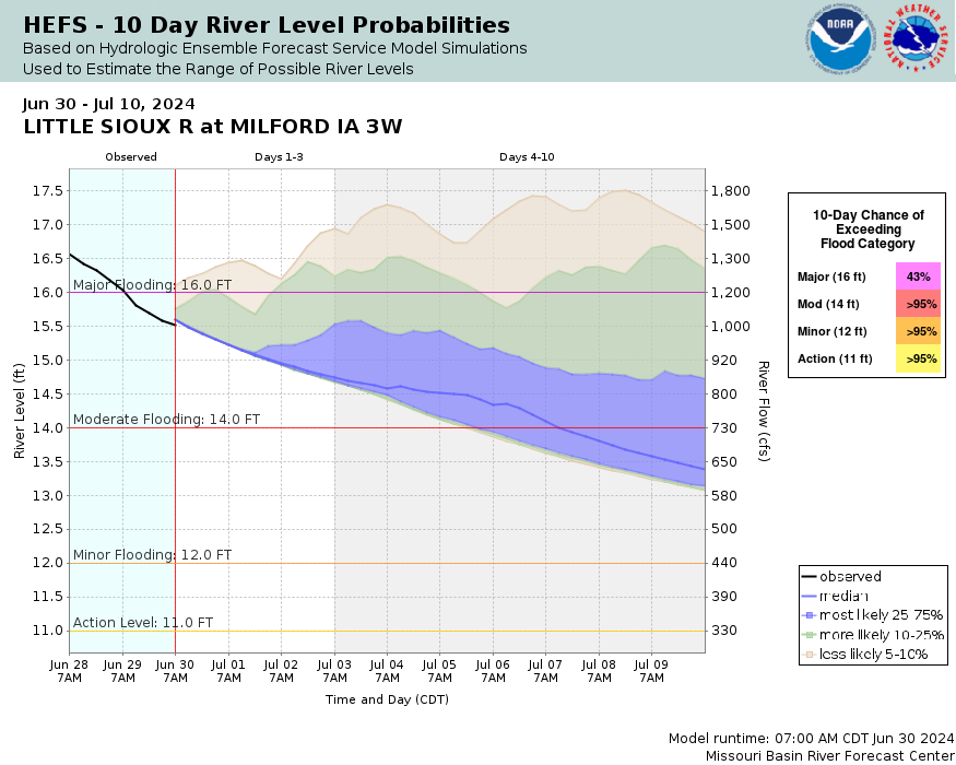
Little Sioux River near Milford
Future / Actual / Minor
OWP 2.0 WWA Modal Title
01/11/2021, 10:04 PM UTC through 01/11/2021, 10:04 PM UTC
Sender
Sent
- Gauge out of service.
Official
CATEGORY STAGE 
Major Flooding 20 ft Moderate Flooding 16 ft Minor Flooding 13 ft Action 11 ft - Gauge out of service.
National Water Model Hydrograph
Official NWS streamflow forecasts are produced by NWS hydrologic forecasters for river gauge locations using hydrologic models which are calibrated to that location. This process considers additional guidance and information, including local expertise and experience, to produce the best forecast possible. The NWM output provides supplemental guidance to NWS forecasters and should not be considered an official NWS river forecast.
Flood Impacts
- 22.5 - The bridge on 190th is overtopped and water reaches the bottom the bridge on 170th Ave.
- 20.5 - Water reaches the bottom of the bridge on 190th St.
- 17.5 - The floodplain can be as wide as 0.25 mile wide in places.
- 16.5 - The lowest portion of 180th St is flooded and water approaches the lowest portion of 190th Ave between 260th and 270th Streets in far southern Dickinson county.
- 13 - Flooding of agricultural and pasture land begins.
Gauge Info
| Coordinates | 43.3278, -95.2017 |
| RFC | MBRFC |
| State | IA |
| WFO | FSD |
| County | Dickinson |
| Data Provider(s) | |
| Iowa Flood Center | Iowa Flood Center |
Gauge Location
Recent Crests
| 1. | 20.40 ft | on 06-22-2024 |
| 2. | 13.59 ft | on 04-05-2023 |
| 3. | 15.19 ft | on 03-09-2020 |
| 4. | 18.02 ft | on 03-18-2019 |
| 5. | 20.10 ft | on 06-25-2018 |
Recent Crests
| 1. | 20.40 ft | on 06-22-2024 |
| 2. | 13.59 ft | on 04-05-2023 |
| 3. | 15.19 ft | on 03-09-2020 |
| 4. | 18.02 ft | on 03-18-2019 |
| 5. | 20.10 ft | on 06-25-2018 |
| 6. | 12.50 ft | on 05-24-2017 |
| 7. | 14.00 ft | on 05-03-2016 |
| 8. | 17.37 ft | on 06-19-2014 |
| 9. | 13.70 ft | on 05-31-2012 |
| 10. | 17.50 ft | on 07-15-2011 |
| 11. | 16.65 ft | on 03-17-2010 |
| 12. | 16.84 ft | on 08-23-2007 |
| 13. | 15.91 ft | on 04-09-2006 |
| 14. | 15.25 ft | on 06-14-2001 |
| 15. | 14.28 ft | on 03-24-1997 |
| 16. | 12.80 ft | on 03-31-1996 |
| 17. | 13.95 ft | on 03-01-1982 |
Historic Crests
| 1. | 20.40 ft | on 06-22-2024 |
| 2. | 20.10 ft | on 06-25-2018 |
| 3. | 18.02 ft | on 03-18-2019 |
| 4. | 17.50 ft | on 07-15-2011 |
| 5. | 17.37 ft | on 06-19-2014 |
Historic Crests
| 1. | 20.40 ft | on 06-22-2024 |
| 2. | 20.10 ft | on 06-25-2018 |
| 3. | 18.02 ft | on 03-18-2019 |
| 4. | 17.50 ft | on 07-15-2011 |
| 5. | 17.37 ft | on 06-19-2014 |
| 6. | 16.84 ft | on 08-23-2007 |
| 7. | 16.65 ft | on 03-17-2010 |
| 8. | 15.91 ft | on 04-09-2006 |
| 9. | 15.25 ft | on 06-14-2001 |
| 10. | 15.19 ft | on 03-09-2020 |
| 11. | 14.28 ft | on 03-24-1997 |
| 12. | 14.00 ft | on 05-03-2016 |
| 13. | 13.95 ft | on 03-01-1982 |
| 14. | 13.70 ft | on 05-31-2012 |
| 15. | 13.59 ft | on 04-05-2023 |
| 16. | 12.80 ft | on 03-31-1996 |
| 17. | 12.50 ft | on 05-24-2017 |
Vertical Datum Table
| type | NGVD29 |
|---|---|
| major Flooding | 1376.49 ft |
| moderate Flooding | 1372.49 ft |
| minor Flooding | 1369.49 ft |
| action | 1367.49 ft |
| Latest Value | N/A |
| Gauge Zero | 1356.49 ft |


Collaborative Agencies
The National Weather Service prepares its forecasts and other services in collaboration with agencies like the US Geological Survey, US Bureau of Reclamation, US Army Corps of Engineers, Natural Resource Conservation Service, National Park Service, ALERT Users Group, Bureau of Indian Affairs, and many state and local emergency managers across the country. For details, please click here.
Resources
Hydrologic Resource Links
- River Forecast Centers
- NWS Sioux Falls Flooding Resource Page
- NOHRSC Snow Information
- USACE Missouri River Water Management
- USGS National Water Dashboard
- FEMA Flood Insurance Information
- South Dakota Flood Information System
- Iowa Flood Information System
- Missouri River Flood Information System
- Minnesota DNR
- Nebraska Real-Time Flood Forecasting
- ___