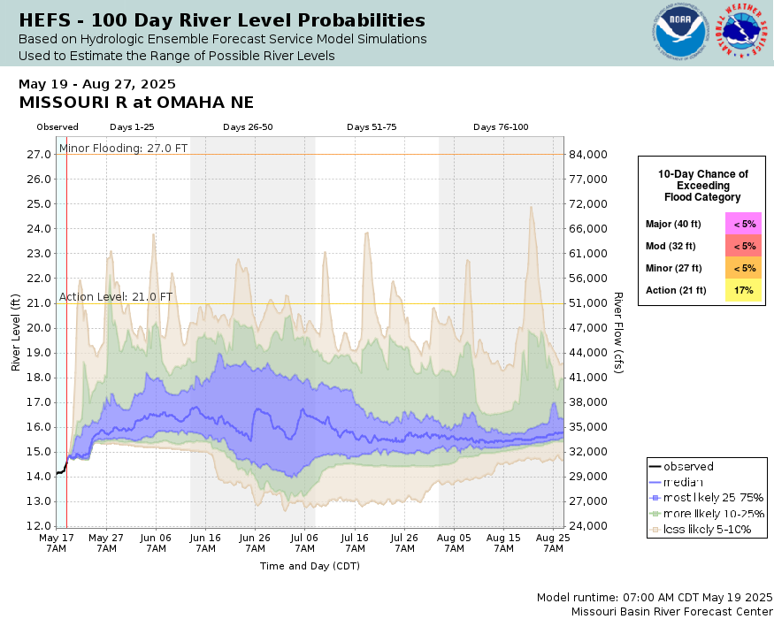
Missouri River at Omaha
Future / Actual / Minor
OWP 2.0 WWA Modal Title
01/11/2021, 10:04 PM UTC through 01/11/2021, 10:04 PM UTC
Sender
Sent
- Warning: no valid ratings curve available. Transformations to and from FEET/CFS/KCFS will not happen.
Traces and Thresholds Click to turn on/off display
Observed (OBS) 06/20/2025 11:00 PM CDTOfficial Forecast (FCST) 06/20/2025 9:13 AM CDTRecord: 40.2 ftLow Threshold: 9 ftCATEGORY STAGE 
Major Flooding 40 ft Moderate Flooding 32 ft Minor Flooding 27 ft Action 21 ft Reliability of the Forecast:
NOTE: Forecasts are issued routinely year-round.
River forecasts for this location take into account past precipitation and the precipitation amounts expected approximately 24 hours into the future from the forecast issuance time.
National Water Model Hydrograph
Official NWS streamflow forecasts are produced by NWS hydrologic forecasters for river gauge locations using hydrologic models which are calibrated to that location. This process considers additional guidance and information, including local expertise and experience, to produce the best forecast possible. The NWM output provides supplemental guidance to NWS forecasters and should not be considered an official NWS river forecast.
Flood Impacts
- 40 - At this level the water nears the top of the federal levee.
- 36 - Water reaches the bottom of flood wall just north of Interstate 480. Low lying roads are also affected just east of Riverfront Drive north of the pedestrian bridge.
- 32.5 - Floodwaters are reaching areas near Council Bluffs, specifically near Interstate 29, mile marker 56.
- 30.5 - Floodwaters are impacting Interstate 29/680 near Crescent and northward to exit 71 near Loveland.
- 29 - At this level water nears the base of the Council Bluffs levee. Significant lowland flooding occurs in NP Dodge Park, Freedom Park, Tom Hanafan Park, Fontenelle Forest and Haworth Park.
- 28 - At this level most of the flood gates for the city of Council Bluffs are closed.
- 27 - Freedom Park, Tom Hanafan River's Edge Park and Fontenelle Forest begin to flood.
- 25 - Haworth Park located in Bellevue begins to flood.
- 21 - At this level the City of Council Bluffs begins closing flood gates.
- 19 - At this level, the City of Council Bluffs begins to close drainage gates that discharge into the river.
Gauge Location
Recent Crests
| 1. | 32.77 ft | on 06-29-2024 |
| 2. | 16.55 ft | on 10-15-2023 |
| 3. | 15.54 ft | on 08-18-2022 |
| 4. | 16.06 ft | on 08-07-2021 |
| 5. | 21.93 ft | on 04-03-2020 |
Recent Crests
| 1. | 32.77 ft | on 06-29-2024 | |
| 2. | 16.55 ft | on 10-15-2023 | |
| 3. | 15.54 ft | on 08-18-2022 | |
| 4. | 16.06 ft | on 08-07-2021 | |
| 5. | 21.93 ft | on 04-03-2020 | |
| 6. | 30.58 ft | on 09-22-2019 | |
| 7. | 31.96 ft | on 06-05-2019 | |
| 8. | 34.40 ft | on 03-17-2019 | |
| 9. | 28.92 ft | on 06-29-2018 | |
| 10. | 22.43 ft | on 05-21-2017 | |
| 11. | 22.91 ft | on 05-01-2016 | |
| 12. | 21.86 ft | on 12-15-2015 | |
| 13. | 27.94 ft | on 06-23-2014 | |
| 14. | 23.97 ft | on 05-29-2013 | |
| 15. | 18.82 ft | on 06-02-2012 | |
| 16. | 36.29 ft | on 07-02-2011 | |
| 17. | 28.74 ft | on 07-01-2010 | |
| 18. | 21.50 ft | on 07-11-2009 | |
| 19. | 26.71 ft | on 06-12-2008 | |
| 20. | 26.52 ft | on 05-06-2007 | |
| 21. | 19.18 ft | on 04-13-2006 | |
| 22. | 19.96 ft | on 06-10-2005 | |
| 23. | 22.57 ft | on 06-18-2004 | |
| 24. | 22.07 ft | on 06-11-2003 | |
| 25. | 18.85 ft | on 06-12-2002 | |
| 26. | 23.52 ft | on 05-03-2001 | |
| 27. | 21.13 ft | on 06-27-2000 | |
| 28. | 24.22 ft | on 06-29-1999 | |
| 29. | 22.66 ft | on 06-16-1998 | |
| 30. | 26.48 ft | on 04-12-1997 | |
| 31. | 29.50 ft | on 06-23-1996 | |
| 32. | 26.31 ft | on 06-03-1995 | |
| 33. | 22.79 ft | on 06-27-1994 | |
| 34. | 30.26 ft | on 07-10-1993 | |
| 35. | 21.21 ft | on 07-15-1992 | |
| 36. | 25.37 ft | on 06-15-1991 | |
| 37. | 26.89 ft | on 06-17-1990 | |
| 38. | 21.19 ft | on 09-08-1989 | |
| 39. | 19.23 ft | on 06-08-1988 | |
| 40. | 22.57 ft | on 10-12-1986 | |
| 41. | 23.71 ft | on 04-29-1986 | |
| 42. | 22.63 ft | on 03-19-1986 | |
| 43. | 22.98 ft | on 04-24-1985 | |
| 44. | 29.02 ft | on 06-27-1984 | |
| 45. | 25.94 ft | on 06-30-1983 | |
| 46. | 22.41 ft | on 03-08-1983 | |
| 47. | 21.24 ft | on 05-29-1982 | |
| 48. | 19.68 ft | on 06-16-1981 | |
| 49. | 20.38 ft | on 06-15-1980 | |
| 50. | 19.07 ft | on 11-01-1979 | |
| 51. | 23.26 ft | on 03-19-1979 | |
| 52. | 24.38 ft | on 03-20-1978 | |
| 53. | 24.19 ft | on 03-19-1978 | |
| 54. | 20.37 ft | on 08-31-1977 | |
| 55. | 20.98 ft | on 11-21-1975 | |
| 56. | 21.83 ft | on 10-02-1975 | |
| 57. | 23.66 ft | on 08-18-1975 | |
| 58. | 20.86 ft | on 05-19-1974 | |
| 59. | 21.14 ft | on 09-26-1973 | |
| 60. | 19.28 ft | on 11-03-1972 | |
| 61. | 22.57 ft | on 09-11-1972 | |
| 62. | 22.64 ft | on 07-18-1972 | |
| 63. | 24.08 ft | on 06-11-1971 | |
| 64. | 23.94 ft | on 03-14-1971 | |
| 65. | 20.33 ft | on 08-02-1970 | |
| 66. | 19.88 ft | on 10-01-1969 | |
| 67. | 26.82 ft | on 04-12-1969 | |
| 68. | 20.39 ft | on 06-25-1968 | |
| 69. | 23.98 ft | on 01-19-1968 | |
| 70. | 24.03 ft | on 06-16-1967 | |
| 71. | 20.69 ft | on 02-10-1966 | |
| 72. | 21.82 ft | on 04-08-1965 | |
| 73. | 21.10 ft | on 05-26-1964 | |
| 74. | 19.97 ft | on 06-05-1963 | |
| 75. | 26.48 ft | on 03-29-1962 | |
| 76. | 17.66 ft | on 06-15-1961 | |
| 77. | 26.96 ft | on 04-04-1960 | |
| 78. | 40.20 ft | on 04-18-1952 | 1 |
| 79. | 34.22 ft | on 04-25-1881 | 1 |
Historic Crests
| 1. | 40.20 ft | on 04-18-1952 | 1 |
| 2. | 36.29 ft | on 07-02-2011 | |
| 3. | 34.40 ft | on 03-17-2019 | |
| 4. | 34.22 ft | on 04-25-1881 | 1 |
| 5. | 32.77 ft | on 06-29-2024 |
Historic Crests
| 1. | 40.20 ft | on 04-18-1952 | 1 |
| 2. | 36.29 ft | on 07-02-2011 | |
| 3. | 34.40 ft | on 03-17-2019 | |
| 4. | 34.22 ft | on 04-25-1881 | 1 |
| 5. | 32.77 ft | on 06-29-2024 | |
| 6. | 31.96 ft | on 06-05-2019 | |
| 7. | 30.58 ft | on 09-22-2019 | |
| 8. | 30.26 ft | on 07-10-1993 | |
| 9. | 29.50 ft | on 06-23-1996 | |
| 10. | 29.02 ft | on 06-27-1984 | |
| 11. | 28.92 ft | on 06-29-2018 | |
| 12. | 28.74 ft | on 07-01-2010 | |
| 13. | 27.94 ft | on 06-23-2014 | |
| 14. | 26.96 ft | on 04-04-1960 | |
| 15. | 26.89 ft | on 06-17-1990 | |
| 16. | 26.82 ft | on 04-12-1969 | |
| 17. | 26.71 ft | on 06-12-2008 | |
| 18. | 26.52 ft | on 05-06-2007 | |
| 19. | 26.48 ft | on 03-29-1962 | |
| 20. | 26.48 ft | on 04-12-1997 | |
| 21. | 26.31 ft | on 06-03-1995 | |
| 22. | 25.94 ft | on 06-30-1983 | |
| 23. | 25.37 ft | on 06-15-1991 | |
| 24. | 24.38 ft | on 03-20-1978 | |
| 25. | 24.22 ft | on 06-29-1999 | |
| 26. | 24.19 ft | on 03-19-1978 | |
| 27. | 24.08 ft | on 06-11-1971 | |
| 28. | 24.03 ft | on 06-16-1967 | |
| 29. | 23.98 ft | on 01-19-1968 | |
| 30. | 23.97 ft | on 05-29-2013 | |
| 31. | 23.94 ft | on 03-14-1971 | |
| 32. | 23.71 ft | on 04-29-1986 | |
| 33. | 23.66 ft | on 08-18-1975 | |
| 34. | 23.52 ft | on 05-03-2001 | |
| 35. | 23.26 ft | on 03-19-1979 | |
| 36. | 22.98 ft | on 04-24-1985 | |
| 37. | 22.91 ft | on 05-01-2016 | |
| 38. | 22.79 ft | on 06-27-1994 | |
| 39. | 22.66 ft | on 06-16-1998 | |
| 40. | 22.64 ft | on 07-18-1972 | |
| 41. | 22.63 ft | on 03-19-1986 | |
| 42. | 22.57 ft | on 09-11-1972 | |
| 43. | 22.57 ft | on 10-12-1986 | |
| 44. | 22.57 ft | on 06-18-2004 | |
| 45. | 22.43 ft | on 05-21-2017 | |
| 46. | 22.41 ft | on 03-08-1983 | |
| 47. | 22.07 ft | on 06-11-2003 | |
| 48. | 21.93 ft | on 04-03-2020 | |
| 49. | 21.86 ft | on 12-15-2015 | |
| 50. | 21.83 ft | on 10-02-1975 | |
| 51. | 21.82 ft | on 04-08-1965 | |
| 52. | 21.50 ft | on 07-11-2009 | |
| 53. | 21.24 ft | on 05-29-1982 | |
| 54. | 21.21 ft | on 07-15-1992 | |
| 55. | 21.19 ft | on 09-08-1989 | |
| 56. | 21.14 ft | on 09-26-1973 | |
| 57. | 21.13 ft | on 06-27-2000 | |
| 58. | 21.10 ft | on 05-26-1964 | |
| 59. | 20.98 ft | on 11-21-1975 | |
| 60. | 20.86 ft | on 05-19-1974 | |
| 61. | 20.69 ft | on 02-10-1966 | |
| 62. | 20.39 ft | on 06-25-1968 | |
| 63. | 20.38 ft | on 06-15-1980 | |
| 64. | 20.37 ft | on 08-31-1977 | |
| 65. | 20.33 ft | on 08-02-1970 | |
| 66. | 19.97 ft | on 06-05-1963 | |
| 67. | 19.96 ft | on 06-10-2005 | |
| 68. | 19.88 ft | on 10-01-1969 | |
| 69. | 19.68 ft | on 06-16-1981 | |
| 70. | 19.28 ft | on 11-03-1972 | |
| 71. | 19.23 ft | on 06-08-1988 | |
| 72. | 19.18 ft | on 04-13-2006 | |
| 73. | 19.07 ft | on 11-01-1979 | |
| 74. | 18.85 ft | on 06-12-2002 | |
| 75. | 18.82 ft | on 06-02-2012 | |
| 76. | 17.66 ft | on 06-15-1961 | |
| 77. | 16.55 ft | on 10-15-2023 | |
| 78. | 16.06 ft | on 08-07-2021 | |
| 79. | 15.54 ft | on 08-18-2022 |
Low Water Records
| 1. | 3.87 ft | on 01-16-2024 |
| 2. | 4.09 ft | on 12-24-2022 |
| 3. | 6.63 ft | on 01-01-2014 |
| 4. | 6.64 ft | on 02-03-2013 |
| 5. | 6.80 ft | on 01-21-2025 |
Low Water Records
| 1. | 3.87 ft | on 01-16-2024 |
| 2. | 4.09 ft | on 12-24-2022 |
| 3. | 6.63 ft | on 01-01-2014 |
| 4. | 6.64 ft | on 02-03-2013 |
| 5. | 6.80 ft | on 01-21-2025 |
| 6. | 6.85 ft | on 02-05-1989 |
| 7. | 7.23 ft | on 01-10-1957 |
| 8. | 7.98 ft | on 12-14-1961 |
| 9. | 8.15 ft | on 01-12-1982 |
| 10. | 8.23 ft | on 12-17-1989 |
| 11. | 8.24 ft | on 12-22-1990 |
| 12. | 8.80 ft | on 12-18-1964 |
| 13. | 9.03 ft | on 12-13-1962 |
| 14. | 9.63 ft | on 12-21-1960 |
| 15. | 10.00 ft | on 02-11-1981 |
| 16. | 10.00 ft | on 01-23-1985 |
| 17. | 10.02 ft | on 01-10-1967 |
| 18. | 10.12 ft | on 01-09-1976 |
| 19. | 10.17 ft | on 01-28-1978 |
| 20. | 10.83 ft | on 12-11-1963 |
| 21. | 10.89 ft | on 01-07-1988 |
| 22. | 11.30 ft | on 01-14-1975 |
| 23. | 11.57 ft | on 01-18-1972 |
| 24. | 11.75 ft | on 12-27-1985 |
| 25. | 12.00 ft | on 01-10-1980 |
| 26. | 12.24 ft | on 12-24-1967 |
| 27. | 12.48 ft | on 03-07-1966 |
| 28. | 12.58 ft | on 12-24-1983 |
| 29. | 12.62 ft | on 03-07-1977 |
| 30. | 12.75 ft | on 01-14-1979 |
| 31. | 12.88 ft | on 12-21-1972 |
| 32. | 13.20 ft | on 01-12-1974 |
| 33. | 13.20 ft | on 01-11-1974 |
| 34. | 14.08 ft | on 01-18-1983 |
| 35. | 14.64 ft | on 01-27-1987 |
Vertical Datum Table
| type | NAVD88 |
|---|---|
| major Flooding | 988.97 ft |
| moderate Flooding | 980.97 ft |
| minor Flooding | 975.97 ft |
| action | 969.97 ft |
| Latest Value | 964.09 ft |
| Gauge Zero | 948.97 ft |


Unique Local Info
The April 25, 1881 crest was read at the old Union Pacific Railroad bridge, located about 0.5 miles downstream of the current site. Elevation of reading is NGVD 1929 datum. The 1881 value at the datum then is use is available here.
How low can the river get?

Collaborative Agencies
The National Weather Service prepares its forecasts and other services in collaboration with agencies like the US Geological Survey, US Bureau of Reclamation, US Army Corps of Engineers, Natural Resource Conservation Service, National Park Service, ALERT Users Group, Bureau of Indian Affairs, and many state and local emergency managers across the country. For details, please click here.