Arkansas River at Ozark L/D Tailwater
Future / Actual / Minor
OWP 2.0 WWA Modal Title
01/11/2021, 10:04 PM UTC through 01/11/2021, 10:04 PM UTC
Sender
Sent
- Warning: no valid ratings curve available. Transformations to and from FEET/CFS/KCFS will not happen.
Traces and Thresholds Click to turn on/off display
Observed (OBS) 06/19/2025 9:00 AM CDTOfficial Forecast (FCST) 06/19/2025 8:50 AM CDTRecord: 375.5 ftCATEGORY STAGE 
Major Flooding 365 ft Moderate Flooding 363 ft Minor Flooding 357 ft Action 355.5 ft Reliability of the Forecast: Based on current and forecast river, weather and reservoir conditions
NOTE: Forecasts are issued routinely year-round.
River forecasts for this location take into account past precipitation and the precipitation amounts expected approximately 24 hours into the future from the forecast issuance time.
National Water Model Hydrograph
Official NWS streamflow forecasts are produced by NWS hydrologic forecasters for river gauge locations using hydrologic models which are calibrated to that location. This process considers additional guidance and information, including local expertise and experience, to produce the best forecast possible. The NWM output provides supplemental guidance to NWS forecasters and should not be considered an official NWS river forecast.
Flood Impacts
- 377 - this is the critical stage for the McLean Bottom Levee. The Highway 23 bridge approach is inundated in Ozark. Numerous roads near the river are impassable. This is an extremely dangerous and life threatening situation.
- 373 - this is the critical stage for the Lower Hartman Bottom Levee. Water covers lanes on the Highway 23 bridge approach in Ozark. Numerous roads near the river are impassable. This is an extremely dangerous and life threatening situation.
- 370 - this is the highest stage experienced since the completion of the navigation system in 1969. Highways 309 and 288 northwest of Paris in Logan County are inundated by backwater up Six Mile Creek. Backwater flooding spreads westward into Franklin County. This will exceed the December 29, 2015 flood when the river crested at 369.07 feet. This is an extremely dangerous and life threatening situation.
Gauge Info
| Coordinates | 35.4725, -93.8128 |
| RFC | ABRFC |
| State | AR |
| WFO | TSA |
| County | Franklin |
| Data Provider(s) | |
| US Army Corps of Engineers - LRD | Relevant - Ready - Responsive - Reliable |
| COE | Website |
Gauge Location
Recent Crests
| 1. | 359.18 ft | on 06-09-2025 |
| 2. | 359.70 ft | on 05-27-2025 |
| 3. | 355.68 ft | on 05-21-2025 |
| 4. | 358.17 ft | on 05-02-2025 |
| 5. | 355.22 ft | on 04-21-2025 |
Recent Crests
| 1. | 359.18 ft | on 06-09-2025 | |
| 2. | 359.70 ft | on 05-27-2025 | |
| 3. | 355.68 ft | on 05-21-2025 | |
| 4. | 358.17 ft | on 05-02-2025 | |
| 5. | 355.22 ft | on 04-21-2025 | |
| 6. | 359.14 ft | on 04-06-2025 | |
| 7. | 355.90 ft | on 11-05-2024 | |
| 8. | 357.49 ft | on 05-08-2024 | |
| 9. | 356.54 ft | on 05-04-2024 | |
| 10. | 357.59 ft | on 03-25-2023 | |
| 11. | 359.86 ft | on 06-11-2022 | |
| 12. | 358.49 ft | on 06-10-2022 | |
| 13. | 362.10 ft | on 05-07-2022 | |
| 14. | 355.62 ft | on 05-04-2022 | |
| 15. | 355.62 ft | on 04-25-2022 | |
| 16. | 355.80 ft | on 06-03-2021 | |
| 17. | 355.43 ft | on 05-29-2021 | |
| 18. | 362.78 ft | on 04-29-2021 | (P) |
| 19. | 359.72 ft | on 05-27-2020 | |
| 20. | 358.86 ft | on 05-17-2020 | (P) |
| 21. | 357.78 ft | on 04-04-2020 | (P) |
| 22. | 357.11 ft | on 03-31-2020 | |
| 23. | 359.47 ft | on 03-20-2020 | (P) |
| 24. | 357.32 ft | on 01-12-2020 | (P) |
| 25. | 356.34 ft | on 10-27-2019 | (P) |
| 26. | 357.02 ft | on 07-20-2019 | |
| 27. | 357.87 ft | on 07-03-2019 | |
| 28. | 361.99 ft | on 06-25-2019 | |
| 29. | 374.95 ft | on 06-02-2019 | (P) |
| 30. | 374.99 ft | on 05-30-2019 | (P) |
| 31. | 356.60 ft | on 05-13-2019 | |
| 32. | 356.42 ft | on 05-10-2019 | |
| 33. | 356.70 ft | on 05-02-2019 | |
| 34. | 355.59 ft | on 01-05-2019 | |
| 35. | 357.67 ft | on 02-25-2018 | |
| 36. | 360.79 ft | on 05-22-2017 | |
| 37. | 360.79 ft | on 05-21-2017 | |
| 38. | 358.81 ft | on 05-01-2017 | |
| 39. | 356.26 ft | on 04-27-2017 | |
| 40. | 369.07 ft | on 12-29-2015 | (P) |
| 41. | 357.86 ft | on 12-15-2015 | (P) |
| 42. | 358.35 ft | on 07-03-2015 | |
| 43. | 357.98 ft | on 06-20-2015 | |
| 44. | 357.82 ft | on 06-16-2015 | |
| 45. | 367.41 ft | on 06-01-2015 | |
| 46. | 367.71 ft | on 05-27-2015 | |
| 47. | 358.28 ft | on 05-21-2015 | |
| 48. | 363.77 ft | on 05-11-2015 | |
| 49. | 363.03 ft | on 04-26-2011 | |
| 50. | 358.00 ft | on 05-07-2009 | |
| 51. | 363.20 ft | on 04-11-2008 | |
| 52. | 362.07 ft | on 03-20-2008 | |
| 53. | 357.65 ft | on 03-21-2002 | |
| 54. | 355.15 ft | on 02-17-2001 | |
| 55. | 357.91 ft | on 03-22-2000 | |
| 56. | 356.46 ft | on 05-19-1999 | |
| 57. | 356.41 ft | on 03-21-1998 | |
| 58. | 361.31 ft | on 01-06-1998 | |
| 59. | 356.34 ft | on 02-22-1997 | |
| 60. | 364.00 ft | on 06-15-1995 | |
| 61. | 355.20 ft | on 05-15-1994 | |
| 62. | 363.70 ft | on 05-12-1993 | |
| 63. | 361.50 ft | on 12-16-1992 | |
| 64. | 358.30 ft | on 12-22-1991 | |
| 65. | 370.00 ft | on 05-06-1990 | |
| 66. | 368.50 ft | on 10-09-1986 | |
| 67. | 366.30 ft | on 11-25-1973 | |
| 68. | 375.50 ft | on 05-13-1943 | 1 |
Historic Crests
| 1. | 375.50 ft | on 05-13-1943 | 1 |
| 2. | 374.99 ft | on 05-30-2019 | (P) |
| 3. | 374.95 ft | on 06-02-2019 | (P) |
| 4. | 370.00 ft | on 05-06-1990 | |
| 5. | 369.07 ft | on 12-29-2015 | (P) |
Historic Crests
| 1. | 375.50 ft | on 05-13-1943 | 1 |
| 2. | 374.99 ft | on 05-30-2019 | (P) |
| 3. | 374.95 ft | on 06-02-2019 | (P) |
| 4. | 370.00 ft | on 05-06-1990 | |
| 5. | 369.07 ft | on 12-29-2015 | (P) |
| 6. | 368.50 ft | on 10-09-1986 | |
| 7. | 367.71 ft | on 05-27-2015 | |
| 8. | 367.41 ft | on 06-01-2015 | |
| 9. | 366.30 ft | on 11-25-1973 | |
| 10. | 364.00 ft | on 06-15-1995 | |
| 11. | 363.77 ft | on 05-11-2015 | |
| 12. | 363.70 ft | on 05-12-1993 | |
| 13. | 363.20 ft | on 04-11-2008 | |
| 14. | 363.03 ft | on 04-26-2011 | |
| 15. | 362.78 ft | on 04-29-2021 | (P) |
| 16. | 362.10 ft | on 05-07-2022 | |
| 17. | 362.07 ft | on 03-20-2008 | |
| 18. | 361.99 ft | on 06-25-2019 | |
| 19. | 361.50 ft | on 12-16-1992 | |
| 20. | 361.31 ft | on 01-06-1998 | |
| 21. | 360.79 ft | on 05-21-2017 | |
| 22. | 360.79 ft | on 05-22-2017 | |
| 23. | 359.86 ft | on 06-11-2022 | |
| 24. | 359.72 ft | on 05-27-2020 | |
| 25. | 359.70 ft | on 05-27-2025 | |
| 26. | 359.47 ft | on 03-20-2020 | (P) |
| 27. | 359.18 ft | on 06-09-2025 | |
| 28. | 359.14 ft | on 04-06-2025 | |
| 29. | 358.86 ft | on 05-17-2020 | (P) |
| 30. | 358.81 ft | on 05-01-2017 | |
| 31. | 358.49 ft | on 06-10-2022 | |
| 32. | 358.35 ft | on 07-03-2015 | |
| 33. | 358.30 ft | on 12-22-1991 | |
| 34. | 358.28 ft | on 05-21-2015 | |
| 35. | 358.17 ft | on 05-02-2025 | |
| 36. | 358.00 ft | on 05-07-2009 | |
| 37. | 357.98 ft | on 06-20-2015 | |
| 38. | 357.91 ft | on 03-22-2000 | |
| 39. | 357.87 ft | on 07-03-2019 | |
| 40. | 357.86 ft | on 12-15-2015 | (P) |
| 41. | 357.82 ft | on 06-16-2015 | |
| 42. | 357.78 ft | on 04-04-2020 | (P) |
| 43. | 357.67 ft | on 02-25-2018 | |
| 44. | 357.65 ft | on 03-21-2002 | |
| 45. | 357.59 ft | on 03-25-2023 | |
| 46. | 357.49 ft | on 05-08-2024 | |
| 47. | 357.32 ft | on 01-12-2020 | (P) |
| 48. | 357.11 ft | on 03-31-2020 | |
| 49. | 357.02 ft | on 07-20-2019 | |
| 50. | 356.70 ft | on 05-02-2019 | |
| 51. | 356.60 ft | on 05-13-2019 | |
| 52. | 356.54 ft | on 05-04-2024 | |
| 53. | 356.46 ft | on 05-19-1999 | |
| 54. | 356.42 ft | on 05-10-2019 | |
| 55. | 356.41 ft | on 03-21-1998 | |
| 56. | 356.34 ft | on 02-22-1997 | |
| 57. | 356.34 ft | on 10-27-2019 | (P) |
| 58. | 356.26 ft | on 04-27-2017 | |
| 59. | 355.90 ft | on 11-05-2024 | |
| 60. | 355.80 ft | on 06-03-2021 | |
| 61. | 355.68 ft | on 05-21-2025 | |
| 62. | 355.62 ft | on 05-04-2022 | |
| 63. | 355.62 ft | on 04-25-2022 | |
| 64. | 355.59 ft | on 01-05-2019 | |
| 65. | 355.43 ft | on 05-29-2021 | |
| 66. | 355.22 ft | on 04-21-2025 | |
| 67. | 355.20 ft | on 05-15-1994 | |
| 68. | 355.15 ft | on 02-17-2001 |
Vertical Datum Table
| type | NGVD29 |
|---|---|
| major Flooding | 365.00 ft |
| moderate Flooding | 363.00 ft |
| minor Flooding | 357.00 ft |
| action | 355.50 ft |
| Latest Value | 355.85 ft |
| Gauge Zero | 0.00 ft |


Unique Local Info
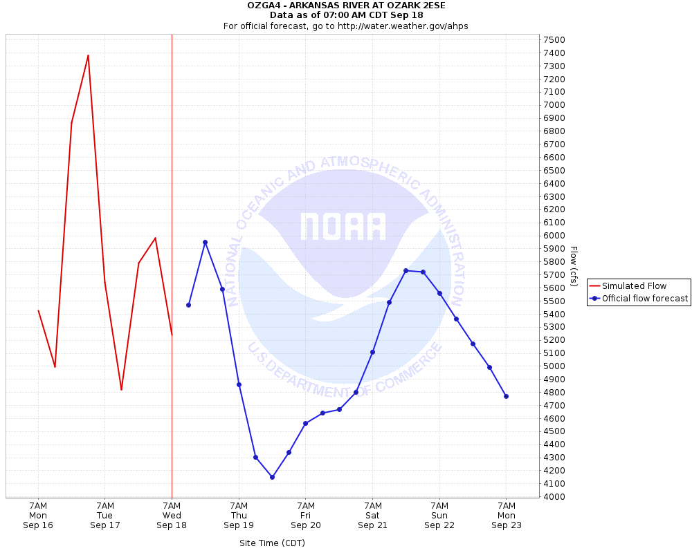
River flow forecast can be found at the following link: http://www.weather.gov/images/abrfc/lwr_ark/OZARK_2ESE_QT.gif
Collaborative Agencies
The National Weather Service prepares its forecasts and other services in collaboration with agencies like the US Geological Survey, US Bureau of Reclamation, US Army Corps of Engineers, Natural Resource Conservation Service, National Park Service, ALERT Users Group, Bureau of Indian Affairs, and many state and local emergency managers across the country. For details, please click here.