Pee Dee River at Pee Dee
Future / Actual / Minor
OWP 2.0 WWA Modal Title
01/11/2021, 10:04 PM UTC through 01/11/2021, 10:04 PM UTC
Sender
Sent
- Warning: no valid ratings curve available. Transformations to and from FEET/CFS/KCFS will not happen.
Traces and Thresholds Click to turn on/off display
Observed (OBS) 06/24/2025 6:00 AM EDTOfficial Forecast (FCST) 06/23/2025 8:51 AM EDTRecord: 33.3 ftCATEGORY STAGE 
Major Flooding 28 ft Moderate Flooding 23 ft Minor Flooding 19 ft Action 18 ft Reliability of the Forecast:
NOTE: Forecasts are issued routinely year-round.
River forecasts for this location take into account past precipitation and the precipitation amounts expected approximately 48 hours into the future from the forecast issuance time.
National Water Model Hydrograph
Official NWS streamflow forecasts are produced by NWS hydrologic forecasters for river gauge locations using hydrologic models which are calibrated to that location. This process considers additional guidance and information, including local expertise and experience, to produce the best forecast possible. The NWM output provides supplemental guidance to NWS forecasters and should not be considered an official NWS river forecast.
Flood Impacts
- 28 - There will be extensive flooding of timber land and farm land along the river. Access roads may be damaged by the flood waters and operations at industrial plants along the river will be affected.
- 25 - Flood waters will continue to affect logging operations upstream and downstream from Pee Dee. Flooding of farmlands adjacent to the river will worsen.
- 23 - Flooding will affect swamp and timberlands while also disrupting logging operations. Operations will likely cease and equipment not previously moved will remain trapped. Some farmland will have minor flooding especially around Britton Neck.
Gauge Info
| Coordinates | 34.2042, -79.5486 |
| RFC | SERFC |
| State | SC |
| WFO | ILM |
| County | Marion |
| Data Provider(s) | |
| US Geological Survey | USGS--Water Resources of the United States |
| USGS | 02131000 |
Gauge Location
Recent Crests
| 1. | 23.11 ft | on 10-04-2024 |
| 2. | 18.99 ft | on 09-21-2024 |
| 3. | 24.90 ft | on 08-14-2024 |
| 4. | 21.38 ft | on 05-20-2024 |
| 5. | 19.06 ft | on 05-12-2024 |
Recent Crests
| 1. | 23.11 ft | on 10-04-2024 |
| 2. | 18.99 ft | on 09-21-2024 |
| 3. | 24.90 ft | on 08-14-2024 |
| 4. | 21.38 ft | on 05-20-2024 |
| 5. | 19.06 ft | on 05-12-2024 |
| 6. | 20.52 ft | on 04-01-2024 |
| 7. | 20.59 ft | on 03-14-2024 |
| 8. | 21.85 ft | on 02-02-2024 |
| 9. | 26.30 ft | on 01-17-2024 |
| 10. | 21.60 ft | on 01-01-2024 |
| 11. | 18.74 ft | on 12-20-2023 |
| 12. | 19.69 ft | on 06-26-2023 |
| 13. | 19.85 ft | on 05-04-2023 |
| 14. | 22.52 ft | on 04-14-2023 |
| 15. | 21.34 ft | on 02-17-2023 |
| 16. | 19.03 ft | on 02-06-2023 |
| 17. | 19.99 ft | on 01-29-2023 |
| 18. | 18.36 ft | on 12-26-2022 |
| 19. | 19.27 ft | on 04-10-2022 |
| 20. | 21.99 ft | on 03-21-2022 |
| 21. | 19.37 ft | on 01-06-2022 |
| 22. | 22.65 ft | on 04-02-2021 |
| 23. | 19.91 ft | on 03-23-2021 |
| 24. | 26.41 ft | on 02-21-2021 |
| 25. | 21.82 ft | on 02-05-2021 |
| 26. | 22.59 ft | on 01-08-2021 |
| 27. | 21.37 ft | on 12-21-2020 |
| 28. | 20.56 ft | on 12-05-2020 |
| 29. | 27.85 ft | on 11-18-2020 |
| 30. | 20.05 ft | on 11-04-2020 |
| 31. | 21.57 ft | on 10-17-2020 |
| 32. | 19.29 ft | on 09-29-2020 |
| 33. | 18.91 ft | on 08-24-2020 |
| 34. | 20.20 ft | on 08-20-2020 |
| 35. | 27.89 ft | on 05-27-2020 |
| 36. | 20.69 ft | on 05-05-2020 |
| 37. | 20.40 ft | on 03-30-2020 |
| 38. | 18.57 ft | on 03-09-2020 |
| 39. | 29.11 ft | on 02-12-2020 |
| 40. | 20.81 ft | on 01-29-2020 |
| 41. | 21.91 ft | on 01-19-2020 |
| 42. | 20.25 ft | on 01-08-2020 |
| 43. | 20.39 ft | on 12-27-2019 |
| 44. | 20.82 ft | on 12-19-2019 |
| 45. | 22.38 ft | on 04-19-2019 |
| 46. | 25.75 ft | on 03-01-2019 |
| 47. | 22.44 ft | on 01-30-2019 |
| 48. | 20.89 ft | on 01-24-2019 |
| 49. | 21.17 ft | on 01-17-2019 |
| 50. | 23.54 ft | on 01-09-2019 |
| 51. | 24.06 ft | on 01-04-2019 |
| 52. | 25.60 ft | on 12-26-2018 |
| 53. | 24.45 ft | on 12-21-2018 |
| 54. | 22.86 ft | on 12-16-2018 |
| 55. | 27.16 ft | on 11-20-2018 |
| 56. | 20.69 ft | on 10-31-2018 |
| 57. | 25.21 ft | on 10-18-2018 |
| 58. | 31.83 ft | on 09-21-2018 |
| 59. | 19.20 ft | on 02-15-2018 |
| 60. | 18.18 ft | on 06-08-2017 |
| 61. | 21.38 ft | on 05-30-2017 |
| 62. | 23.64 ft | on 05-02-2017 |
| 63. | 20.44 ft | on 01-28-2017 |
| 64. | 23.14 ft | on 10-13-2016 |
| 65. | 18.83 ft | on 05-07-2016 |
| 66. | 26.82 ft | on 01-05-2016 |
| 67. | 26.61 ft | on 12-29-2015 |
| 68. | 23.57 ft | on 11-25-2015 |
| 69. | 24.00 ft | on 11-16-2015 |
| 70. | 23.00 ft | on 11-09-2015 |
| 71. | 22.81 ft | on 10-09-2015 |
| 72. | 21.66 ft | on 04-26-2015 |
| 73. | 19.15 ft | on 03-03-2015 |
| 74. | 19.11 ft | on 01-16-2015 |
| 75. | 19.30 ft | on 12-27-2014 |
| 76. | 22.44 ft | on 04-24-2014 |
| 77. | 19.09 ft | on 04-11-2014 |
| 78. | 23.90 ft | on 03-14-2014 |
| 79. | 20.95 ft | on 02-24-2014 |
| 80. | 23.45 ft | on 01-18-2014 |
| 81. | 21.57 ft | on 01-03-2014 |
| 82. | 21.20 ft | on 12-29-2013 |
| 83. | 19.36 ft | on 08-24-2013 |
| 84. | 21.04 ft | on 08-02-2013 |
| 85. | 22.78 ft | on 07-12-2013 |
| 86. | 22.66 ft | on 07-10-2013 |
| 87. | 22.79 ft | on 06-14-2013 |
| 88. | 19.49 ft | on 05-03-2013 |
| 89. | 19.31 ft | on 03-03-2013 |
| 90. | 21.12 ft | on 01-24-2013 |
| 91. | 20.02 ft | on 05-20-2012 |
| 92. | 17.73 ft | on 03-13-2011 |
| 93. | 18.43 ft | on 10-03-2010 |
| 94. | 19.85 ft | on 04-03-2010 |
| 95. | 19.23 ft | on 03-17-2010 |
| 96. | 26.53 ft | on 02-11-2010 |
| 97. | 25.31 ft | on 02-01-2010 |
| 98. | 19.36 ft | on 01-22-2010 |
| 99. | 22.48 ft | on 01-01-2010 |
| 100. | 20.64 ft | on 12-14-2009 |
| 101. | 19.02 ft | on 12-07-2009 |
| 102. | 21.18 ft | on 11-18-2009 |
| 103. | 20.30 ft | on 06-10-2009 |
| 104. | 18.80 ft | on 06-01-2009 |
| 105. | 18.60 ft | on 04-01-2009 |
| 106. | 21.83 ft | on 03-07-2009 |
| 107. | 19.70 ft | on 01-12-2009 |
| 108. | 19.40 ft | on 12-16-2008 |
| 109. | 18.70 ft | on 08-31-2008 |
| 110. | 19.63 ft | on 04-10-2008 |
| 111. | 20.01 ft | on 04-20-2007 |
| 112. | 23.02 ft | on 03-09-2007 |
| 113. | 19.06 ft | on 02-18-2007 |
| 114. | 22.18 ft | on 01-13-2007 |
| 115. | 20.30 ft | on 01-07-2007 |
| 116. | 20.60 ft | on 12-30-2006 |
| 117. | 24.72 ft | on 11-28-2006 |
| 118. | 19.75 ft | on 11-21-2006 |
| 119. | 19.19 ft | on 06-17-2006 |
| 120. | 19.48 ft | on 12-20-2005 |
| 121. | 20.02 ft | on 04-18-2005 |
| 122. | 21.50 ft | on 04-04-2005 |
| 123. | 19.43 ft | on 01-18-2005 |
| 124. | 23.77 ft | on 10-05-2004 |
| 125. | 24.86 ft | on 09-15-2004 |
| 126. | 21.44 ft | on 08-15-2003 |
| 127. | 20.80 ft | on 07-07-2003 |
| 128. | 22.95 ft | on 05-31-2003 |
| 129. | 20.57 ft | on 05-11-2003 |
| 130. | 29.48 ft | on 04-16-2003 |
| 131. | 27.80 ft | on 03-27-2003 |
| 132. | 22.90 ft | on 03-12-2003 |
| 133. | 22.20 ft | on 03-06-2003 |
| 134. | 20.34 ft | on 12-30-2002 |
| 135. | 20.14 ft | on 12-18-2002 |
| 136. | 19.73 ft | on 11-21-2002 |
| 137. | 17.28 ft | on 01-26-2002 |
| 138. | 19.40 ft | on 04-03-2001 |
| 139. | 20.18 ft | on 02-18-2000 |
| 140. | 21.11 ft | on 02-05-2000 |
| 141. | 19.33 ft | on 10-03-1999 |
| 142. | 19.27 ft | on 05-04-1999 |
| 143. | 21.48 ft | on 01-29-1999 |
| 144. | 19.80 ft | on 09-08-1998 |
| 145. | 20.58 ft | on 05-14-1998 |
| 146. | 23.10 ft | on 04-26-1998 |
| 147. | 20.88 ft | on 04-14-1998 |
| 148. | 25.54 ft | on 03-25-1998 |
| 149. | 23.28 ft | on 03-15-1998 |
| 150. | 24.22 ft | on 02-23-1998 |
| 151. | 25.34 ft | on 02-03-1998 |
| 152. | 23.69 ft | on 01-24-1998 |
| 153. | 23.04 ft | on 01-14-1998 |
| 154. | 19.98 ft | on 12-29-1997 |
| 155. | 23.44 ft | on 07-31-1997 |
| 156. | 24.03 ft | on 05-06-1997 |
| 157. | 19.05 ft | on 03-18-1997 |
| 158. | 20.17 ft | on 03-05-1997 |
| 159. | 22.44 ft | on 02-20-1997 |
| 160. | 19.40 ft | on 10-12-1996 |
| 161. | 20.10 ft | on 09-10-1996 |
| 162. | 20.08 ft | on 03-11-1996 |
| 163. | 22.77 ft | on 02-08-1996 |
| 164. | 21.08 ft | on 01-31-1996 |
| 165. | 21.74 ft | on 11-17-1995 |
| 166. | 21.08 ft | on 10-10-1995 |
| 167. | 20.67 ft | on 09-02-1995 |
| 168. | 21.51 ft | on 03-06-1995 |
| 169. | 25.40 ft | on 02-24-1995 |
| 170. | 19.35 ft | on 02-01-1995 |
| 171. | 20.68 ft | on 12-27-1994 |
| 172. | 22.97 ft | on 03-09-1994 |
| 173. | 26.09 ft | on 04-01-1993 |
| 174. | 23.95 ft | on 04-30-1992 |
| 175. | 23.61 ft | on 04-06-1991 |
| 176. | 26.73 ft | on 10-30-1990 |
| 177. | 24.40 ft | on 10-19-1990 |
| 178. | 21.37 ft | on 06-04-1990 |
| 179. | 20.17 ft | on 04-05-1990 |
| 180. | 20.67 ft | on 03-07-1990 |
| 181. | 23.77 ft | on 02-25-1990 |
| 182. | 21.41 ft | on 02-16-1990 |
| 183. | 19.61 ft | on 01-30-1990 |
| 184. | 19.59 ft | on 01-13-1990 |
| 185. | 21.31 ft | on 12-18-1989 |
| 186. | 26.53 ft | on 10-09-1989 |
| 187. | 22.15 ft | on 05-14-1989 |
| 188. | 19.27 ft | on 04-13-1989 |
| 189. | 24.45 ft | on 03-31-1989 |
| 190. | 22.95 ft | on 03-09-1989 |
| 191. | 20.75 ft | on 02-28-1989 |
| 192. | 19.48 ft | on 01-24-1988 |
| 193. | 19.06 ft | on 09-16-1987 |
| 194. | 22.53 ft | on 05-02-1987 |
| 195. | 22.80 ft | on 04-23-1987 |
| 196. | 19.44 ft | on 04-04-1987 |
| 197. | 29.06 ft | on 03-07-1987 |
| 198. | 22.60 ft | on 01-27-1987 |
| 199. | 18.71 ft | on 08-23-1986 |
| 200. | 21.99 ft | on 12-07-1985 |
| 201. | 21.74 ft | on 08-29-1985 |
| 202. | 22.80 ft | on 04-06-1984 |
| 203. | 24.65 ft | on 03-25-1983 |
| 204. | 22.75 ft | on 01-09-1982 |
| 205. | 18.65 ft | on 02-14-1981 |
| 206. | 24.11 ft | on 04-03-1980 |
| 207. | 29.05 ft | on 03-02-1979 |
| 208. | 26.58 ft | on 02-01-1978 |
| 209. | 22.51 ft | on 04-06-1977 |
| 210. | 22.56 ft | on 12-20-1976 |
| 211. | 20.49 ft | on 06-26-1976 |
| 212. | 27.81 ft | on 03-20-1975 |
| 213. | 22.45 ft | on 04-12-1974 |
| 214. | 26.97 ft | on 04-06-1973 |
| 215. | 23.89 ft | on 06-29-1972 |
| 216. | 23.98 ft | on 03-10-1971 |
| 217. | 21.69 ft | on 08-19-1970 |
| 218. | 21.92 ft | on 02-27-1969 |
| 219. | 23.00 ft | on 01-19-1968 |
| 220. | 20.84 ft | on 08-29-1967 |
| 221. | 20.84 ft | on 04-29-1967 |
| 222. | 25.28 ft | on 03-10-1966 |
| 223. | 23.04 ft | on 03-25-1965 |
| 224. | 26.01 ft | on 10-23-1964 |
| 225. | 23.95 ft | on 04-14-1964 |
| 226. | 24.54 ft | on 03-20-1963 |
| 227. | 22.98 ft | on 01-14-1962 |
| 228. | 23.86 ft | on 03-03-1961 |
| 229. | 26.28 ft | on 04-10-1960 |
| 230. | 23.64 ft | on 10-20-1959 |
| 231. | 21.44 ft | on 04-26-1959 |
| 232. | 24.13 ft | on 05-05-1958 |
| 233. | 24.58 ft | on 12-01-1957 |
| 234. | 21.58 ft | on 04-13-1957 |
| 235. | 20.46 ft | on 03-22-1956 |
| 236. | 22.44 ft | on 04-21-1955 |
| 237. | 25.76 ft | on 01-29-1954 |
| 238. | 23.54 ft | on 02-28-1953 |
| 239. | 25.95 ft | on 03-10-1952 |
| 240. | 20.36 ft | on 04-14-1951 |
| 241. | 19.19 ft | on 05-19-1950 |
| 242. | 21.22 ft | on 11-07-1949 |
| 243. | 23.46 ft | on 05-08-1949 |
| 244. | 24.12 ft | on 12-05-1948 |
| 245. | 26.23 ft | on 02-19-1948 |
| 246. | 22.16 ft | on 01-26-1947 |
| 247. | 23.76 ft | on 01-04-1946 |
| 248. | 33.30 ft | on 09-22-1945 |
| 249. | 24.31 ft | on 03-26-1944 |
| 250. | 22.31 ft | on 02-03-1943 |
| 251. | 22.26 ft | on 03-15-1942 |
| 252. | 19.32 ft | on 04-09-1941 |
| 253. | 22.35 ft | on 08-22-1940 |
| 254. | 25.61 ft | on 03-06-1939 |
| 255. | 29.00 ft | on 04-11-1936 |
| 256. | 29.20 ft | on 10-07-1929 |
| 257. | 31.60 ft | on 09-23-1928 |
Historic Crests
| 1. | 33.30 ft | on 09-22-1945 |
| 2. | 31.83 ft | on 09-21-2018 |
| 3. | 31.60 ft | on 09-23-1928 |
| 4. | 29.48 ft | on 04-16-2003 |
| 5. | 29.20 ft | on 10-07-1929 |
Historic Crests
| 1. | 33.30 ft | on 09-22-1945 |
| 2. | 31.83 ft | on 09-21-2018 |
| 3. | 31.60 ft | on 09-23-1928 |
| 4. | 29.48 ft | on 04-16-2003 |
| 5. | 29.20 ft | on 10-07-1929 |
| 6. | 29.11 ft | on 02-12-2020 |
| 7. | 29.06 ft | on 03-07-1987 |
| 8. | 29.05 ft | on 03-02-1979 |
| 9. | 29.00 ft | on 04-11-1936 |
| 10. | 27.89 ft | on 05-27-2020 |
| 11. | 27.85 ft | on 11-18-2020 |
| 12. | 27.81 ft | on 03-20-1975 |
| 13. | 27.80 ft | on 03-27-2003 |
| 14. | 27.16 ft | on 11-20-2018 |
| 15. | 26.97 ft | on 04-06-1973 |
| 16. | 26.82 ft | on 01-05-2016 |
| 17. | 26.73 ft | on 10-30-1990 |
| 18. | 26.61 ft | on 12-29-2015 |
| 19. | 26.58 ft | on 02-01-1978 |
| 20. | 26.53 ft | on 10-09-1989 |
| 21. | 26.53 ft | on 02-11-2010 |
| 22. | 26.41 ft | on 02-21-2021 |
| 23. | 26.30 ft | on 01-17-2024 |
| 24. | 26.28 ft | on 04-10-1960 |
| 25. | 26.23 ft | on 02-19-1948 |
| 26. | 26.09 ft | on 04-01-1993 |
| 27. | 26.01 ft | on 10-23-1964 |
| 28. | 25.95 ft | on 03-10-1952 |
| 29. | 25.76 ft | on 01-29-1954 |
| 30. | 25.75 ft | on 03-01-2019 |
| 31. | 25.61 ft | on 03-06-1939 |
| 32. | 25.60 ft | on 12-26-2018 |
| 33. | 25.54 ft | on 03-25-1998 |
| 34. | 25.40 ft | on 02-24-1995 |
| 35. | 25.34 ft | on 02-03-1998 |
| 36. | 25.31 ft | on 02-01-2010 |
| 37. | 25.28 ft | on 03-10-1966 |
| 38. | 25.21 ft | on 10-18-2018 |
| 39. | 24.90 ft | on 08-14-2024 |
| 40. | 24.86 ft | on 09-15-2004 |
| 41. | 24.72 ft | on 11-28-2006 |
| 42. | 24.65 ft | on 03-25-1983 |
| 43. | 24.58 ft | on 12-01-1957 |
| 44. | 24.54 ft | on 03-20-1963 |
| 45. | 24.45 ft | on 12-21-2018 |
| 46. | 24.45 ft | on 03-31-1989 |
| 47. | 24.40 ft | on 10-19-1990 |
| 48. | 24.31 ft | on 03-26-1944 |
| 49. | 24.22 ft | on 02-23-1998 |
| 50. | 24.13 ft | on 05-05-1958 |
| 51. | 24.12 ft | on 12-05-1948 |
| 52. | 24.11 ft | on 04-03-1980 |
| 53. | 24.06 ft | on 01-04-2019 |
| 54. | 24.03 ft | on 05-06-1997 |
| 55. | 24.00 ft | on 11-16-2015 |
| 56. | 23.98 ft | on 03-10-1971 |
| 57. | 23.95 ft | on 04-30-1992 |
| 58. | 23.95 ft | on 04-14-1964 |
| 59. | 23.90 ft | on 03-14-2014 |
| 60. | 23.89 ft | on 06-29-1972 |
| 61. | 23.86 ft | on 03-03-1961 |
| 62. | 23.77 ft | on 02-25-1990 |
| 63. | 23.77 ft | on 10-05-2004 |
| 64. | 23.76 ft | on 01-04-1946 |
| 65. | 23.69 ft | on 01-24-1998 |
| 66. | 23.64 ft | on 10-20-1959 |
| 67. | 23.64 ft | on 05-02-2017 |
| 68. | 23.61 ft | on 04-06-1991 |
| 69. | 23.57 ft | on 11-25-2015 |
| 70. | 23.54 ft | on 02-28-1953 |
| 71. | 23.54 ft | on 01-09-2019 |
| 72. | 23.46 ft | on 05-08-1949 |
| 73. | 23.45 ft | on 01-18-2014 |
| 74. | 23.44 ft | on 07-31-1997 |
| 75. | 23.28 ft | on 03-15-1998 |
| 76. | 23.14 ft | on 10-13-2016 |
| 77. | 23.11 ft | on 10-04-2024 |
| 78. | 23.10 ft | on 04-26-1998 |
| 79. | 23.04 ft | on 01-14-1998 |
| 80. | 23.04 ft | on 03-25-1965 |
| 81. | 23.02 ft | on 03-09-2007 |
| 82. | 23.00 ft | on 11-09-2015 |
| 83. | 23.00 ft | on 01-19-1968 |
| 84. | 22.98 ft | on 01-14-1962 |
| 85. | 22.97 ft | on 03-09-1994 |
| 86. | 22.95 ft | on 05-31-2003 |
| 87. | 22.95 ft | on 03-09-1989 |
| 88. | 22.90 ft | on 03-12-2003 |
| 89. | 22.86 ft | on 12-16-2018 |
| 90. | 22.81 ft | on 10-09-2015 |
| 91. | 22.80 ft | on 04-23-1987 |
| 92. | 22.80 ft | on 04-06-1984 |
| 93. | 22.79 ft | on 06-14-2013 |
| 94. | 22.78 ft | on 07-12-2013 |
| 95. | 22.77 ft | on 02-08-1996 |
| 96. | 22.75 ft | on 01-09-1982 |
| 97. | 22.66 ft | on 07-10-2013 |
| 98. | 22.65 ft | on 04-02-2021 |
| 99. | 22.60 ft | on 01-27-1987 |
| 100. | 22.59 ft | on 01-08-2021 |
| 101. | 22.56 ft | on 12-20-1976 |
| 102. | 22.53 ft | on 05-02-1987 |
| 103. | 22.52 ft | on 04-14-2023 |
| 104. | 22.51 ft | on 04-06-1977 |
| 105. | 22.48 ft | on 01-01-2010 |
| 106. | 22.45 ft | on 04-12-1974 |
| 107. | 22.44 ft | on 02-20-1997 |
| 108. | 22.44 ft | on 01-30-2019 |
| 109. | 22.44 ft | on 04-24-2014 |
| 110. | 22.44 ft | on 04-21-1955 |
| 111. | 22.38 ft | on 04-19-2019 |
| 112. | 22.35 ft | on 08-22-1940 |
| 113. | 22.31 ft | on 02-03-1943 |
| 114. | 22.26 ft | on 03-15-1942 |
| 115. | 22.20 ft | on 03-06-2003 |
| 116. | 22.18 ft | on 01-13-2007 |
| 117. | 22.16 ft | on 01-26-1947 |
| 118. | 22.15 ft | on 05-14-1989 |
| 119. | 21.99 ft | on 12-07-1985 |
| 120. | 21.99 ft | on 03-21-2022 |
| 121. | 21.92 ft | on 02-27-1969 |
| 122. | 21.91 ft | on 01-19-2020 |
| 123. | 21.85 ft | on 02-02-2024 |
| 124. | 21.83 ft | on 03-07-2009 |
| 125. | 21.82 ft | on 02-05-2021 |
| 126. | 21.74 ft | on 11-17-1995 |
| 127. | 21.74 ft | on 08-29-1985 |
| 128. | 21.69 ft | on 08-19-1970 |
| 129. | 21.66 ft | on 04-26-2015 |
| 130. | 21.60 ft | on 01-01-2024 |
| 131. | 21.58 ft | on 04-13-1957 |
| 132. | 21.57 ft | on 10-17-2020 |
| 133. | 21.57 ft | on 01-03-2014 |
| 134. | 21.51 ft | on 03-06-1995 |
| 135. | 21.50 ft | on 04-04-2005 |
| 136. | 21.48 ft | on 01-29-1999 |
| 137. | 21.44 ft | on 08-15-2003 |
| 138. | 21.44 ft | on 04-26-1959 |
| 139. | 21.41 ft | on 02-16-1990 |
| 140. | 21.38 ft | on 05-30-2017 |
| 141. | 21.38 ft | on 05-20-2024 |
| 142. | 21.37 ft | on 12-21-2020 |
| 143. | 21.37 ft | on 06-04-1990 |
| 144. | 21.34 ft | on 02-17-2023 |
| 145. | 21.31 ft | on 12-18-1989 |
| 146. | 21.22 ft | on 11-07-1949 |
| 147. | 21.20 ft | on 12-29-2013 |
| 148. | 21.18 ft | on 11-18-2009 |
| 149. | 21.17 ft | on 01-17-2019 |
| 150. | 21.12 ft | on 01-24-2013 |
| 151. | 21.11 ft | on 02-05-2000 |
| 152. | 21.08 ft | on 01-31-1996 |
| 153. | 21.08 ft | on 10-10-1995 |
| 154. | 21.04 ft | on 08-02-2013 |
| 155. | 20.95 ft | on 02-24-2014 |
| 156. | 20.89 ft | on 01-24-2019 |
| 157. | 20.88 ft | on 04-14-1998 |
| 158. | 20.84 ft | on 04-29-1967 |
| 159. | 20.84 ft | on 08-29-1967 |
| 160. | 20.82 ft | on 12-19-2019 |
| 161. | 20.81 ft | on 01-29-2020 |
| 162. | 20.80 ft | on 07-07-2003 |
| 163. | 20.75 ft | on 02-28-1989 |
| 164. | 20.69 ft | on 10-31-2018 |
| 165. | 20.69 ft | on 05-05-2020 |
| 166. | 20.68 ft | on 12-27-1994 |
| 167. | 20.67 ft | on 09-02-1995 |
| 168. | 20.67 ft | on 03-07-1990 |
| 169. | 20.64 ft | on 12-14-2009 |
| 170. | 20.60 ft | on 12-30-2006 |
| 171. | 20.59 ft | on 03-14-2024 |
| 172. | 20.58 ft | on 05-14-1998 |
| 173. | 20.57 ft | on 05-11-2003 |
| 174. | 20.56 ft | on 12-05-2020 |
| 175. | 20.52 ft | on 04-01-2024 |
| 176. | 20.49 ft | on 06-26-1976 |
| 177. | 20.46 ft | on 03-22-1956 |
| 178. | 20.44 ft | on 01-28-2017 |
| 179. | 20.40 ft | on 03-30-2020 |
| 180. | 20.39 ft | on 12-27-2019 |
| 181. | 20.36 ft | on 04-14-1951 |
| 182. | 20.34 ft | on 12-30-2002 |
| 183. | 20.30 ft | on 06-10-2009 |
| 184. | 20.30 ft | on 01-07-2007 |
| 185. | 20.25 ft | on 01-08-2020 |
| 186. | 20.20 ft | on 08-20-2020 |
| 187. | 20.18 ft | on 02-18-2000 |
| 188. | 20.17 ft | on 03-05-1997 |
| 189. | 20.17 ft | on 04-05-1990 |
| 190. | 20.14 ft | on 12-18-2002 |
| 191. | 20.10 ft | on 09-10-1996 |
| 192. | 20.08 ft | on 03-11-1996 |
| 193. | 20.05 ft | on 11-04-2020 |
| 194. | 20.02 ft | on 05-20-2012 |
| 195. | 20.02 ft | on 04-18-2005 |
| 196. | 20.01 ft | on 04-20-2007 |
| 197. | 19.99 ft | on 01-29-2023 |
| 198. | 19.98 ft | on 12-29-1997 |
| 199. | 19.91 ft | on 03-23-2021 |
| 200. | 19.85 ft | on 04-03-2010 |
| 201. | 19.85 ft | on 05-04-2023 |
| 202. | 19.80 ft | on 09-08-1998 |
| 203. | 19.75 ft | on 11-21-2006 |
| 204. | 19.73 ft | on 11-21-2002 |
| 205. | 19.70 ft | on 01-12-2009 |
| 206. | 19.69 ft | on 06-26-2023 |
| 207. | 19.63 ft | on 04-10-2008 |
| 208. | 19.61 ft | on 01-30-1990 |
| 209. | 19.59 ft | on 01-13-1990 |
| 210. | 19.49 ft | on 05-03-2013 |
| 211. | 19.48 ft | on 12-20-2005 |
| 212. | 19.48 ft | on 01-24-1988 |
| 213. | 19.44 ft | on 04-04-1987 |
| 214. | 19.43 ft | on 01-18-2005 |
| 215. | 19.40 ft | on 12-16-2008 |
| 216. | 19.40 ft | on 04-03-2001 |
| 217. | 19.40 ft | on 10-12-1996 |
| 218. | 19.37 ft | on 01-06-2022 |
| 219. | 19.36 ft | on 08-24-2013 |
| 220. | 19.36 ft | on 01-22-2010 |
| 221. | 19.35 ft | on 02-01-1995 |
| 222. | 19.33 ft | on 10-03-1999 |
| 223. | 19.32 ft | on 04-09-1941 |
| 224. | 19.31 ft | on 03-03-2013 |
| 225. | 19.30 ft | on 12-27-2014 |
| 226. | 19.29 ft | on 09-29-2020 |
| 227. | 19.27 ft | on 04-10-2022 |
| 228. | 19.27 ft | on 05-04-1999 |
| 229. | 19.27 ft | on 04-13-1989 |
| 230. | 19.23 ft | on 03-17-2010 |
| 231. | 19.20 ft | on 02-15-2018 |
| 232. | 19.19 ft | on 06-17-2006 |
| 233. | 19.19 ft | on 05-19-1950 |
| 234. | 19.15 ft | on 03-03-2015 |
| 235. | 19.11 ft | on 01-16-2015 |
| 236. | 19.09 ft | on 04-11-2014 |
| 237. | 19.06 ft | on 05-12-2024 |
| 238. | 19.06 ft | on 02-18-2007 |
| 239. | 19.06 ft | on 09-16-1987 |
| 240. | 19.05 ft | on 03-18-1997 |
| 241. | 19.03 ft | on 02-06-2023 |
| 242. | 19.02 ft | on 12-07-2009 |
| 243. | 18.99 ft | on 09-21-2024 |
| 244. | 18.91 ft | on 08-24-2020 |
| 245. | 18.83 ft | on 05-07-2016 |
| 246. | 18.80 ft | on 06-01-2009 |
| 247. | 18.74 ft | on 12-20-2023 |
| 248. | 18.71 ft | on 08-23-1986 |
| 249. | 18.70 ft | on 08-31-2008 |
| 250. | 18.65 ft | on 02-14-1981 |
| 251. | 18.60 ft | on 04-01-2009 |
| 252. | 18.57 ft | on 03-09-2020 |
| 253. | 18.43 ft | on 10-03-2010 |
| 254. | 18.36 ft | on 12-26-2022 |
| 255. | 18.18 ft | on 06-08-2017 |
| 256. | 17.73 ft | on 03-13-2011 |
| 257. | 17.28 ft | on 01-26-2002 |
Low Water Records
| 1. | 0.60 ft | on 09-29-1954 |
| 2. | 0.88 ft | on 10-02-1955 |
| 3. | 0.95 ft | on 08-25-2002 |
| 4. | 1.20 ft | on 07-25-2007 |
| 5. | 1.26 ft | on 10-09-1951 |
Low Water Records
| 1. | 0.60 ft | on 09-29-1954 |
| 2. | 0.88 ft | on 10-02-1955 |
| 3. | 0.95 ft | on 08-25-2002 |
| 4. | 1.20 ft | on 07-25-2007 |
| 5. | 1.26 ft | on 10-09-1951 |
| 6. | 1.30 ft | on 06-10-2006 |
| 7. | 1.48 ft | on 09-05-1951 |
| 8. | 1.49 ft | on 07-31-2007 |
| 9. | 1.50 ft | on 10-25-1963 |
| 10. | 1.57 ft | on 08-17-2007 |
| 11. | 1.60 ft | on 09-18-1956 |
| 12. | 1.63 ft | on 09-21-2005 |
| 13. | 1.70 ft | on 10-28-1953 |
| 14. | 2.09 ft | on 09-25-1953 |
| 15. | 2.26 ft | on 09-23-2010 |
| 16. | 2.32 ft | on 12-11-1957 |
| 17. | 2.33 ft | on 06-24-2008 |
| 18. | 2.34 ft | on 10-31-1961 |
| 19. | 2.36 ft | on 09-22-2009 |
| 20. | 2.55 ft | on 10-07-1948 |
| 21. | 2.70 ft | on 07-04-2011 |
| 22. | 2.80 ft | on 01-30-1959 |
| 23. | 2.84 ft | on 06-20-2011 |
| 24. | 3.61 ft | on 09-30-1958 |
| 25. | 3.65 ft | on 08-15-1950 |
| 26. | 3.84 ft | on 11-08-1960 |
| 27. | 4.54 ft | on 07-19-1960 |
| 28. | 4.56 ft | on 08-16-1949 |
Gauge Photos
No Images Found


Unique Local Info
|
Potential River Levels Used to Estimate the Chance of Flooding and the Range of Possible River Levels |
||
| 10 Day (HEFS) | 10 Day (NAEFS) | 10 Day (GEFS) |
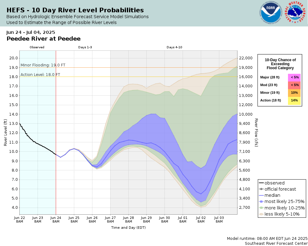 |
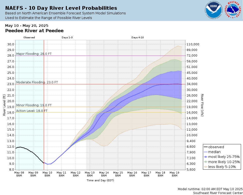 |
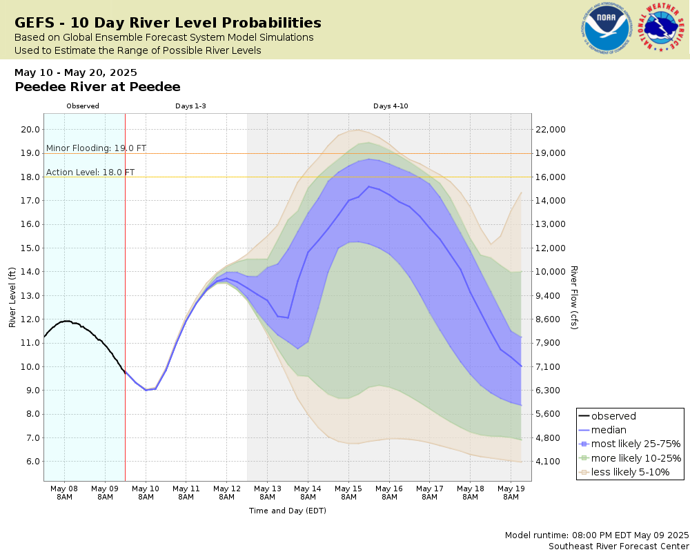 |
Note: The official hydrograph at the top of this web page was made by a river forecaster using past rainfall and forecast rainfall for the next 48 hours. The Potential River Level graphics are computer generated and most useful for rain expected beyond 48 hours.
Click individual graphics to enlarge.
Collaborative Agencies
The National Weather Service prepares its forecasts and other services in collaboration with agencies like the US Geological Survey, US Bureau of Reclamation, US Army Corps of Engineers, Natural Resource Conservation Service, National Park Service, ALERT Users Group, Bureau of Indian Affairs, and many state and local emergency managers across the country. For details, please click here.