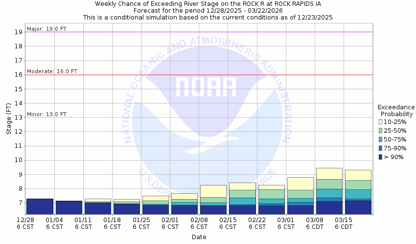
Rock River at Rock Rapids
Future / Actual / Minor
OWP 2.0 WWA Modal Title
01/11/2021, 10:04 PM UTC through 01/11/2021, 10:04 PM UTC
Sender
Sent
- Warning: no valid ratings curve available. Transformations to and from FEET/CFS/KCFS will not happen.
Traces and Thresholds Click to turn on/off display
Observed (OBS) 06/12/2025 10:15 PM CDTRecord: 28.6 ftCATEGORY STAGE 
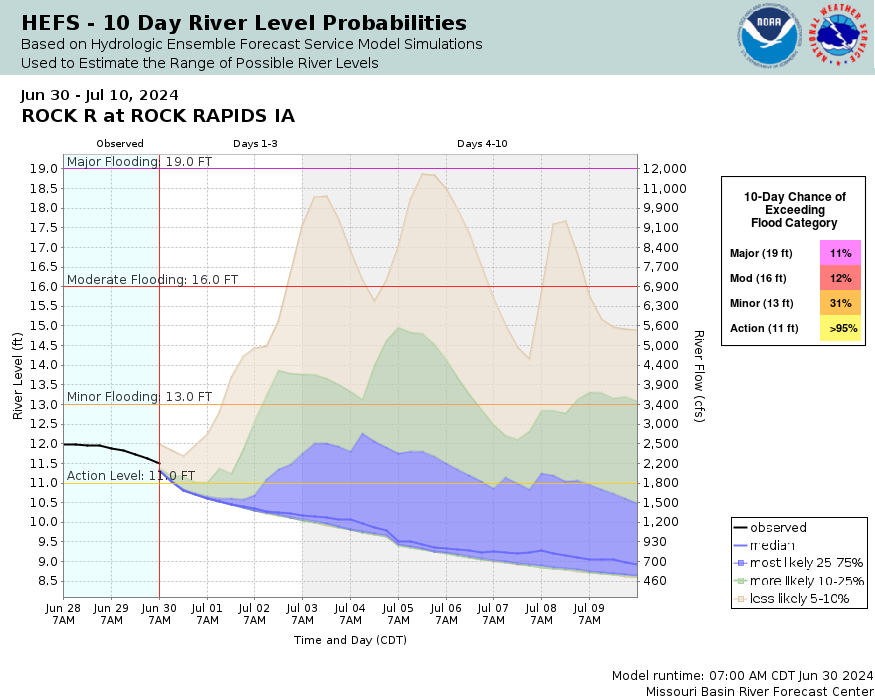
Major Flooding 19 ft Moderate Flooding 16 ft Minor Flooding 13 ft Action 11 ft Reliability of the Forecast:
NOTE: Forecasts are issued as needed during times of high water, but are not routinely available.
River forecasts for this location take into account past and future precipitation. The stages/flows that will occur may be different if future rainfall is different than forecast.
National Water Model Hydrograph
Official NWS streamflow forecasts are produced by NWS hydrologic forecasters for river gauge locations using hydrologic models which are calibrated to that location. This process considers additional guidance and information, including local expertise and experience, to produce the best forecast possible. The NWM output provides supplemental guidance to NWS forecasters and should not be considered an official NWS river forecast.
Flood Impacts
- 28 - Water reaches as far as Greene St on the west side of the river and the bridge on Hwy 9 in Rock Rapids is in danger of being overtopped.
- 27 - Significant flooding will be ongoing in Rock Rapids and water reaches as far Pearl St on the east side of the river and Tama St on the west side. Hwy 75 south of Rock Rapids may also become impassable.
- 26 - Water reaches the bottom of the bridge on Hwy 9.
- 22 - The race track in Rock Rapids begins to flood as does N Boone St if water backs up Moon Creek
- 19 - The highest banks on the right side of the river will be overtopped with water beginning to encroach into the edges of Rock Rapids structures nearest the river.
Gauge Location
Recent Crests
| 1. | 28.65 ft | on 06-22-2024 |
| 2. | 13.40 ft | on 04-13-2023 |
| 3. | 12.11 ft | on 07-06-2022 |
| 4. | 9.26 ft | on 09-04-2021 |
| 5. | 13.80 ft | on 07-07-2020 |
Recent Crests
| 1. | 28.65 ft | on 06-22-2024 |
| 2. | 13.40 ft | on 04-13-2023 |
| 3. | 12.11 ft | on 07-06-2022 |
| 4. | 9.26 ft | on 09-04-2021 |
| 5. | 13.80 ft | on 07-07-2020 |
| 6. | 21.54 ft | on 09-14-2019 |
| 7. | 19.78 ft | on 03-14-2019 |
| 8. | 20.80 ft | on 06-22-2018 |
| 9. | 11.46 ft | on 05-22-2017 |
| 10. | 13.02 ft | on 09-17-2016 |
| 11. | 11.96 ft | on 08-20-2015 |
| 12. | 26.98 ft | on 06-17-2014 |
| 13. | 13.86 ft | on 06-24-2013 |
| 14. | 14.92 ft | on 05-28-2012 |
| 15. | 15.66 ft | on 03-22-2011 |
| 16. | 22.25 ft | on 09-25-2010 |
| 17. | 12.83 ft | on 02-10-2009 |
| 18. | 16.49 ft | on 06-06-2008 |
| 19. | 19.79 ft | on 03-15-2007 |
| 20. | 17.81 ft | on 04-08-2006 |
| 21. | 12.57 ft | on 07-25-2005 |
| 22. | 14.27 ft | on 03-02-2004 |
| 23. | 9.66 ft | on 04-20-2003 |
| 24. | 9.95 ft | on 03-30-2002 |
Historic Crests
| 1. | 28.65 ft | on 06-22-2024 |
| 2. | 26.98 ft | on 06-17-2014 |
| 3. | 22.25 ft | on 09-25-2010 |
| 4. | 21.54 ft | on 09-14-2019 |
| 5. | 20.80 ft | on 06-22-2018 |
Historic Crests
| 1. | 28.65 ft | on 06-22-2024 |
| 2. | 26.98 ft | on 06-17-2014 |
| 3. | 22.25 ft | on 09-25-2010 |
| 4. | 21.54 ft | on 09-14-2019 |
| 5. | 20.80 ft | on 06-22-2018 |
| 6. | 19.79 ft | on 03-15-2007 |
| 7. | 19.78 ft | on 03-14-2019 |
| 8. | 17.81 ft | on 04-08-2006 |
| 9. | 16.49 ft | on 06-06-2008 |
| 10. | 15.66 ft | on 03-22-2011 |
| 11. | 14.92 ft | on 05-28-2012 |
| 12. | 14.27 ft | on 03-02-2004 |
| 13. | 13.86 ft | on 06-24-2013 |
| 14. | 13.80 ft | on 07-07-2020 |
| 15. | 13.40 ft | on 04-13-2023 |
| 16. | 13.02 ft | on 09-17-2016 |
| 17. | 12.83 ft | on 02-10-2009 |
| 18. | 12.57 ft | on 07-25-2005 |
| 19. | 12.11 ft | on 07-06-2022 |
| 20. | 11.96 ft | on 08-20-2015 |
| 21. | 11.46 ft | on 05-22-2017 |
| 22. | 9.95 ft | on 03-30-2002 |
| 23. | 9.66 ft | on 04-20-2003 |
| 24. | 9.26 ft | on 09-04-2021 |
Vertical Datum Table
| type | NAVD88 |
|---|---|
| major Flooding | 1327.93 ft |
| moderate Flooding | 1324.93 ft |
| minor Flooding | 1321.93 ft |
| action | 1319.93 ft |
| Latest Value | 1316.37 ft |
| Gauge Zero | 1308.93 ft |


Collaborative Agencies
The National Weather Service prepares its forecasts and other services in collaboration with agencies like the US Geological Survey, US Bureau of Reclamation, US Army Corps of Engineers, Natural Resource Conservation Service, National Park Service, ALERT Users Group, Bureau of Indian Affairs, and many state and local emergency managers across the country. For details, please click here.
Resources
Hydrologic Resource Links
- River Forecast Centers
- NWS Sioux Falls Flooding Resource Page
- NOHRSC Snow Information
- USACE Missouri River Water Management
- USGS National Water Dashboard
- FEMA Flood Insurance Information
- South Dakota Flood Information System
- Iowa Flood Information System
- Missouri River Flood Information System
- Minnesota DNR
- Nebraska Real-Time Flood Forecasting
- ___