Cowlitz River at Randle
Future / Actual / Minor
OWP 2.0 WWA Modal Title
01/11/2021, 10:04 PM UTC through 01/11/2021, 10:04 PM UTC
Sender
Sent
- Warning: no valid ratings curve available. Transformations to and from FEET/CFS/KCFS will not happen.
Traces and Thresholds Click to turn on/off display
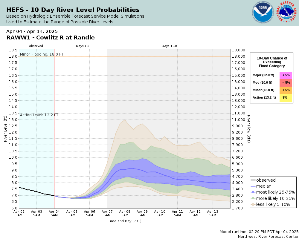
Observed (OBS) 04/01/2025 3:30 AM PDTOfficial Forecast (FCST) 03/31/2025 3:42 PM PDTRecord: 25.2 ftLow Threshold: 0 ftCATEGORY STAGE 
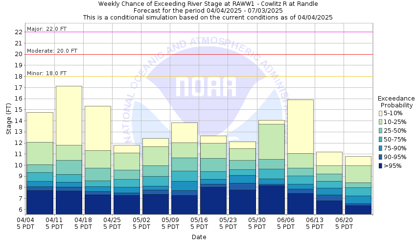
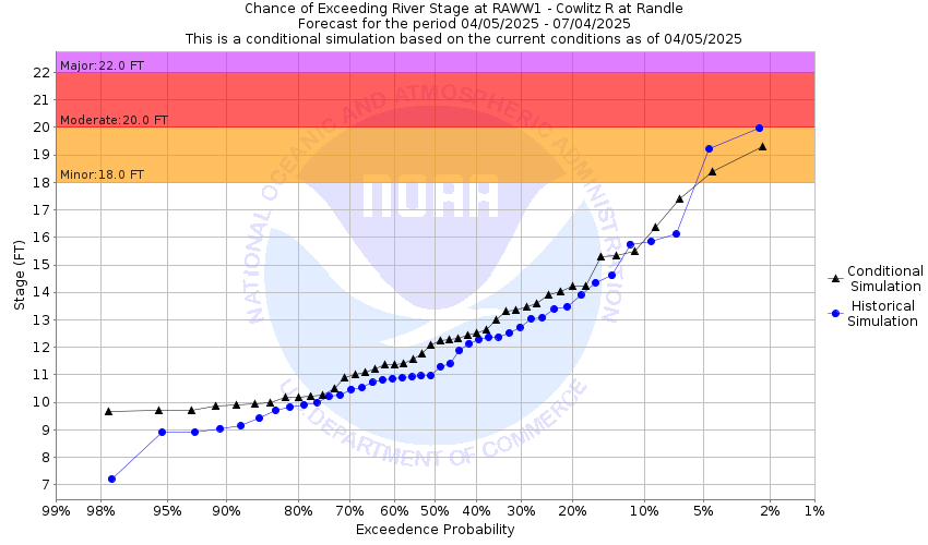
Major Flooding 22 ft Moderate Flooding 20 ft Minor Flooding 18 ft Action 13.2 ft Reliability of the Forecast: Based on current and forecast river, weather and reservoir conditions
NOTE: Forecasts are issued routinely year-round.
River forecasts for this location take into account past and future precipitation. The stages/flows that will occur may be different if future rainfall is different than forecast.
National Water Model Hydrograph
Official NWS streamflow forecasts are produced by NWS hydrologic forecasters for river gauge locations using hydrologic models which are calibrated to that location. This process considers additional guidance and information, including local expertise and experience, to produce the best forecast possible. The NWM output provides supplemental guidance to NWS forecasters and should not be considered an official NWS river forecast.
Flood Impacts
- 22 - the Cowlitz River will cause major flooding from the vicinity of Randle downstream through Riffe Lake...with dangerous inundation of many roads including US Highway 12...residential and commercial areas...and farms. Flooding will occur all along the river including headwaters...tributaries...and other streams within and near the Cowlitz River Basin.
- 20 - the Cowlitz River will cause flooding from the vicinity of Randle downstream through Riffe Lake...inundating many roads including US Highway 12 and much of the farm lands.
- 18 - the Cowlitz River will cause minor flooding from the vicinity of Randle downstream through Riffe Lake...covering nearby farm lands and several roads.
Gauge Info
| Coordinates | 46.5319, -121.957 |
| RFC | NWRFC |
| State | WA |
| WFO | SEW |
| County | Lewis |
| Data Provider(s) | |
| US Geological Survey | USGS--Water Resources of the United States |
| USGS | 14231000 |
Gauge Location
Recent Crests
| 1. | 21.31 ft | on 12-06-2023 | (P) |
| 2. | 19.07 ft | on 11-05-2022 | (P) |
| 3. | 19.52 ft | on 03-01-2022 | (P) |
| 4. | 22.28 ft | on 11-13-2021 | (P) |
| 5. | 19.30 ft | on 01-13-2021 | (P) |
Recent Crests
| 1. | 21.31 ft | on 12-06-2023 | (P) |
| 2. | 19.07 ft | on 11-05-2022 | (P) |
| 3. | 19.52 ft | on 03-01-2022 | (P) |
| 4. | 22.28 ft | on 11-13-2021 | (P) |
| 5. | 19.30 ft | on 01-13-2021 | (P) |
| 6. | 20.94 ft | on 02-08-2020 | (P) |
| 7. | 20.89 ft | on 11-23-2017 | (P) |
| 8. | 18.15 ft | on 11-22-2017 | (P) |
| 9. | 20.30 ft | on 10-22-2017 | (P) |
| 10. | 18.53 ft | on 03-16-2017 | (P) |
| 11. | 24.11 ft | on 12-09-2015 | (P) |
| 12. | 21.88 ft | on 11-18-2015 | (P) |
| 13. | 18.72 ft | on 11-01-2015 | (P) |
| 14. | 19.23 ft | on 11-26-2014 | (P) |
| 15. | 18.72 ft | on 03-09-2014 | |
| 16. | 17.46 ft | on 12-02-2013 | (P) |
| 17. | 15.21 ft | on 10-31-2012 | |
| 18. | 17.52 ft | on 02-22-2012 | |
| 19. | 22.43 ft | on 01-17-2011 | |
| 20. | 13.02 ft | on 06-03-2010 | |
| 21. | 22.85 ft | on 01-07-2009 | (P) |
| 22. | 22.13 ft | on 11-12-2008 | (P) |
| 23. | 17.91 ft | on 05-18-2008 | |
| 24. | 25.24 ft | on 11-07-2006 | |
| 25. | 20.11 ft | on 01-18-2005 | |
| 26. | 22.49 ft | on 01-31-2003 | |
| 27. | 16.37 ft | on 01-26-2003 | (P) |
| 28. | 19.77 ft | on 01-08-2002 | |
| 29. | 21.13 ft | on 11-26-1999 | |
| 30. | 20.67 ft | on 12-30-1998 | |
| 31. | 19.83 ft | on 10-31-1997 | |
| 32. | 19.27 ft | on 03-20-1997 | |
| 33. | 18.53 ft | on 01-01-1997 | |
| 34. | 13.19 ft | on 04-24-1996 | |
| 35. | 24.90 ft | on 02-09-1996 | |
| 36. | 14.98 ft | on 01-08-1996 | |
| 37. | 14.15 ft | on 12-13-1995 | |
| 38. | 23.58 ft | on 11-30-1995 | |
| 39. | 13.13 ft | on 11-25-1995 | |
| 40. | 15.83 ft | on 11-14-1995 | |
| 41. | 19.03 ft | on 11-11-1995 | |
| 42. | 19.38 ft | on 11-09-1995 | |
| 43. | 18.93 ft | on 02-20-1995 |
Historic Crests
| 1. | 25.24 ft | on 11-07-2006 | |
| 2. | 24.90 ft | on 02-09-1996 | |
| 3. | 24.11 ft | on 12-09-2015 | (P) |
| 4. | 23.58 ft | on 11-30-1995 | |
| 5. | 22.85 ft | on 01-07-2009 | (P) |
Historic Crests
| 1. | 25.24 ft | on 11-07-2006 | |
| 2. | 24.90 ft | on 02-09-1996 | |
| 3. | 24.11 ft | on 12-09-2015 | (P) |
| 4. | 23.58 ft | on 11-30-1995 | |
| 5. | 22.85 ft | on 01-07-2009 | (P) |
| 6. | 22.49 ft | on 01-31-2003 | |
| 7. | 22.43 ft | on 01-17-2011 | |
| 8. | 22.28 ft | on 11-13-2021 | (P) |
| 9. | 22.13 ft | on 11-12-2008 | (P) |
| 10. | 21.88 ft | on 11-18-2015 | (P) |
| 11. | 21.31 ft | on 12-06-2023 | (P) |
| 12. | 21.13 ft | on 11-26-1999 | |
| 13. | 20.94 ft | on 02-08-2020 | (P) |
| 14. | 20.89 ft | on 11-23-2017 | (P) |
| 15. | 20.67 ft | on 12-30-1998 | |
| 16. | 20.30 ft | on 10-22-2017 | (P) |
| 17. | 20.11 ft | on 01-18-2005 | |
| 18. | 19.83 ft | on 10-31-1997 | |
| 19. | 19.77 ft | on 01-08-2002 | |
| 20. | 19.52 ft | on 03-01-2022 | (P) |
| 21. | 19.38 ft | on 11-09-1995 | |
| 22. | 19.30 ft | on 01-13-2021 | (P) |
| 23. | 19.27 ft | on 03-20-1997 | |
| 24. | 19.23 ft | on 11-26-2014 | (P) |
| 25. | 19.07 ft | on 11-05-2022 | (P) |
| 26. | 19.03 ft | on 11-11-1995 | |
| 27. | 18.93 ft | on 02-20-1995 | |
| 28. | 18.72 ft | on 03-09-2014 | |
| 29. | 18.72 ft | on 11-01-2015 | (P) |
| 30. | 18.53 ft | on 03-16-2017 | (P) |
| 31. | 18.53 ft | on 01-01-1997 | |
| 32. | 18.15 ft | on 11-22-2017 | (P) |
| 33. | 17.91 ft | on 05-18-2008 | |
| 34. | 17.52 ft | on 02-22-2012 | |
| 35. | 17.46 ft | on 12-02-2013 | (P) |
| 36. | 16.37 ft | on 01-26-2003 | (P) |
| 37. | 15.83 ft | on 11-14-1995 | |
| 38. | 15.21 ft | on 10-31-2012 | |
| 39. | 14.98 ft | on 01-08-1996 | |
| 40. | 14.15 ft | on 12-13-1995 | |
| 41. | 13.19 ft | on 04-24-1996 | |
| 42. | 13.13 ft | on 11-25-1995 | |
| 43. | 13.02 ft | on 06-03-2010 |
Vertical Datum Table
| type | NGVD29 |
|---|---|
| major Flooding | 902.00 ft |
| moderate Flooding | 900.00 ft |
| minor Flooding | 898.00 ft |
| action | 893.20 ft |
| Latest Value | 888.15 ft |
| Gauge Zero | 880.00 ft |
Gauge Photos
No Images Found

Collaborative Agencies
The National Weather Service prepares its forecasts and other services in collaboration with agencies like the US Geological Survey, US Bureau of Reclamation, US Army Corps of Engineers, Natural Resource Conservation Service, National Park Service, ALERT Users Group, Bureau of Indian Affairs, and many state and local emergency managers across the country. For details, please click here.