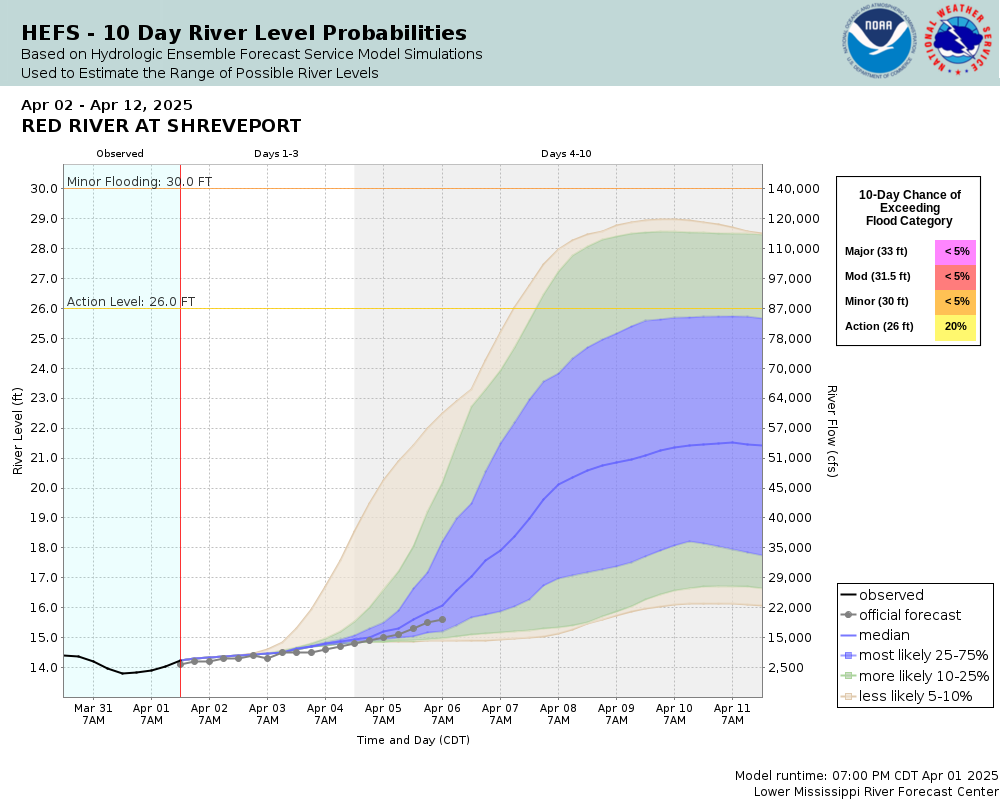
Red River at Shreveport
Future / Actual / Minor
OWP 2.0 WWA Modal Title
01/11/2021, 10:04 PM UTC through 01/11/2021, 10:04 PM UTC
Sender
Sent
- Warning: no valid ratings curve available. Transformations to and from FEET/CFS/KCFS will not happen.
Traces and Thresholds Click to turn on/off display
Observed (OBS) 03/29/2025 7:00 PM CDTOfficial Forecast (FCST) 03/29/2025 10:33 AM CDTRecord: 45.9 ftCATEGORY STAGE 
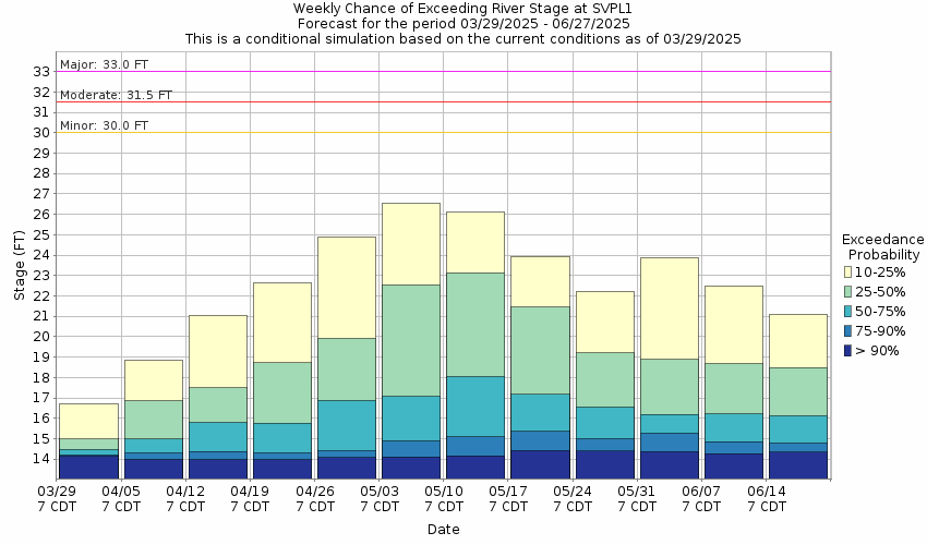
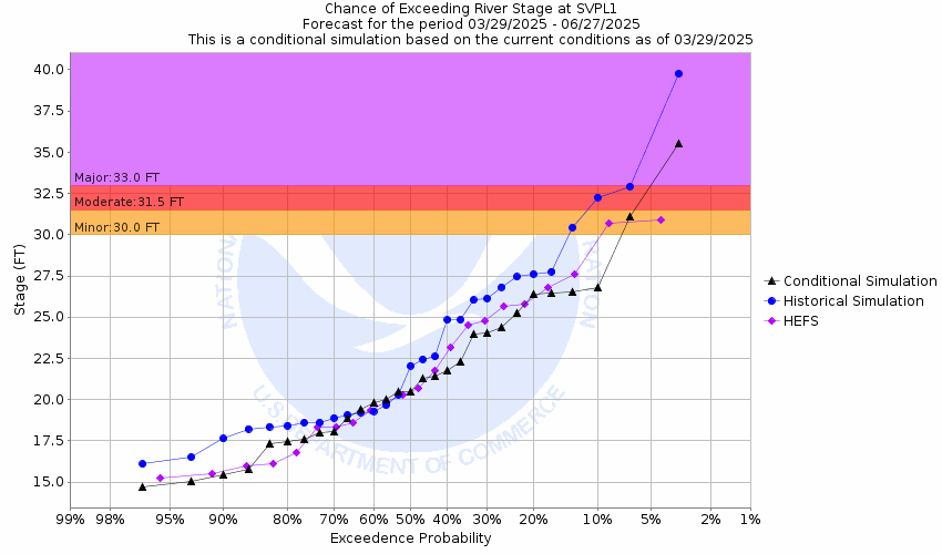
Major Flooding 33 ft Moderate Flooding 31.5 ft Minor Flooding 30 ft Action 26 ft Reliability of the Forecast: Based on current and forecast river, weather and reservoir conditions
NOTE: Forecasts are issued routinely year-round.
River forecasts for this location take into account past precipitation and the precipitation amounts expected approximately 24 hours into the future from the forecast issuance time.
National Water Model Hydrograph
Official NWS streamflow forecasts are produced by NWS hydrologic forecasters for river gauge locations using hydrologic models which are calibrated to that location. This process considers additional guidance and information, including local expertise and experience, to produce the best forecast possible. The NWM output provides supplemental guidance to NWS forecasters and should not be considered an official NWS river forecast.
Flood Impacts
- 50 - Disastrous flooding of Bossier City and Shreveport area. Water will overtop the levee on the Bossier City side. Also expect disastrous backwater flooding of Cross and Caddo lakes with their pool stages rising to near 180.0 ft msl. Disastrous backwater flooding will affect Caddo Lake and the Big Cypress Bayou to near Karnack, Texas.
- 39.5 - Severe flooding will take place in parts of downtown Shreveport in the riverfront area. Area casinos are in danger of being flooded. Severe backwater flooding will worsen on Cross and Caddo lakes and will result in their pool stages rising to near 171.0 feet. Also parts of the levee between downtown Shreveport and the Jimmie Davis bridge will be topped without sandbagging efforts.
- 37.5 - Flooding closes entrance and exit ramps to the Shreveport-Blanchard highway with Interstate 220 interchange. Severe backwater flooding of Cross and Twelve Mile Bayous with backwater flooding to just below Caddo Lake.
Gauge Info
| Coordinates | 32.5153, -93.7403 |
| RFC | LMRFC |
| State | LA |
| WFO | SHV |
| County | Caddo |
| Data Provider(s) | |
| US Army Corps of Engineers | US Army Corps of Engineers |
| USGS | 07348500 |
Gauge Location
Recent Crests
| 1. | 31.26 ft | on 05-11-2019 |
| 2. | 31.39 ft | on 03-04-2018 |
| 3. | 32.39 ft | on 05-04-2016 |
| 4. | 31.79 ft | on 03-15-2016 |
| 5. | 31.05 ft | on 06-30-2015 |
Recent Crests
| 1. | 31.26 ft | on 05-11-2019 | |
| 2. | 31.39 ft | on 03-04-2018 | |
| 3. | 32.39 ft | on 05-04-2016 | |
| 4. | 31.79 ft | on 03-15-2016 | |
| 5. | 31.05 ft | on 06-30-2015 | |
| 6. | 37.14 ft | on 06-09-2015 | |
| 7. | 29.45 ft | on 11-01-2009 | |
| 8. | 29.40 ft | on 03-15-2001 | |
| 9. | 29.80 ft | on 03-05-2001 | |
| 10. | 29.30 ft | on 02-20-2001 | |
| 11. | 27.50 ft | on 11-29-1996 | |
| 12. | 27.40 ft | on 02-25-1996 | |
| 13. | 26.50 ft | on 05-12-1995 | |
| 14. | 34.50 ft | on 05-15-1990 | |
| 15. | 26.50 ft | on 04-29-1973 | |
| 16. | 29.60 ft | on 05-05-1966 | |
| 17. | 33.70 ft | on 05-08-1958 | |
| 18. | 32.82 ft | on 06-11-1957 | |
| 19. | 27.40 ft | on 05-20-1953 | |
| 20. | 26.70 ft | on 02-18-1950 | |
| 21. | 26.40 ft | on 02-02-1949 | |
| 22. | 38.30 ft | on 04-07-1945 | |
| 23. | 27.80 ft | on 05-09-1944 | |
| 24. | 31.40 ft | on 05-05-1942 | |
| 25. | 28.00 ft | on 05-11-1941 | |
| 26. | 33.50 ft | on 03-01-1938 | 1 |
| 27. | 32.60 ft | on 05-29-1935 | 1 |
| 28. | 31.70 ft | on 01-31-1932 | 1 |
| 29. | 35.90 ft | on 05-26-1930 | 1 |
| 30. | 27.50 ft | on 05-27-1929 | 1 |
| 31. | 37.40 ft | on 04-30-1927 | |
| 32. | 26.30 ft | on 12-27-1926 | |
| 33. | 30.40 ft | on 12-26-1923 | |
| 34. | 31.30 ft | on 05-05-1922 | |
| 35. | 28.40 ft | on 05-03-1921 | |
| 36. | 36.10 ft | on 05-27-1920 | |
| 37. | 31.50 ft | on 10-31-1919 | |
| 38. | 26.90 ft | on 04-25-1918 | |
| 39. | 35.50 ft | on 02-10-1916 | |
| 40. | 39.00 ft | on 05-09-1915 | |
| 41. | 32.93 ft | on 04-10-1914 | |
| 42. | 29.30 ft | on 04-14-1912 | |
| 43. | 45.10 ft | on 06-15-1908 | |
| 44. | 36.90 ft | on 06-13-1907 | |
| 45. | 32.60 ft | on 01-02-1906 | |
| 46. | 43.60 ft | on 06-09-1905 | |
| 47. | 38.50 ft | on 06-24-1904 | |
| 48. | 43.10 ft | on 03-22-1903 | |
| 49. | 44.10 ft | on 12-15-1902 | |
| 50. | 26.40 ft | on 06-07-1901 | |
| 51. | 34.10 ft | on 04-11-1897 | |
| 52. | 40.30 ft | on 07-29-1895 | |
| 53. | 44.40 ft | on 04-02-1894 | |
| 54. | 39.10 ft | on 01-01-1893 | |
| 55. | 45.70 ft | on 05-28-1892 | |
| 56. | 35.20 ft | on 02-12-1891 | |
| 57. | 44.70 ft | on 02-08-1890 | |
| 58. | 41.90 ft | on 02-03-1889 | |
| 59. | 40.30 ft | on 05-19-1888 | |
| 60. | 26.80 ft | on 12-30-1887 | |
| 61. | 40.20 ft | on 05-11-1885 | |
| 62. | 42.70 ft | on 05-14-1884 | |
| 63. | 35.30 ft | on 03-11-1883 | |
| 64. | 41.40 ft | on 02-21-1882 | |
| 65. | 37.30 ft | on 03-07-1881 | |
| 66. | 33.20 ft | on 04-04-1880 | |
| 67. | 34.90 ft | on 05-16-1879 | |
| 68. | 38.40 ft | on 01-31-1878 | |
| 69. | 39.80 ft | on 05-11-1877 | |
| 70. | 41.90 ft | on 07-28-1876 | |
| 71. | 35.80 ft | on 04-22-1875 | |
| 72. | 37.90 ft | on 04-28-1874 | |
| 73. | 35.50 ft | on 06-08-1873 | |
| 74. | 45.90 ft | on 08-10-1849 |
Historic Crests
| 1. | 45.90 ft | on 08-10-1849 |
| 2. | 45.70 ft | on 05-28-1892 |
| 3. | 45.10 ft | on 06-15-1908 |
| 4. | 44.70 ft | on 02-08-1890 |
| 5. | 44.40 ft | on 04-02-1894 |
Historic Crests
| 1. | 45.90 ft | on 08-10-1849 | |
| 2. | 45.70 ft | on 05-28-1892 | |
| 3. | 45.10 ft | on 06-15-1908 | |
| 4. | 44.70 ft | on 02-08-1890 | |
| 5. | 44.40 ft | on 04-02-1894 | |
| 6. | 44.10 ft | on 12-15-1902 | |
| 7. | 43.60 ft | on 06-09-1905 | |
| 8. | 43.10 ft | on 03-22-1903 | |
| 9. | 42.70 ft | on 05-14-1884 | |
| 10. | 41.90 ft | on 02-03-1889 | |
| 11. | 41.90 ft | on 07-28-1876 | |
| 12. | 41.40 ft | on 02-21-1882 | |
| 13. | 40.30 ft | on 07-29-1895 | |
| 14. | 40.30 ft | on 05-19-1888 | |
| 15. | 40.20 ft | on 05-11-1885 | |
| 16. | 39.80 ft | on 05-11-1877 | |
| 17. | 39.10 ft | on 01-01-1893 | |
| 18. | 39.00 ft | on 05-09-1915 | |
| 19. | 38.50 ft | on 06-24-1904 | |
| 20. | 38.40 ft | on 01-31-1878 | |
| 21. | 38.30 ft | on 04-07-1945 | |
| 22. | 37.90 ft | on 04-28-1874 | |
| 23. | 37.40 ft | on 04-30-1927 | |
| 24. | 37.30 ft | on 03-07-1881 | |
| 25. | 37.14 ft | on 06-09-2015 | |
| 26. | 36.90 ft | on 06-13-1907 | |
| 27. | 36.10 ft | on 05-27-1920 | |
| 28. | 35.90 ft | on 05-26-1930 | 1 |
| 29. | 35.80 ft | on 04-22-1875 | |
| 30. | 35.50 ft | on 06-08-1873 | |
| 31. | 35.50 ft | on 02-10-1916 | |
| 32. | 35.30 ft | on 03-11-1883 | |
| 33. | 35.20 ft | on 02-12-1891 | |
| 34. | 34.90 ft | on 05-16-1879 | |
| 35. | 34.50 ft | on 05-15-1990 | |
| 36. | 34.10 ft | on 04-11-1897 | |
| 37. | 33.70 ft | on 05-08-1958 | |
| 38. | 33.50 ft | on 03-01-1938 | 1 |
| 39. | 33.20 ft | on 04-04-1880 | |
| 40. | 32.93 ft | on 04-10-1914 | |
| 41. | 32.82 ft | on 06-11-1957 | |
| 42. | 32.60 ft | on 01-02-1906 | |
| 43. | 32.60 ft | on 05-29-1935 | 1 |
| 44. | 32.39 ft | on 05-04-2016 | |
| 45. | 31.79 ft | on 03-15-2016 | |
| 46. | 31.70 ft | on 01-31-1932 | 1 |
| 47. | 31.50 ft | on 10-31-1919 | |
| 48. | 31.40 ft | on 05-05-1942 | |
| 49. | 31.39 ft | on 03-04-2018 | |
| 50. | 31.30 ft | on 05-05-1922 | |
| 51. | 31.26 ft | on 05-11-2019 | |
| 52. | 31.05 ft | on 06-30-2015 | |
| 53. | 30.40 ft | on 12-26-1923 | |
| 54. | 29.80 ft | on 03-05-2001 | |
| 55. | 29.60 ft | on 05-05-1966 | |
| 56. | 29.45 ft | on 11-01-2009 | |
| 57. | 29.40 ft | on 03-15-2001 | |
| 58. | 29.30 ft | on 04-14-1912 | |
| 59. | 29.30 ft | on 02-20-2001 | |
| 60. | 28.40 ft | on 05-03-1921 | |
| 61. | 28.00 ft | on 05-11-1941 | |
| 62. | 27.80 ft | on 05-09-1944 | |
| 63. | 27.50 ft | on 05-27-1929 | 1 |
| 64. | 27.50 ft | on 11-29-1996 | |
| 65. | 27.40 ft | on 02-25-1996 | |
| 66. | 27.40 ft | on 05-20-1953 | |
| 67. | 26.90 ft | on 04-25-1918 | |
| 68. | 26.80 ft | on 12-30-1887 | |
| 69. | 26.70 ft | on 02-18-1950 | |
| 70. | 26.50 ft | on 04-29-1973 | |
| 71. | 26.50 ft | on 05-12-1995 | |
| 72. | 26.40 ft | on 06-07-1901 | |
| 73. | 26.40 ft | on 02-02-1949 | |
| 74. | 26.30 ft | on 12-27-1926 |
Gauge Photos
No Images Found

Unique Local Info
During periods of possible very heavy rainfall, river forecasts may take into account precipitation amounts expected 30, 36, or even 48 hours into the future from the forecast issuance time.
Collaborative Agencies
The National Weather Service prepares its forecasts and other services in collaboration with agencies like the US Geological Survey, US Bureau of Reclamation, US Army Corps of Engineers, Natural Resource Conservation Service, National Park Service, ALERT Users Group, Bureau of Indian Affairs, and many state and local emergency managers across the country. For details, please click here.