Santee River near Jamestown
Future / Actual / Minor
OWP 2.0 WWA Modal Title
01/11/2021, 10:04 PM UTC through 01/11/2021, 10:04 PM UTC
Sender
Sent
- Warning: no valid ratings curve available. Transformations to and from FEET/CFS/KCFS will not happen.No secondary data available. Transformations for Flow data and a secondary Y axis cannot be made at this time.
Traces and Thresholds Click to turn on/off display
CATEGORY STAGE Major Flooding 22 ft Moderate Flooding 17 ft Minor Flooding 10 ft Action 9 ft Reliability of the Forecast:
NOTE: Forecasts are issued as needed during times of high water, but are not routinely available.
River forecasts for this location take into account past precipitation and the precipitation amounts expected approximately 48 hours into the future from the forecast issuance time.
National Water Model Hydrograph
Official NWS streamflow forecasts are produced by NWS hydrologic forecasters for river gauge locations using hydrologic models which are calibrated to that location. This process considers additional guidance and information, including local expertise and experience, to produce the best forecast possible. The NWM output provides supplemental guidance to NWS forecasters and should not be considered an official NWS river forecast.
Flood Impacts
- 24 - water will start to enter the lower level of the home at the end of Lawton Farm Lane.
- 22 - water will surround the residence at the end of Crow Hill Drive and portions of the road will be covered with water due to backwater effects. The lower three quarters of a mile of Corner Loop Road is flooded and a few homes will be impacted. Water will restrict access to Belleflower Way and Belladonna Court and approach a few homes in the Belleflower Plantation subdivision. The residence at the end of Lawton Farm Lane is also surrounded by water and the lower portion of Old Gate Lane is covered by water.
- 19 - the lower quarter mile of Lawton Farm Lane is impassable.
Gauge Location
Recent Crests
| 1. | 10.63 ft | on 06-21-2025 |
| 2. | 12.63 ft | on 05-20-2025 |
| 3. | 12.48 ft | on 02-23-2025 |
| 4. | 11.72 ft | on 01-24-2025 |
| 5. | 10.59 ft | on 12-16-2024 |
Recent Crests
| 1. | 10.63 ft | on 06-21-2025 |
| 2. | 12.63 ft | on 05-20-2025 |
| 3. | 12.48 ft | on 02-23-2025 |
| 4. | 11.72 ft | on 01-24-2025 |
| 5. | 10.59 ft | on 12-16-2024 |
| 6. | 23.94 ft | on 10-05-2024 |
| 7. | 15.59 ft | on 08-10-2024 |
| 8. | 12.86 ft | on 05-21-2024 |
| 9. | 10.61 ft | on 04-10-2024 |
| 10. | 10.05 ft | on 04-02-2024 |
| 11. | 16.55 ft | on 03-16-2024 |
| 12. | 19.61 ft | on 01-18-2024 |
| 13. | 12.63 ft | on 06-29-2023 |
| 14. | 14.35 ft | on 05-06-2023 |
| 15. | 12.80 ft | on 04-18-2023 |
| 16. | 12.58 ft | on 02-20-2023 |
| 17. | 13.63 ft | on 02-03-2023 |
| 18. | 13.25 ft | on 12-28-2022 |
| 19. | 11.10 ft | on 04-24-2022 |
| 20. | 14.64 ft | on 04-14-2022 |
| 21. | 12.91 ft | on 03-25-2022 |
| 22. | 12.37 ft | on 01-09-2022 |
| 23. | 14.17 ft | on 04-06-2021 |
| 24. | 17.19 ft | on 02-27-2021 |
| 25. | 15.15 ft | on 11-21-2020 |
| 26. | 10.26 ft | on 11-05-2020 |
| 27. | 11.43 ft | on 10-18-2020 |
| 28. | 12.96 ft | on 09-25-2020 |
| 29. | 11.90 ft | on 08-29-2020 |
| 30. | 17.23 ft | on 05-30-2020 |
| 31. | 13.01 ft | on 05-10-2020 |
| 32. | 10.00 ft | on 04-27-2020 |
| 33. | 11.42 ft | on 04-25-2020 |
| 34. | 13.12 ft | on 04-03-2020 |
| 35. | 23.37 ft | on 02-14-2020 |
| 36. | 12.80 ft | on 06-17-2019 |
| 37. | 13.02 ft | on 04-19-2019 |
| 38. | 19.19 ft | on 12-30-2018 |
| 39. | 11.45 ft | on 11-06-2018 |
| 40. | 11.81 ft | on 10-14-2018 |
| 41. | 10.63 ft | on 09-18-2018 |
| 42. | 10.00 ft | on 08-07-2018 |
| 43. | 12.88 ft | on 06-10-2018 |
| 44. | 12.81 ft | on 05-03-2018 |
| 45. | 11.60 ft | on 02-15-2018 |
| 46. | 12.24 ft | on 05-30-2017 |
| 47. | 13.09 ft | on 05-02-2017 |
| 48. | 13.06 ft | on 10-10-2016 |
| 49. | 10.23 ft | on 05-30-2016 |
| 50. | 11.16 ft | on 03-23-2016 |
| 51. | 22.82 ft | on 01-06-2016 |
| 52. | 18.98 ft | on 11-17-2015 |
| 53. | 22.13 ft | on 10-10-2015 |
| 54. | 13.22 ft | on 05-01-2015 |
| 55. | 11.52 ft | on 03-08-2015 |
| 56. | 12.30 ft | on 01-11-2015 |
| 57. | 13.08 ft | on 05-01-2014 |
| 58. | 13.11 ft | on 03-18-2014 |
| 59. | 13.30 ft | on 01-02-2014 |
| 60. | 17.81 ft | on 07-20-2013 |
| 61. | 12.83 ft | on 06-19-2013 |
| 62. | 15.92 ft | on 05-15-2013 |
| 63. | 11.08 ft | on 03-29-2013 |
| 64. | 11.76 ft | on 02-19-2013 |
| 65. | 19.83 ft | on 02-13-2010 |
| 66. | 13.13 ft | on 04-03-2009 |
| 67. | 15.41 ft | on 03-14-2007 |
| 68. | 12.82 ft | on 01-12-2006 |
| 69. | 14.35 ft | on 04-07-2005 |
| 70. | 13.52 ft | on 10-04-2004 |
| 71. | 17.40 ft | on 09-18-2004 |
| 72. | 22.84 ft | on 03-28-2003 |
| 73. | 11.71 ft | on 03-29-2000 |
| 74. | 11.02 ft | on 02-01-2000 |
| 75. | 12.95 ft | on 02-07-1999 |
| 76. | 21.67 ft | on 02-10-1998 |
| 77. | 14.55 ft | on 03-11-1997 |
| 78. | 15.06 ft | on 02-12-1996 |
| 79. | 20.61 ft | on 03-01-1995 |
| 80. | 16.12 ft | on 08-28-1994 |
| 81. | 20.81 ft | on 01-18-1993 |
| 82. | 16.04 ft | on 12-07-1992 |
| 83. | 13.62 ft | on 06-19-1992 |
| 84. | 15.90 ft | on 03-17-1991 |
| 85. | 20.62 ft | on 11-03-1990 |
| 86. | 16.29 ft | on 10-19-1990 |
| 87. | 19.41 ft | on 10-09-1989 |
| 88. | 13.47 ft | on 03-14-1989 |
| 89. | 11.06 ft | on 01-30-1988 |
| 90. | 21.87 ft | on 03-09-1987 |
| 91. | 14.40 ft | on 12-14-1986 |
| 92. | 15.75 ft | on 12-14-1985 |
| 93. | 15.00 ft | on 05-18-1984 |
| 94. | 15.00 ft | on 03-09-1984 |
| 95. | 15.40 ft | on 03-27-1983 |
| 96. | 17.13 ft | on 01-14-1982 |
| 97. | 19.20 ft | on 04-05-1980 |
| 98. | 19.67 ft | on 03-06-1979 |
| 99. | 15.08 ft | on 02-05-1978 |
| 100. | 14.70 ft | on 04-08-1977 |
| 101. | 15.00 ft | on 10-20-1976 |
| 102. | 21.28 ft | on 03-23-1975 |
| 103. | 18.40 ft | on 04-10-1973 |
| 104. | 16.80 ft | on 03-11-1971 |
| 105. | 14.00 ft | on 03-31-1970 |
| 106. | 16.00 ft | on 04-27-1969 |
| 107. | 20.50 ft | on 10-24-1964 |
| 108. | 16.50 ft | on 01-14-1946 |
| 109. | 22.80 ft | on 09-26-1945 |
| 110. | 20.60 ft | on 03-29-1944 |
| 111. | 32.00 ft | on 04-15-1936 |
| 112. | 10.50 ft | on 03-18-1934 |
| 113. | 29.80 ft | on 10-10-1929 |
| 114. | 30.00 ft | on 08-26-1928 |
| 115. | 33.00 ft | on 07-26-1916 |
Historic Crests
| 1. | 33.00 ft | on 07-26-1916 |
| 2. | 32.00 ft | on 04-15-1936 |
| 3. | 30.00 ft | on 08-26-1928 |
| 4. | 29.80 ft | on 10-10-1929 |
| 5. | 23.94 ft | on 10-05-2024 |
Historic Crests
| 1. | 33.00 ft | on 07-26-1916 |
| 2. | 32.00 ft | on 04-15-1936 |
| 3. | 30.00 ft | on 08-26-1928 |
| 4. | 29.80 ft | on 10-10-1929 |
| 5. | 23.94 ft | on 10-05-2024 |
| 6. | 23.37 ft | on 02-14-2020 |
| 7. | 22.84 ft | on 03-28-2003 |
| 8. | 22.82 ft | on 01-06-2016 |
| 9. | 22.80 ft | on 09-26-1945 |
| 10. | 22.13 ft | on 10-10-2015 |
| 11. | 21.87 ft | on 03-09-1987 |
| 12. | 21.67 ft | on 02-10-1998 |
| 13. | 21.28 ft | on 03-23-1975 |
| 14. | 20.81 ft | on 01-18-1993 |
| 15. | 20.62 ft | on 11-03-1990 |
| 16. | 20.61 ft | on 03-01-1995 |
| 17. | 20.60 ft | on 03-29-1944 |
| 18. | 20.50 ft | on 10-24-1964 |
| 19. | 19.83 ft | on 02-13-2010 |
| 20. | 19.67 ft | on 03-06-1979 |
| 21. | 19.61 ft | on 01-18-2024 |
| 22. | 19.41 ft | on 10-09-1989 |
| 23. | 19.20 ft | on 04-05-1980 |
| 24. | 19.19 ft | on 12-30-2018 |
| 25. | 18.98 ft | on 11-17-2015 |
| 26. | 18.40 ft | on 04-10-1973 |
| 27. | 17.81 ft | on 07-20-2013 |
| 28. | 17.40 ft | on 09-18-2004 |
| 29. | 17.23 ft | on 05-30-2020 |
| 30. | 17.19 ft | on 02-27-2021 |
| 31. | 17.13 ft | on 01-14-1982 |
| 32. | 16.80 ft | on 03-11-1971 |
| 33. | 16.55 ft | on 03-16-2024 |
| 34. | 16.50 ft | on 01-14-1946 |
| 35. | 16.29 ft | on 10-19-1990 |
| 36. | 16.12 ft | on 08-28-1994 |
| 37. | 16.04 ft | on 12-07-1992 |
| 38. | 16.00 ft | on 04-27-1969 |
| 39. | 15.92 ft | on 05-15-2013 |
| 40. | 15.90 ft | on 03-17-1991 |
| 41. | 15.75 ft | on 12-14-1985 |
| 42. | 15.59 ft | on 08-10-2024 |
| 43. | 15.41 ft | on 03-14-2007 |
| 44. | 15.40 ft | on 03-27-1983 |
| 45. | 15.15 ft | on 11-21-2020 |
| 46. | 15.08 ft | on 02-05-1978 |
| 47. | 15.06 ft | on 02-12-1996 |
| 48. | 15.00 ft | on 03-09-1984 |
| 49. | 15.00 ft | on 10-20-1976 |
| 50. | 15.00 ft | on 05-18-1984 |
| 51. | 14.70 ft | on 04-08-1977 |
| 52. | 14.64 ft | on 04-14-2022 |
| 53. | 14.55 ft | on 03-11-1997 |
| 54. | 14.40 ft | on 12-14-1986 |
| 55. | 14.35 ft | on 04-07-2005 |
| 56. | 14.35 ft | on 05-06-2023 |
| 57. | 14.17 ft | on 04-06-2021 |
| 58. | 14.00 ft | on 03-31-1970 |
| 59. | 13.63 ft | on 02-03-2023 |
| 60. | 13.62 ft | on 06-19-1992 |
| 61. | 13.52 ft | on 10-04-2004 |
| 62. | 13.47 ft | on 03-14-1989 |
| 63. | 13.30 ft | on 01-02-2014 |
| 64. | 13.25 ft | on 12-28-2022 |
| 65. | 13.22 ft | on 05-01-2015 |
| 66. | 13.13 ft | on 04-03-2009 |
| 67. | 13.12 ft | on 04-03-2020 |
| 68. | 13.11 ft | on 03-18-2014 |
| 69. | 13.09 ft | on 05-02-2017 |
| 70. | 13.08 ft | on 05-01-2014 |
| 71. | 13.06 ft | on 10-10-2016 |
| 72. | 13.02 ft | on 04-19-2019 |
| 73. | 13.01 ft | on 05-10-2020 |
| 74. | 12.96 ft | on 09-25-2020 |
| 75. | 12.95 ft | on 02-07-1999 |
| 76. | 12.91 ft | on 03-25-2022 |
| 77. | 12.88 ft | on 06-10-2018 |
| 78. | 12.86 ft | on 05-21-2024 |
| 79. | 12.83 ft | on 06-19-2013 |
| 80. | 12.82 ft | on 01-12-2006 |
| 81. | 12.81 ft | on 05-03-2018 |
| 82. | 12.80 ft | on 06-17-2019 |
| 83. | 12.80 ft | on 04-18-2023 |
| 84. | 12.63 ft | on 06-29-2023 |
| 85. | 12.63 ft | on 05-20-2025 |
| 86. | 12.58 ft | on 02-20-2023 |
| 87. | 12.48 ft | on 02-23-2025 |
| 88. | 12.37 ft | on 01-09-2022 |
| 89. | 12.30 ft | on 01-11-2015 |
| 90. | 12.24 ft | on 05-30-2017 |
| 91. | 11.90 ft | on 08-29-2020 |
| 92. | 11.81 ft | on 10-14-2018 |
| 93. | 11.76 ft | on 02-19-2013 |
| 94. | 11.72 ft | on 01-24-2025 |
| 95. | 11.71 ft | on 03-29-2000 |
| 96. | 11.60 ft | on 02-15-2018 |
| 97. | 11.52 ft | on 03-08-2015 |
| 98. | 11.45 ft | on 11-06-2018 |
| 99. | 11.43 ft | on 10-18-2020 |
| 100. | 11.42 ft | on 04-25-2020 |
| 101. | 11.16 ft | on 03-23-2016 |
| 102. | 11.10 ft | on 04-24-2022 |
| 103. | 11.08 ft | on 03-29-2013 |
| 104. | 11.06 ft | on 01-30-1988 |
| 105. | 11.02 ft | on 02-01-2000 |
| 106. | 10.63 ft | on 06-21-2025 |
| 107. | 10.63 ft | on 09-18-2018 |
| 108. | 10.61 ft | on 04-10-2024 |
| 109. | 10.59 ft | on 12-16-2024 |
| 110. | 10.50 ft | on 03-18-1934 |
| 111. | 10.26 ft | on 11-05-2020 |
| 112. | 10.23 ft | on 05-30-2016 |
| 113. | 10.05 ft | on 04-02-2024 |
| 114. | 10.00 ft | on 04-27-2020 |
| 115. | 10.00 ft | on 08-07-2018 |
Vertical Datum Table
| type | NAVD88 | NGVD29 |
|---|---|---|
| major Flooding | 21.14 ft | 22.13 ft |
| moderate Flooding | 16.14 ft | 17.13 ft |
| minor Flooding | 9.14 ft | 10.13 ft |
| action | 8.14 ft | 9.13 ft |
| Latest Value | 8.64 ft | 9.63 ft |
| Gauge Zero | -0.86 ft | 0.13 ft |


Unique Local Info
|
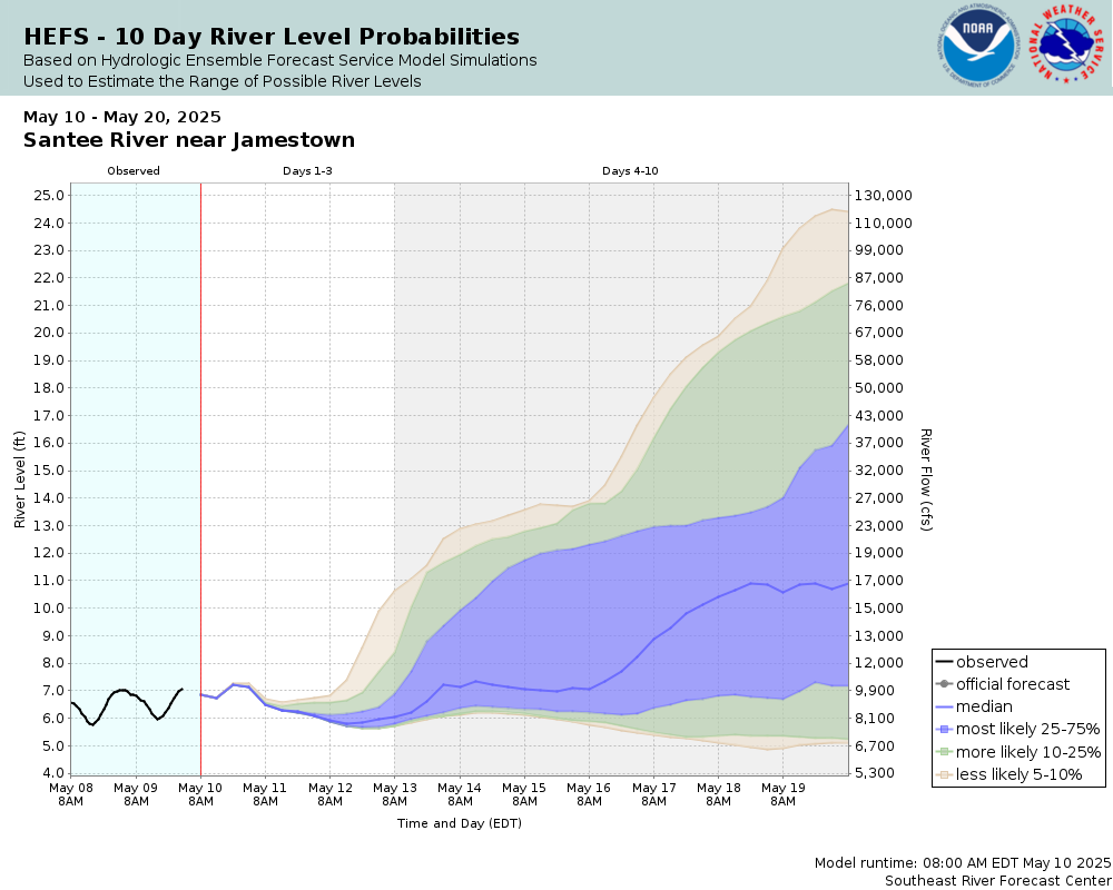
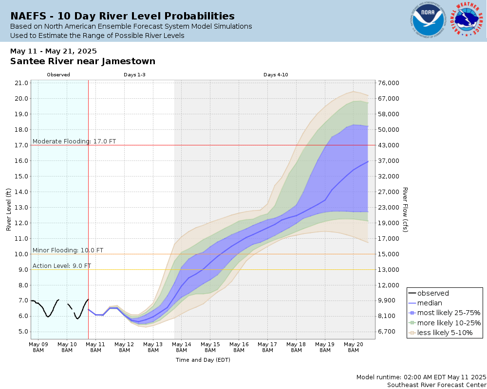
Potential River Levels Used to Estimate the Chance of Flooding and the Range of Possible River Levels |
||
| 10 Day (HEFS) | 10 Day (NAEFS) | 10 Day (GEFS) |
 |
 |
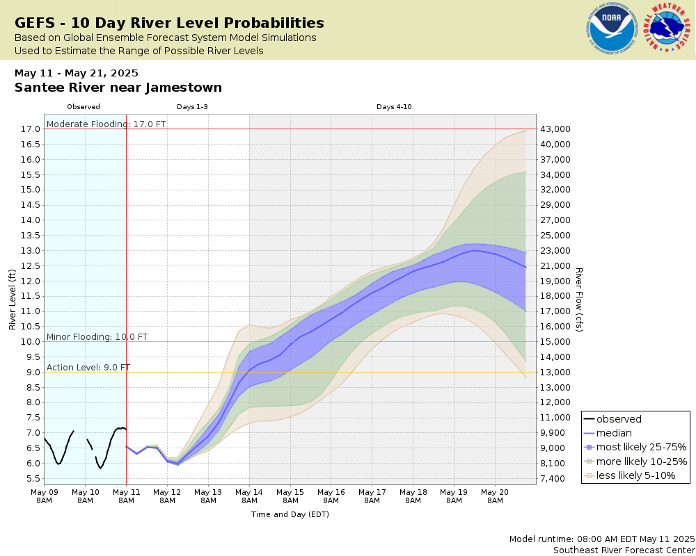 |
Note: Use the official hydrograph at the top of this web page for river levels within the next 72 hours.
Click individual graphics to enlarge.
Collaborative Agencies
The National Weather Service prepares its forecasts and other services in collaboration with agencies like the US Geological Survey, US Bureau of Reclamation, US Army Corps of Engineers, Natural Resource Conservation Service, National Park Service, ALERT Users Group, Bureau of Indian Affairs, and many state and local emergency managers across the country. For details, please click here.