Chattahoochee River near Whitesburg
Future / Actual / Minor
OWP 2.0 WWA Modal Title
01/11/2021, 10:04 PM UTC through 01/11/2021, 10:04 PM UTC
Sender
Sent
- Warning: no valid ratings curve available. Transformations to and from FEET/CFS/KCFS will not happen.
Traces and Thresholds Click to turn on/off display
CATEGORY STAGE Major Flooding 26 ft Moderate Flooding 21 ft Minor Flooding 17 ft Action 15 ft Reliability of the Forecast:
NOTE: Forecasts are issued as needed during times of high water, but are not routinely available.
Flood stage level has recently changed.
River forecasts for this location take into account past precipitation and the precipitation amounts expected approximately 48 hours into the future from the forecast issuance time.
National Water Model Hydrograph
Official NWS streamflow forecasts are produced by NWS hydrologic forecasters for river gauge locations using hydrologic models which are calibrated to that location. This process considers additional guidance and information, including local expertise and experience, to produce the best forecast possible. The NWM output provides supplemental guidance to NWS forecasters and should not be considered an official NWS river forecast.
Flood Impacts
- 34 - Widespread catastrophic flooding occurs. Water reaches the bottom of the U.S. Highway 27 bridge and state officals will close it. Large portions of Plant Yates and Plant Wansley will be flooded out. Numerous homes and roads on both sides of the river will be flooded several feet deep. Transportation in the Whitesburg and Sargent areas will be difficult due to road closures. The day use area...riverside trails and the north camping site in the Chattahoochee Bend State Park will be completely flooded.
- 30 - Record flooding occurs with widespread inundation flooding surrounding the gage. The Riverside Park will flood up to 11 feet deep. Some river intake buildings will be flooded at Plant Yates. Homes at the end of Bob Brewster Road will be flooded several feet deep. Portions of Payton Road near Cliff Payton Circle and a day use area parking lot and north camping site in the Chattahoochee Bend State Park will be under 9 feet of water. A pumping station at Plant Wansley downstream will be flooded.
- 28 - Major flooding continues with widespread inundation flooding surrounding the gage. The Riverside Park will flood up to 9 feet deep. Some river intake buildings flood at Plant Yates near the gage. Some homes at the end of Bob Brewster Road will be flooded a few feet deep. Portions of Payton Road near Cliff Payton Circle and a day use area parking lot and north camping site in the Chattahoochee Bend State Park will be under 7 feet of water. Small coffer dams at Plant Wansley downstream will be flooded.
Gauge Location
Recent Crests
| 1. | 18.59 ft | on 02-14-2025 |
| 2. | 21.45 ft | on 09-28-2024 |
| 3. | 17.55 ft | on 05-05-2021 |
| 4. | 17.07 ft | on 10-12-2020 |
| 5. | 17.63 ft | on 02-07-2020 |
Recent Crests
| 1. | 18.59 ft | on 02-14-2025 |
| 2. | 21.45 ft | on 09-28-2024 |
| 3. | 17.55 ft | on 05-05-2021 |
| 4. | 17.07 ft | on 10-12-2020 |
| 5. | 17.63 ft | on 02-07-2020 |
| 6. | 20.26 ft | on 12-29-2018 |
| 7. | 17.99 ft | on 04-06-2017 |
| 8. | 20.16 ft | on 12-25-2015 |
| 9. | 17.85 ft | on 04-08-2014 |
| 10. | 15.41 ft | on 01-12-2014 |
| 11. | 16.20 ft | on 05-06-2013 |
| 12. | 15.41 ft | on 03-04-2012 |
| 13. | 15.83 ft | on 03-11-2010 |
| 14. | 17.08 ft | on 02-06-2010 |
| 15. | 15.83 ft | on 01-25-2010 |
| 16. | 15.01 ft | on 12-26-2009 |
| 17. | 17.22 ft | on 12-19-2009 |
| 18. | 15.27 ft | on 12-03-2009 |
| 19. | 20.78 ft | on 11-12-2009 |
| 20. | 17.48 ft | on 10-13-2009 |
| 21. | 29.74 ft | on 09-23-2009 |
| 22. | 24.53 ft | on 07-12-2005 |
| 23. | 17.22 ft | on 04-01-2005 |
| 24. | 17.93 ft | on 03-28-2005 |
| 25. | 19.38 ft | on 09-18-2004 |
| 26. | 19.38 ft | on 09-18-2004 |
| 27. | 17.10 ft | on 07-02-2003 |
| 28. | 22.06 ft | on 06-18-2003 |
| 29. | 20.50 ft | on 05-08-2003 |
| 30. | 17.40 ft | on 03-07-2003 |
| 31. | 15.67 ft | on 03-15-2001 |
| 32. | 23.81 ft | on 03-09-1998 |
| 33. | 15.07 ft | on 09-26-1997 |
| 34. | 20.79 ft | on 03-01-1997 |
| 35. | 21.96 ft | on 03-08-1996 |
| 36. | 20.50 ft | on 02-03-1996 |
| 37. | 20.50 ft | on 10-06-1995 |
| 38. | 17.00 ft | on 03-09-1995 |
| 39. | 17.07 ft | on 02-18-1995 |
| 40. | 17.10 ft | on 02-11-1995 |
| 41. | 17.91 ft | on 07-05-1994 |
| 42. | 19.48 ft | on 12-18-1993 |
| 43. | 15.30 ft | on 01-13-1993 |
| 44. | 19.47 ft | on 12-18-1992 |
| 45. | 15.29 ft | on 03-30-1991 |
| 46. | 25.90 ft | on 03-18-1990 |
| 47. | 17.20 ft | on 02-10-1990 |
| 48. | 15.07 ft | on 09-25-1987 |
| 49. | 18.65 ft | on 01-19-1987 |
| 50. | 20.50 ft | on 10-06-1985 |
| 51. | 16.46 ft | on 12-07-1983 |
| 52. | 18.89 ft | on 04-09-1983 |
| 53. | 15.90 ft | on 11-05-1982 |
| 54. | 21.89 ft | on 02-04-1982 |
| 55. | 15.40 ft | on 03-30-1981 |
| 56. | 16.61 ft | on 02-11-1981 |
| 57. | 17.69 ft | on 03-09-1980 |
| 58. | 23.79 ft | on 04-14-1979 |
| 59. | 21.87 ft | on 11-05-1978 |
| 60. | 19.56 ft | on 03-31-1977 |
| 61. | 23.90 ft | on 03-16-1976 |
| 62. | 21.48 ft | on 03-14-1975 |
| 63. | 18.82 ft | on 01-01-1974 |
| 64. | 17.24 ft | on 02-01-1973 |
| 65. | 21.84 ft | on 01-12-1972 |
| 66. | 18.73 ft | on 03-03-1971 |
| 67. | 20.89 ft | on 03-20-1970 |
| 68. | 18.79 ft | on 04-19-1969 |
| 69. | 17.58 ft | on 08-25-1967 |
| 70. | 18.85 ft | on 02-14-1966 |
| 71. | 16.70 ft | on 01-24-1965 |
| 72. | 27.50 ft | on 02-25-1961 |
| 73. | 17.80 ft | on 01-19-1954 |
| 74. | 15.40 ft | on 03-10-1953 |
| 75. | 15.40 ft | on 01-10-1953 |
| 76. | 20.50 ft | on 03-14-1952 |
| 77. | 17.30 ft | on 12-21-1951 |
| 78. | 18.40 ft | on 01-09-1949 |
| 79. | 25.00 ft | on 11-29-1948 |
| 80. | 17.20 ft | on 02-09-1948 |
| 81. | 20.20 ft | on 01-23-1947 |
| 82. | 25.10 ft | on 01-10-1946 |
| 83. | 15.70 ft | on 04-25-1945 |
| 84. | 17.60 ft | on 04-01-1944 |
| 85. | 18.20 ft | on 03-21-1943 |
| 86. | 19.60 ft | on 03-21-1942 |
| 87. | 15.70 ft | on 02-28-1939 |
| 88. | 16.40 ft | on 04-08-1938 |
| 89. | 29.11 ft | on 12-11-1919 |
Historic Crests
| 1. | 29.74 ft | on 09-23-2009 |
| 2. | 29.11 ft | on 12-11-1919 |
| 3. | 27.50 ft | on 02-25-1961 |
| 4. | 25.90 ft | on 03-18-1990 |
| 5. | 25.10 ft | on 01-10-1946 |
Historic Crests
| 1. | 29.74 ft | on 09-23-2009 |
| 2. | 29.11 ft | on 12-11-1919 |
| 3. | 27.50 ft | on 02-25-1961 |
| 4. | 25.90 ft | on 03-18-1990 |
| 5. | 25.10 ft | on 01-10-1946 |
| 6. | 25.00 ft | on 11-29-1948 |
| 7. | 24.53 ft | on 07-12-2005 |
| 8. | 23.90 ft | on 03-16-1976 |
| 9. | 23.81 ft | on 03-09-1998 |
| 10. | 23.79 ft | on 04-14-1979 |
| 11. | 22.06 ft | on 06-18-2003 |
| 12. | 21.96 ft | on 03-08-1996 |
| 13. | 21.89 ft | on 02-04-1982 |
| 14. | 21.87 ft | on 11-05-1978 |
| 15. | 21.84 ft | on 01-12-1972 |
| 16. | 21.48 ft | on 03-14-1975 |
| 17. | 21.45 ft | on 09-28-2024 |
| 18. | 20.89 ft | on 03-20-1970 |
| 19. | 20.79 ft | on 03-01-1997 |
| 20. | 20.78 ft | on 11-12-2009 |
| 21. | 20.50 ft | on 10-06-1985 |
| 22. | 20.50 ft | on 05-08-2003 |
| 23. | 20.50 ft | on 02-03-1996 |
| 24. | 20.50 ft | on 10-06-1995 |
| 25. | 20.50 ft | on 03-14-1952 |
| 26. | 20.26 ft | on 12-29-2018 |
| 27. | 20.20 ft | on 01-23-1947 |
| 28. | 20.16 ft | on 12-25-2015 |
| 29. | 19.60 ft | on 03-21-1942 |
| 30. | 19.56 ft | on 03-31-1977 |
| 31. | 19.48 ft | on 12-18-1993 |
| 32. | 19.47 ft | on 12-18-1992 |
| 33. | 19.38 ft | on 09-18-2004 |
| 34. | 19.38 ft | on 09-18-2004 |
| 35. | 18.89 ft | on 04-09-1983 |
| 36. | 18.85 ft | on 02-14-1966 |
| 37. | 18.82 ft | on 01-01-1974 |
| 38. | 18.79 ft | on 04-19-1969 |
| 39. | 18.73 ft | on 03-03-1971 |
| 40. | 18.65 ft | on 01-19-1987 |
| 41. | 18.59 ft | on 02-14-2025 |
| 42. | 18.40 ft | on 01-09-1949 |
| 43. | 18.20 ft | on 03-21-1943 |
| 44. | 17.99 ft | on 04-06-2017 |
| 45. | 17.93 ft | on 03-28-2005 |
| 46. | 17.91 ft | on 07-05-1994 |
| 47. | 17.85 ft | on 04-08-2014 |
| 48. | 17.80 ft | on 01-19-1954 |
| 49. | 17.69 ft | on 03-09-1980 |
| 50. | 17.63 ft | on 02-07-2020 |
| 51. | 17.60 ft | on 04-01-1944 |
| 52. | 17.58 ft | on 08-25-1967 |
| 53. | 17.55 ft | on 05-05-2021 |
| 54. | 17.48 ft | on 10-13-2009 |
| 55. | 17.40 ft | on 03-07-2003 |
| 56. | 17.30 ft | on 12-21-1951 |
| 57. | 17.24 ft | on 02-01-1973 |
| 58. | 17.22 ft | on 12-19-2009 |
| 59. | 17.22 ft | on 04-01-2005 |
| 60. | 17.20 ft | on 02-09-1948 |
| 61. | 17.20 ft | on 02-10-1990 |
| 62. | 17.10 ft | on 02-11-1995 |
| 63. | 17.10 ft | on 07-02-2003 |
| 64. | 17.08 ft | on 02-06-2010 |
| 65. | 17.07 ft | on 02-18-1995 |
| 66. | 17.07 ft | on 10-12-2020 |
| 67. | 17.00 ft | on 03-09-1995 |
| 68. | 16.70 ft | on 01-24-1965 |
| 69. | 16.61 ft | on 02-11-1981 |
| 70. | 16.46 ft | on 12-07-1983 |
| 71. | 16.40 ft | on 04-08-1938 |
| 72. | 16.20 ft | on 05-06-2013 |
| 73. | 15.90 ft | on 11-05-1982 |
| 74. | 15.83 ft | on 01-25-2010 |
| 75. | 15.83 ft | on 03-11-2010 |
| 76. | 15.70 ft | on 02-28-1939 |
| 77. | 15.70 ft | on 04-25-1945 |
| 78. | 15.67 ft | on 03-15-2001 |
| 79. | 15.41 ft | on 03-04-2012 |
| 80. | 15.41 ft | on 01-12-2014 |
| 81. | 15.40 ft | on 03-10-1953 |
| 82. | 15.40 ft | on 03-30-1981 |
| 83. | 15.40 ft | on 01-10-1953 |
| 84. | 15.30 ft | on 01-13-1993 |
| 85. | 15.29 ft | on 03-30-1991 |
| 86. | 15.27 ft | on 12-03-2009 |
| 87. | 15.07 ft | on 09-26-1997 |
| 88. | 15.07 ft | on 09-25-1987 |
| 89. | 15.01 ft | on 12-26-2009 |
Low Water Records
Low Water Records
Vertical Datum Table
| type | NAVD88 | STND |
|---|---|---|
| major Flooding | 708.20 ft | 26.00 ft |
| moderate Flooding | 703.20 ft | 21.00 ft |
| minor Flooding | 699.20 ft | 17.00 ft |
| action | 697.20 ft | 15.00 ft |
| Latest Value | 686.31 ft | 4.11 ft |
| Gauge Zero | 682.20 ft | 0.00 ft |
Gauge Photos
No Images Found


Unique Local Info
|
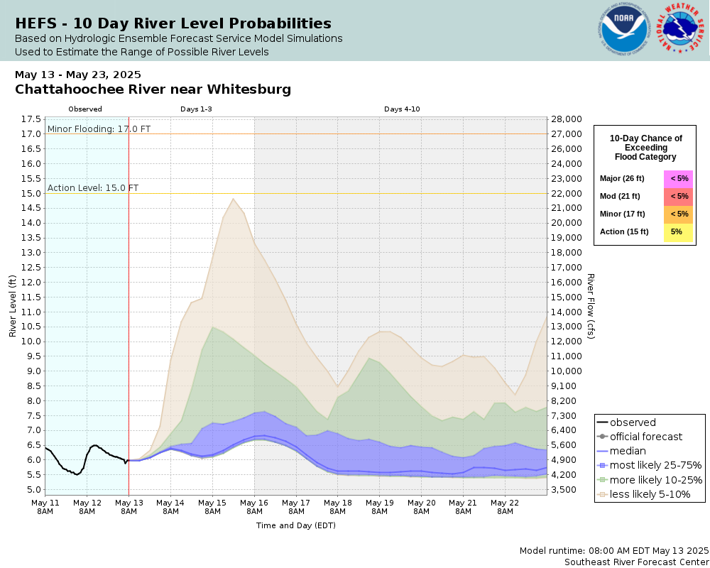
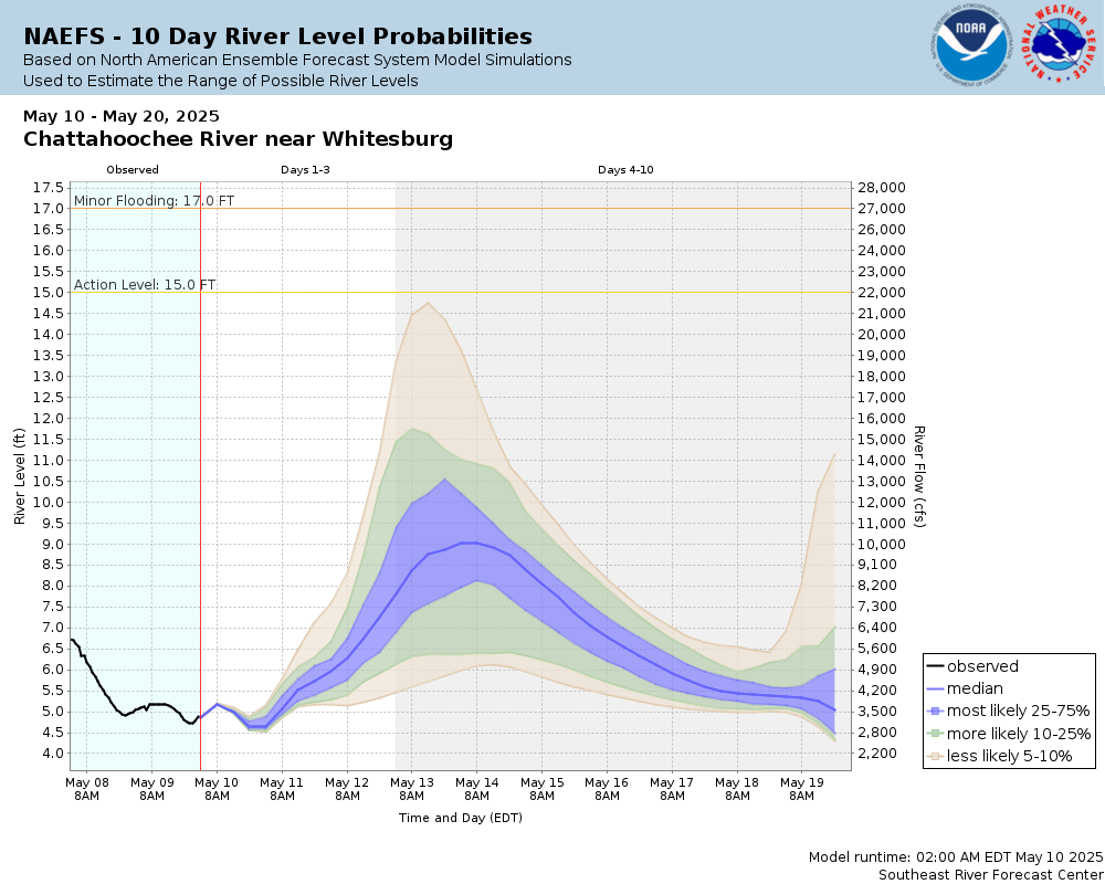
Potential River Levels Used to Estimate the Chance of Flooding and the Range of Possible River Levels |
||
| 10 Day (HEFS) | 7 Day (NAEFS) | 7 Day (GEFS) |
 |
 |
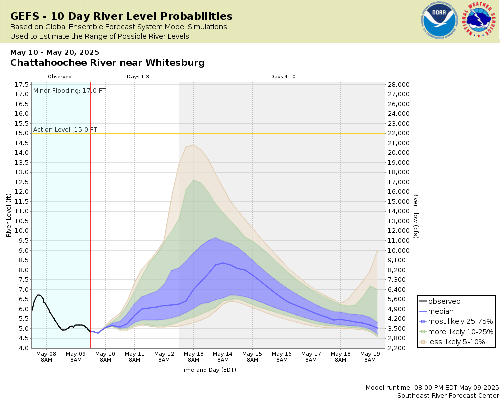 |
Note: Use the official hydrograph at the top of this web page for river levels within the next 72 Hours.
Collaborative Agencies
The National Weather Service prepares its forecasts and other services in collaboration with agencies like the US Geological Survey, US Bureau of Reclamation, US Army Corps of Engineers, Natural Resource Conservation Service, National Park Service, ALERT Users Group, Bureau of Indian Affairs, and many state and local emergency managers across the country. For details, please click here.