Mississippi River at Hannibal
Future / Actual / Minor
OWP 2.0 WWA Modal Title
01/11/2021, 10:04 PM UTC through 01/11/2021, 10:04 PM UTC
Sender
Sent
- Warning: no valid ratings curve available. Transformations to and from FEET/CFS/KCFS will not happen.
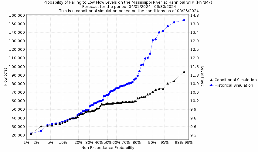
Traces and Thresholds Click to turn on/off display
CATEGORY STAGE Major Flooding 24 ft Moderate Flooding 22 ft Minor Flooding 17 ft Action 15 ft Reliability of the Forecast:
NOTE: Forecasts are issued routinely year-round.
River forecasts for this location take into account past precipitation and the precipitation amounts expected approximately 24 hours into the future from the forecast issuance time.
For the latest navigation status update from the U.S. Army Corps of Engineers-St. Louis District, click here.
National Water Model Hydrograph
Official NWS streamflow forecasts are produced by NWS hydrologic forecasters for river gauge locations using hydrologic models which are calibrated to that location. This process considers additional guidance and information, including local expertise and experience, to produce the best forecast possible. The NWM output provides supplemental guidance to NWS forecasters and should not be considered an official NWS river forecast.
Flood Impacts
- 34 - This is the top of the Hannibal Floodwall.
- 28.2 - The Fabius River levee (Right Bank) is overtopped between River Mile 332.4 and 323.5, flooding 14,200 acres. The Marion County levee is overtopped between River Mile 320.7 and 323.5, flooding 4000 acres.
- 28 - The elevated boat club, outside the levee, floods.
Gauge Info
| Coordinates | 39.7207, -91.3624 |
| RFC | NCRFC |
| State | MO |
| WFO | LSX |
| County | Marion |
| Data Provider(s) | |
| US Army Corps of Engineers | Rivergages.com |
| USGS | 05501600 |
Gauge Location
Recent Crests
| 1. | 18.51 ft | on 04-30-2024 | (P) |
| 2. | 21.89 ft | on 05-06-2023 | |
| 3. | 17.40 ft | on 04-28-2023 | |
| 4. | 17.25 ft | on 06-02-2022 | |
| 5. | 17.03 ft | on 05-07-2022 |
Recent Crests
| 1. | 18.51 ft | on 04-30-2024 | (P) |
| 2. | 21.89 ft | on 05-06-2023 | |
| 3. | 17.40 ft | on 04-28-2023 | |
| 4. | 17.25 ft | on 06-02-2022 | |
| 5. | 17.03 ft | on 05-07-2022 | |
| 6. | 19.03 ft | on 04-12-2021 | |
| 7. | 18.35 ft | on 03-19-2021 | |
| 8. | 18.15 ft | on 07-02-2020 | |
| 9. | 18.79 ft | on 06-11-2020 | |
| 10. | 16.05 ft | on 05-18-2020 | |
| 11. | 20.34 ft | on 04-02-2020 | |
| 12. | 20.82 ft | on 10-17-2019 | |
| 13. | 30.16 ft | on 06-02-2019 | |
| 14. | 24.80 ft | on 10-12-2018 | |
| 15. | 20.61 ft | on 09-09-2018 | |
| 16. | 19.44 ft | on 07-06-2018 | |
| 17. | 19.93 ft | on 05-16-2018 | |
| 18. | 20.33 ft | on 05-03-2017 | |
| 19. | 16.05 ft | on 04-22-2017 | |
| 20. | 18.41 ft | on 04-07-2017 | |
| 21. | 19.80 ft | on 10-07-2016 | |
| 22. | 17.54 ft | on 04-01-2016 | |
| 23. | 17.47 ft | on 01-21-2016 | |
| 24. | 22.16 ft | on 12-29-2015 | |
| 25. | 17.62 ft | on 12-02-2015 | |
| 26. | 16.20 ft | on 07-18-2015 | |
| 27. | 18.85 ft | on 07-13-2015 | |
| 28. | 17.14 ft | on 07-09-2015 | |
| 29. | 23.67 ft | on 06-28-2015 | |
| 30. | 19.36 ft | on 09-12-2014 | |
| 31. | 26.68 ft | on 07-08-2014 | |
| 32. | 17.12 ft | on 06-05-2014 | |
| 33. | 18.57 ft | on 05-16-2014 | |
| 34. | 16.67 ft | on 05-02-2014 | |
| 35. | 25.53 ft | on 06-01-2013 | |
| 36. | 27.63 ft | on 04-21-2013 | |
| 37. | 16.53 ft | on 08-02-2011 | |
| 38. | 20.57 ft | on 06-29-2011 | |
| 39. | 23.59 ft | on 06-17-2011 | |
| 40. | 23.17 ft | on 04-24-2011 | |
| 41. | 16.65 ft | on 02-22-2011 | |
| 42. | 16.48 ft | on 02-18-2011 | |
| 43. | 18.27 ft | on 10-09-2010 | |
| 44. | 22.59 ft | on 06-24-2010 | |
| 45. | 20.16 ft | on 05-15-2010 | |
| 46. | 18.64 ft | on 04-27-2010 | |
| 47. | 20.15 ft | on 03-16-2010 | |
| 48. | 19.96 ft | on 01-24-2010 | |
| 49. | 16.20 ft | on 01-07-2010 | |
| 50. | 16.43 ft | on 01-03-2010 | |
| 51. | 19.78 ft | on 11-01-2009 | |
| 52. | 16.06 ft | on 06-26-2009 | |
| 53. | 21.09 ft | on 05-17-2009 | |
| 54. | 16.18 ft | on 03-29-2009 | |
| 55. | 22.15 ft | on 03-12-2009 | |
| 56. | 22.15 ft | on 03-12-2009 | |
| 57. | 18.83 ft | on 09-15-2008 | |
| 58. | 16.12 ft | on 07-31-2008 | |
| 59. | 16.11 ft | on 07-26-2008 | |
| 60. | 29.54 ft | on 06-18-2008 | |
| 61. | 23.26 ft | on 05-05-2008 | |
| 62. | 21.46 ft | on 04-28-2008 | |
| 63. | 16.06 ft | on 03-24-2008 | |
| 64. | 16.06 ft | on 02-18-2008 | |
| 65. | 18.55 ft | on 08-27-2007 | |
| 66. | 16.29 ft | on 05-09-2007 | |
| 67. | 17.45 ft | on 04-28-2007 | |
| 68. | 18.16 ft | on 04-14-2007 | |
| 69. | 17.20 ft | on 03-27-2007 | |
| 70. | 15.51 ft | on 04-18-2006 | |
| 71. | 16.44 ft | on 04-14-2005 | |
| 72. | 21.07 ft | on 06-04-2004 | |
| 73. | 17.45 ft | on 05-26-2003 | |
| 74. | 21.41 ft | on 05-13-2002 | |
| 75. | 16.80 ft | on 06-17-2001 | |
| 76. | 26.91 ft | on 05-16-2001 | |
| 77. | 23.30 ft | on 04-28-2001 | |
| 78. | 18.62 ft | on 06-27-2000 | |
| 79. | 19.60 ft | on 07-09-1998 | |
| 80. | 23.48 ft | on 04-15-1998 | |
| 81. | 20.80 ft | on 04-22-1997 | |
| 82. | 19.10 ft | on 02-27-1997 | |
| 83. | 24.41 ft | on 05-29-1996 | |
| 84. | 21.90 ft | on 05-18-1995 | |
| 85. | 31.80 ft | on 07-15-1993 | |
| 86. | 19.50 ft | on 03-08-1993 | |
| 87. | 18.20 ft | on 05-02-1992 | |
| 88. | 22.20 ft | on 06-23-1990 | |
| 89. | 25.30 ft | on 10-04-1986 | |
| 90. | 22.30 ft | on 05-20-1986 | |
| 91. | 17.00 ft | on 11-16-1985 | |
| 92. | 23.10 ft | on 03-05-1985 | |
| 93. | 18.60 ft | on 06-30-1984 | |
| 94. | 18.33 ft | on 05-02-1983 | |
| 95. | 23.90 ft | on 04-05-1983 | |
| 96. | 20.00 ft | on 12-04-1982 | |
| 97. | 20.60 ft | on 04-19-1982 | |
| 98. | 23.00 ft | on 04-13-1979 | |
| 99. | 22.00 ft | on 04-27-1976 | |
| 100. | 23.27 ft | on 05-22-1974 | |
| 101. | 28.59 ft | on 04-25-1973 | 1 |
| 102. | 17.50 ft | on 05-02-1972 | 1 |
| 103. | 16.80 ft | on 04-28-1971 | 1 |
| 104. | 17.50 ft | on 02-27-1971 | 1 |
| 105. | 22.50 ft | on 07-11-1969 | 1 |
| 106. | 20.50 ft | on 05-01-1969 | 1 |
| 107. | 16.20 ft | on 06-18-1967 | 1 |
| 108. | 19.70 ft | on 04-17-1967 | 1 |
| 109. | 19.90 ft | on 09-26-1965 | 1 |
| 110. | 24.59 ft | on 05-01-1965 | 1 |
| 111. | 17.10 ft | on 03-19-1965 | 1 |
| 112. | 20.90 ft | on 04-09-1962 | 1 |
| 113. | 16.60 ft | on 11-17-1961 | 1 |
| 114. | 16.30 ft | on 09-16-1961 | 1 |
| 115. | 19.10 ft | on 04-07-1961 | 1 |
| 116. | 18.80 ft | on 05-13-1960 | 1 |
| 117. | 23.40 ft | on 04-04-1960 | 1 |
| 118. | 16.40 ft | on 04-06-1959 | 1 |
| 119. | 16.20 ft | on 04-02-1959 | 1 |
| 120. | 16.50 ft | on 07-02-1954 | 1 |
| 121. | 16.00 ft | on 05-19-1954 | 1 |
| 122. | 16.60 ft | on 03-30-1953 | 1 |
| 123. | 21.60 ft | on 04-25-1952 | 1 |
| 124. | 16.90 ft | on 03-16-1952 | 1 |
| 125. | 17.30 ft | on 07-16-1951 | 1 |
| 126. | 22.60 ft | on 05-13-1951 | 1 |
| 127. | 19.20 ft | on 06-22-1950 | 1 |
| 128. | 16.30 ft | on 04-27-1950 | 1 |
| 129. | 21.60 ft | on 03-24-1948 | 1 |
| 130. | 24.10 ft | on 06-09-1947 | 1 |
| 131. | 18.90 ft | on 04-23-1947 | 1 |
| 132. | 17.10 ft | on 06-21-1946 | 1 |
| 133. | 18.70 ft | on 03-26-1946 | 1 |
| 134. | 19.30 ft | on 01-12-1946 | 1 |
| 135. | 19.80 ft | on 06-18-1945 | |
| 136. | 18.40 ft | on 05-18-1945 | 1 |
| 137. | 16.20 ft | on 04-19-1945 | 1 |
| 138. | 19.80 ft | on 03-27-1945 | 1 |
| 139. | 19.20 ft | on 06-24-1944 | 1 |
| 140. | 22.50 ft | on 05-28-1944 | 1 |
| 141. | 19.50 ft | on 04-26-1944 | 1 |
| 142. | 16.90 ft | on 03-17-1944 | 1 |
| 143. | 16.80 ft | on 07-06-1943 | 1 |
| 144. | 17.60 ft | on 06-18-1943 | 1 |
| 145. | 17.10 ft | on 05-21-1943 | 1 |
| 146. | 16.30 ft | on 03-10-1943 | 1 |
| 147. | 17.70 ft | on 06-19-1942 | 1 |
| 148. | 17.80 ft | on 04-18-1939 | 1 |
| 149. | 18.00 ft | on 03-15-1939 | 1 |
| 150. | 18.00 ft | on 09-27-1938 | 1 |
| 151. | 17.70 ft | on 03-12-1937 | 1 |
| 152. | 16.20 ft | on 06-04-1935 | 1 |
| 153. | 22.08 ft | on 04-28-1929 | 1 |
| 154. | 17.66 ft | on 11-18-1928 | 1 |
| 155. | 17.00 ft | on 06-06-1927 | 1 |
| 156. | 17.92 ft | on 04-22-1927 | 1 |
| 157. | 16.50 ft | on 04-04-1927 | 1 |
| 158. | 16.66 ft | on 10-03-1926 | 1 |
| 159. | 18.80 ft | on 04-25-1922 | 1 |
| 160. | 19.50 ft | on 04-22-1920 | 1 |
| 161. | 16.60 ft | on 03-29-1920 | 1 |
| 162. | 20.10 ft | on 05-08-1919 | 1 |
| 163. | 17.90 ft | on 04-28-1919 | 1 |
| 164. | 16.25 ft | on 03-22-1919 | 1 |
| 165. | 17.70 ft | on 06-13-1918 | 1 |
| 166. | 18.10 ft | on 06-09-1917 | 1 |
| 167. | 16.10 ft | on 05-03-1917 | 1 |
| 168. | 16.90 ft | on 06-10-1916 | 1 |
| 169. | 16.45 ft | on 05-29-1916 | 1 |
| 170. | 16.05 ft | on 05-26-1916 | 1 |
| 171. | 19.15 ft | on 05-16-1916 | 1 |
| 172. | 16.20 ft | on 04-22-1916 | 1 |
| 173. | 18.30 ft | on 03-31-1916 | 1 |
| 174. | 16.10 ft | on 08-05-1915 | 1 |
| 175. | 19.00 ft | on 04-08-1912 | 1 |
| 176. | 16.50 ft | on 07-10-1909 | 1 |
| 177. | 17.60 ft | on 06-01-1908 | 1 |
| 178. | 18.10 ft | on 06-13-1905 | 1 |
| 179. | 22.54 ft | on 06-08-1903 | 1 |
| 180. | 16.60 ft | on 07-23-1902 | 1 |
| 181. | 20.80 ft | on 04-29-1897 | 1 |
| 182. | 16.60 ft | on 04-01-1897 | 1 |
| 183. | 16.80 ft | on 05-28-1893 | 1 |
| 184. | 16.10 ft | on 05-17-1893 | 1 |
| 185. | 20.80 ft | on 07-03-1892 | 1 |
| 186. | 19.80 ft | on 06-06-1892 | 1 |
| 187. | 18.50 ft | on 05-09-1892 | 1 |
| 188. | 17.10 ft | on 05-09-1886 | 1 |
| 189. | 18.50 ft | on 04-03-1884 | 1 |
| 190. | 17.60 ft | on 05-20-1883 | 1 |
| 191. | 18.40 ft | on 07-02-1882 | 1 |
| 192. | 17.20 ft | on 06-05-1882 | 1 |
| 193. | 17.60 ft | on 05-09-1882 | 1 |
| 194. | 18.20 ft | on 04-27-1882 | 1 |
| 195. | 20.40 ft | on 10-22-1881 | 1 |
| 196. | 16.80 ft | on 07-20-1881 | 1 |
| 197. | 16.70 ft | on 05-20-1881 | 1 |
| 198. | 19.10 ft | on 04-05-1881 | 1 |
| 199. | 18.70 ft | on 07-03-1880 | 1 |
Historic Crests
| 1. | 31.80 ft | on 07-15-1993 | |
| 2. | 30.16 ft | on 06-02-2019 | |
| 3. | 29.54 ft | on 06-18-2008 | |
| 4. | 28.59 ft | on 04-25-1973 | 1 |
| 5. | 27.63 ft | on 04-21-2013 |
Historic Crests
| 1. | 31.80 ft | on 07-15-1993 | |
| 2. | 30.16 ft | on 06-02-2019 | |
| 3. | 29.54 ft | on 06-18-2008 | |
| 4. | 28.59 ft | on 04-25-1973 | 1 |
| 5. | 27.63 ft | on 04-21-2013 | |
| 6. | 26.91 ft | on 05-16-2001 | |
| 7. | 26.68 ft | on 07-08-2014 | |
| 8. | 25.53 ft | on 06-01-2013 | |
| 9. | 25.30 ft | on 10-04-1986 | |
| 10. | 24.80 ft | on 10-12-2018 | |
| 11. | 24.59 ft | on 05-01-1965 | 1 |
| 12. | 24.41 ft | on 05-29-1996 | |
| 13. | 24.10 ft | on 06-09-1947 | 1 |
| 14. | 23.90 ft | on 04-05-1983 | |
| 15. | 23.67 ft | on 06-28-2015 | |
| 16. | 23.59 ft | on 06-17-2011 | |
| 17. | 23.48 ft | on 04-15-1998 | |
| 18. | 23.40 ft | on 04-04-1960 | 1 |
| 19. | 23.30 ft | on 04-28-2001 | |
| 20. | 23.27 ft | on 05-22-1974 | |
| 21. | 23.26 ft | on 05-05-2008 | |
| 22. | 23.17 ft | on 04-24-2011 | |
| 23. | 23.10 ft | on 03-05-1985 | |
| 24. | 23.00 ft | on 04-13-1979 | |
| 25. | 22.60 ft | on 05-13-1951 | 1 |
| 26. | 22.59 ft | on 06-24-2010 | |
| 27. | 22.54 ft | on 06-08-1903 | 1 |
| 28. | 22.50 ft | on 07-11-1969 | 1 |
| 29. | 22.50 ft | on 05-28-1944 | 1 |
| 30. | 22.30 ft | on 05-20-1986 | |
| 31. | 22.20 ft | on 06-23-1990 | |
| 32. | 22.16 ft | on 12-29-2015 | |
| 33. | 22.15 ft | on 03-12-2009 | |
| 34. | 22.15 ft | on 03-12-2009 | |
| 35. | 22.08 ft | on 04-28-1929 | 1 |
| 36. | 22.00 ft | on 04-27-1976 | |
| 37. | 21.90 ft | on 05-18-1995 | |
| 38. | 21.89 ft | on 05-06-2023 | |
| 39. | 21.60 ft | on 03-24-1948 | 1 |
| 40. | 21.60 ft | on 04-25-1952 | 1 |
| 41. | 21.46 ft | on 04-28-2008 | |
| 42. | 21.41 ft | on 05-13-2002 | |
| 43. | 21.09 ft | on 05-17-2009 | |
| 44. | 21.07 ft | on 06-04-2004 | |
| 45. | 20.90 ft | on 04-09-1962 | 1 |
| 46. | 20.82 ft | on 10-17-2019 | |
| 47. | 20.80 ft | on 04-22-1997 | |
| 48. | 20.80 ft | on 04-29-1897 | 1 |
| 49. | 20.80 ft | on 07-03-1892 | 1 |
| 50. | 20.61 ft | on 09-09-2018 | |
| 51. | 20.60 ft | on 04-19-1982 | |
| 52. | 20.57 ft | on 06-29-2011 | |
| 53. | 20.50 ft | on 05-01-1969 | 1 |
| 54. | 20.40 ft | on 10-22-1881 | 1 |
| 55. | 20.34 ft | on 04-02-2020 | |
| 56. | 20.33 ft | on 05-03-2017 | |
| 57. | 20.16 ft | on 05-15-2010 | |
| 58. | 20.15 ft | on 03-16-2010 | |
| 59. | 20.10 ft | on 05-08-1919 | 1 |
| 60. | 20.00 ft | on 12-04-1982 | |
| 61. | 19.96 ft | on 01-24-2010 | |
| 62. | 19.93 ft | on 05-16-2018 | |
| 63. | 19.90 ft | on 09-26-1965 | 1 |
| 64. | 19.80 ft | on 03-27-1945 | 1 |
| 65. | 19.80 ft | on 10-07-2016 | |
| 66. | 19.80 ft | on 06-18-1945 | |
| 67. | 19.80 ft | on 06-06-1892 | 1 |
| 68. | 19.78 ft | on 11-01-2009 | |
| 69. | 19.70 ft | on 04-17-1967 | 1 |
| 70. | 19.60 ft | on 07-09-1998 | |
| 71. | 19.50 ft | on 04-22-1920 | 1 |
| 72. | 19.50 ft | on 04-26-1944 | 1 |
| 73. | 19.50 ft | on 03-08-1993 | |
| 74. | 19.44 ft | on 07-06-2018 | |
| 75. | 19.36 ft | on 09-12-2014 | |
| 76. | 19.30 ft | on 01-12-1946 | 1 |
| 77. | 19.20 ft | on 06-22-1950 | 1 |
| 78. | 19.20 ft | on 06-24-1944 | 1 |
| 79. | 19.15 ft | on 05-16-1916 | 1 |
| 80. | 19.10 ft | on 04-07-1961 | 1 |
| 81. | 19.10 ft | on 04-05-1881 | 1 |
| 82. | 19.10 ft | on 02-27-1997 | |
| 83. | 19.03 ft | on 04-12-2021 | |
| 84. | 19.00 ft | on 04-08-1912 | 1 |
| 85. | 18.90 ft | on 04-23-1947 | 1 |
| 86. | 18.85 ft | on 07-13-2015 | |
| 87. | 18.83 ft | on 09-15-2008 | |
| 88. | 18.80 ft | on 05-13-1960 | 1 |
| 89. | 18.80 ft | on 04-25-1922 | 1 |
| 90. | 18.79 ft | on 06-11-2020 | |
| 91. | 18.70 ft | on 03-26-1946 | 1 |
| 92. | 18.70 ft | on 07-03-1880 | 1 |
| 93. | 18.64 ft | on 04-27-2010 | |
| 94. | 18.62 ft | on 06-27-2000 | |
| 95. | 18.60 ft | on 06-30-1984 | |
| 96. | 18.57 ft | on 05-16-2014 | |
| 97. | 18.55 ft | on 08-27-2007 | |
| 98. | 18.51 ft | on 04-30-2024 | (P) |
| 99. | 18.50 ft | on 05-09-1892 | 1 |
| 100. | 18.50 ft | on 04-03-1884 | 1 |
| 101. | 18.41 ft | on 04-07-2017 | |
| 102. | 18.40 ft | on 05-18-1945 | 1 |
| 103. | 18.40 ft | on 07-02-1882 | 1 |
| 104. | 18.35 ft | on 03-19-2021 | |
| 105. | 18.33 ft | on 05-02-1983 | |
| 106. | 18.30 ft | on 03-31-1916 | 1 |
| 107. | 18.27 ft | on 10-09-2010 | |
| 108. | 18.20 ft | on 04-27-1882 | 1 |
| 109. | 18.20 ft | on 05-02-1992 | |
| 110. | 18.16 ft | on 04-14-2007 | |
| 111. | 18.15 ft | on 07-02-2020 | |
| 112. | 18.10 ft | on 06-09-1917 | 1 |
| 113. | 18.10 ft | on 06-13-1905 | 1 |
| 114. | 18.00 ft | on 03-15-1939 | 1 |
| 115. | 18.00 ft | on 09-27-1938 | 1 |
| 116. | 17.92 ft | on 04-22-1927 | 1 |
| 117. | 17.90 ft | on 04-28-1919 | 1 |
| 118. | 17.80 ft | on 04-18-1939 | 1 |
| 119. | 17.70 ft | on 06-19-1942 | 1 |
| 120. | 17.70 ft | on 03-12-1937 | 1 |
| 121. | 17.70 ft | on 06-13-1918 | 1 |
| 122. | 17.66 ft | on 11-18-1928 | 1 |
| 123. | 17.62 ft | on 12-02-2015 | |
| 124. | 17.60 ft | on 06-01-1908 | 1 |
| 125. | 17.60 ft | on 05-09-1882 | 1 |
| 126. | 17.60 ft | on 06-18-1943 | 1 |
| 127. | 17.60 ft | on 05-20-1883 | 1 |
| 128. | 17.54 ft | on 04-01-2016 | |
| 129. | 17.50 ft | on 05-02-1972 | 1 |
| 130. | 17.50 ft | on 02-27-1971 | 1 |
| 131. | 17.47 ft | on 01-21-2016 | |
| 132. | 17.45 ft | on 05-26-2003 | |
| 133. | 17.45 ft | on 04-28-2007 | |
| 134. | 17.40 ft | on 04-28-2023 | |
| 135. | 17.30 ft | on 07-16-1951 | 1 |
| 136. | 17.25 ft | on 06-02-2022 | |
| 137. | 17.20 ft | on 03-27-2007 | |
| 138. | 17.20 ft | on 06-05-1882 | 1 |
| 139. | 17.14 ft | on 07-09-2015 | |
| 140. | 17.12 ft | on 06-05-2014 | |
| 141. | 17.10 ft | on 06-21-1946 | 1 |
| 142. | 17.10 ft | on 05-21-1943 | 1 |
| 143. | 17.10 ft | on 03-19-1965 | 1 |
| 144. | 17.10 ft | on 05-09-1886 | 1 |
| 145. | 17.03 ft | on 05-07-2022 | |
| 146. | 17.00 ft | on 06-06-1927 | 1 |
| 147. | 17.00 ft | on 11-16-1985 | |
| 148. | 16.90 ft | on 03-16-1952 | 1 |
| 149. | 16.90 ft | on 03-17-1944 | 1 |
| 150. | 16.90 ft | on 06-10-1916 | 1 |
| 151. | 16.80 ft | on 04-28-1971 | 1 |
| 152. | 16.80 ft | on 06-17-2001 | |
| 153. | 16.80 ft | on 05-28-1893 | 1 |
| 154. | 16.80 ft | on 07-06-1943 | 1 |
| 155. | 16.80 ft | on 07-20-1881 | 1 |
| 156. | 16.70 ft | on 05-20-1881 | 1 |
| 157. | 16.67 ft | on 05-02-2014 | |
| 158. | 16.66 ft | on 10-03-1926 | 1 |
| 159. | 16.65 ft | on 02-22-2011 | |
| 160. | 16.60 ft | on 03-29-1920 | 1 |
| 161. | 16.60 ft | on 04-01-1897 | 1 |
| 162. | 16.60 ft | on 11-17-1961 | 1 |
| 163. | 16.60 ft | on 03-30-1953 | 1 |
| 164. | 16.60 ft | on 07-23-1902 | 1 |
| 165. | 16.53 ft | on 08-02-2011 | |
| 166. | 16.50 ft | on 07-02-1954 | 1 |
| 167. | 16.50 ft | on 07-10-1909 | 1 |
| 168. | 16.50 ft | on 04-04-1927 | 1 |
| 169. | 16.48 ft | on 02-18-2011 | |
| 170. | 16.45 ft | on 05-29-1916 | 1 |
| 171. | 16.44 ft | on 04-14-2005 | |
| 172. | 16.43 ft | on 01-03-2010 | |
| 173. | 16.40 ft | on 04-06-1959 | 1 |
| 174. | 16.30 ft | on 09-16-1961 | 1 |
| 175. | 16.30 ft | on 03-10-1943 | 1 |
| 176. | 16.30 ft | on 04-27-1950 | 1 |
| 177. | 16.29 ft | on 05-09-2007 | |
| 178. | 16.25 ft | on 03-22-1919 | 1 |
| 179. | 16.20 ft | on 01-07-2010 | |
| 180. | 16.20 ft | on 07-18-2015 | |
| 181. | 16.20 ft | on 06-18-1967 | 1 |
| 182. | 16.20 ft | on 04-02-1959 | 1 |
| 183. | 16.20 ft | on 04-19-1945 | 1 |
| 184. | 16.20 ft | on 06-04-1935 | 1 |
| 185. | 16.20 ft | on 04-22-1916 | 1 |
| 186. | 16.18 ft | on 03-29-2009 | |
| 187. | 16.12 ft | on 07-31-2008 | |
| 188. | 16.11 ft | on 07-26-2008 | |
| 189. | 16.10 ft | on 05-03-1917 | 1 |
| 190. | 16.10 ft | on 08-05-1915 | 1 |
| 191. | 16.10 ft | on 05-17-1893 | 1 |
| 192. | 16.06 ft | on 02-18-2008 | |
| 193. | 16.06 ft | on 03-24-2008 | |
| 194. | 16.06 ft | on 06-26-2009 | |
| 195. | 16.05 ft | on 05-26-1916 | 1 |
| 196. | 16.05 ft | on 05-18-2020 | |
| 197. | 16.05 ft | on 04-22-2017 | |
| 198. | 16.00 ft | on 05-19-1954 | 1 |
| 199. | 15.51 ft | on 04-18-2006 |


Unique Local Info
Collaborative Agencies
The National Weather Service prepares its forecasts and other services in collaboration with agencies like the US Geological Survey, US Bureau of Reclamation, US Army Corps of Engineers, Natural Resource Conservation Service, National Park Service, ALERT Users Group, Bureau of Indian Affairs, and many state and local emergency managers across the country. For details, please click here.