Spring River (AR) at Hardy
Future / Actual / Minor
OWP 2.0 WWA Modal Title
01/11/2021, 10:04 PM UTC through 01/11/2021, 10:04 PM UTC
Sender
Sent
- Upstream gauge unavailableWarning: no valid ratings curve available. Transformations to and from FEET/CFS/KCFS will not happen.
Traces and Thresholds Click to turn on/off display
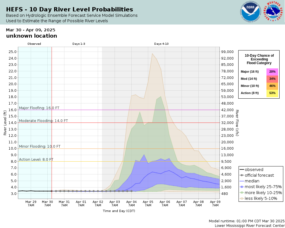
CATEGORY STAGE Major Flooding 16 ft Moderate Flooding 14 ft Minor Flooding 10 ft Action 8 ft Reliability of the Forecast:
NOTE: Forecasts are issued routinely year-round.
River forecasts for this location take into account past precipitation and the precipitation amounts expected approximately 24 hours into the future from the forecast issuance time.
National Water Model Hydrograph
Official NWS streamflow forecasts are produced by NWS hydrologic forecasters for river gauge locations using hydrologic models which are calibrated to that location. This process considers additional guidance and information, including local expertise and experience, to produce the best forecast possible. The NWM output provides supplemental guidance to NWS forecasters and should not be considered an official NWS river forecast.
Flood Impacts
- 22 - Flood in April 2025 rose to 22.8 feet. Expect water over U.S. Highway 63 on the east side of town. Lower lying businesses in Old Town and City Hall flooded. Water over Spring Street at bridge. Water over railroad.
- 20 - Portions of Old Town flooded. Spring Street flooded. Water under most elevated homes along the river bank.
- 18 - Life threatening situation. Homes and businesses along the river and tributaries will be flooded. Water will begin impacting lower lying businesses in Old Town and City Hall. Water over railroad.
Gauge Location
Recent Crests
| 1. | 22.82 ft | on 04-05-2025 |
| 2. | 10.93 ft | on 03-24-2023 |
| 3. | 13.19 ft | on 03-03-2023 |
| 4. | 10.28 ft | on 02-08-2023 |
| 5. | 11.79 ft | on 05-05-2017 |
Recent Crests
| 1. | 22.82 ft | on 04-05-2025 | |
| 2. | 10.93 ft | on 03-24-2023 | |
| 3. | 13.19 ft | on 03-03-2023 | |
| 4. | 10.28 ft | on 02-08-2023 | |
| 5. | 11.79 ft | on 05-05-2017 | |
| 6. | 16.65 ft | on 04-30-2017 | |
| 7. | 15.60 ft | on 12-28-2015 | |
| 8. | 15.60 ft | on 12-28-2015 | |
| 9. | 11.21 ft | on 03-13-2015 | |
| 10. | 20.71 ft | on 04-26-2011 | |
| 11. | 17.41 ft | on 10-30-2009 | |
| 12. | 20.81 ft | on 04-11-2008 | |
| 13. | 22.29 ft | on 03-19-2008 | |
| 14. | 11.11 ft | on 01-15-2007 | |
| 15. | 16.75 ft | on 09-23-2006 | (P) |
| 16. | 9.71 ft | on 01-13-2005 | |
| 17. | 14.66 ft | on 11-18-2003 | |
| 18. | 11.48 ft | on 03-20-2002 | |
| 19. | 29.00 ft | on 12-03-1982 | (P) |
Historic Crests
| 1. | 29.00 ft | on 12-03-1982 | (P) |
| 2. | 22.82 ft | on 04-05-2025 | |
| 3. | 22.29 ft | on 03-19-2008 | |
| 4. | 20.81 ft | on 04-11-2008 | |
| 5. | 20.71 ft | on 04-26-2011 |
Historic Crests
| 1. | 29.00 ft | on 12-03-1982 | (P) |
| 2. | 22.82 ft | on 04-05-2025 | |
| 3. | 22.29 ft | on 03-19-2008 | |
| 4. | 20.81 ft | on 04-11-2008 | |
| 5. | 20.71 ft | on 04-26-2011 | |
| 6. | 17.41 ft | on 10-30-2009 | |
| 7. | 16.75 ft | on 09-23-2006 | (P) |
| 8. | 16.65 ft | on 04-30-2017 | |
| 9. | 15.60 ft | on 12-28-2015 | |
| 10. | 15.60 ft | on 12-28-2015 | |
| 11. | 14.66 ft | on 11-18-2003 | |
| 12. | 13.19 ft | on 03-03-2023 | |
| 13. | 11.79 ft | on 05-05-2017 | |
| 14. | 11.48 ft | on 03-20-2002 | |
| 15. | 11.21 ft | on 03-13-2015 | |
| 16. | 11.11 ft | on 01-15-2007 | |
| 17. | 10.93 ft | on 03-24-2023 | |
| 18. | 10.28 ft | on 02-08-2023 | |
| 19. | 9.71 ft | on 01-13-2005 |
Gauge Photos
No Images Found

Unique Local Info
Flash Flood Warnings will be issued for the Spring River in Fulton and Sharp Counties based on rainfall estimates.
Collaborative Agencies
The National Weather Service prepares its forecasts and other services in collaboration with agencies like the US Geological Survey, US Bureau of Reclamation, US Army Corps of Engineers, Natural Resource Conservation Service, National Park Service, ALERT Users Group, Bureau of Indian Affairs, and many state and local emergency managers across the country. For details, please click here.