Cumberland River at Carthage
Future / Actual / Minor
OWP 2.0 WWA Modal Title
01/11/2021, 10:04 PM UTC through 01/11/2021, 10:04 PM UTC
Sender
Sent
- Warning: no valid ratings curve available. Transformations to and from FEET/CFS/KCFS will not happen.
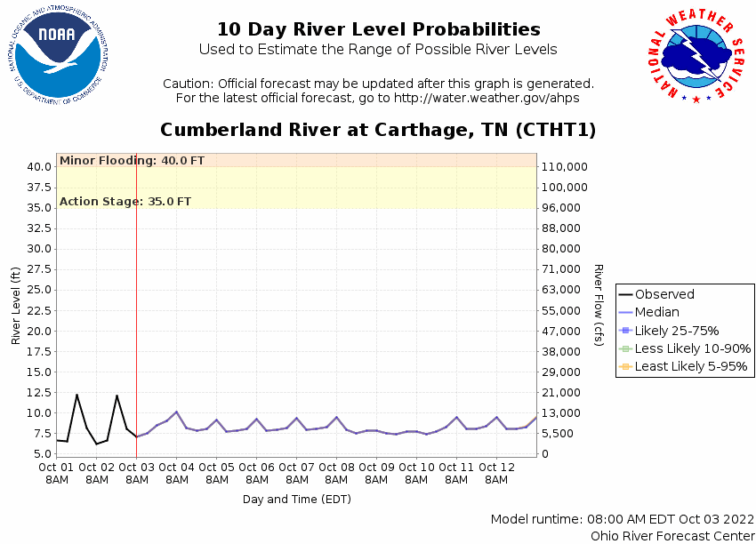
Traces and Thresholds Click to turn on/off display
CATEGORY STAGE Major Flooding 47 ft Moderate Flooding 43 ft Minor Flooding 40 ft Action 35 ft Reliability of the Forecast: Based on current and forecast river, weather and reservoir conditions
NOTE: Forecasts are issued routinely year-round.
Gauge reading affected by reservoir operations.
National Water Model Hydrograph
Official NWS streamflow forecasts are produced by NWS hydrologic forecasters for river gauge locations using hydrologic models which are calibrated to that location. This process considers additional guidance and information, including local expertise and experience, to produce the best forecast possible. The NWM output provides supplemental guidance to NWS forecasters and should not be considered an official NWS river forecast.
Flood Impacts
- 50 - Significant flooding is occurring along the river and the adjacent tributaries, affecting residential, commercial, and industrial areas in and near Carthage, Hartsville, and along the Caney Fork near Gordonsville. Water is impacting many properties west of Main St in Carthage, covering the Gordonsville Hwy at the Smith County Ag Center, and approaching the Dixon Springs Hwy near Riddleton. In Hartsville, flooding of numerous structures near Main St and Broadway is occurring.
- 47 - Flooding along the river and adjacent tributaries is affecting residential, commercial, and industrial areas. In Carthage, water approaches Hwy 25 at Myers St and Upper Ferry Rd, and is flooding numerous properties west of Main St. In Hartsville, significant flooding of structures near Main St and Broadway begins, and water is covering Latti Reese Rd and Lock 6 Rd. Near Gordonsville, water approaches Gordonsville Hwy at the Ag Center, and water reaches the Bonnell Aluminum plant building.
- 45 - Flooding continues to impact agricultural, residential, and commercial properties along the river and the adjcent tributaries. In Carthage, many properties along Upper Ferry Rd and west of Main St area impacted. In Hartsville, properties and structures near Main St and Broadway, as well as homes on River Front Estates Rd and Latti Reese Rd are impacted. Water begins to impact property at the Bonnell Aluminum plant near Grodonsville, and approaches Cumberland Mine Rd near Carthage.
Gauge Info
| Coordinates | 36.2481, -85.9553 |
| RFC | OHRFC |
| State | TN |
| WFO | OHX |
| County | Smith |
| Data Provider(s) | |
| US Geological Survey | USGS--Water Resources of the United States |
| USGS | 03425000 |
Gauge Location
Recent Crests
| 1. | 46.10 ft | on 05-03-2010 |
| 2. | 25.57 ft | on 01-23-2006 |
| 3. | 31.86 ft | on 12-01-2004 |
| 4. | 34.30 ft | on 05-08-2003 |
| 5. | 32.10 ft | on 02-16-2003 |
Recent Crests
| 1. | 46.10 ft | on 05-03-2010 |
| 2. | 25.57 ft | on 01-23-2006 |
| 3. | 31.86 ft | on 12-01-2004 |
| 4. | 34.30 ft | on 05-08-2003 |
| 5. | 32.10 ft | on 02-16-2003 |
| 6. | 30.43 ft | on 03-18-2002 |
| 7. | 33.04 ft | on 02-19-1991 |
| 8. | 30.31 ft | on 02-04-1990 |
| 9. | 39.72 ft | on 03-06-1989 |
| 10. | 40.20 ft | on 05-08-1984 |
| 11. | 30.04 ft | on 05-19-1983 |
| 12. | 35.13 ft | on 03-21-1980 |
| 13. | 47.95 ft | on 03-14-1975 |
| 14. | 45.20 ft | on 02-02-1950 |
| 15. | 54.00 ft | on 02-15-1948 |
| 16. | 50.80 ft | on 01-10-1946 |
| 17. | 54.70 ft | on 01-26-1937 |
| 18. | 55.90 ft | on 03-25-1929 |
| 19. | 59.80 ft | on 12-30-1926 |
| 20. | 58.20 ft | on 02-04-1918 |
| 21. | 52.50 ft | on 02-02-1918 |
| 22. | 54.40 ft | on 04-07-1886 |
Historic Crests
| 1. | 59.80 ft | on 12-30-1926 |
| 2. | 58.20 ft | on 02-04-1918 |
| 3. | 55.90 ft | on 03-25-1929 |
| 4. | 54.70 ft | on 01-26-1937 |
| 5. | 54.40 ft | on 04-07-1886 |
Historic Crests
| 1. | 59.80 ft | on 12-30-1926 |
| 2. | 58.20 ft | on 02-04-1918 |
| 3. | 55.90 ft | on 03-25-1929 |
| 4. | 54.70 ft | on 01-26-1937 |
| 5. | 54.40 ft | on 04-07-1886 |
| 6. | 54.00 ft | on 02-15-1948 |
| 7. | 52.50 ft | on 02-02-1918 |
| 8. | 50.80 ft | on 01-10-1946 |
| 9. | 47.95 ft | on 03-14-1975 |
| 10. | 46.10 ft | on 05-03-2010 |
| 11. | 45.20 ft | on 02-02-1950 |
| 12. | 40.20 ft | on 05-08-1984 |
| 13. | 39.72 ft | on 03-06-1989 |
| 14. | 35.13 ft | on 03-21-1980 |
| 15. | 34.30 ft | on 05-08-2003 |
| 16. | 33.04 ft | on 02-19-1991 |
| 17. | 32.10 ft | on 02-16-2003 |
| 18. | 31.86 ft | on 12-01-2004 |
| 19. | 30.43 ft | on 03-18-2002 |
| 20. | 30.31 ft | on 02-04-1990 |
| 21. | 30.04 ft | on 05-19-1983 |
| 22. | 25.57 ft | on 01-23-2006 |
Vertical Datum Table
| type | NGVD29 |
|---|---|
| major Flooding | 484.53 ft |
| moderate Flooding | 480.53 ft |
| minor Flooding | 477.53 ft |
| action | 472.53 ft |
| Latest Value | 448.41 ft |
| Gauge Zero | 437.53 ft |


Unique Local Info
|
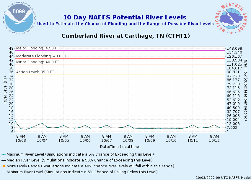
Potential River Levels Used to Estimate the Chance of Flooding and the Range of Possible River Levels |
||
| 10 Day (HEFS) | 7 Day (NAEFS) | 7 Day (GEFS) |
 |
 |
 |
Note: Use the official hydrograph at the top of this web page for river levels within the next 72 hours.
Click individual graphics to enlarge.
Collaborative Agencies
The National Weather Service prepares its forecasts and other services in collaboration with agencies like the US Geological Survey, US Bureau of Reclamation, US Army Corps of Engineers, Natural Resource Conservation Service, National Park Service, ALERT Users Group, Bureau of Indian Affairs, and many state and local emergency managers across the country. For details, please click here.