Washita River near Dickson
Future / Actual / Minor
OWP 2.0 WWA Modal Title
01/11/2021, 10:04 PM UTC through 01/11/2021, 10:04 PM UTC
Sender
Sent
- Warning: no valid ratings curve available. Transformations to and from FEET/CFS/KCFS will not happen.
Traces and Thresholds Click to turn on/off display
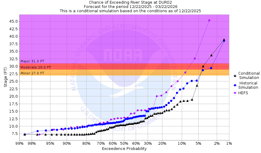
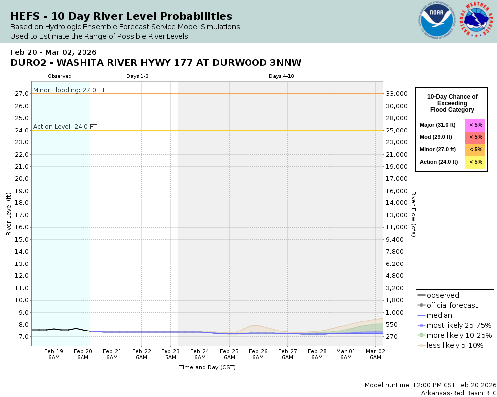
CATEGORY STAGE Major Flooding 31 ft Moderate Flooding 29 ft Minor Flooding 27 ft Action 24 ft Reliability of the Forecast:
NOTE: Forecasts are issued routinely year-round.
River forecasts for this location take into account past precipitation and the precipitation amounts expected approximately 24 hours into the future from the forecast issuance time.
National Water Model Hydrograph
Official NWS streamflow forecasts are produced by NWS hydrologic forecasters for river gauge locations using hydrologic models which are calibrated to that location. This process considers additional guidance and information, including local expertise and experience, to produce the best forecast possible. The NWM output provides supplemental guidance to NWS forecasters and should not be considered an official NWS river forecast.
Flood Impacts
- 50 - Dangerous flood depths of 25 feet or more inundate areas along the Washita River... from Murray County... to near Dickson in Carter County... to the headwaters of Lake Texoma. Over 10 thousand acres of agricultural lands are covered. Flood levels are over 1 foot higher than the flood crest of June 19...2015.
- 49 - Dangerous flood depths of 24 feet or more inundate areas along the Washita River... from Murray County... to near Dickson in Carter County... to the headwaters of Lake Texoma. Over 10 thousand acres of agricultural lands are covered. Flood levels are slightly higher than the flood crest of June 19...2015.
- 48 - Dangerous flood depths of 23 feet or more inundate areas along the Washita River... from Murray County... to near Dickson in Carter County... to the headwaters of Lake Texoma. Over 10 thousand acres of agricultural lands are covered. Flood levels are nearly 3 feet higher than the flood crest of May 30...1987.
Gauge Location
Recent Crests
| 1. | 33.96 ft | on 05-02-2025 | (P) |
| 2. | 16.33 ft | on 06-10-2022 | (P) |
| 3. | 30.93 ft | on 04-29-2021 | |
| 4. | 24.43 ft | on 09-02-2020 | |
| 5. | 27.04 ft | on 03-20-2020 |
Recent Crests
| 1. | 33.96 ft | on 05-02-2025 | (P) |
| 2. | 16.33 ft | on 06-10-2022 | (P) |
| 3. | 30.93 ft | on 04-29-2021 | |
| 4. | 24.43 ft | on 09-02-2020 | |
| 5. | 27.04 ft | on 03-20-2020 | |
| 6. | 26.02 ft | on 05-02-2019 | |
| 7. | 24.18 ft | on 09-22-2018 | |
| 8. | 28.52 ft | on 05-21-2017 | |
| 9. | 29.96 ft | on 06-13-2016 | |
| 10. | 30.41 ft | on 04-19-2016 | |
| 11. | 26.96 ft | on 12-28-2015 | |
| 12. | 32.82 ft | on 07-08-2015 | |
| 13. | 25.10 ft | on 07-04-2015 | |
| 14. | 48.70 ft | on 06-19-2015 | |
| 15. | 35.85 ft | on 05-29-2015 | |
| 16. | 34.60 ft | on 05-26-2015 | |
| 17. | 24.45 ft | on 05-18-2015 | |
| 18. | 32.68 ft | on 05-11-2015 | |
| 19. | 26.14 ft | on 05-07-2009 | |
| 20. | 24.97 ft | on 04-30-2009 | |
| 21. | 24.28 ft | on 04-11-2008 | |
| 22. | 28.51 ft | on 07-01-2007 | |
| 23. | 29.30 ft | on 05-28-2007 | |
| 24. | 24.82 ft | on 04-08-2002 | |
| 25. | 25.53 ft | on 02-16-2001 | |
| 26. | 24.58 ft | on 04-27-1999 | |
| 27. | 27.99 ft | on 03-17-1998 | |
| 28. | 25.86 ft | on 02-21-1997 | |
| 29. | 30.92 ft | on 06-11-1995 | |
| 30. | 30.03 ft | on 05-08-1995 | |
| 31. | 31.64 ft | on 05-10-1993 | |
| 32. | 28.45 ft | on 12-21-1991 | |
| 33. | 44.26 ft | on 05-03-1990 | |
| 34. | 39.10 ft | on 04-26-1990 | |
| 35. | 32.80 ft | on 04-21-1990 | |
| 36. | 28.90 ft | on 03-15-1990 | |
| 37. | 27.00 ft | on 03-12-1990 | |
| 38. | 26.23 ft | on 04-02-1988 | |
| 39. | 45.24 ft | on 05-30-1987 | |
| 40. | 28.93 ft | on 06-06-1985 | |
| 41. | 27.73 ft | on 01-01-1985 | |
| 42. | 27.04 ft | on 05-15-1983 | |
| 43. | 31.53 ft | on 05-29-1982 | |
| 44. | 26.74 ft | on 10-13-1981 | |
| 45. | 29.40 ft | on 05-31-1980 | |
| 46. | 28.31 ft | on 06-10-1979 | |
| 47. | 26.28 ft | on 05-29-1978 | |
| 48. | 29.41 ft | on 05-21-1977 | |
| 49. | 28.23 ft | on 11-01-1974 | |
| 50. | 26.24 ft | on 05-01-1974 | |
| 51. | 31.85 ft | on 11-26-1973 | |
| 52. | 29.89 ft | on 04-21-1973 | |
| 53. | 33.14 ft | on 10-09-1970 | |
| 54. | 28.36 ft | on 06-02-1968 | |
| 55. | 27.28 ft | on 04-12-1967 | |
| 56. | 27.32 ft | on 05-26-1957 | |
| 57. | 42.30 ft | on 05-19-1957 | |
| 58. | 26.11 ft | on 04-26-1957 | |
| 59. | 26.08 ft | on 04-24-1957 | |
| 60. | 26.28 ft | on 05-13-1954 | |
| 61. | 26.26 ft | on 10-24-1953 | |
| 62. | 27.08 ft | on 06-12-1951 | |
| 63. | 42.57 ft | on 05-12-1950 | |
| 64. | 26.18 ft | on 06-13-1949 | |
| 65. | 29.01 ft | on 06-24-1947 | |
| 66. | 35.22 ft | on 05-25-1947 | |
| 67. | 32.23 ft | on 05-21-1947 | |
| 68. | 26.85 ft | on 05-17-1947 | |
| 69. | 31.22 ft | on 04-16-1947 | |
| 70. | 34.12 ft | on 12-12-1946 | |
| 71. | 29.74 ft | on 06-01-1946 | |
| 72. | 26.54 ft | on 02-19-1946 | |
| 73. | 33.30 ft | on 01-05-1946 | |
| 74. | 41.54 ft | on 10-01-1945 | |
| 75. | 31.34 ft | on 09-28-1945 | |
| 76. | 31.65 ft | on 07-11-1945 | |
| 77. | 31.37 ft | on 06-18-1945 | |
| 78. | 33.58 ft | on 06-13-1945 | |
| 79. | 32.19 ft | on 06-10-1945 | |
| 80. | 31.63 ft | on 04-24-1945 | |
| 81. | 34.38 ft | on 03-20-1945 | |
| 82. | 38.51 ft | on 03-16-1945 | |
| 83. | 44.35 ft | on 05-11-1943 | |
| 84. | 26.18 ft | on 04-12-1943 | |
| 85. | 26.23 ft | on 11-08-1942 | |
| 86. | 30.38 ft | on 06-23-1942 | |
| 87. | 34.68 ft | on 04-25-1942 | |
| 88. | 35.41 ft | on 04-21-1942 | |
| 89. | 38.25 ft | on 04-09-1942 | |
| 90. | 44.37 ft | on 10-31-1941 | |
| 91. | 38.27 ft | on 10-06-1941 | |
| 92. | 31.56 ft | on 06-13-1941 | |
| 93. | 28.21 ft | on 05-25-1938 | |
| 94. | 30.95 ft | on 03-30-1938 | |
| 95. | 41.20 ft | on 02-17-1938 | |
| 96. | 27.02 ft | on 09-28-1936 | |
| 97. | 31.97 ft | on 05-09-1936 | |
| 98. | 37.22 ft | on 05-19-1935 | |
| 99. | 28.89 ft | on 05-06-1935 | |
| 100. | 33.92 ft | on 05-25-1933 | |
| 101. | 32.03 ft | on 05-16-1933 | |
| 102. | 26.53 ft | on 12-24-1932 | |
| 103. | 26.53 ft | on 07-07-1932 | |
| 104. | 27.58 ft | on 01-06-1932 | |
| 105. | 28.20 ft | on 11-24-1931 | |
| 106. | 27.94 ft | on 05-16-1930 | |
| 107. | 26.30 ft | on 06-01-1929 | |
| 108. | 26.24 ft | on 05-12-1929 | |
| 109. | 38.00 ft | on 04-16-1927 | |
| 110. | 42.00 ft | on 05-24-1908 |
Historic Crests
| 1. | 48.70 ft | on 06-19-2015 |
| 2. | 45.24 ft | on 05-30-1987 |
| 3. | 44.37 ft | on 10-31-1941 |
| 4. | 44.35 ft | on 05-11-1943 |
| 5. | 44.26 ft | on 05-03-1990 |
Historic Crests
| 1. | 48.70 ft | on 06-19-2015 | |
| 2. | 45.24 ft | on 05-30-1987 | |
| 3. | 44.37 ft | on 10-31-1941 | |
| 4. | 44.35 ft | on 05-11-1943 | |
| 5. | 44.26 ft | on 05-03-1990 | |
| 6. | 42.57 ft | on 05-12-1950 | |
| 7. | 42.30 ft | on 05-19-1957 | |
| 8. | 42.00 ft | on 05-24-1908 | |
| 9. | 41.54 ft | on 10-01-1945 | |
| 10. | 41.20 ft | on 02-17-1938 | |
| 11. | 39.10 ft | on 04-26-1990 | |
| 12. | 38.51 ft | on 03-16-1945 | |
| 13. | 38.27 ft | on 10-06-1941 | |
| 14. | 38.25 ft | on 04-09-1942 | |
| 15. | 38.00 ft | on 04-16-1927 | |
| 16. | 37.22 ft | on 05-19-1935 | |
| 17. | 35.85 ft | on 05-29-2015 | |
| 18. | 35.41 ft | on 04-21-1942 | |
| 19. | 35.22 ft | on 05-25-1947 | |
| 20. | 34.68 ft | on 04-25-1942 | |
| 21. | 34.60 ft | on 05-26-2015 | |
| 22. | 34.38 ft | on 03-20-1945 | |
| 23. | 34.12 ft | on 12-12-1946 | |
| 24. | 33.96 ft | on 05-02-2025 | (P) |
| 25. | 33.92 ft | on 05-25-1933 | |
| 26. | 33.58 ft | on 06-13-1945 | |
| 27. | 33.30 ft | on 01-05-1946 | |
| 28. | 33.14 ft | on 10-09-1970 | |
| 29. | 32.82 ft | on 07-08-2015 | |
| 30. | 32.80 ft | on 04-21-1990 | |
| 31. | 32.68 ft | on 05-11-2015 | |
| 32. | 32.23 ft | on 05-21-1947 | |
| 33. | 32.19 ft | on 06-10-1945 | |
| 34. | 32.03 ft | on 05-16-1933 | |
| 35. | 31.97 ft | on 05-09-1936 | |
| 36. | 31.85 ft | on 11-26-1973 | |
| 37. | 31.65 ft | on 07-11-1945 | |
| 38. | 31.64 ft | on 05-10-1993 | |
| 39. | 31.63 ft | on 04-24-1945 | |
| 40. | 31.56 ft | on 06-13-1941 | |
| 41. | 31.53 ft | on 05-29-1982 | |
| 42. | 31.37 ft | on 06-18-1945 | |
| 43. | 31.34 ft | on 09-28-1945 | |
| 44. | 31.22 ft | on 04-16-1947 | |
| 45. | 30.95 ft | on 03-30-1938 | |
| 46. | 30.93 ft | on 04-29-2021 | |
| 47. | 30.92 ft | on 06-11-1995 | |
| 48. | 30.41 ft | on 04-19-2016 | |
| 49. | 30.38 ft | on 06-23-1942 | |
| 50. | 30.03 ft | on 05-08-1995 | |
| 51. | 29.96 ft | on 06-13-2016 | |
| 52. | 29.89 ft | on 04-21-1973 | |
| 53. | 29.74 ft | on 06-01-1946 | |
| 54. | 29.41 ft | on 05-21-1977 | |
| 55. | 29.40 ft | on 05-31-1980 | |
| 56. | 29.30 ft | on 05-28-2007 | |
| 57. | 29.01 ft | on 06-24-1947 | |
| 58. | 28.93 ft | on 06-06-1985 | |
| 59. | 28.90 ft | on 03-15-1990 | |
| 60. | 28.89 ft | on 05-06-1935 | |
| 61. | 28.52 ft | on 05-21-2017 | |
| 62. | 28.51 ft | on 07-01-2007 | |
| 63. | 28.45 ft | on 12-21-1991 | |
| 64. | 28.36 ft | on 06-02-1968 | |
| 65. | 28.31 ft | on 06-10-1979 | |
| 66. | 28.23 ft | on 11-01-1974 | |
| 67. | 28.21 ft | on 05-25-1938 | |
| 68. | 28.20 ft | on 11-24-1931 | |
| 69. | 27.99 ft | on 03-17-1998 | |
| 70. | 27.94 ft | on 05-16-1930 | |
| 71. | 27.73 ft | on 01-01-1985 | |
| 72. | 27.58 ft | on 01-06-1932 | |
| 73. | 27.32 ft | on 05-26-1957 | |
| 74. | 27.28 ft | on 04-12-1967 | |
| 75. | 27.08 ft | on 06-12-1951 | |
| 76. | 27.04 ft | on 05-15-1983 | |
| 77. | 27.04 ft | on 03-20-2020 | |
| 78. | 27.02 ft | on 09-28-1936 | |
| 79. | 27.00 ft | on 03-12-1990 | |
| 80. | 26.96 ft | on 12-28-2015 | |
| 81. | 26.85 ft | on 05-17-1947 | |
| 82. | 26.74 ft | on 10-13-1981 | |
| 83. | 26.54 ft | on 02-19-1946 | |
| 84. | 26.53 ft | on 12-24-1932 | |
| 85. | 26.53 ft | on 07-07-1932 | |
| 86. | 26.30 ft | on 06-01-1929 | |
| 87. | 26.28 ft | on 05-29-1978 | |
| 88. | 26.28 ft | on 05-13-1954 | |
| 89. | 26.26 ft | on 10-24-1953 | |
| 90. | 26.24 ft | on 05-01-1974 | |
| 91. | 26.24 ft | on 05-12-1929 | |
| 92. | 26.23 ft | on 04-02-1988 | |
| 93. | 26.23 ft | on 11-08-1942 | |
| 94. | 26.18 ft | on 04-12-1943 | |
| 95. | 26.18 ft | on 06-13-1949 | |
| 96. | 26.14 ft | on 05-07-2009 | |
| 97. | 26.11 ft | on 04-26-1957 | |
| 98. | 26.08 ft | on 04-24-1957 | |
| 99. | 26.02 ft | on 05-02-2019 | |
| 100. | 25.86 ft | on 02-21-1997 | |
| 101. | 25.53 ft | on 02-16-2001 | |
| 102. | 25.10 ft | on 07-04-2015 | |
| 103. | 24.97 ft | on 04-30-2009 | |
| 104. | 24.82 ft | on 04-08-2002 | |
| 105. | 24.58 ft | on 04-27-1999 | |
| 106. | 24.45 ft | on 05-18-2015 | |
| 107. | 24.43 ft | on 09-02-2020 | |
| 108. | 24.28 ft | on 04-11-2008 | |
| 109. | 24.18 ft | on 09-22-2018 | |
| 110. | 16.33 ft | on 06-10-2022 | (P) |
Vertical Datum Table
| type | NAVD88 |
|---|---|
| major Flooding | 681.45 ft |
| moderate Flooding | 679.45 ft |
| minor Flooding | 677.45 ft |
| action | 674.45 ft |
| Latest Value | 657.90 ft |
| Gauge Zero | 650.45 ft |
Gauge Photos
No Images Found


Collaborative Agencies
The National Weather Service prepares its forecasts and other services in collaboration with agencies like the US Geological Survey, US Bureau of Reclamation, US Army Corps of Engineers, Natural Resource Conservation Service, National Park Service, ALERT Users Group, Bureau of Indian Affairs, and many state and local emergency managers across the country. For details, please click here.