Ohio River at Wellsville
Future / Actual / Minor
OWP 2.0 WWA Modal Title
01/11/2021, 10:04 PM UTC through 01/11/2021, 10:04 PM UTC
Sender
Sent
- Warning: no valid ratings curve available. Transformations to and from FEET/CFS/KCFS will not happen.No secondary data available. Transformations for Flow data and a secondary Y axis cannot be made at this time.
National Water Model Hydrograph
Official NWS streamflow forecasts are produced by NWS hydrologic forecasters for river gauge locations using hydrologic models which are calibrated to that location. This process considers additional guidance and information, including local expertise and experience, to produce the best forecast possible. The NWM output provides supplemental guidance to NWS forecasters and should not be considered an official NWS river forecast.
Flood Impacts
- 31 - Water overtops the Corp of Engineers flood wall and water begins to flow into the town of Wellsville.
- 20.2 - Flood waters reach the levels of flooding from Hurricane Ivan of September 19, 2004.
- 18 - Water reaches the restaurant near the north end of the Lisbon Street Bridge.
Gauge Info
| Coordinates | 40.6142, -80.6411 |
| RFC | OHRFC |
| State | OH |
| WFO | PBZ |
| County | Columbiana |
| Data Provider(s) | |
| US Geological Survey | USGS--Water Resources of the United States |
Gauge Location
Recent Crests
| 1. | 10.40 ft | on 04-13-2024 | |
| 2. | 14.00 ft | on 04-04-2024 | (P) |
| 3. | 16.70 ft | on 01-06-2005 | |
| 4. | 20.20 ft | on 09-18-2004 | |
| 5. | 20.90 ft | on 01-20-1996 |
Recent Crests
| 1. | 10.40 ft | on 04-13-2024 | |
| 2. | 14.00 ft | on 04-04-2024 | (P) |
| 3. | 16.70 ft | on 01-06-2005 | |
| 4. | 20.20 ft | on 09-18-2004 | |
| 5. | 20.90 ft | on 01-20-1996 |
Historic Crests
| 1. | 20.90 ft | on 01-20-1996 | |
| 2. | 20.20 ft | on 09-18-2004 | |
| 3. | 16.70 ft | on 01-06-2005 | |
| 4. | 14.00 ft | on 04-04-2024 | (P) |
| 5. | 10.40 ft | on 04-13-2024 |
Historic Crests
| 1. | 20.90 ft | on 01-20-1996 | |
| 2. | 20.20 ft | on 09-18-2004 | |
| 3. | 16.70 ft | on 01-06-2005 | |
| 4. | 14.00 ft | on 04-04-2024 | (P) |
| 5. | 10.40 ft | on 04-13-2024 |
Vertical Datum Table
| type | NGVD29 |
|---|---|
| major Flooding | 677.00 ft |
| moderate Flooding | 675.00 ft |
| minor Flooding | 672.00 ft |
| action | 670.00 ft |
| Latest Value | N/A |
| Gauge Zero | 661.00 ft |
Gauge Photos
No Images Found


Unique Local Info
|
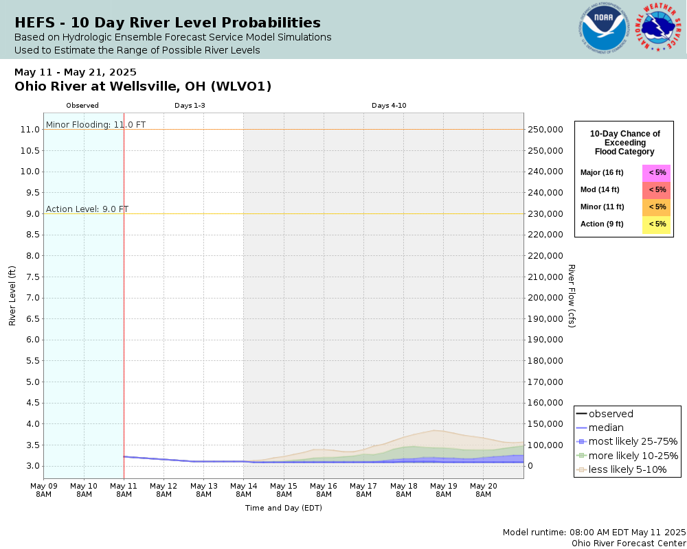
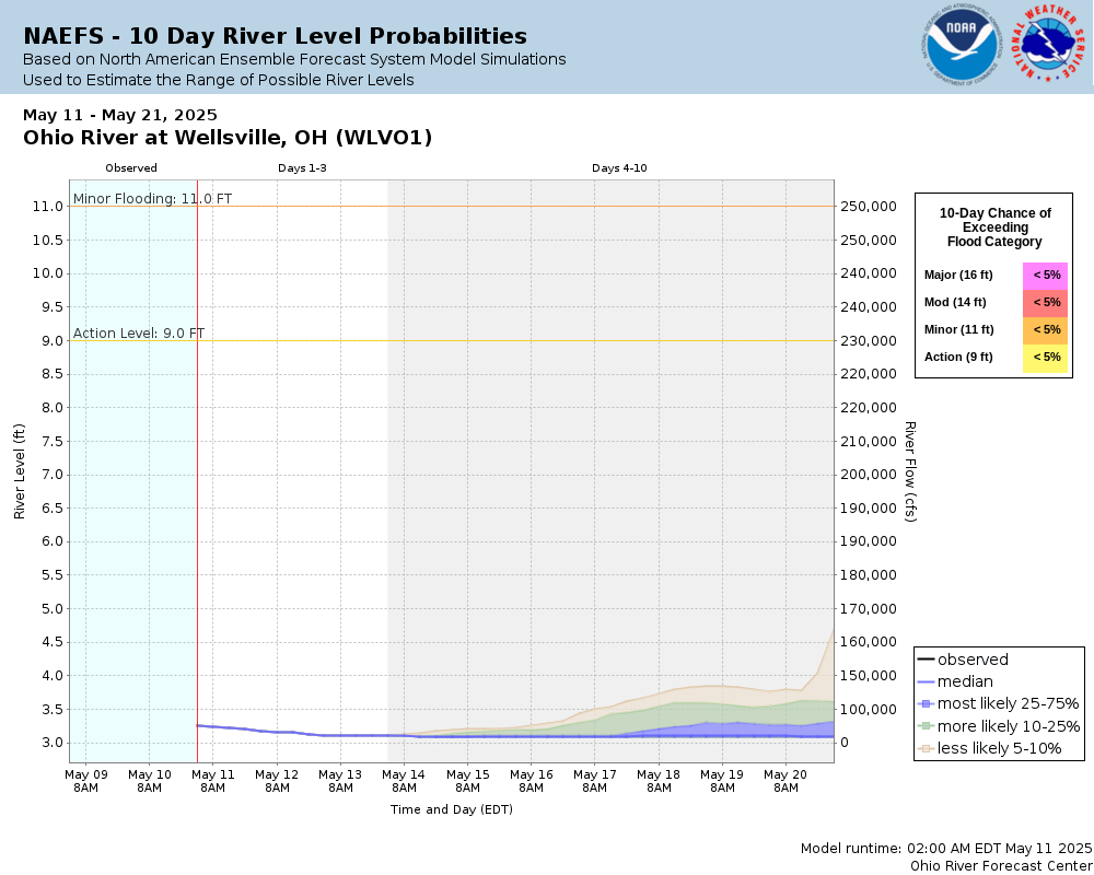
Potential River Levels Used to Estimate the Chance of Flooding and the Range of Possible River Levels |
||
| 10 Day (HEFS) | 10 Day (NAEFS) | 10 Day (GEFS) |
 |
 |
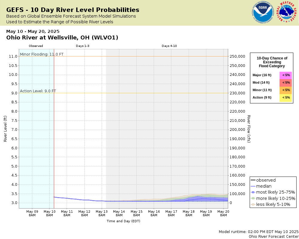 |
Note: Use the official hydrograph at the top of this web page for river levels within the next 72 hours.
Collaborative Agencies
The National Weather Service prepares its forecasts and other services in collaboration with agencies like the US Geological Survey, US Bureau of Reclamation, US Army Corps of Engineers, Natural Resource Conservation Service, National Park Service, ALERT Users Group, Bureau of Indian Affairs, and many state and local emergency managers across the country. For details, please click here.