Skip Navigation Link weather.gov  
NOAA logo - Click to go to the NOAA homepage National Weather Service NWS logo - Click to go to the NWS homepage
Advanced Hydrologic Prediction Service
Image background of Navigation bar Left
Bookmark and Share Navigation Bar End Cap


Web Portal Changes: The Advanced Hydrologic Prediction Service (AHPS) hosted at https://water.weather.gov will be replaced by the National Water Prediction Service (NWPS), with a target of March 2024. Existing AHPS content and features will be preserved and expanded within NWPS.

Experimental National Water Center Products: Flood Inundation Mapping services are now available for 10% of the U.S. population. Please visit https://www.weather.gov/owp/operations for more information. The National Hydrologic Discussion, Area Hydrologic Discussion, Flood Hazard Outlook, and real-time geospatial services depicting River Forecast Center and National Water Model forecasts, continue to be accessible via the URL above, as described in the StoryMap here.


Hydrograph River at a Glance Download Inundation
Mapping
Neuse River near Goldsboro Stage (ft)Flow (kcfs)Highest Observation: 4.03 ft at 6:30PM Oct 01, 2023Highest Observation: 4.03 ft at 6:45PM Oct 01, 2023Observed: 4.02 ft at 7:00PM Oct 01, 2023Observed: 4.02 ft at 7:01PM Oct 01, 2023Observed: 4.02 ft at 7:15PM Oct 01, 2023Observed: 4.02 ft at 7:16PM Oct 01, 2023Observed: 4.02 ft at 7:30PM Oct 01, 2023Observed: 4.02 ft at 7:31PM Oct 01, 2023Observed: 4.02 ft at 7:45PM Oct 01, 2023Observed: 4.02 ft at 7:46PM Oct 01, 2023Observed: 4.01 ft at 8:00PM Oct 01, 2023Observed: 4.01 ft at 8:15PM Oct 01, 2023Observed: 4 ft at 8:30PM Oct 01, 2023Observed: 4 ft at 8:45PM Oct 01, 2023Observed: 4 ft at 9:00PM Oct 01, 2023Observed: 3.99 ft at 9:15PM Oct 01, 2023Observed: 3.99 ft at 9:30PM Oct 01, 2023Observed: 3.99 ft at 9:45PM Oct 01, 2023Observed: 3.98 ft at 10:00PM Oct 01, 2023Observed: 3.98 ft at 10:15PM Oct 01, 2023Observed: 3.98 ft at 10:30PM Oct 01, 2023Observed: 3.97 ft at 10:45PM Oct 01, 2023Observed: 3.97 ft at 11:00PM Oct 01, 2023Observed: 3.96 ft at 11:15PM Oct 01, 2023Observed: 3.96 ft at 11:30PM Oct 01, 2023Observed: 3.96 ft at 11:45PM Oct 01, 2023Observed: 3.96 ft at 12:00AM Oct 02, 2023Observed: 3.96 ft at 12:15AM Oct 02, 2023Observed: 3.95 ft at 12:30AM Oct 02, 2023Observed: 3.95 ft at 12:45AM Oct 02, 2023Observed: 3.95 ft at 1:00AM Oct 02, 2023Observed: 3.95 ft at 1:15AM Oct 02, 2023Observed: 3.95 ft at 1:30AM Oct 02, 2023Observed: 3.95 ft at 1:45AM Oct 02, 2023Observed: 3.94 ft at 2:00AM Oct 02, 2023Observed: 3.94 ft at 2:15AM Oct 02, 2023Observed: 3.94 ft at 2:30AM Oct 02, 2023Observed: 3.94 ft at 2:45AM Oct 02, 2023Observed: 3.94 ft at 3:00AM Oct 02, 2023Observed: 3.94 ft at 3:15AM Oct 02, 2023Observed: 3.93 ft at 3:30AM Oct 02, 2023Observed: 3.93 ft at 3:45AM Oct 02, 2023Observed: 3.93 ft at 4:00AM Oct 02, 2023Observed: 3.92 ft at 4:15AM Oct 02, 2023Observed: 3.92 ft at 4:30AM Oct 02, 2023Observed: 3.92 ft at 4:45AM Oct 02, 2023Observed: 3.92 ft at 5:00AM Oct 02, 2023Observed: 3.92 ft at 5:15AM Oct 02, 2023Observed: 3.91 ft at 5:30AM Oct 02, 2023Observed: 3.91 ft at 5:45AM Oct 02, 2023Observed: 3.91 ft at 6:00AM Oct 02, 2023Observed: 3.91 ft at 6:15AM Oct 02, 2023Observed: 3.9 ft at 6:30AM Oct 02, 2023Observed: 3.9 ft at 6:45AM Oct 02, 2023Observed: 3.9 ft at 7:00AM Oct 02, 2023Observed: 3.89 ft at 7:15AM Oct 02, 2023Observed: 3.89 ft at 7:30AM Oct 02, 2023Observed: 3.89 ft at 7:45AM Oct 02, 2023Observed: 3.88 ft at 8:00AM Oct 02, 2023Observed: 3.88 ft at 8:15AM Oct 02, 2023Observed: 3.88 ft at 8:30AM Oct 02, 2023Observed: 3.87 ft at 8:45AM Oct 02, 2023Observed: 3.87 ft at 9:00AM Oct 02, 2023Observed: 3.86 ft at 9:15AM Oct 02, 2023Observed: 3.86 ft at 9:30AM Oct 02, 2023Observed: 3.86 ft at 9:45AM Oct 02, 2023Observed: 3.85 ft at 10:00AM Oct 02, 2023Observed: 3.85 ft at 10:15AM Oct 02, 2023Observed: 3.84 ft at 10:30AM Oct 02, 2023Observed: 3.84 ft at 10:45AM Oct 02, 2023Observed: 3.84 ft at 11:00AM Oct 02, 2023Observed: 3.83 ft at 11:15AM Oct 02, 2023Observed: 3.83 ft at 11:30AM Oct 02, 2023Observed: 3.82 ft at 11:45AM Oct 02, 2023Observed: 3.82 ft at 12:00PM Oct 02, 2023Observed: 3.82 ft at 12:15PM Oct 02, 2023Observed: 3.81 ft at 12:30PM Oct 02, 2023Observed: 3.8 ft at 12:45PM Oct 02, 2023Observed: 3.8 ft at 1:00PM Oct 02, 2023Observed: 3.8 ft at 1:15PM Oct 02, 2023Observed: 3.8 ft at 1:30PM Oct 02, 2023Observed: 3.79 ft at 1:45PM Oct 02, 2023Observed: 3.79 ft at 2:00PM Oct 02, 2023Observed: 3.79 ft at 2:15PM Oct 02, 2023Observed: 3.78 ft at 2:30PM Oct 02, 2023Observed: 3.78 ft at 2:45PM Oct 02, 2023Observed: 3.78 ft at 3:00PM Oct 02, 2023Observed: 3.78 ft at 3:15PM Oct 02, 2023Observed: 3.78 ft at 3:30PM Oct 02, 2023Observed: 3.77 ft at 3:45PM Oct 02, 2023Observed: 3.77 ft at 4:00PM Oct 02, 2023Observed: 3.76 ft at 4:15PM Oct 02, 2023Observed: 3.76 ft at 4:30PM Oct 02, 2023Observed: 3.76 ft at 4:45PM Oct 02, 2023Observed: 3.76 ft at 5:00PM Oct 02, 2023Observed: 3.75 ft at 5:15PM Oct 02, 2023Observed: 3.75 ft at 5:30PM Oct 02, 2023Observed: 3.75 ft at 5:45PM Oct 02, 2023Observed: 3.74 ft at 6:00PM Oct 02, 2023Observed: 3.74 ft at 6:15PM Oct 02, 2023Observed: 3.74 ft at 6:30PM Oct 02, 2023Observed: 3.74 ft at 6:45PM Oct 02, 2023Observed: 3.74 ft at 7:00PM Oct 02, 2023Observed: 3.74 ft at 7:01PM Oct 02, 2023Observed: 3.73 ft at 7:15PM Oct 02, 2023Observed: 3.73 ft at 7:16PM Oct 02, 2023Observed: 3.73 ft at 7:30PM Oct 02, 2023Observed: 3.73 ft at 7:31PM Oct 02, 2023Observed: 3.73 ft at 7:45PM Oct 02, 2023Observed: 3.73 ft at 7:46PM Oct 02, 2023Observed: 3.73 ft at 8:00PM Oct 02, 2023Observed: 3.72 ft at 8:15PM Oct 02, 2023Observed: 3.72 ft at 8:30PM Oct 02, 2023Observed: 3.72 ft at 8:45PM Oct 02, 2023Observed: 3.72 ft at 9:00PM Oct 02, 2023Observed: 3.72 ft at 9:15PM Oct 02, 2023Observed: 3.72 ft at 9:30PM Oct 02, 2023Observed: 3.71 ft at 9:45PM Oct 02, 2023Observed: 3.71 ft at 10:00PM Oct 02, 2023Observed: 3.71 ft at 10:15PM Oct 02, 2023Observed: 3.71 ft at 10:30PM Oct 02, 2023Observed: 3.71 ft at 10:45PM Oct 02, 2023Observed: 3.71 ft at 11:00PM Oct 02, 2023Observed: 3.7 ft at 11:15PM Oct 02, 2023Observed: 3.7 ft at 11:30PM Oct 02, 2023Observed: 3.7 ft at 11:45PM Oct 02, 2023Observed: 3.7 ft at 12:00AM Oct 03, 2023Observed: 3.7 ft at 12:15AM Oct 03, 2023Observed: 3.69 ft at 12:30AM Oct 03, 2023Observed: 3.69 ft at 12:45AM Oct 03, 2023Observed: 3.69 ft at 1:00AM Oct 03, 2023Observed: 3.69 ft at 1:15AM Oct 03, 2023Observed: 3.68 ft at 1:30AM Oct 03, 2023Observed: 3.68 ft at 1:45AM Oct 03, 2023Observed: 3.68 ft at 2:00AM Oct 03, 2023Observed: 3.68 ft at 2:15AM Oct 03, 2023Observed: 3.68 ft at 2:30AM Oct 03, 2023Observed: 3.68 ft at 2:45AM Oct 03, 2023Observed: 3.68 ft at 3:00AM Oct 03, 2023Observed: 3.68 ft at 3:15AM Oct 03, 2023Observed: 3.68 ft at 3:30AM Oct 03, 2023Observed: 3.68 ft at 3:45AM Oct 03, 2023Observed: 3.68 ft at 4:00AM Oct 03, 2023Observed: 3.68 ft at 4:15AM Oct 03, 2023Observed: 3.68 ft at 4:30AM Oct 03, 2023Observed: 3.67 ft at 4:45AM Oct 03, 2023Observed: 3.67 ft at 5:00AM Oct 03, 2023Observed: 3.67 ft at 5:15AM Oct 03, 2023Observed: 3.67 ft at 5:30AM Oct 03, 2023Observed: 3.67 ft at 5:45AM Oct 03, 2023Observed: 3.67 ft at 6:00AM Oct 03, 2023Observed: 3.66 ft at 6:15AM Oct 03, 2023Observed: 3.66 ft at 6:30AM Oct 03, 2023Observed: 3.66 ft at 6:45AM Oct 03, 2023Observed: 3.66 ft at 7:00AM Oct 03, 2023Observed: 3.66 ft at 7:15AM Oct 03, 2023Observed: 3.65 ft at 7:30AM Oct 03, 2023Observed: 3.65 ft at 7:45AM Oct 03, 2023Observed: 3.65 ft at 8:00AM Oct 03, 2023Observed: 3.65 ft at 8:15AM Oct 03, 2023Observed: 3.64 ft at 8:30AM Oct 03, 2023Observed: 3.64 ft at 8:45AM Oct 03, 2023Observed: 3.64 ft at 9:00AM Oct 03, 2023Observed: 3.64 ft at 9:15AM Oct 03, 2023Highest Forecast: 3.6 ft 2:00PM Oct 03, 2023Highest Forecast: 3.6 ft 8:00PM Oct 03, 2023Highest Forecast: 3.6 ft 2:00AM Oct 04, 2023Forecast: 3.5 ft 8:00AM Oct 04, 2023Forecast: 3.5 ft 2:00PM Oct 04, 2023Forecast: 3.5 ft 8:00PM Oct 04, 2023Forecast: 3.5 ft 2:00AM Oct 05, 2023Forecast: 3.4 ft 8:00AM Oct 05, 2023Forecast: 3.4 ft 2:00PM Oct 05, 2023Forecast: 3.4 ft 8:00PM Oct 05, 2023Forecast: 3.4 ft 2:00AM Oct 06, 2023Forecast: 3.4 ft 8:00AM Oct 06, 2023Forecast: 3.4 ft 2:00PM Oct 06, 2023Forecast: 3.4 ft 8:00PM Oct 06, 2023Forecast: 3.4 ft 2:00AM Oct 07, 2023Forecast: 3.3 ft 8:00AM Oct 07, 2023Forecast: 3.3 ft 2:00PM Oct 07, 2023Forecast: 3.3 ft 8:00PM Oct 07, 2023Forecast: 3.3 ft 2:00AM Oct 08, 2023Forecast: 3.3 ft 8:00AM Oct 08, 2023USGS--Water Resources of the United StatesGLDN7(plotting HGIRG) Graph Created (9:49AM Oct 3, 2023)ObservedForecast (issued 8:47AM Oct 3)Latest observed value: 3.64 ft at 9:15 AM EDT 3-Oct-2023. Flood Stage is 18 ft
Printable Image
About this graph
Tabular Data (UTC)
Tabular Data (EDT)
XML Data
RSS Files
Datum: NAVD88
Metadata
NOTE: Forecasts for the Neuse River near Goldsboro are issued routinely year-round.
Return to Area Map
Upstream Gauge - at Smithfield Upstream Gauge Downstream Gauge Downstream Gauge - at Kinston
Flood Categories (in feet)
Major Flood Stage: 24
Moderate Flood Stage: 20
Flood Stage: 18
Action Stage: 17
Low Stage (in feet): 0

Historic Crests
(1) 29.74 ft on 10/12/2016
(2) 28.85 ft on 09/20/1999
(3) 27.60 ft on 09/19/2018
(4) 27.30 ft on 10/05/1929
(5) 26.70 ft on 09/23/1945
Show More Historic Crests

(P): Preliminary values subject to further review.

Recent Crests
(1) 21.96 ft on 02/20/2021 (P)
(2) 21.49 ft on 01/07/2021 (P)
(3) 18.40 ft on 12/30/2020 (P)
(4) 18.00 ft on 12/28/2020 (P)
(5) 22.39 ft on 02/12/2020
Show More Recent Crests

(P): Preliminary values subject to further review.

Low Water Records
(1) 2.10 ft on 09/03/1980
(2) 2.22 ft on 10/25/1981
(3) 2.25 ft on 10/03/1985
(4) 2.40 ft on 11/12/1986
(5) 2.46 ft on 10/20/1983
Show More Low Water Records

For more information on your flood risk go to www.floodsmart.gov.

Zoom Level:16
KML Image
Gauge LocationGauge Map Marker
Disclaimer
Latitude/Longitude Disclaimer: The gauge location shown in the above map is the approximate location based on the latitude/longitude coordinates provided to the NWS by the gauge owner.
Flood Impacts & Photos Collapse
If you notice any errors in the below information, please contact our Webmaster
31 Flooding reaches the base of the Arrington Bridge Rd bridge.
29 The Little River backs up and US70 and NC55 are closed. The water treatment plant is flooded.
28 The northbound lane of Arrington Bridge Rd is impassable, which cuts off access to medical facilities for residents south of the city. Emergency services must set up a temporary triage.
26 Flooding threatens to close US117.
24 Major flooding begins. Strobe lights at the end of the runway at Seymour Johnson Air Force base are flooded.
23 Strobe lights at the end of the runway at Seymour Johnson Air Force base are flooded.
22.5 Evacuation of some homes in the Mar-Mac area and possibly the Buckhorn Island subdivision may be necessary.
22 Flooding begins on Seymour Johnson Air Force Base.
21 Riverview Trailer Park homes and Stevens Mill Road begin to flood.
20 Moderate flooding begins. Arrington Bridge Road and access roads around Seymour Johnson Air Force Base flood.
18 Minor flooding bagins. Water overflows the banks at the Arrington Bridge Rd and upstream of the US 117 bridge. Ferry Bridge Rd begins to flood.
Photos
(1) Arrington Bridge Road
(2) Downstream - High Flow
(3) Upstream - High Flow
About This Location Collapse

Latitude: 35.337500° N, Longitude: 77.997500° W, Horizontal Datum: NAD83/WGS84

River Stage
Reference Frame
Gauge Height Flood Stage Uses
NWS stage 0 ft 18 ft Interpreting hydrographs and NWS watch, warnings, and forecasts, and inundation maps
Vertical Datum Elevation
(gauge height = 0)
Elevation
(gauge height = flood stage)
Elevation information source
NAVD88 41.9 59.9 Survey grade GPS equipment, FEMA flood plain maps, newer USGS topographic maps
NGVD 29 Not Available Not Available Older USGS topographic maps, NGVD29 benchmarks
MSL Not Available Not Available Older USGS topographic maps, MSL benchmarks
Other Not Available Not Available  

Current/Historical Observations:

Additional Information Collapse
Potential River Levels - Used to
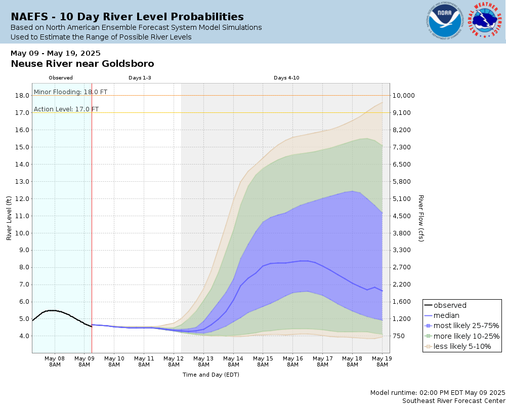
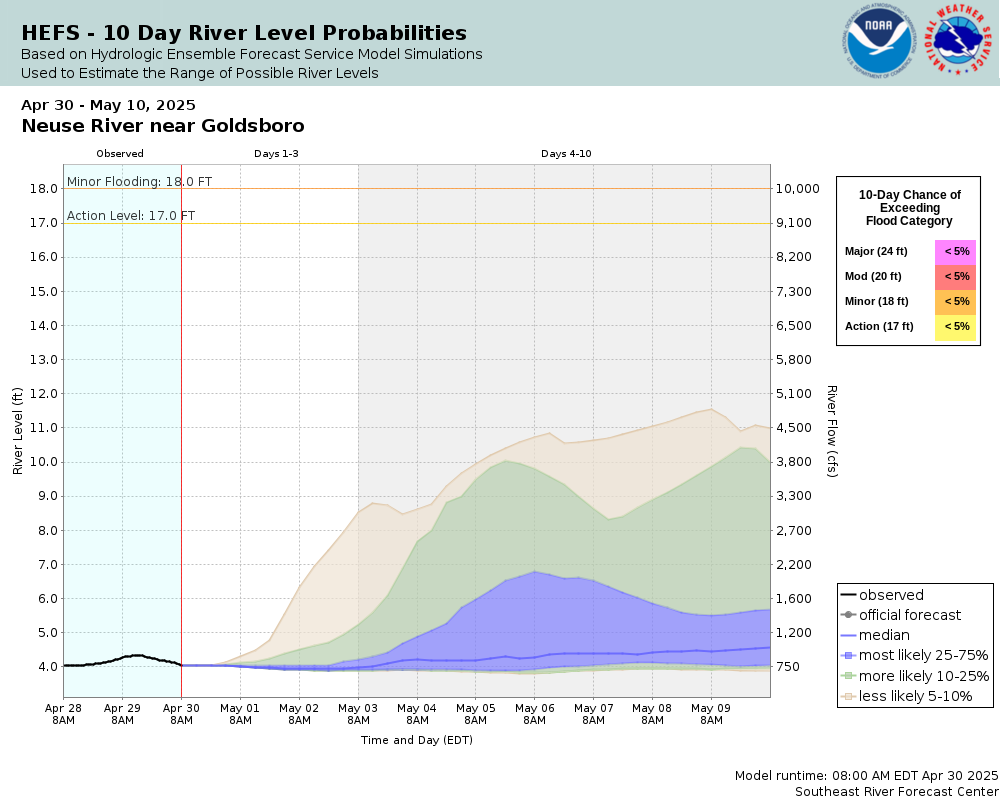
Potential River Levels
Used to Estimate the Chance of Flooding and the Range of Possible River Levels
10 day (HEFS) 7 Day (NAEFS) 7 Day (GEFS)
HEFS Ensemble NAEFS Ensemble GEFS Ensemble

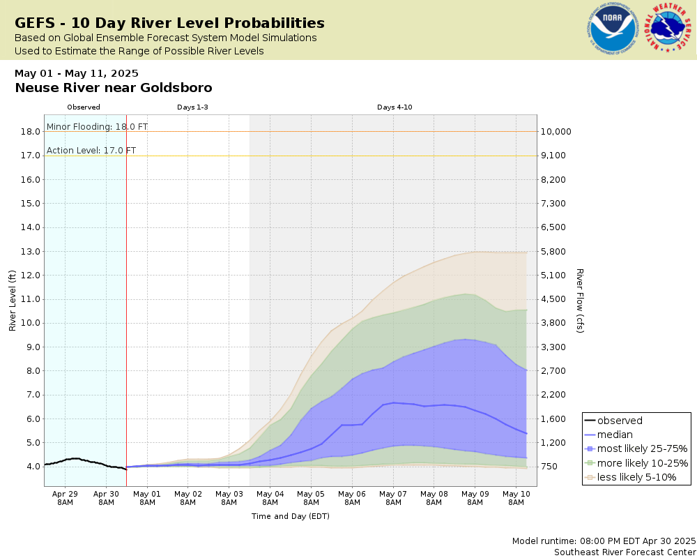
Note: Use the official hydrograph at the top of this web page for river levels within the next 72 Hours.


Gage Photos

Gage Photo

Resources Collapse
Hydrologic Resources Additional Resources
Collaborative Agencies Collapse
The National Weather Service prepares its forecasts and other services in collaboration with agencies like the US Geological Survey, US Bureau of Reclamation, US Army Corps of Engineers, Natural Resource Conservation Service, National Park Service, ALERT Users Group, Bureau of Indian Affairs, and many state and local emergency managers across the country. For details, please click here.
NWS Information
National Weather Service
Raleigh Weather Forecast Office
1005 Capability Drive, Suite 300
Raleigh, NC 27606
(919) 326-1042
Ask Questions/Webmaster
Page last modified: 2-Nov-2020 7:30 PM
Disclaimer
Credits
Glossary
Privacy Policy
About Us
Career Opportunities