Flint River (GA) at Bainbridge (US 27)
Future / Actual / Minor
OWP 2.0 WWA Modal Title
01/11/2021, 10:04 PM UTC through 01/11/2021, 10:04 PM UTC
Sender
Sent
- Warning: no valid ratings curve available. Transformations to and from FEET/CFS/KCFS will not happen.No secondary data available. Transformations for Flow data and a secondary Y axis cannot be made at this time.
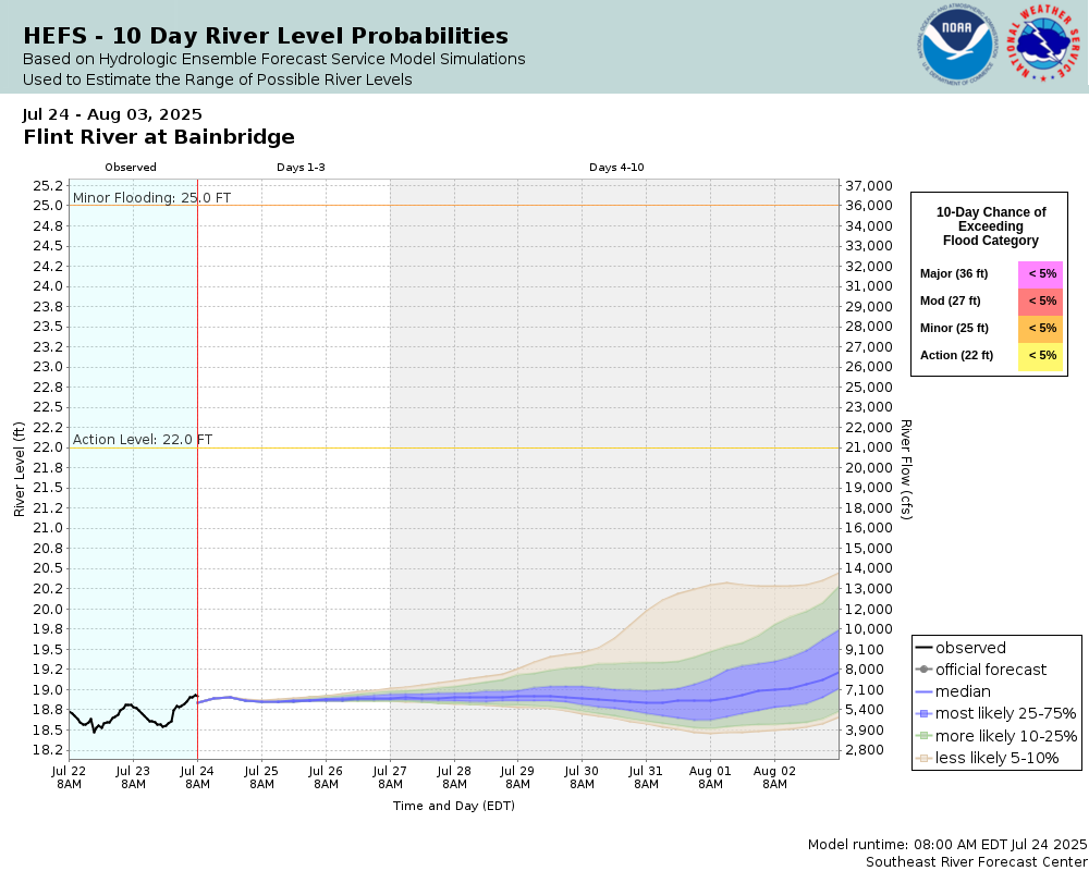
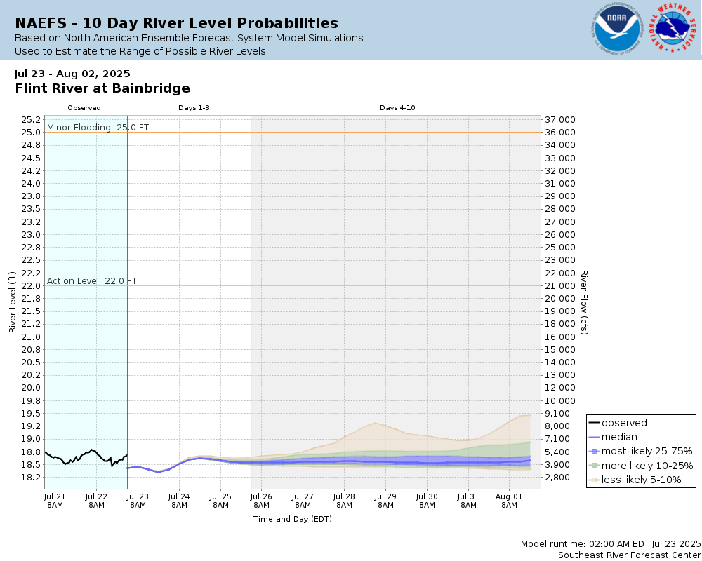
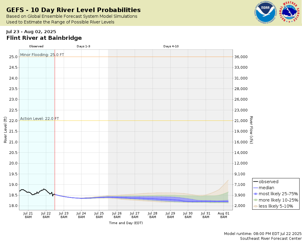
Traces and Thresholds Click to turn on/off display
CATEGORY STAGE Major Flooding 36 ft Moderate Flooding 27 ft Minor Flooding 25 ft Action 22 ft Reliability of the Forecast: Based on current and forecast river, weather and reservoir conditions
NOTE: Forecasts are issued as needed during times of high water, but are not routinely available.
River forecasts for this location take into account past precipitation and the precipitation amounts expected approximately 48 hours into the future from the forecast issuance time.
National Water Model Hydrograph
Official NWS streamflow forecasts are produced by NWS hydrologic forecasters for river gauge locations using hydrologic models which are calibrated to that location. This process considers additional guidance and information, including local expertise and experience, to produce the best forecast possible. The NWM output provides supplemental guidance to NWS forecasters and should not be considered an official NWS river forecast.
Flood Impacts
- 40 - Significant flooding occurs in West Bainbridge, especially in the vicinity of SR-253 (Newton Road). Residences west of Newton Road, north of Copeland Street and south of Bethel Road will be prone to flooding. There will be extensive damage to industrial locations along the river around the state docks. The state docks will be underwater. Further rises will increasely isolate low lying areas in West Bainbridge near the river.
- 38.01 - Widespread flooding with major damage to residents, roadways and on agricultural land along the river from the Mitchell County line to the City of Bainbridge. Major impact to homes in Flint River Heights, Aryola Drive, Meadow Ridge, River Road, Riverview subdivision, and Rivervale subdivision. These impacts can increase in severity based on the levels in Big Slough and Twin Lakes.
- 38 - Water will continue to expand into homes along Bethel Road. Water flooding Newton Road north of the Elberta Crate Company will make travel in the area impossible. Flooding will expand to include areas south of SR-253; Dickerson Street is impassible. In Bainbridge, water floods the interior of the Chamber of Commerce Building in the Boat Basin Area. These impacts can increase in severity based on the levels in Big Slough and Twin Lakes.
Gauge Info
| Coordinates | 30.9114, -84.5800 |
| RFC | SERFC |
| State | GA |
| WFO | TAE |
| County | Decatur |
| Data Provider(s) | |
| US Geological Survey | USGS--Water Resources of the United States |
| USGS | 02356000 |
Gauge Location
Recent Crests
| 1. | 27.23 ft | on 03-15-2024 |
| 2. | 25.58 ft | on 02-20-2024 |
| 3. | 23.26 ft | on 04-14-2022 |
| 4. | 30.49 ft | on 03-10-2020 |
| 5. | 27.16 ft | on 02-27-2020 |
Recent Crests
| 1. | 27.23 ft | on 03-15-2024 |
| 2. | 25.58 ft | on 02-20-2024 |
| 3. | 23.26 ft | on 04-14-2022 |
| 4. | 30.49 ft | on 03-10-2020 |
| 5. | 27.16 ft | on 02-27-2020 |
| 6. | 24.64 ft | on 02-10-2020 |
| 7. | 24.46 ft | on 12-06-2018 |
| 8. | 24.02 ft | on 01-26-2017 |
| 9. | 24.09 ft | on 04-08-2016 |
| 10. | 23.95 ft | on 02-07-2016 |
| 11. | 30.28 ft | on 01-04-2016 |
| 12. | 25.27 ft | on 04-23-2014 |
| 13. | 26.26 ft | on 03-01-2013 |
| 14. | 30.91 ft | on 04-07-2009 |
| 15. | 29.35 ft | on 04-01-2005 |
| 16. | 34.65 ft | on 03-13-1998 |
| 17. | 25.01 ft | on 02-15-1995 |
| 18. | 37.20 ft | on 07-14-1994 |
| 19. | 26.65 ft | on 03-08-1991 |
| 20. | 26.80 ft | on 03-25-1990 |
| 21. | 26.10 ft | on 03-01-1979 |
| 22. | 27.00 ft | on 01-31-1978 |
| 23. | 28.10 ft | on 03-24-1975 |
| 24. | 27.20 ft | on 03-12-1971 |
| 25. | 28.10 ft | on 04-04-1970 |
| 26. | 34.70 ft | on 04-16-1964 |
| 27. | 33.20 ft | on 04-05-1948 |
| 28. | 32.50 ft | on 03-29-1944 |
| 29. | 30.90 ft | on 04-17-1936 |
| 30. | 25.00 ft | on 10-09-1929 |
| 31. | 37.70 ft | on 03-31-1929 |
| 32. | 32.50 ft | on 04-27-1928 |
| 33. | 40.90 ft | on 01-24-1925 |
Historic Crests
| 1. | 40.90 ft | on 01-24-1925 |
| 2. | 37.70 ft | on 03-31-1929 |
| 3. | 37.20 ft | on 07-14-1994 |
| 4. | 34.70 ft | on 04-16-1964 |
| 5. | 34.65 ft | on 03-13-1998 |
Historic Crests
| 1. | 40.90 ft | on 01-24-1925 |
| 2. | 37.70 ft | on 03-31-1929 |
| 3. | 37.20 ft | on 07-14-1994 |
| 4. | 34.70 ft | on 04-16-1964 |
| 5. | 34.65 ft | on 03-13-1998 |
| 6. | 33.20 ft | on 04-05-1948 |
| 7. | 32.50 ft | on 03-29-1944 |
| 8. | 32.50 ft | on 04-27-1928 |
| 9. | 30.91 ft | on 04-07-2009 |
| 10. | 30.90 ft | on 04-17-1936 |
| 11. | 30.49 ft | on 03-10-2020 |
| 12. | 30.28 ft | on 01-04-2016 |
| 13. | 29.35 ft | on 04-01-2005 |
| 14. | 28.10 ft | on 04-04-1970 |
| 15. | 28.10 ft | on 03-24-1975 |
| 16. | 27.23 ft | on 03-15-2024 |
| 17. | 27.20 ft | on 03-12-1971 |
| 18. | 27.16 ft | on 02-27-2020 |
| 19. | 27.00 ft | on 01-31-1978 |
| 20. | 26.80 ft | on 03-25-1990 |
| 21. | 26.65 ft | on 03-08-1991 |
| 22. | 26.26 ft | on 03-01-2013 |
| 23. | 26.10 ft | on 03-01-1979 |
| 24. | 25.58 ft | on 02-20-2024 |
| 25. | 25.27 ft | on 04-23-2014 |
| 26. | 25.01 ft | on 02-15-1995 |
| 27. | 25.00 ft | on 10-09-1929 |
| 28. | 24.64 ft | on 02-10-2020 |
| 29. | 24.46 ft | on 12-06-2018 |
| 30. | 24.09 ft | on 04-08-2016 |
| 31. | 24.02 ft | on 01-26-2017 |
| 32. | 23.95 ft | on 02-07-2016 |
| 33. | 23.26 ft | on 04-14-2022 |
Vertical Datum Table
| type | NGVD29 |
|---|---|
| major Flooding | 93.70 ft |
| moderate Flooding | 84.70 ft |
| minor Flooding | 82.70 ft |
| action | 79.70 ft |
| Latest Value | 76.34 ft |
| Gauge Zero | 57.70 ft |


Unique Local Info
Collaborative Agencies
The National Weather Service prepares its forecasts and other services in collaboration with agencies like the US Geological Survey, US Bureau of Reclamation, US Army Corps of Engineers, Natural Resource Conservation Service, National Park Service, ALERT Users Group, Bureau of Indian Affairs, and many state and local emergency managers across the country. For details, please click here.