Skip Navigation Link weather.gov  
NOAA logo - Click to go to the NOAA homepage National Weather Service NWS logo - Click to go to the NWS homepage
Advanced Hydrologic Prediction Service
Image background of Navigation bar Left
Navigation Bar End Cap


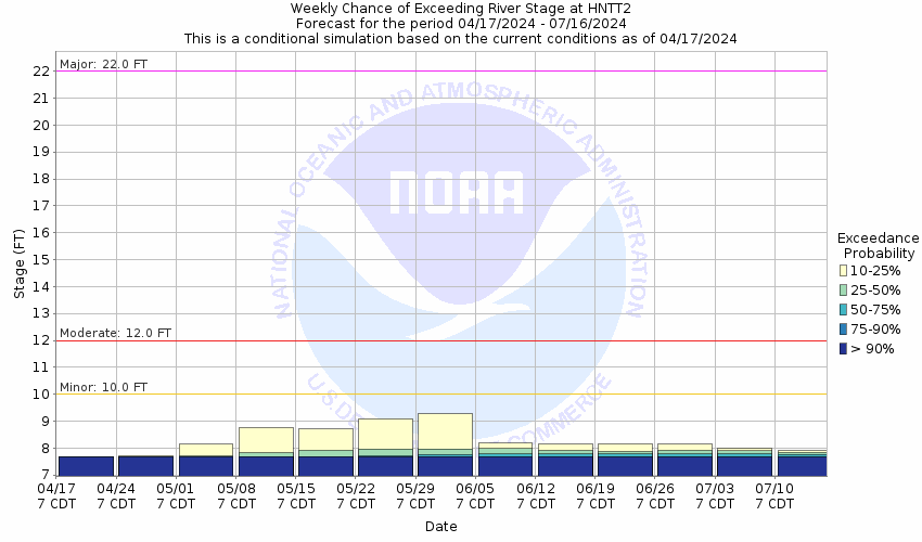
This probabilistic forecast is issued by the West Gulf River Forecast Center.
tab left off Hydrograph tab right off tab left off River at a Glance tab right off tab left off Download tab right off tab left on tab right on
About this graph
Forecasts for the Guadalupe River at Hunt are issued routinely year-round.
Return to Area Map

Zoom Level:16
Flood Categories (in feet)
Major Flood Stage: 22
Moderate Flood Stage: 12
Flood Stage: 10
Action Stage: 10
Low Stage (in feet): -9999

Historic Crests
(1) 36.60 ft on 07/02/1932
(2) 28.40 ft on 07/17/1987
(3) 23.50 ft on 08/02/1978
(4) 22.80 ft on 10/19/1985
(5) 21.40 ft on 08/13/1981
Show More Historic Crests

(P): Preliminary values subject to further review.

Recent Crests
(1) 18.96 ft on 10/16/2018
(2) 14.89 ft on 10/09/2018
(3) 10.58 ft on 05/24/2015
(4) 15.00 ft on 05/25/2007
(5) 16.70 ft on 07/05/2002
Show More Recent Crests

(P): Preliminary values subject to further review.

Low Water Records
Currently none available.
KML Image
Gauge LocationGauge Map Marker
Disclaimer
Latitude/Longitude Disclaimer: The gauge location shown in the above map is the approximate location based on the latitude/longitude coordinates provided to the NWS by the gauge owner.
Flood Impacts & Photos Collapse
If you notice any errors in the below information, please contact our Webmaster
32 Disastrous life threatening flooding puts water over the roads of lowest camps and resorts from the headwaters of the North and South Forks to below Comfort. Much of Highways 27 and 39 will flood as the disastrous flood wave moves downstream over the next several hours. Motorists should avoid any travel in the flood plain. Low residences above Center Point to below Comfort will flood. Many homes and businesses in Kerrville will flood.
28 Life threatening flooding puts water to the roofs of lowest facilities and dwellings of resort camps along the South Fork above River Inn to Hunt. Roads near the river are deadly to auto travel. Lowest homes will flood in the North Fork as well as outbuildings, tennis courts and swimming pools. Lowest homes near Center Point and below to Comfort flood. Flow exceeds the USGS 1:25 year flood.
25 Major flooding severely floods resort camps along the South Fork below the River Inn resort to Hunt. Parts of Highway 39 are flooded and very dangerous as well as numerous secondary roads and bridges. Areas in the flood plain are cut off. Residents cut off by Highay 39 flooding should stay put rather than drive on extremely dangerous roads escaping. Lowest homes downstream near Center Point will flood.
22 Major flooding of low areas of recreation camps along the North and South Forks washes canoes and gear downstream from docks and low areas. Roads near the river, including along Highway 39, are extremely dangerous for auto traffic and travel is highly discouraged. Autos in low areas of Camp Waldemar are swept downstream. Flow is near the USGS 1:10 year flood level.
18 Automobiles parked near the North Fork of the Guadalupe River at Camp Waldemar wash downstream. Roads and low bridges near the North and South Forks flood badly and are dangerous to motorists. The Highway 39 bridge floor near Hunt is under six feet of water. Some residents are cut off and should stay put. Secondary roads and bridges near the river are extremely dangerous to motorists. Near the USGS 1:5 year flood level.
15 Moderate lowland flooding puts a few feet of water over the Highway 39 bridge near Hunt. Numerous secondary roads and bridges are flooded and very dangerous.
12 Moderate lowland flooding reaches the Highway 39 bridge floor two miles east of Hunt preventing easy travel to western parts of the county. Areas of the headwaters are isolated temporarily as low water crossings flood.
10 Water extends into low areas of the flood plain.
7 Flow extends over low sections of the banks.

Other Real-time and/or Archive Data Sources:

Collaborative Agencies Collapse
The National Weather Service prepares its forecasts and other services in collaboration with agencies like the US Geological Survey, US Bureau of Reclamation, US Army Corps of Engineers, Natural Resource Conservation Service, National Park Service, ALERT Users Group, Bureau of Indian Affairs, and many state and local emergency managers across the country. For details, please click here.
NWS Information
National Weather Service
Austin/San Antonio Weather Forecast Office
2090 Airport Road
New Braunfels, TX 78130
(830) 629-0130
Ask Questions/Webmaster
Page last modified: 2-Nov-2020 7:29 PM
Disclaimer
Credits
Glossary
Privacy Policy
About Us
Career Opportunities