Skip Navigation Link weather.gov  
NOAA logo - Click to go to the NOAA homepage National Weather Service NWS logo - Click to go to the NWS homepage
Advanced Hydrologic Prediction Service
Image background of Navigation bar Left
Navigation Bar End Cap


This probabilistic forecast is issued by the West Gulf River Forecast Center.
tab left off Hydrograph tab right off tab left off River at a Glance tab right off tab left off Download tab right off tab left on tab right on
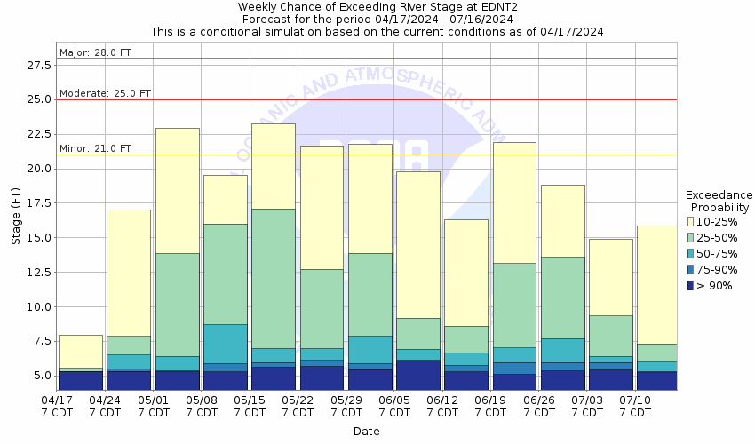
About this graph
Forecasts for the Lavaca River near Edna are issued as needed during times of high water, but are not routinely available.
Return to Area Map

Upstream Gauge - at Hallettsville Upstream Gauge
Zoom Level:16
Flood Categories (in feet)
Major Flood Stage: 28
Moderate Flood Stage: 25
Flood Stage: 21
Action Stage: 20
Low Stage (in feet): -9999

Historic Crests
(1) 35.49 ft on 10/19/1994
(2) 33.80 ft on 05/25/1936
(3) 32.53 ft on 08/29/2017
(4) 32.51 ft on 07/01/1940
(5) 32.38 ft on 10/19/1998
Show More Historic Crests

(P): Preliminary values subject to further review.

Recent Crests
(1) 21.40 ft on 02/02/2022 (P)
(2) 23.55 ft on 07/10/2021 (P)
(3) 26.14 ft on 06/05/2021 (P)
(4) 24.11 ft on 12/10/2018 (P)
(5) 22.55 ft on 10/25/2018 (P)
Show More Recent Crests

(P): Preliminary values subject to further review.

Low Water Records
Currently none available.
KML Image
Gauge LocationGauge Map Marker
Disclaimer
Latitude/Longitude Disclaimer: The gauge location shown in the above map is the approximate location based on the latitude/longitude coordinates provided to the NWS by the gauge owner.
Flood Impacts & Photos Collapse
If you notice any errors in the below information, please contact our Webmaster
35 Disastrous flooding continues with the west approach to the Highway 59 bridge inundated and closed. Several homes in the Lavaca River floodplain above Highway 59 into northern Jackson County are flooded. Hundreds of head of livestock may be cut off and drown in low areas.
34 Disastrous flooding continues with water is to the low steel of the Highway 59 bridge. Several homes in the floodplain above highway 59 are flooded with widespread inundation of primary and secondary roads. Hundreds of head of livestock may be cut off and drown in low pasture areas.
33 Disasterous flooding occurs with the lowest homes above highway 59 flooded and there is several feet of water over secondary roads and low bridges. Flow is within inches of spilling over the approaches to the Highway 59 bridge. Hundreds of head of livestock above Highway 59 to below Hallettesville may be isolated and drown.
30 Major lowland flooding continues with the river over one half mile side near the Highway 59 bridge. Numerous roads and bridges in the floodplain are inundated and closed. Livestock are isolated well into the floodplain.
28 Major lowland flooding begins with the river one half mile wide near the Highway 59 bridge. Primary roads and low bridges are flooded and secondary roads are closed. Livestock are isolated with widespread inundation of crop and pasture land.
25 Moderate lowland flooding begins with the river one third of a mile wide near the Highway 59 bridge flooding secondary roads and bridges along the river. Livestock are isolated and potentially drown.
23 Flooding along the Lavaca River reaches hundreds of yards into the lower floodplain backing up sloughs and low areas. Minor roads and near the river flood and livestock are isolated.
22 Flooding along the Lavaca River reaches well into the lower floodplain backing up sloughs and low areas.
21 Minor lowland flooding begins with flow backing through preipheral channels adjacent to the river and reaches into sloughs and low areas.
20 At levels above 20 feet flow exceeds the lowest sections of both banks.

Other Real-time and/or Archive Data Sources:

Collaborative Agencies Collapse
The National Weather Service prepares its forecasts and other services in collaboration with agencies like the US Geological Survey, US Bureau of Reclamation, US Army Corps of Engineers, Natural Resource Conservation Service, National Park Service, ALERT Users Group, Bureau of Indian Affairs, and many state and local emergency managers across the country. For details, please click here.
NWS Information
National Weather Service
Houston/Galveston Weather Forecast Office
1353 FM 646, Suite 202
Dickinson, TX 77539
(281) 337-5074
Ask Questions/Webmaster
Page last modified: 2-Nov-2020 7:29 PM
Disclaimer
Credits
Glossary
Privacy Policy
About Us
Career Opportunities