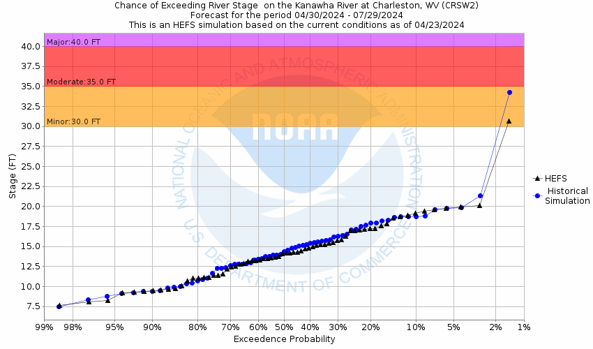
| If you notice any errors in the below information, please contact our Webmaster |
| 48 |
Major flooding of the City of Charleston and surrounding areas. |
| 47 |
Kanawha Boulevard near the South Side Bridge is flooded. |
| 44 |
Water reaches the base of homes along Kanawha Boulevard, west of the interstate bridge, near Magic Island. Kanawha Boulevard is also flooded in this area. Sections of MacCorkle Avenue (Route 61) near the interstate bridge are flooded. |
| 43 |
Water is at the base of Union building on Kanawha Boulevard. |
| 40 |
The South Side Bridge parking lot along Kanawha Boulevard is flooded. |
| 38.7 |
Water is to bottom of Haddad Riverfront Park bathrooms and most of park is flooded. |
| 38 |
The CSX Railroad tracks, Kanawha Boulevard, and Park Avenue on the west side of Charleston begins to flood. |
| 35 |
Low sections of MacCorkle Avenue between the South Side Bridge, the Thirty Fifth Street bridge, Thirty Fifth, and Thirty Third Streets in Kanawha City begin to flood. |
| 32 |
U.S. Route 60, Patrick Street and U.S. Route 119 in the City of Charleston begin to flood. |
| 31.6 |
Patrick Street at 6th Avenue begins to flood. |
| 30 |
Bigley Avenue at Magazine Branch begins to flood. |
| 29.5 |
Crescent Road at Magazine Branch begins to flood. |
| 29.3 |
Grant Street at Elm Street begins to flood. |
| 29 |
The railroad underpass on US Route 119 (Corridor G), near its intersection with MacCorkle Ave, begins to flood from backwater up Ferry Branch. Water also backs up Lower Donnally Branch and begins to flood the 4400 block dip in Kanawha Ave in Kanawha City. |
| 28 |
The protective earth dike/levee, around the South Charleston Community Center, has accumulating backwater near its top. Also, the lower west end of Spring Hill in South Charleston has backwater pool in the vicinity of Roxbury, Kentucky, and Ohio Streets. |
| 27 |
Iowa Street at 5th Avenue begins to flood due to backwater up Kanawha Two Mile. Also, Gap View Drive begins to flood near the WV DOH Materials Building from backwater up Campbells Creek and Dry Branch. |
| 25.5 |
The lower riverbank sidewalk, along Kanawha Blvd, begins to flood. |
| 25 |
Oregon Street, 6th Avenue, and Kemp Avenue have water backing up from Kanawha Two Mile - and pools near homes. Also, the lower parking lot #2 of the Kenna Homes off Kenna Drive in South Charleston begins to flood. |
| 24.5 |
Concrete splash pads on Magic Island begin to flood. |
| 24 |
Pooling backwater reaches around the base of the South Charleston Community Center protective earth dike/levee. (also the elevation of their gym floor) |
| 23.6 |
The North Charleston Fire Department basement begins to flood. |
| 23.5 |
Piedmont Road and Dry Branch Drive flood from backwater up Campbells Creek. |
| 22 |
Portions of Magic Island are under water. Backwater flooding starts along the Elk River portion of the city. Additionally, a catch basin field between the South Charleston Community Center and Kenna Homes begins to accumulate backwater. This water comes up through the drains that feed into Davis Creek. |
| 20 |
The concrete floor of the elevated stage at Haddad Riverfront Park is flooded. |
| 17.5 |
Water is up to the bottom steps of the seating area in Haddad Riverfront Park. Also, the lower loop road to the boat ramp at Daniel Boone Park floods. |
| 17.2 |
Upper pier of Haddad Riverfront Park is flooded. |
| 12 |
Bottom pier of Haddad Riverfront Park is flooded. |
Photos
(1) View from above
(2) South Side Bridge gage
(3) South Side Bridge Staff gage
(4) Upstream View
(5) Downstream View
|


