Skip Navigation Link weather.gov  
NOAA logo - Click to go to the NOAA homepage National Weather Service NWS logo - Click to go to the NWS homepage
Advanced Hydrologic Prediction Service
Image background of Navigation bar Left
Navigation Bar End Cap


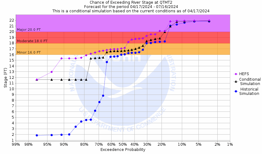
This probabilistic forecast is issued by the West Gulf River Forecast Center.
tab left off Hydrograph tab right off tab left off River at a Glance tab right off tab left off Download tab right off tab left on tab right on
About this graph
Forecasts for the Lake Fork Creek near Quitman are issued as needed during times of high water, but are not routinely available.
Return to Area Map

Upstream Gauge - at Lake Fork Upstream Gauge Downstream Gauge Downstream Locations
Zoom Level:16
Flood Categories (in feet)
Major Flood Stage: 20
Moderate Flood Stage: 18
Flood Stage: 16
Action Stage: 15.5
Low Stage (in feet): 0

Historic Crests
(1) 29.85 ft on 03/30/1945
(2) 25.90 ft on 06/07/1943
(3) 25.90 ft on 07/01/1895
(4) 25.10 ft on 12/10/1971
(5) 24.38 ft on 04/28/1958
Show More Historic Crests

(P): Preliminary values subject to further review.

Recent Crests
(1) 19.02 ft on 05/09/2019
(2) 18.92 ft on 02/23/2018
(3) 16.84 ft on 08/15/2017
(4) 17.12 ft on 06/03/2016
(5) 20.17 ft on 04/30/2016
Show More Recent Crests

(P): Preliminary values subject to further review.

Low Water Records
(1) 1.86 ft on 09/01/1956
KML Image
Gauge LocationGauge Map Marker
Disclaimer
Latitude/Longitude Disclaimer: The gauge location shown in the above map is the approximate location based on the latitude/longitude coordinates provided to the NWS by the gauge owner.
Flood Impacts & Photos Collapse
If you notice any errors in the below information, please contact our Webmaster
22 Numerous barns as well as farm buildings will be threatened with serious flooding. All cattle and equipment should be evacuated well away from the creek. Preparations should be rushed to completion for severe flooding. The creek will remain above flood stage for several days as necessary releases to lower high water levels at lake fork continue.
20 Lowland flooding will continue to slowly decrease as reservoir releases from lake fork dam will continue to slowly decrease.
19 Preparations should be rushed to completion for major flooding problems. Some barns in the floodplain will be facing flooding.
16 Expect minor lowland flooding problems. Ranchers that may have cattle and equipment in the creek bottoms should move them to higher ground.

Other Real-time and/or Archive Data Sources:

Additional Information Collapse
During periods of possible very heavy rainfall, river forecasts may take into account precipitation amounts expected 30, 36, or even 48 hours into the future from the forecast issuance time.
Collaborative Agencies Collapse
The National Weather Service prepares its forecasts and other services in collaboration with agencies like the US Geological Survey, US Bureau of Reclamation, US Army Corps of Engineers, Natural Resource Conservation Service, National Park Service, ALERT Users Group, Bureau of Indian Affairs, and many state and local emergency managers across the country. For details, please click here.
NWS Information
National Weather Service
Shreveport Weather Forecast Office
5655 Hollywood Avenue
Shreveport, LA 71109
(318) 631-3669
Ask Questions/Webmaster
Page last modified: 2-Nov-2020 7:29 PM
Disclaimer
Credits
Glossary
Privacy Policy
About Us
Career Opportunities