Latitude/Longitude Disclaimer: The gauge location shown in the above map
is the approximate location based on the latitude/longitude coordinates
provided to the NWS by the gauge owner.
Flood Impacts & Photos
If you notice any errors in the below information, please contact our Webmaster
18
479th Avenue begins to flood south of Castlewood.
17
Highway 22 begins to flood, as does 181st Street, and water reaches the bottom of the bridge on 459th Avenue south of Castlewood.
16
The river will be about 1 mile wide and many farm buildings around Castlewood will be flooded.
15
The water reaches the bottom of the bridges on Highway 22 and 181st Street.
13
Major agricultural flooding begins south of Castlewood.
11
Significant amounts of pasture and other agricultural lands will be flooded.
10
184th Street begins to flood.
9
Water overtops the culvert on 184th Street and significant agricultural flooding begins north of Castlewood.
8
Minor flooding of low-lying agricultural lands along the river will begin.
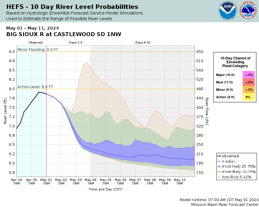
Effective on Friday, June 1 2012, the Minor Flood Stage has been changed to 9.0 feet, and the Moderate Flood Stage changed to 11.0 feet.
How low could the river
get?
Collaborative Agencies
The National Weather Service prepares its forecasts and other services in collaboration with agencies like the US Geological Survey, US Bureau of Reclamation, US Army Corps of Engineers, Natural Resource Conservation Service, National Park Service, ALERT Users Group, Bureau of Indian Affairs, and many state and local emergency managers across the country. For details, please click here.
NWS Information
National Weather Service
Aberdeen Weather Forecast Office
824 Brown County 14 South
Aberdeen, SD 57401 Ask Questions/Webmaster
Page last modified: 2-Nov-2020 7:29 PM


