Skip Navigation Link weather.gov  
NOAA logo - Click to go to the NOAA homepage National Weather Service NWS logo - Click to go to the NWS homepage
Advanced Hydrologic Prediction Service
Image background of Navigation bar Left
Navigation Bar End Cap


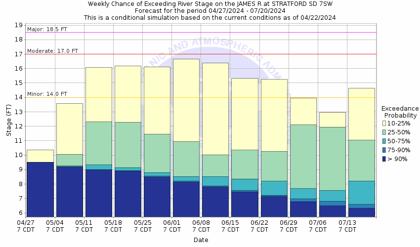
This probabilistic forecast is issued by the Missouri Basin River Forecast Center.
tab left off Hydrograph tab right off tab left off River at a Glance tab right off tab left off Download tab right off tab left on tab right on
About this graph
Forecasts for the James River near Stratford are issued as needed during times of high water, but are not routinely available.
Return to Area Map

Upstream Gauge - near Columbia Upstream Gauge Downstream Gauge Downstream Gauge - near Ashton
Zoom Level:14
Flood Categories (in feet)
Major Flood Stage: 18.5
Moderate Flood Stage: 17
Flood Stage: 14
Action Stage: 13
Low Stage (in feet): -9999

Historic Crests
(1) 21.57 ft on 07/19/2011
(2) 20.08 ft on 03/29/2010
(3) 19.98 ft on 04/26/2009
Show More Historic Crests

(P): Preliminary values subject to further review.

Recent Crests
(1) 18.43 ft on 04/18/2020
(2) 18.68 ft on 04/19/2019
(3) 14.08 ft on 03/29/2017
Show More Recent Crests

(P): Preliminary values subject to further review.

Low Water Records
Currently none available.
KML Image
Gauge LocationGauge Map Marker
Disclaimer
Latitude/Longitude Disclaimer: The gauge location shown in the above map is the approximate location based on the latitude/longitude coordinates provided to the NWS by the gauge owner.
Flood Impacts & Photos Collapse
If you notice any errors in the below information, please contact our Webmaster
27 The bridge at the gauging location is overtopped.
25 The water reaches the bottom of the bridge at the gauging location.
22 The bridge 3 miles south of the gauge is overtopped.
20 142nd Street is flooded.
19.5 The bridge on 148th Street is under water.
19 The water reaches the bottom of the bridge 3 miles south of the gauge.
18.5 395th Avenue is flooded and the road and bridge on 146th Street is under water.
17.5 The water reaches the bottom of the bridge 2 miles north of the gauge.
17 County roads begin flooding and the road 2 miles north of the gauging location is one of the first to flood.
16 137th Street and 140th Street are flooded.
14 Significant amounts of agricultural lands begin flooding.

Other Real-time and/or Archive Data Sources:

Additional Information Collapse
11/30/2009. MODERATE FLOOD STAGE CHANGED TO 17.0 FEET. MAJOR FLOOD STAGE CHANGED TO 18.5 FEET.
How low could the river get?
Collaborative Agencies Collapse
The National Weather Service prepares its forecasts and other services in collaboration with agencies like the US Geological Survey, US Bureau of Reclamation, US Army Corps of Engineers, Natural Resource Conservation Service, National Park Service, ALERT Users Group, Bureau of Indian Affairs, and many state and local emergency managers across the country. For details, please click here.
NWS Information
National Weather Service
Aberdeen Weather Forecast Office
824 Brown County 14 South
Aberdeen, SD 57401
Ask Questions/Webmaster
Page last modified: 2-Nov-2020 7:29 PM
Disclaimer
Credits
Glossary
Privacy Policy
About Us
Career Opportunities